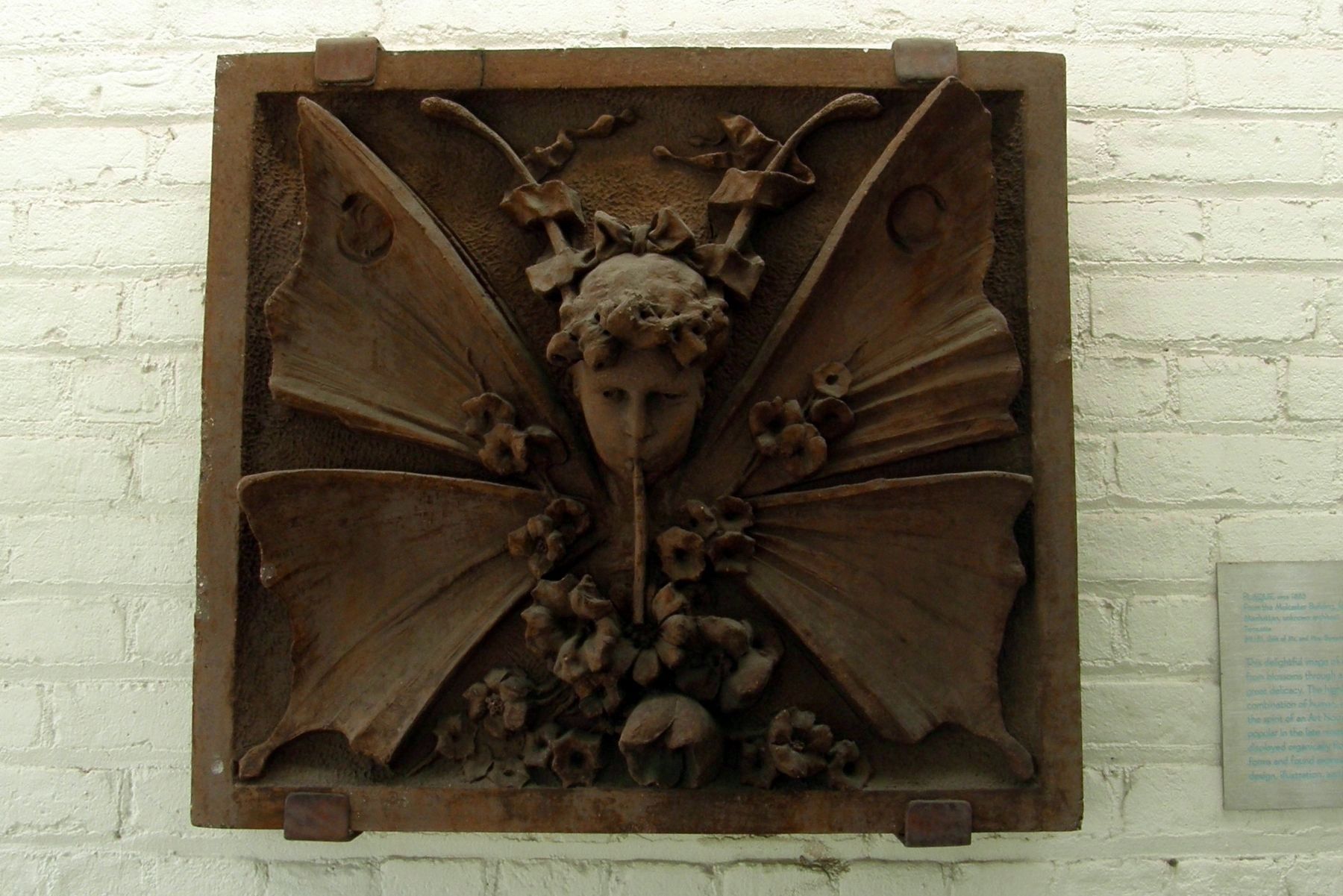
Plaque, circa 1885
From the Mulcaster Building, formerly at 1297 3rd Avenue at 68th Street, Manhattan, unknown architect
Terracotta
69.181, Gift of Mr. and Mrs. Benjamin Frost
This delightful image of a butterfly-child sipping nectar from . . . — — Map (db m109513) HM
Near Flatbush Avenue 0.1 miles north of Empire Boulevard, on the right when traveling north.
More than 7,000 years ago, people living in the Andes Mountains began cultivating the potato, eventually growing thousands of different kinds. Along the way they also developed chuño, potatoes preserved by freeze-drying, for use during food . . . — — Map (db m204038) HM
Unknown Artist and Maker
(American, Akron, Ohio)
Replica of the Statue of Liberty, circa 1900
Galvanized sheet steel and zinc over iron frame
Gift of the Athena-Liberty Lofts, L.P., The Athena group, and Brickman Associates, in honor of the . . . — — Map (db m109515) HM
Created in 1917 and expanded in 1992, this boulder-strewn slope showcases compact plants suited for growing in shallow, arid soils.
Most of the plants here need good drainage and little water. The microclimates created by the . . . — — Map (db m204047) HM
Near Flatbush Avenue north of Empire Boulevard, on the right when traveling north.
One of two species of Douglas fir, an important North American timber tree. The Okanagan Colville tribe in the Pacific Northwest used this tree for tent poles and spear shafts. Look for the cones easily identified by "rabbit ear" scales. — — Map (db m204055) HM
Near Flatbush Avenue 0.1 miles north of Empire Boulevard, on the right when traveling north.
Sub-Saharan Africa
Crops like pearl millet and sorghum were first cultivated at least 5,000 years ago in savannas south of the Sahara Desert. These plants have extensive root systems well suited to the long dry season of this region. . . . — — Map (db m204029) HM
Near Flatbush Avenue 0.1 miles north of Empire Boulevard, on the right when traveling north.
Did you know grass can taste sweet too? Sugarcane is a tall, tropical grass that is used to make about 70% of sugar in the world. For over 100 years, enslaved Africans were forced to work on sugarcane plantations in the Caribbean to produce millions . . . — — Map (db m204010) HM
Near Flatbush Avenue north of Empire Boulevard, on the right when traveling north.
The poppy-seed-size grain is mostly grown in its native Ethiopia, where it is adapted to extreme heat and drought. Injera, a spongy flat bread made of fermented teff flour, has been a staple food in the region for centuries. — — Map (db m204034) HM
In the gardens of Japan, nature is rarefied, abstracted, and interpreted to reveal lessons about life and our own place in the larger scheme of things. Symbolic elements imbue the landscape with deeper meaning. Among the major features of the . . . — — Map (db m106162) HM
Near Flatbush Avenue 0.1 miles north of Empire Boulevard, on the right when traveling north.
Espalier (es-PAL-yay) is the art of training woody trees and shrubs, usually on a wall or fence. A painting of an espaliered fig tree in an ancient Egyptian tomb shows this pruning method to be thousands of years old. . . . — — Map (db m204035) HM
Near Flatbush Avenue 0.1 miles north of Empire Boulevard, on the right when traveling north.
Turmeric plants are harvested for their brightly colored underground stems, called rhizomes. Turmeric rhizomes have been used for over a century for medicine, food, and in spiritual practices in the Caribbean. A key ingredient in curry, turmeric is . . . — — Map (db m204003) HM
Near Flatbush Avenue north of Empire Boulevard, on the right when traveling north.
This impressive tree is planted in large gardens and old estates for its large, unusual form. Native to European woods, this cultivar was first planted in NYC in 1847. View the larger native American beech in Bluebell Wood—both have coppery fall . . . — — Map (db m204048) HM
Near Flatbush Avenue just north of Empire Boulevard, on the right when traveling north.
Enjoy your visit to Brooklyn Botanic Garden, 52 acres of specialty gardens featuring more than 12,000 species and cultivars of plants from around the world.
Be sure to stop by the Steinberg Visitor Center to learn about membership, programs, . . . — — Map (db m203989) HM
Near Flatbush Avenue north of Empire Boulevard, on the right when traveling north.
"Adapting to new spaces isn't always easy for me. When I read about birds who adapt objects into nests, I wanted to learn more about them. Wenenoke is for birds that adapt found objects into nests. Bird bottles, or 'martin pots,' were used in . . . — — Map (db m204075) HM
Near Flatbush Avenue 0.1 miles north of Empire Boulevard, on the right when traveling north.
Among the oldest plant dyes, woad was one of the holy trinity of medieval dye plants, along with weld (Reseda luteola) and madder (Rubia tinctorum). These swatches were dyed using a homemade vat method. — — Map (db m204015) HM
Near Flatbush Avenue 0.1 miles north of Empire Boulevard, on the right when traveling north.
Plants are the primary producers of the oxygen and food that we need to survive—and they also play important roles in almost every aspect of our daily lives.
Untapped Possibility
People have used plants medicinally since prehistoric . . . — — Map (db m204019) HM
On Clinton Street at Livingston Street, on the right when traveling north on Clinton Street.
This house was the former home of the Brooklyn Excelsiors, baseball champions of the United States in 1860. Constructed in 1851, the building was once the Jolly Young Bachelors clubhouse. The Bachelors evolved into the Excelsiors baseball team. One . . . — — Map (db m181657) HM
On Willow Street 0.1 miles south of Clark Street, on the left when traveling south.
Built of brick laid in Flemish Bond, these three buildings, all listed in city directories prior to 1830, are among the best surviving examples of Federal Style row houses of the early nineteenth century. An underground tunnel, lighted by a skylight . . . — — Map (db m33730) HM
On State Street just east of Columbia Place, on the right when traveling east.
Located in the southernmost portion of Brooklyn Heights, this playground is named after Adam "MCA" Yauch (1964-2012), a founding member of the 1980's punk/hip hop band The Beastie Boys.
This property was acquired by the City in 1944 as part . . . — — Map (db m241427) HM
On Montague Street just east of Montague Terrace, on the left when traveling west.
Pulitzer Prize-winning playwright Arthur Miller transformed post-World War II theater with explorations of social injustice, individual responsibility, and the American dream. For more than 70 years he created screenplays, fiction, essays, an . . . — — Map (db m181623) HM
On Old Fulton Street at Furman Street, on the right when traveling west on Old Fulton Street.
This tablet marks the Brookland Ferry Landing from which point the American Army embarked during the night of August 29th, 1776 under the direction of General George Washington ably assisted by Colonel John Glover of Marblehead, Massachusetts . . . — — Map (db m258800) HM
Brooklyn's oldest building, this porticoed Greek Revival structure, designed by Gamaliel King, was built in 1846-51 as Brooklyn's City Hall. The cupola was added in 1898 when Brooklyn was consolidated into Greater New York City, and the building . . . — — Map (db m146163) HM
The various shoreline conditions found in the park increase ecological diversity and act as a protective buffer during storms and major floods. A constructed version of a natural costal environment, THE SALT MARSH creates a dynamic tidal . . . — — Map (db m263983) HM
On Furman Street south of Old Fulton Street, on the right when traveling north.
This handsome red brick building was built in 1860-61 as offices for the city of Brooklyn Railroad Company, one of New York City's first large-scale transit operators. By 1867, the company served 22 million passengers annually, operating twelve . . . — — Map (db m307661) HM
On Court Street at Remsen Street, on the right when traveling north on Court Street.
Notables from George Washington to writers and artists, gravitate to Brooklyn Heights.
Encouraged by Robert Fulton’s ferry from Manhattan in 1814, residents built handsome houses of wood, brick and brownstone in all the principal styles of the . . . — — Map (db m134834) HM
On Montague Street at Pierrepont Place, on the right when traveling west on Montague Street.
Brooklyn Heights
Notables, from George Washington to writers and artists, gravitate to Brooklyn Heights.
Encouraged by Robert Fulton's ferry from Manhattan in 1814, residents built handsome houses of wood, brick and brownstone in all . . . — — Map (db m181616) HM
On Court Street at Joralemon Street, on the right when traveling south on Court Street.
Brooklyn Heights
Notables, from George Washington to writers and artists, gravitate to Brooklyn Heights.
Encouraged by Robert Fulton's ferry from Manhattan in 1814, residents built handsome houses of wood, brick and brownstone in all . . . — — Map (db m241423) HM
On Henry Street at Clark Street, on the right when traveling south on Henry Street.
Brooklyn Heights
Notables, from George Washington to writers and artists, gravitate to Brooklyn Heights.
Encouraged by Robert Fulton's ferry from Manhattan in 1814, residents built handsome houses of wood, brick and brownstone in all . . . — — Map (db m253845) HM
On Pierrepont Street west of Clinton Street, on the right when traveling east.
Brooklyn Heights, with its elegant promenade and dramatic view of Manhattan, is one of the most uniformly preserved 19th century residential districts in New York City. It was developed soon after 1814, when Robert Fulton's first steam-powered . . . — — Map (db m33085) HM
On Clark Street at Henry Street, on the right when traveling east on Clark Street.
Brooklyn Heights, with its elegant promenade and dramatic view of Manhattan, is one of the most uniformly preserved 19th century residential districts in New York City. It was developed soon after 1814 when Robert Fulton's first steam powered ferry, . . . — — Map (db m209655) HM
On Columbia Heights at Orange Street, on the left when traveling north on Columbia Heights.
Brooklyn Heights, with its elegant promenade and dramatic view of Manhattan, is one of the most uniformly preserved 19th century residential districts in New York City. It was developed soon after 1814, when Robert Fulton's first steam-powered . . . — — Map (db m253847) HM
On Willow Street west of Poplar Street, on the right when traveling east.
Brooklyn Heights, with its elegant promenade and dramatic view of Manhattan, is one of the most uniformly preserved 19th century residential districts in New York City. It was developed soon after 1814, when Robert Fulton's first steam-powered . . . — — Map (db m253868) HM
On Pierrepont Street at Columbia Heights, on the right when traveling west on Pierrepont Street.
Brooklyn Heights, with its elegant promenade and dramatic view of Manhattan, is one of the most uniformly preserved 19th century residential districts in New York City. It was developed soon after 1814, when Robert Fulton's first steam-powered . . . — — Map (db m253874) HM
On Joralemon Street near Court Street, on the left when traveling west.
McKenzie, Voorhees and Gmelin designed this structure in a modified Roman Eclectic style. The interior marble was quarried in Tennessee and Vermont, the granite for its base in Deer Island, Maine, and most of its limestone façade in Indiana. This . . . — — Map (db m284348) HM
On Cadman Plaza West 0.1 miles north of Pineapple Walk, on the right when traveling north.
This memorial is dedicated to the heroic men and women of the Borough of Brooklyn who fought for liberty in the Second World War 1941-1945 and especially to those who suffered and died. May their sacrifice inspire future generations and lead to . . . — — Map (db m183092) WM
On Cadman Plaza East south of Red Cross Place, on the right when traveling south.
This granite and limestone memorial in Brooklyn's Cadman Plaza is dedicated to the more than 300,000 "heroic men and women of the borough of Brooklyn" who served in World War II. Inside are displayed approximately 11,500 names of Brooklyn service . . . — — Map (db m253841) HM
On Court Street at Montague Street, on the right when traveling north on Court Street.
The cooperation of Mayor John V. Lindsay and Administrator August Heckscher of P.R.C.A. enabled John N. LaCorte, founder of the Italian Historical Society of America to enrich the Brooklyn Civic Center with this monument. — — Map (db m183086) HM
On Pierrepont Street at Monroe Place, on the left when traveling east on Pierrepont Street.
This church, designed in gothic revival style by Minard Lafever, was dedicated in 1844. It is the home of the oldest Unitarian society in Brooklyn, organized in 1833. During the 1890's, new windows, the work of Louis C. Tiffany, were installed. — — Map (db m33726) HM
On Joralemon Street at Garden Place, on the left when traveling west on Joralemon Street.
Circa 1846 Originally this building served as a carriage house and stable for number 13. In 1913 it became a garage with living quarters above. It has been a one family residence since 1935. — — Map (db m295942) HM
On Willow Street north of Pierrepont Street, on the left when traveling south.
Long thought extinct, the dawn redwood was known only from fossil evidence until July 21, 1943, when Chinese forester Chan Wang found a living tree growing in Moudao, Sichuan.
The specimen in front of you-grown from wild-collected seeds . . . — — Map (db m294372) HM
On Fulton Street at Pearl Street, on the right when traveling west on Fulton Street.
The landmarked Offerman Building at 503 Fulton St, designed by architect Peter J. Lauritzen, was originally built to house the S. Wechsler & Bros. department store. — — Map (db m294240) HM
On Boerum Place south of Schermerhorn Street, on the right when traveling north.
Brooklyn Technical High School in nearby Fort Greene is home to the second-largest auditorium in NYC (after Radio City Music Hall), with a seating capacity of over 3,000. — — Map (db m297121) HM
After the Brooklyn Eagle newspaper razed its original offices here, Frank Freeman (1862-1949) was commissioned to design a warehouse for the site. It was completed in 1894.
Acknowledged now as Brooklyn's greatest architect, Freeman was a . . . — — Map (db m30787) HM
This park is named in honor of Edward Robinson Squibb M.D. one of the founders of modern American medical chemistry and a pioneer in the building of a pharmaceutical industry in the United States. His first small laboratory, opened in 1858, was . . . — — Map (db m161867) HM
On Clark Street at Columbia Heights, on the right when traveling west on Clark Street.
This tablet marks the site of Fort Stirling. On this bluff in the spring of 1776, it formed one of a chain of redoubts built in Brooklyn opposite New York. This work fell into the hands of the British during the Battle of Long Island and was . . . — — Map (db m33115) HM
On Columbia Heights at Clark Street, on the left when traveling north on Columbia Heights.
In March 1776, American Revolutionary forces built Fort Stirling on this site to protect both civilian and military ships passing through the East River. Originally named "Fort Half-Moon" due to its crescent shape, control of the fort didn't stay . . . — — Map (db m309935) HM
On Montague Terrace at Pierrepont Place on Montague Terrace.
This tablet marks the land upon which stood “Four Chimneys,” the house occupied by General George Washington as headquarters during the Battle of Long Island, in which the Council of War was held August 29th 1776, when it was . . . — — Map (db m148725) HM
On Garden Place at Joralemon Street, on the right when traveling south on Garden Place.
Originally Garden Place was a walk in the formal gardens behind the mansion of Philip Livingston, delegate from New York and signer of the Declaration of Independence in 1776. The Livingston Mansion was used by General Washington and his officers . . . — — Map (db m303388) HM
On Willow Street south of Cranberry Street, on the right when traveling south.
Built in 1841 for Alfred Edwards, a Manhattan silk merchant, and his wife Sophia Lewis, this Greek revival-style townhouse was the home of Horatio Collins King from 1887 until his death in 1918. King was a lawyer, editor, politician, author and . . . — — Map (db m285605) HM
On Poplar Street just west of Hicks Street, on the left when traveling east.
This site is a public garden which is maintained by neighborhood volunteers through GreenThumb. Founded in 1978, GreenThumb helps local residents transform vacant properties into attractive green spaces. If you want to join this garden, call (212) . . . — — Map (db m253869) HM
On Remsen Street just west of Henry Street, on the left when traveling east.
Raised in Brooklyn, the best-selling author is noted for his imaginative, controversial novels Tropic of Cancer (1934), which chronicles his colorful life as an expatriate in Paris, and Tropic of Capricorn (1939), which depicts his . . . — — Map (db m181609) HM
On Cadman Plaza West at Johnson Street, on the right when traveling north on Cadman Plaza West.
The grateful gift of multitudes of all classes creeds and conditions at home and abroad to honor the great apostle of the brotherhood of man — — Map (db m183088) HM
On Columbia Heights north of Brooklyn Queens Expy. (Interstate 278), on the right when traveling north.
What was here before?
Once known as Ihpetonga, Algonquin for the high sandy banks, this area was inhabited by the Marechkawieck until around 1637 when the land was conveyed to the Dutch settlers who arrived here a few years earlier. . . . — — Map (db m286242) HM
Near Brooklyn Bridge Park Greenway south of Doughty Street, on the right when traveling south.
During the 19th century, the East River was chocked with ships day and night. On a busy day, several dozen sailing vessels and steamers might have arrived at and departed from Brooklyn piers. Ferryboats carried thousands of commuters across the . . . — — Map (db m228767) HM
On Old Fulton Street at Furman Street, on the right when traveling west on Old Fulton Street.
Before New York State abolished slavery in 1827, this area was home to Brooklyn's free black community. Peter and Benjamin Croger were among Brooklyn's first abolitionists and advocates for African-American civil rights. Residents established . . . — — Map (db m183093) HM
On Columbia Heights at Middagh Street, on the right when traveling north on Columbia Heights.
In the 1940s, poet W.H. Auden, writer Carson McCullers, composer Benjamin Britten, burlesque performer Gypsy Rose Lee, and other artists lived across the street at 7 Middagh Street. Known as "February House," it became a noted . . . — — Map (db m253848) HM
On Brooklyn Bridge Park Greenway at Montague Street, on the right when traveling north on Brooklyn Bridge Park Greenway.
Montague Street once ran all the way to the East River via a steep ramp. At the end of the ramp stood the Montague Street Ferry Terminal. Two spans enabled pedestrians to cross over the ramp: a stone arch (c. 1849) and an iron "penny bridge" . . . — — Map (db m241428) HM
On Cadman Plaza West near Montague Street, on the right when traveling north.
President of the Borough of Brooklyn from 1940 until his death
In was during his long & fruitful administration that the idea of a Brooklyn Civic Center was planned and achieved
This spot is dedicated to his memory by his fellow citizens of . . . — — Map (db m134908) HM
On Cranberry Street east of Willow Street, on the left when traveling east.
A sculptor and a painter, respectively, whose artwork has been collected by the Pennsylvania Academy of Fine Arts, Philadelphia, among other notable institutions.
The Rhodens were active contributors to the life of the neighborhood, and from . . . — — Map (db m294358) HM
On Tillary Street just east of Cadman Plaza West, on the right when traveling east.
In memory of those Brooklyn heroes who made the Supreme Sacrifice during the Korean War June 26, 1950 to July 27, 1953. They will remain in our hearts and minds forever.
Korean War Veterans Plaza
Wall of Honor
These names represent . . . — — Map (db m183089) WM
On Cadman Plaza East just north of Johnson Street, on the right when traveling north.
Located in the new Municipal Center, this handsome 19th century structure provides a reminder of Brooklyn’s past. Completed in 1891, the basement and first floors display handsome rock-faced granite, which contrasts with the smooth stone front of . . . — — Map (db m183122) HM
On Brooklyn Bridge Boulevard at Willoughby Plaza, on the right when traveling north on Brooklyn Bridge Boulevard.
MetroTech
Conceived during the 1980s and completed in 2004, MetroTech quickly emerged as one of America's most successful urban redevelopment projects.
The 16th-acre complex of new and renovated buildings has introduced over 6,000 jobs . . . — — Map (db m183209) HM
On Cranberry Street just east of Columbia Heights, on the left when traveling east.
This three storied Flemish bond brick front house was built in 1840 for Mott Bedell, a ship's chandler with offices on Wall Street.
Of interest is the Greek revival pilastered brownstone doorway, unusual six over nine-paned windows, . . . — — Map (db m287613) HM
On Front Street at Old Fulton Street, on the right when traveling west on Front Street.
In 1869. The building was constructed to be Brooklyn’s first safety deposit bank. The area’s only cast iron building was designed in a Palazzo style and erected in 1968-1869. One of the few remaining cast iron facades in term of . . . — — Map (db m161467) HM
On Orange Street east of Hicks Street, on the right when traveling west.
The congregation of Plymouth Church of the Pilgrims hired Henry Ward Beecher (1813-1887) as their first minister, approving of his abolitionist sentiments. Beecher protested the Fugitive Slave Laws of 1850, exhorting his congregation to place the . . . — — Map (db m33772) HM
On Orange Street west of Henry Street, on the right when traveling west.
Founded in 1847 as Plymouth Church and built in 1849 from designs by J.C. Wells, this congregational church became a center of anti-slavery sentiment preceding the Civil War. Henry Ward Beecher was its first minister, 1847-1887. Abraham Lincoln . . . — — Map (db m296901) HM
On Orange Street at Willow Street, on the right when traveling west on Orange Street.
First occupied by the merchant Robert White this house built before 1825, is a well preserved small-scale example of simplified Federal design. Notable are the Flemish-bond brickwork, tooled stone lintels above the openings above the openings on . . . — — Map (db m285645) HM
On Brooklyn Bridge Boulevard at Fulton Street, on the right when traveling north on Brooklyn Bridge Boulevard.
Seeing Into Tomorrow transforms poems by Richard Wright (1908-1960) into large-scale installations, turning Brooklyn walls into sites of inspired language, sparkling wonder, and new connections. Renowned for his searing depictions of . . . — — Map (db m183084) HM
On Pierrepont Street at Clinton Street, on the right when traveling east on Pierrepont Street.
The Brooklyn
Historical Society
National Historic Landmark
This site possesses national significance in commemorating the history of the United States of America
Designed by architect George B. Post and opened in 1881, this museum . . . — — Map (db m181624) HM
On Front Street at Old Fulton Street, on the right when traveling west on Front Street.
In 1824, Robert Bach constructed this Greek Revival structure—with Federal architectural elements—to house the Long-Island Bank. It was the first bank in Brooklyn. In addition to the bank, occupants of 5-7 Front Street have included a land . . . — — Map (db m306133) HM
On Joralemon Street just east of Clinton Street, on the left when traveling west.
Established by
Harriet Putnam Packer
as a memorial to her husband
William Satterlee Packer
Chartered as an institution for the academic and collegiate education of girls
March 19, 1853
Main Building opened November 9, 1854 . . . — — Map (db m241424) HM
On Orange Street west of Henry Street, on the right when traveling west.
This cast iron bell, inscribed "Meneelys, West Troy, N.Y. 1870," once hung in the steeple at 56 Cranberry Street, site of Plymouth's original sanctuary. The bell went silent after a destructive fire in 1920, then fell to the ground on the day of . . . — — Map (db m297497) HM
On Willow Street at Cranberry Street, on the right when traveling north on Willow Street.
A.E.Morris was the architect of this early example of a building designed as an apartment house and constructed in 1886. The high bay window, with its classical sways and small broken pediment is typical of the Queen Anne style popular at the . . . — — Map (db m285608) HM
On Cadman Plaza West at Johnson Street, on the right when traveling north on Cadman Plaza West.
The older section of this Romanesque Revival building was begun in 1885 and completed in 1892. The plans of Mifflin E. Bell, the original architect, were modified by William A. Freret, his successor as supervising architect of the Treasury . . . — — Map (db m134957) HM
On Middah Street west of Somewhere, on the left when traveling west.
Fifty years of service in Brooklyn Heights
Gift of the Cranberry Street Association
1986
John W. Rhoden sculptor
Cranberry Street — — Map (db m263989) HM
On this site, from 1841 to 1892, stood the offices of the Brooklyn Eagle. In its time, a powerful paper. From 1846 to 1848, Whitman, not yet 30 but a seasoned journalist, served as its editor. For his stand against slavery in newly admitted . . . — — Map (db m31145) HM
On Montague Street at Court Street on Montague Street.
Once upon a time (1890-1957), there was a major league baseball team in Brooklyn—the Dodgers. They played their games at Ebbets Field (1913-1957) in Flatbush, where the fans and players dodged the trolley cars to get to the ballpark. But it was . . . — — Map (db m307530) HM
On Cadman Plaza West near Middagh Street, on the right when traveling north.
William Jay Gaynor
Lawyer-Jurist-Executive
Defender of Civil Liberties
Born Oriskany NY February 23 1851 - Died September 10 1913 - Justice of the Supreme Court of the State of New York 1894 to 1909 – Mayor of the City of New York 1910 to . . . — — Map (db m135174) HM
On Court Street at Montague Street, on the right when traveling north on Court Street.
This tree is dedicated
in memory of
Arthur H. Bernstein
Sgt. Medical Corps, U.S. Army
Aug. 8, 1916 - July 21, 1919
Beloved service, officer of Kings County Council 1932 - 1947
Jewish War Veterans of the U.S.
Died May 21, 1947 . . . — — Map (db m253875) WM
On Flushing Ave at Carlton Ave, on the right when traveling west on Flushing Ave.
Thomas Ustick Walter (1804-1887) is considered one of America's most important 19th-century architects. A founder and early President of the American Institute of Architects, he designed the cast-iron dome of the U.S. Capitol and served as Architect . . . — — Map (db m95831) HM
Near Market Street at 8th Avenue, on the right when traveling west.
Dock 72 represents a collaborative effort to transform one of the nation's oldest shipbuilding facilities into a world-class workspace for the Brooklyn Navy Yard's next generation of innovators. Completed in 2019 amid a period of robust economic . . . — — Map (db m183060) HM
On Hegeman Avenue at Sackman Street, on the left when traveling west on Hegeman Avenue.
The Brownsville Recreation Center takes its name from the neighborhood that it serves. Brownsville, bounded by Eastern Parkway, Van Sinderen Avenue to the east, Linden Boulevard to the south, and Rockaway Parkway to the west, was first developed . . . — — Map (db m239503) HM
Near Mother Gaston Boulevard north of Glenmore Avenue, on the right when traveling south.
William Howard (1725-1777) owned the Rising Sun Tavern, also known as the Howard Halfway House because of its location between Brooklyn Village and the town of Jamaica at the intersection of the Bedford and Jamaica Turnpikes (now the corner of . . . — — Map (db m242952) HM
On Glenmore Avenue west of Mother Gaston Boulevard, on the right when traveling west.
William Howard (1725-1777) owned the Rising Sun Tavern, also known as the Howard Halfway House because of its location between Brooklyn Village and the town of Jamaica at the intersection of the Bedford and Jamaica Turnpikes (now the corner of . . . — — Map (db m242953) HM
On Dumont Avenue 0.1 miles east of Mother Gaston Boulevard, on the right when traveling east.
This playground honors the Van Dyke family, who were among the earliest Dutch settlers of 17th century Brooklyn. Successive generations of the Van Dyck (the original Dutch spelling) family produced magistrates, judges, and landowners who held . . . — — Map (db m242954) HM
On Broadway just west of Vernon Avenue, on the right when traveling east.
Beattie Square is named in memory of Joseph S. Beattie, who lived at 247 Schenectady Avenue in Brooklyn. Beattie served as a private in Company G of the 305th Infantry in the United States Army in World War I and reportedly died from wounds in . . . — — Map (db m254121) HM
On Furman Avenue 0.1 miles north of Broadway, on the right when traveling south. Reported damaged.
This park is named to honor Thomas Boyland (1942-1982), a charismatic and fiercely independent State Assemblyman from Brownsville who dedicated his life to public service. Boyland was born in Memphis, Tennessee, one of thirteen children. He . . . — — Map (db m242925) HM
On Willoughby Avenue at Bushwick Avenue, on the left when traveling east on Willoughby Avenue.
In memory of the men of the 19th Assembly District who died in the World War
1917-1918
John Ackerman •
Vito Accardi •
Frank Abner •
Charles Albert •
John Allman •
Samuel Amato •
Vito Angileri •
Henry Alfred Barnett •
John . . . — — Map (db m254225) WM
Dedicated to the men and women of the Canarsie area who served in the Armed Forces of the United States of America. American Legion Post # 573 and St Pius X council 4541 Knights of Columbus — — Map (db m35137) WM
On Linden Boulevard at East 92nd Street, on the right when traveling east on Linden Boulevard.
This small sitting space takes its name from the adjacent Linden Boulevard which in turn takes its name from the American linden trees (Tilia americana) that distinguished its perimeter. The land for the park was mapped as a public space . . . — — Map (db m265172) HM
On Clinton Street at Carroll Street, on the left when traveling north on Clinton Street.
When it was built, about 1840, this mansion was surrounded by farmland and commanded a magnificent view of the Upper Bay. John Rankin, the original owner. was an affluent Brooklyn merchant. Little altered since its construction, and retaining its . . . — — Map (db m288274) HM
On Court Street at President Street, on the left when traveling south on Court Street.
This ballfield was named in honor of firefighter and lifeguard Louis Valentino Jr. (1958-1996) under a local law introduced by Councilmember Stephen DiBrenza and signed by Mayor Giuliani on June 25, 1996. Beginning with his early years in Red . . . — — Map (db m138273) HM
Near Carroll Street near Court Street, on the left when traveling east.
Dedicated to the memory of the men from this district who gave their lives in the World War
1914-1918
Erected by the Fifth Assembly District Memorial Committee
June 1921
Soldiers’ Memorial: They sought no Glory but their country’s good . . . — — Map (db m135107) HM
2097 entries matched your criteria. Entries 101 through 200 are listed above. ⊲ Previous 100 — Next 100 ⊳