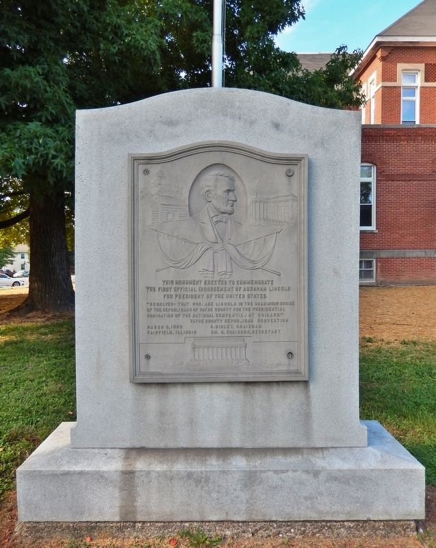
This monument erected to commemorate the first official endorsement of Abraham Lincoln for President of the United States. ”Resolved — that Hon. Abe Lincoln is the unanimous choice of the Republicans of Wayne County for the presidential nomination . . . — — Map (db m186300) HM
The country cemetery of approximately 200 graves was destroyed in the early 1950's. It was located in Lamard Township - section 24 2 miles north and ¾ mile west of Fairfield.
They had nothing but their names and now those too have been lost . . . — — Map (db m154629) HM
US Army-101st Airborne,
1st Special Forces Group (Airborne)
Recipient of:
Bronze Star
Ranger and Special Forces Tab
and all the Wayne City military veterans who have proudly served — — Map (db m242389) WM
The music for this song was composed by Jonathan Edwards Spilman in 1836. He entered the ministry in 1858 and became pastor of the First Presbyterian Church in 1881. This church had been organized by his brother Benjamin F. Spilman on November 25, . . . — — Map (db m177871) HM
This house was built by early settler John Craw prior to 1817. In 1835 it was purchased by John M. Robinson, U.S. Senator (1831-43) and Illinois Supreme Court Justice (1843). The house was later occupied by his daughter Mrs. Robert Stewart and his . . . — — Map (db m177875) HM
Colonel Everton J. Conger, who commanded the troops capturing, Abraham Lincoln's assassin, John Wilkes Booth, built this house in 1871. He practiced law in Carmi, became a Federal judge in Montana Territory, and later moved to Hawaii where he was an . . . — — Map (db m177874) HM
This building was erected in 1828 by James Ratcliff, nicknamed "Old Beaver" because of his energy. He was a founder of Carmi (1816), an inn-keeper, merchant, and postmaster, and White County's first Clerk, Recorder and Probate Judge. Abraham . . . — — Map (db m177869) HM
Alma mater of United States Senators William E. Borah, Idaho, and Wesley L. Jones, Washington. This educational institution was chartered by the Cumberland Presbyterian Church (1873). From the 1890's until 1935 it was a public school. It was . . . — — Map (db m177845) HM
In 1816 the Reverend James McGready of Kentucky organized Sharon, the first Presbyterian church in Illinois, with Peter Miller, James Mayes and James Rutledge as ruling elders. Three miles northeast of this site B.F. Spilman, active Presbyterian . . . — — Map (db m154623) HM
This church was the cradle of Methodism in White County. Early pioneers risked Indian raids to worship in the cabins of Robert Land and John Hanna. In 1812 presiding elder Peter Cartwright sent circuit rider John Smith to this settlement. This . . . — — Map (db m177839) HM
Founded in 1812 while this part of the country was still a wilderness, and before Illinois was a state, Big Prairie Church was one of the oldest Methodist churches in Illinois at the time it was closed in December 2017. Early settlers Robert . . . — — Map (db m177843) HM
The first trading post was established here in 1830 by James Gray and Robert Walden. A post office was opened here in 1836. Later, a two-story frame building was erected here by the Empire Milling Company and this corner was known as 'Empire . . . — — Map (db m61809) HM
This home was built by the Gray Family, the family that gave Grayville it's name. When completed in 1896, it was the finest home in this area and one of the first to have electric lights, running water, and steam heat. Slave quarters and a stable . . . — — Map (db m177850) HM
This building was erected in 1895 by the Gray Family for their Gray Bank on the bottom floor and the Gray Opera house on the second floor. The Opera House was the center of entertainment for many years. — — Map (db m61785) HM
In the 1830's, James Gray's Stables and Slave Quarters were located here. Later, he donated the barn to the city to use as a city hall and police station. In 1866, the city built a two story building with a jail in the basement. The second story was . . . — — Map (db m61788) HM
On this corner was located the roughest, toughest saloon in the history of Grayville. It was opened after the Civil War by Mike Smith, who made a fortune in illegal whiskey and gambling. The saloon was torched in 1881 and re-built and was finally . . . — — Map (db m177852) HM
The first Presbyterian Church in Grayville was organized in 1850 under the leadership of Mrs. Thomasann Gray. In 1868 the members built a small wooden Church on this corner of the cemetery, a gift from a member of the Gray Family.
It was . . . — — Map (db m61781) HM
Established by James R. Gray
First Internment - 1831
Obelisk Erected - 1901
Church Plaza Constructed - 2005
Memorial Plaza and Fountain Dedicated - 2007 — — Map (db m61782) HM
On this site was the home of Thomasanne Payne, Authoress of the Song 'Sleep Soldier Sleep' which she wrote in honor of James Bethel Gresham from Evansville, Indiana. He was the first American Soldier to die in World War I. The song was accepted . . . — — Map (db m61784) HM WM
On July 1, 1838, the Vincennes to Shawneetown Stage Coach Line began operations and made regular stops at a log cabin hotel located on this corner. The stage carried passengers and provided mail service for the first time in this area. — — Map (db m61787) HM
The first business in Norris City was Harper, Ritchie and Company founded in 1871 which sold general merchandise. So on, there were two Blacksmith shops, one harness shop, and one hotel. In 1904 Norris City State Bank was erected. By 1907 there . . . — — Map (db m305148) HM
As the pioneers arrived in the Norris City Area, many brought their religious customs and church preference with them and soon established their houses of worship. At first, they met in homes, but later started building log churches from the . . . — — Map (db m305232) HM
Norris City owes its existence to the railroads that crossed here, the Springfield and Illinois Southeastern was built in 1870 and 1871 and later became the Ohio and Mississippi. The Cairo and Vincennes was built through the town in 1872 and . . . — — Map (db m306286) HM
The first school in town was built in 1871 and was called The Little Red School House. It served the town until 1908, when a new school was built. It consisted of the elementary grades and 1-year high school. In 1926, a 4-year High School was . . . — — Map (db m305268) HM
The Oil Boom brought many Oil Companies to Norris City and one of the biggest was Sohio Oil Company, an American Oil producing, transporting, refining and marketing Company starting up in 1870 and lasted until 1911 when it split into Sohio and . . . — — Map (db m305229) HM
Norris City owes its existence to the railroads, which came through in 1871. Because of the railroads, Norris City was chosen for the Texas Eastern Terminal. In the early 40's, oil was shipped from Texas to other parts of the Country, but the . . . — — Map (db m305151) HM
Before the bombing of Pearl Harbor on December 7, 1941, and entry of the United States into World War II, 95 percent of the crude oil delivered to east coast oil refineries was transported by tanker ships with 90 percent of that oil from Texas . . . — — Map (db m154609) HM
A canal from Terre Haute to Evansville authorized 1846. Maysville Division along White River was over 23 miles long from Newberry through Owl Prairie (now Elnora) to Maysville; part of it paralleled what is now S.R. 57. Contracts were let June . . . — — Map (db m23203) HM
This flag continues to fly in memoriam gratitude to all community residents- kin and friend- for loyal service in the United States military.
All gave some, some gave all.
May God bless and keep them. — — Map (db m176088) WM
Born in Odon, on July 17, 1889, Joseph Crook Dawson was one of the most acclaimed “Daredevils of The Speedways”, during the formative years of auto racing in this country. His most memorable accomplishment came in 1912, when he gained . . . — — Map (db m176080) HM
Dedicated to all Odon Indiana and surrounding area veterans.
In honor and memory of our men and women in our armed forces who rendered service to our country during wartime and peacetime; at home and overseas. We must never forget those who . . . — — Map (db m99101) WM
Platted in 1846 by John Hastings; town named Clarksburg reportedly after George Rogers Clark; post office name was Clark’s Prairie, 1858-1881. Both names changed to Odon, 1881; Odon incorporated, 1885. By tradition, name Odon coined by combining . . . — — Map (db m99006) HM
Mission Revival Style depot, built 1906, restored 1990; part of Washington Commercial Historic District. Link to city's trading and industrial history, with substantial railroad machine shops and car works. Indiana stop of former President Dwight D. . . . — — Map (db m23214) HM
( Front - Center Panel )
This memorial is the tribute of the people of Daviess County to the memory of her Brave Soldiers who endured the hardships and fought the battles of 1861 to 1865 that the Union might be preserved
( Front . . . — — Map (db m23352) WM
Built on this site by civilians to protect approximately ten families during War of 1812. Named for landowner David Flora. Ten such forts were built circa 1811-1813 in area that became Daviess County. Area was Knox County, part of Indiana Territory . . . — — Map (db m23211) HM
Side A
Homer E. Capehart
Born into Indiana farming family 1897. Manufactured and pioneered sales of automatic phonographs, creating Capehart Corporation. Executive of Rudolph Wurlitzer Company 1933-1944. Organized 1938 Republican . . . — — Map (db m23206) HM
Residence of Robert C. Graham (1885-1967), pioneer glass, truck and auto manufacturer. Placed on the National Register of Historic Places in 1983 by the U.S. Department of the Interior because of its history and Prairie Style architecture. — — Map (db m23208) HM
Robert Cabel Graham (1885-1967), a native of Washington, Daviess County, with his brothers Joseph and Ray, contributed much to the economy and quality of life in that city, Evansville, and other towns. Glass factories, truck manufacturing, and . . . — — Map (db m98936) HM
In 1788 Congress granted 400 acres of land to each French family of this area. The tract was laid off in a square containing 160 separate plots. Additional grants were made affecting the five counties shown. — — Map (db m98935) HM
For several miles along these hills the improved road is built upon or within sight of the historical buffalo trail of the years prior to 1790. This trail was used by Gen. William Henry Harrison, Gen. John Tipton, Gen. John Gibson, Gen. Z.M. . . . — — Map (db m290957) HM
One of the most unique homes in Ferdinand, the Wollenmann House was built in 1903 by Ben Seufert Construction for Dr. Alois Wollenmann and his family to the good doctor's specifications. Born in Switzerland, in 1864, he wanted his home to . . . — — Map (db m289751) HM
Ida Hagan grew up in the Pinkston Settlement, a free Black community west of Ferdinand. In 1904, local physician Dr. Alois Wollenmann appointed her deputy postmaster of the Ferdinand Post Office at age 16. at a time when few professional . . . — — Map (db m289750) HM
has been placed on the National Register of Historic Places by the United States Department of the Interior May 12, 1975 Henry Mursinna, Architect — — Map (db m171498) HM
This base line was part of survey system designed to divide and organize land on a grid. Described by Land Ordinance of 1785, this method enabled U.S. government to sell land to settlers after removal of Native Americans.
U.S. . . . — — Map (db m307070) HM
( Battle Names - Around Top of Memorial )
Antietam • Chickamauga • Gettysburg • Vicksburg
( Front Panel )
Yield not to grief the tribute of a tear,
But ‘neath the fore-front of a specious sky,
Smile all exultant, as they . . . — — Map (db m47458) WM
(( Left ‘Small Book’ ))
( Left ‘Page’ )
* * * Mexican War * * *
James Green • Pleasant Horton • James McElvaine • Hiram Main • David L. Matthews • Joseph Orinder
* * * Spanish American War * * *
Jesse K. Stork . . . — — Map (db m47497) WM
Settling at Vincennes about 1780, Toussaint Dubois, a friend of William Henry Harrison, became a merchant, trader with Native Americans, soldier, and politician. His holdings included a land tract purchased from the United States Government on May . . . — — Map (db m195491) HM
In 1860 the Alles Furniture Store was established here. This later became the Jasper Furniture Co., predecessor of the Jasper Desk Co., which was formally established in 1876 at another location. — — Map (db m195444) HM
Capt. Richard Stillwell Hugh Rodman James Harbison Luther Adams Lewis Powers John Hills William Anderson Placed by Dubois County Chapter Daughters of the American Revolution 1935 — — Map (db m195481) HM
From 1830 until it burned in 1839, a log building on this site served as the first Court house in Jasper and as the first school, which was taught by Simon Morgan, the County Clerk. — — Map (db m47410) HM
Increased crime during the Great Depression demanded an expanded police presence and faster communication technology. In response, the Motor Vehicle Police (established in 1921) was reorganized as the Indiana State Police in 1933. The new division . . . — — Map (db m238483) HM
( At Top - - Canal Map & Points of Interest )
Here is a section of the Wabash & Erie Canal still visible in Gibson County. Construction of the approx. 460 mi. canal. The longest in North America. Began in 1832 & was completed in 1853. One . . . — — Map (db m47806) HM
Established 1840 A Historic Cemetery Listed In Indiana's Cemetery and Burial Grounds Registry of The Indiana Department of Natural Resources — — Map (db m63745) HM
Side 'One'
Born 1799 in North Carolina. Purchased land 1818 in Gibson County. Cockrum and Jacob Warrick Hargrove laid out the town of Oakland (now Oakland City) on January 15, 1856. Cockrum and his son William Monroe Cockrum, along with . . . — — Map (db m47807) HM
Decorated soldier Aaron Fisher was born at Lyles Station and joined the U.S. Army at age 15. He was assigned to the 9th Cavalry and later the 24th Infantry, both historic Buffalo Soldier units, and served in the Southwest and in the Mexican . . . — — Map (db m285507) HM
Princeton abounds in fertile soils from the seasonal flooding of the Wabash, Patoka & White Rivers. Fertile silts were deposited in the riverbeds by glacial outwash at the end of the last glacial period. Archeological records indicate that Native . . . — — Map (db m190588) HM
By 1862, the Union Army’s need for new recruits could no longer be met by volunteers; in March 1863, U.S. Congress passed the Enrollment Act authorizing a national draft. Drafted or enrolled men of means could hire substitutes to serve in their . . . — — Map (db m238485) HM
( 1864 Monument )
Erected
by the Survivors of
the 58th Reg. Ind. Vol.
To the memory of
their deceased comrades
in arms
1864
Honor the Flag
( 1914 Bronze Plaque )
This monument was erected by the 58th . . . — — Map (db m48100) WM
During the Carboniferous Period between 359 & 299 million years ago, Princeton had a much warmer climate than it does today, & the landscape was covered by giant plants. The buried remains of these plants were transformed into coal over millions of . . . — — Map (db m190598) HM
The site of the town of Princeton was chosen as the county seat in 1814 by county commissioners William Prince, Robert Elliott, Abel Westfall, and William Polk. On February 14, 1814, the name Princeton was chosen by the commissioners, casting lots . . . — — Map (db m190739) HM
Structures on State, Broadway, Water, Hart, and Main Streets comprise the Courthouse Square Historic District. Commercial development on the courthouse square resulted in part from Princeton's position as a transportation center for the area. In . . . — — Map (db m190738) HM
WHEREAS, the citizens of the City/County of Princeton, Gibson County, Indiana, USA and Tahara-cho, Japan do mutually agree to establish a Friendship city/county affiliation to deepen the friendship and confidence between our countries and to . . . — — Map (db m190737) HM
Immigration to the Princeton area began to explode after the Northwest Territory was formed in 1787. Young settlers came seeking a place to start their own homestead. They often arrived by way of the Red Bank Trail & Patoka Trace, traveling either . . . — — Map (db m190587) HM
Soldiers & Patriots of the
American Revolution
buried in Gibson County Indiana
( Row One )
Robert Archer, S. C. • Thomas Bell, S. C. • Nicholas Boren, Penn. • David Bucklin, R. I. • Robert Cashbott, Penn. • Charles Cross, Va. • . . . — — Map (db m47895) WM
Dedicated to All
Gibson County service
Men and Women that
served in Desert Storm
and Desert Shield in
support or in combat
from Aug. 1990 — Mar. 1991
( Obverse Side )
Erected by
Gibson Navy Mothers . . . — — Map (db m47874) WM
( Center Panel )
“They have earned the undying esteem and respect of all thoughtful and freedom-loving Americans for their overriding devotion and sense of duty to our Nation.”
— President Ronald Reagan — . . . — — Map (db m48224) WM
(( Center Panel ))
Erected by the Service Mother
( Across Both Side Panels )
In Commemoration of the Valor and
Sacrifice of our Heroes in World Wars I and II
(( Left Panel ))
( Row One )
Charles T. Alvis . . . — — Map (db m48101) WM
Born in Princeton, Dodgers first baseman Gil Hodges grew up in Petersburg. In 1941, he played American Legion baseball here. The field was renamed for him in 1970. Hodges debuted with MLB's Brooklyn Dodgers in 1943 but served with the U.S. Marine . . . — — Map (db m285517) HM
Princeton's natural resources & its location at a transportation crossroads has allowed it to thrive as a hub of industry for over 200 years. In the early 1800s, as pioneers arrived, tradesmen such as blacksmiths & carpenters were quick to set up . . . — — Map (db m190599) HM
Erected 1914
Centennial Year
by
General John Gibson
Chapter Daughters
of the
American Revolution
in Honor of
Judge William Prince
after whom Princeton
was Named — — Map (db m47873) HM
The legacy of Lyles Station, a small community located 4.5 miles west of Princeton, Indiana, began in the early 1800’s as a settlement of free black men near the convergence of the Wabash, Patoka & White Rivers. In 1870 Joshua Lyles, a free black . . . — — Map (db m190600) HM
Settled in late 1840s by Joshua and Sanford Lyles, former slaves from Tennessee. African Methodist Episcopal Church (since 1860) and schools (1865-1958) played important roles in sustaining the community. On land donated by Joshua Lyles, . . . — — Map (db m47805) HM
1886 --- Lyles Station, Indiana --- 1986
Dedicated to preserve the memory of Joshua Lyles
Lyles Station, Indiana, the State’s only remaining black-named community, was settled more than one hundred years ago by Joshua Lyles, a Freed . . . — — Map (db m47898) HM
Many Native American tribes have inhabited the Princeton area over the centuries, including the Piankeshaw, Wea, Shawnee, Deleware, Sac, Fox, Kickapoo, Miami & Pottawatomi tribes. These peoples fished the area's rivers & streams, hunted for buffalo, . . . — — Map (db m207981) HM
The residential neighborhood surrounding North Main Street has over a dozen homes in varying architectural styles built during the historical development period of 1845 to 1930. Two homes are of particular note. A two-story domestic residence . . . — — Map (db m285533) HM
Shaped by the last retreating glacier around 10,000 years ago, the Patoka River meanders through sand, gravel & silt deposits left by glacial outwash. The river corridor is home to over 380 species of wildlife, including nesting bald eagles, the . . . — — Map (db m190735) HM
The Princeton you see today is not as it always was. Over billions of years, natural processes have drastically affected the climate, flora & fauna, & even the geographic location of what is now Princeton. Between 420 & 359 million years ago, during . . . — — Map (db m190585) HM
Gibson County was formed in 1813 from the southwestern portion of the Indiana Territory. Once the wheels of county government began turning, the push to locate a county seat was imminent. The settlement of Patoka had been selected for the seat, but . . . — — Map (db m190591) HM
In the late 1840s, Samuel Hall, future president of the Evansville & Illinois Railroad Co., had a vision of bringing the railroad to his adopted town of Princeton. He devoted much time & resources to realize his vision, but success did not come . . . — — Map (db m190592) HM
2014 marks the Bicentennial Celebration of Princeton, along with a period of great civic improvements. Princeton's mission statement is, "To provide residents, visitors & the business community with the highest quality municipal services in an . . . — — Map (db m190736) HM
On Wednesday, March 18, 1925 at 4:15 p.m. a tornado ripped through the city of Princeton. In the 60 seconds it took to pass through town, hundreds of people lost everything they owned, & many lost their lives. The tornado was rated an F-5 & named . . . — — Map (db m190734) HM
After devastating parts of Missouri and Illinois, the Tri-State Tornado crossed the Wabash River and entered southern Indiana on its 219-mile path. The tornado destroyed the town of Griffin and caused massive damage to Owensville before hitting . . . — — Map (db m285508) HM
The Brownlee Addition Historic District is located along West Spruce and
West Walnut Streets between North West Street and Brownlee Avenue. Most
of this district was originally owned by Robert W. Evans. On April 15, 1828
Judge Samuel Hall, who . . . — — Map (db m226445) HM
The South Princeton Historic District is a three-block area of predominately
residential structures. This district is located on South Hart, South Main, and
West Water Streets just south of the courthouse square. A broad range of
architectural . . . — — Map (db m226489) HM
First settlement, 1808-1812,
of a religious society of
celibates known as Shakers.
The four hundred members
of this communal group
occupied 1,300 acres seven
miles west of Carlisle. — — Map (db m226327) HM
Welcome to
"Grouseland"
Built 1803 - 1804
Home of
William Henry Harrison
Governor Indiana Territory 1800 - 1812
President of the United States 1840
Mansion owned and restored by
Francis Vigo Chapter
Daughters of the . . . — — Map (db m167023) HM
Site of print shop where Elihu Stout (1782 - 1860), Past Grand Master of Masons in Indiana, established Indiana Territory's first newspaper, summer 1804. Originally The Indiana Gazette, it was renamed The Western Sun July 4, 1807. — — Map (db m23277) HM
"One of America's Clowns"
Comedian Richard "Red" Skelton was born here in 1913. As a teenager, performed locally in minstrel shows and as a clown in circus. By 1930s he performed on vaudeville stages; became famous for skits such as . . . — — Map (db m177921) HM
The 2S1 Gvozdika is a Russian-made 122mm self-propelled howitzer tracked armored vehicle. The first prototype was ready in 1969. The 2S1 entered service with the Soviet Army in the early 1970s and was first seen in public at a Polish Army parade in . . . — — Map (db m180843) HM
The 3"/50 caliber gun (Mark 2) was an early model manufactured by General Motors with a projectile velocity of 2,100 feet per second. Low-angle mountings for this gun had a range of 7000 yards at the maximum elevation of 15 degrees. By World War . . . — — Map (db m180816) HM
The Wabash River has long been a powerful force of nature, capable of causing damage and leaving devastation in the wake of its unpredictable meanderings. This held true in 1778 for Lt. Governor Henry Hamilton of the British forces and the colonial . . . — — Map (db m260281) HM
Legend has it that over one hundred years ago, a young Richard Skelton was selling newspapers in downtown Vincennes in front of the Pantheon Theatre when a well-dressed man asked if he was planning to go to the show that evening. The boy said no, . . . — — Map (db m285583) HM
744 entries matched your criteria. Entries 101 through 200 are listed above. ⊲ Previous 100 — Next 100 ⊳