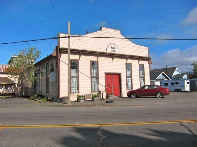
This site, originally R.A. Simpson's Ferndale Mechanical Shop, and shared by A. Monroe Cider and Vinegar Company, was chosen in 1904 by Aage Jensen as the founding location of the Central Creamery with first production of butter in September, . . . — — Map (db m65235) HM
Solvang California
The Danish Capital of America
The settlement of this unique Danish American colony came about with the establishment of a Danish folk school, Atterdag College and a church for the study of Danish heritage.
This . . . — — Map (db m310380) HM
Gold was discovered on the slope of Rand Mountain in 1895. From this discovery, the town of Randsburg sprang up almost overnight. By 1899, the town had over 3500 residents. Randsburg boasted a 100-stamp mill and conservative estimates are that . . . — — Map (db m78578) HM
This plaque and garden are dedicated to the memory of the first peoples who lived in what is now the County of Los Angeles. Some of the earliest Indians were members of the Uto Aztecan linguistic family or were descended from the Shoshone Tribe. . . . — — Map (db m54552) HM
Completion of the Sacramento Valley Railroad from Sacramento to Folsom was completed here February 22, 1856, by enthusiastic residents of both cities. The new line, 22 miles in length was commenced February 12, 1855, and was built by Theodore . . . — — Map (db m15613) HM
California gained statehood on September 8, 1850. It did so comprised of 27 counties with this area a part of Yuba County.
“The disadvantages of belonging to Yuba County were early felt; Marysville was too distant and a county government . . . — — Map (db m43846) HM
The Nevada-California-Oregon Railway, a three foot narrow gauge, reached the Southern end of Alturas in 1908.
The Reno based contractor, Martin and Diamond, was hired to construct the passenger depot out of native stone.
Construction was completed . . . — — Map (db m284478) HM
Welcome to Rancho Camulos, a National Historic Landmark. Ygnacio del
Valle established Rancho Camulos and began building his adobe home
here in 1853 on what was part of a 48,000-acre Mexican land grant
awarded to his father. Originally a . . . — — Map (db m220575) HM
Trojan Cardinal And Olympic Gold
Among the scholars who have passed
through the University of Southern California have been thousands of star athletes:
All-American football players, Hall of Fame
standouts, a future Oscar winning . . . — — Map (db m238532) HM
The emigrant train of Forty-Niners, 5,000 strong, set out from Fort Smith in April, 1849, with an escort of United States [Army] Regulars under the command of Captain R. B. Marcy. — — Map (db m92353) HM
In Memory of the victims of September 11, 2001 and in honor of our fallen heroes
America's bravest - New York City Firefighters
Port Authority of NY and NY Police Officers
America's Finest - New York City Police Officers
The Passengers . . . — — Map (db m114526) WM
In honor of the sesquincentennial of the Mariposa County Courthouse and recognition of its continuous use since 1855.
In June 1857 Biddle Boggs vs. Merced Mining Company made legal mining history and the 1861 cases of Moore vs. Smaw and Fremont . . . — — Map (db m46739) HM
From 1901 to 1941, much of the eastern portion of Cannery Row’s coastline was occupied by a single estate, Casa de Las Olas, which stretched 1,000 feet along Monterey Bay (top). San Francisco financier Hugh Tevis had it built in 1901 as a wedding . . . — — Map (db m55212) HM
The Santa Ana Mountains, which encompass the canyons of Silverado, Modjeska and Trabuco, provided one of the last refuges for the state symbol, the Grizzly Bear.
At the turn of the century, beekeeping was an important local industry, providing . . . — — Map (db m78516) HM
Training troops in desert warfare in preparation for Operation "Torch." The invasion of German held North Africa. The world's largest military installation, training 60 divisions and more than one million soldiers. — — Map (db m99284) HM
Natomas Company activities started in this area in 1857 with the acquisition of 9,000 acres from the Joseph L. Folsom estate.
Early partners engaged in water, granite quarrying, agriculture, vineyards, gold mining, hydro-electric power and . . . — — Map (db m705) HM
In memory of the American Servicemen of Hispanic descent and all others who sacrificed their lives to protect the freedoms we enjoy. — — Map (db m15474) HM
Formerly one of the grandest Harvey House Hotel, Restaurant & Santa Fe Train Stations. The hotel and restaurant were open from 1908 to 1949. The train station closed in 1988.
Recognized by Hampton Hotels Save-A-Landmark program as a site . . . — — Map (db m33445) HM
Built in 1945, this park continues to provide a center reminiscent of early Mexican Heritage.
Recognized by Hampton Hotels Save-A-Landmark program as a site worth seeing. — — Map (db m204524) HM
was established just west across what is now U.S. 99 by C.C. Fugitt in 1852. It was first known as Davis Crossing, then Fugitt's and finally Liberty in 1859. By 1869 Liberty was an important stage stop between Stockton and Sacramento. During its . . . — — Map (db m178004) HM
This was a public plaza in the Mezesville townsite, and was a park until 1959 when it was given to San Mateo County for a Hall of Justice and Records. — — Map (db m62577) HM
Located east of the Cascade Mountain Range where the old Topsy Grade Stage Road enters Butte Valley, the town of Picard was settled in the early 1880s. Picard's Post Office opened in 1883 and closed in 1907. La Lake School located one mile to the . . . — — Map (db m100220) HM
"We enter a gorge of the hills which in a short time brings us to a large ampitheatre surrounded with rock of every kind of fanciful character." -- Joseph Middleton Aug 26, 1849 Guidebook Available
Trails West Inc. P.O. Box 12045, Reno . . . — — Map (db m123955) HM
"A ride ... brought us to the outlet of this romantic vale, a very narrow pass - just wide enough for a wagon, and on either side very high, jagged and thin walls of granite ... called the 'Pinnacle Pass'" - J.G. Bruff, Aug 29, 1849
. . . — — Map (db m123990) HM
"The gray granit rocks stand in pyramid monument & dome forms., here & there towering aloft. The road winds along between them. Emigrants names are written ... on these curious structures" -- Augustus Ripley Burbank, Aug 4, 1849 Guidebook . . . — — Map (db m123987) HM
"After crossing (Cassia Creek) we crossed a swamp, which required considerable persevering to get through safely. Three miles farther we encamped on the side of a hill, between two ranges of mountains" -- Wakeman Bryarly, Jul 18, 1849
. . . — — Map (db m123883) HM
"We came onto the Subetts Cut Off road (Hudspeth Cutoff), or rather that cut off come onto our road which is the old and longest road." -- Henry Anable, Aug 7, 1852
Guidebook Available
Trails West Inc. P.O. Box 12045, Reno NV . . . — — Map (db m123882) HM
"The moon just rising above the mountains, throwing mild light over the valley & opposite mountain, formed a beautiful scene of prairie mountain life." -- Hugh Brown Heiskell, Sep 3, 1849
Guidebook Available
Trails West Inc. P.O. Box . . . — — Map (db m124026) HM
The present three story building was designed by August Foell and constructed for Henry W. Heuermann in 1894. Heuermann occupied the north portion as a dry goods store for several years. On January 14, 1908, Heuerman received a permit to remodel . . . — — Map (db m196100) HM
"We have to cross the river four times... on each side of you there is a perpendicular wall of vast rock... overhanging the road so one has a feeling very near bordering on fear as he passes under those precipices" -- Lewis Beers, Aug 3, 1852 — — Map (db m149731) HM
"The road still continues on the south side of the river, there is also one on the north side and I believe it is the old one. The one on the south side is said to be the best." - Joseph Middleton, Sep 18, 1849
Guidebook available
Trails . . . — — Map (db m138455) HM
"Grass the best I ever saw. Better than any meadow in the
states. There are a large number of campers around us all
cutting grass with sythis" - William R. Brown, Sep 7, 1853
M.E.0. 1996
Guidebook available
Trails West Inc. P.O. Box . . . — — Map (db m263865) HM
“Passed down the valley near the slough... the slough water
is considerably impregnated with alkali, but is used for
animals & all other purposes.... No good water below this
slough, nor grass.” - Augustus Ripley Burbank, Aug 30, 1849
. . . — — Map (db m263930) HM
A major steamboat building center on the Monongahela, 1852-1879. No fewer than 131 boats were constructed here (74 in the 1850s alone), primarily for the western river trade. The boatyards ceased operations when the railroad (PV and C) acquired the . . . — — Map (db m41783) HM
One of Texas' first cross-country wagon trails. The San Antonio-El Paso section of this route was surveyed in 1848 by a party under the intrepid Indian fighter Jack Hays. Used first by emigrants and gold-seekers, it became part of the San . . . — — Map (db m73317) HM
In the middle and late 1800’s, wagon trains carrying settlers and freight covered vast southwestern landscapes that often resembled "Seas of Grass." The most popular wagons, built in the Pennsylvania towns of Conestoga and Pittsburgh, featured . . . — — Map (db m308661) HM
One thousand competitors from 34 nations came to Squaw Valley to compete in the VIII Olympic Winter Games of 1960. The Games, brought here by Alexander C. Cushing, commemorated a century of sport skiing in America. By 1860 mining towns in the Sierra . . . — — Map (db m23504) HM
This trail was blazed by Peter Burnett in 1848 from Oregon City, Oregon Territory to the California gold fields. The route followed the Applegate Trail south and eastward to Tule Lake. It then struck southward probably following an earlier trail . . . — — Map (db m147839) HM
The mill was constructed in the 1830's by John Reed and was one of the first saw mills in Northern California.
The mill site was utilized in May 1890 to conduct a public land auction of land parcels that signaled the founding of the City of Mill . . . — — Map (db m143523) HM
This section of a column from the legendary Troy, quarried and polished without the aid of iron tools at an unknown date before 1200 B.C., stood in the courtyard of a public building believed to have been a temple of Trojan Apollo. It was presented . . . — — Map (db m130174) HM
Alfred 'Al' Zampa was the first born son of Emilio and Maria Zampa, Italian immigrants who migrated to the USA from Abruzzi, Italy. Al was born on March 12, 1905 in Selby, California down river from where this plaque sits. He was the eldest of three . . . — — Map (db m91658) HM
Established here July 29, 1879, to the Glory of GOD and to the Preservation of the Republic.
An institution of higher learning dedicated to the search for and the dissemination of the truth to freedom of thought and discussion. To intelligent, . . . — — Map (db m130534) HM
Combat Veterans Wounded-My stone is red for the blood they shed. The medal I bear is my country’s way to show they care. If I could be seen by all mankind maybe peace will come in my lifetime. — — Map (db m104604) WM
On this site stands CSO-4 (Pico #4), California's first commerically productive well. It was spudded in early 1876, under the direction of Demetrius G. Scofield, later to become first president of Standard Oil Company of California, and was . . . — — Map (db m157684) HM
Birthplace of Union Oil Company of California. Founded October 17, 1890. Presented by the City of Santa Paula, California, to Union Oil Company of California, in commemoration of the company's 50 years of service to the West, August Twenty-Four, . . . — — Map (db m154493) HM
From 1885 to the end of his life his home stood about fifty yards east of this spot
"He who is a blessing for his time is a blessing for all time" — — Map (db m174416) HM
Heavy freight wagons lumbering to and from New Mexico, and emigrant families and gold seekers heading west to Oregon and California all shared this route from Independence and Kansas City. The trails split here at Gardner Junction.
Preserving . . . — — Map (db m131353) HM
From the late 1820s to the 1870s, an estimated 300,000 fur traders, missionaries, settlers, and gold seekers followed these trails. In the 1840s and 1850s, emigrants from the eastern and central United States walked 2,000 miles from the Missouri . . . — — Map (db m131376) HM
Birthplace of Freemasonry in California.
Historical Landmark No. 408.
second marker:
This site marks the birthplace of
Freemasonry in California.
At this location on October 17, 1849
the first meeting of
Free and . . . — — Map (db m240302) HM
Near here in May 1867, the California Petroleum Company brought in "Ojai No. 6" at a depth of 550 feet. W.W. Orcutt described it as "The first well drilled for oil in California that yielded extended commercial production." It was the first . . . — — Map (db m202604) HM
Back From the Brink of Extinction
Half a million tule elk once roamed
the marshes and grasslands of
California. The Gold Rush began an
era of commercial hunting and
agricultural practices that decimated
the elk and their . . . — — Map (db m184928) HM
In the spring of 1852, Augustus T. Dowd, while hunting, discovered a grove of truly immense trees, now known as the Calaveras North Grove. Several stockholders of the Union Water Company (who employed Augustus as a hunter) developed a plan to . . . — — Map (db m34120) HM
In the early 19th century what is today the northwest coast of Washington State might have become a Russian colony, an extension of Alaska, if the Sv. Nikolai voyage had been successful. This could have led to this section of New Albion, the . . . — — Map (db m129579) HM
As part of Spain’s imperial road system, El Camino Real connected the missions in Alta (Upper) California, from San Diego to San Francisco and Sonoma. The Royal Road was the heart of keeping the missions supplied with goods and people, as the . . . — — Map (db m236037) HM
In 1811 the first white expedition to go through this area of the Snake River and the lower end of the Raft River Valley was the Wilson Price Hunt expedition from St. Louis to Astoria. However, the area was well known to the French and British . . . — — Map (db m123843) HM
Heisler Locomotive, built by Stearns Manufacturing Company, 1899.
Shay Locomotive, built by Lima Locomotive Works, 1912.
Climax Locomotive, built by Climax Manufacturing Company, 1928.
The Shay locomotive, patented in 1881, and its two . . . — — Map (db m190694) HM
Honoring
Four Early Americans in California
They came to this coast as seamen and remained as settlers
Baptized in this Mission
George Mayo, of Plymouth, Mass., on 3 August, 1816
Thomas W. Doak, of Boston, Mass., on 22 November, 1816 . . . — — Map (db m63684) HM
In 1842 John R. Wolfskill arrived here loaded with fruit seeds and cuttings. He was a true horticulturist and became the father of the fruit industry in this region. In 1937 Mrs. Frances Wolfskill Taylor Wilson, his daughter, bequeathed 107.28 . . . — — Map (db m40132) HM
The gentleman upon this rock is Count Agoston Haraszthy, the Hungarian nobleman who founded Buena Vista Winery in 1857. He is now known as the Father of California Viniculture - as he did more than any other single person to create our remarkably . . . — — Map (db m207724) HM
The Santa Fe Trail began in 1821 when William Becknell took trade items west and found a ready market in Mexico. He passed through this area before the village of Independence was platted in 1827 as the county seat for newly formed Jackson County. . . . — — Map (db m208242) HM
This mining town became the seat of justice of Mariposa County when on February 18, 1850, the State Legislature divided the state into 27 original counties. Mariposa County then comprised one fifth of the entire state and included what now are . . . — — Map (db m299230) HM
The D.T.C was established by Major General George S. Patton Jr. in response to a need to train American combat troops for battle in North Africa during World War II. The camp, which began operation in 1942 covered 18,000 square miles. It was the . . . — — Map (db m50700) HM
Being at leisure one day, I rode over to Independence [from Westport, in May 1846]. The town was crowded. A multitude of shops had sprang up to furnish the emigrants and Santa Fe traders with necessaries for the journey; and there was an . . . — — Map (db m208146) HM
People on steamboats loaded with goods traveled upstream on the Missouri River "highway" to Independence, where the overland journey on the Santa Fe, Oregon, and California trails began. Between March and November, steamboats passed by or stopped . . . — — Map (db m208241) HM
Built in 2009, Chaparral Hall is named after the most dominant
natural vegetation type in Southern California, and is home to the
Biology Department in the College of Science and Mathematics.
Chaparral Hall's 13 "smart" lecture rooms can seat a . . . — — Map (db m220300) HM
Camps Hyder & Horn were established 10 miles north of Dateland in the fall of 1943. They were 2 of 15 desert camps built to harden and train United States Troops for service in World War II. The Desert Training Center was a simulated theater of . . . — — Map (db m78546) HM
On this site the flag of our country
was raised on September 24, 1956, signaling the
beginning of classes for the Valley campus
of Los Angeles State College, which became
San Fernando Valley State College July 1, 1958,
and California State . . . — — Map (db m208634) HM
The grove's more than 400 orange trees serve as one of the
last vestiges of the San Fernando Valley's agricultural history.
Harvested fruit is regularly donated to local food banks.
The grove has been transformed into a welcoming retreat
with . . . — — Map (db m208641) HM
Hiram Young came to Missouri as an enslaved African American. He earned his freedom step by step. First he purchased his wife Matilda's freedom in the early 1840s. For children to be free, they had to be born to a free mother. The Youngs welcomed . . . — — Map (db m208243) HM
Gilman Hall was built in 1916-17 to accommodate an expanded College of Chemistry under the leadership of Gilbert Newton Lewis. This building provided research laboratories and teaching facilities for faculty and students specializing in physical, . . . — — Map (db m15870) HM
Physical Education Building,
University of Southern California,
erected 1930.
Rufus B. Von Kleinsmid,
president of the university.
William Ralph La Porte,
director of the Division of Physical Education.
Building committee:
Charles E. . . . — — Map (db m230110) HM
When the college opened in 1961, the chicken coops located on the Pederson ranch were converted for campus use. F Building housed the campus coffee shop, which doubled as the cafeteria, and a full soda fountain, E Building served as the library; D . . . — — Map (db m154417) HM
At this site on the old Clarksville-White Rock Emigrant Road was Mormon Tavern. Constructed in 1849, this popular stage stop was enlarged and operated by Franklin Winchell in 1851. It became a remount station of the Central Overland Pony Express and . . . — — Map (db m12056) HM
Because a superior faculty is at the heart of
any university's stature, USC has long been
committed to attracting the best and the
brightest men and women to teach its students. During
its early years, the university's growing . . . — — Map (db m234141) HM
One mile north of here on May 1, 1776, Francisco Garces of the Franciscan Order, crossed Kern River in his search for a shorter route from Sonora, Mexico to Monterey, California. He was the first known explorer to describe this river, which he . . . — — Map (db m24984) HM
From 1853 until 1870 Keyesville was a center of both placer and quartz gold mining. On the knoll just below the townsite may still be seen the outlines of an earth-work fort, built to meet a possible Indian attack in 1863. The original Keys Mine is . . . — — Map (db m143331) HM
The 166,000 sq. ft. state-of-the-art performing arts center opened
in 2011 and features an acoustically tunable 1,700 seat
performance hall, 180 seat flexible theatre, and academic lab and
lecture spaces. The building incorporates reflective . . . — — Map (db m220284) HM
Here, along Arroyo de los Alamitos Creek in 1824, Luís Cabolla and Antonio Suñol first worked New Almaden ore in an arrastra. In constant production since 1845, more than a million flasks of quicksilver valued at over 50 million dollars have been . . . — — Map (db m18692) HM
The entire country had railroad fever in the 1830s, with the dream that one day a railroad might span the continent! In Independence merchants needed to move goods between the town square and the Wayne City steamboat landing on the Missouri River - . . . — — Map (db m208135) HM
As the first federally funded road built west of the Mississippi, the Lander Road played an important role in emigrant travel. Beginning in 1859, emigrants used this 256-mile alternate route. This saved them up to seven days of travel, bypassed . . . — — Map (db m314935) HM
Hydraulic Mining was the largest and most destructive form of mining. Water, brought through flumes and ditches from high up in the mountains, was redirected into an ever-narrowing channel and out through a giant iron nozzle, called a . . . — — Map (db m56649) HM
This unit, affectionately called a "covered wagon" was purchased to power Western Pacific's California Zephyr less than one year after the train began on March 20, 1949. This cab unit, typically joined by two cabless "B" units, hauled the train . . . — — Map (db m163295) HM
Erected 1850, the original structure was destroyed by fire in 1870, and rebuilt in 1871 by the citizens of Smartsville on the original foundation. At one time this church served 800 parishioners, mostly Irish Catholics employed at the Smartsville . . . — — Map (db m39828) HM
This boulder erected November 12, 1932 by Court San Diego de Alcalá, No. 1099 of the Catholic Daughters of America, to commemorate the first Holy Mass celebrated in California, November 12, 1602 upon the arrival on this site of Sebastián Vizcaíno . . . — — Map (db m81238) HM
To Commemorate the introduction of the first Marsh Grapefruit Trees into California, brought to Riverside from Lakeland, Florida in 1890 by Twogood and Cutter, pioneer nurserymen, and to honor J.E. Cutter who planted here one of those first . . . — — Map (db m82144) HM
c.1835 • One-story adobe built by José Manuel Machado, a
corporal at the presidio.
1845 • Jack Stewart, a carpenter by trade, married youngest
daughter Rose and moved in with the family.
1911 • Home completely remodeled.
1932 • . . . — — Map (db m239780) HM
The Ascent of Humanity, created by Allan Cottrill of Washington, Pennsylvania, was unveiled after commencement on May 4, 1996. The sculpture consists of fifteen human figures in bonded bronze, each one eight to ten feet tall, ascending two adjoining . . . — — Map (db m201230) HM
This building, built in 1951, was purchased by Ramona Parlor No.109
Native Sons of the Golden West in 1998 and renovated as a meeting
hall and a place to display their early California artifacts in their efforts to preserve the “Spirit of . . . — — Map (db m124459) HM
This mining town became the seat of justice of Mariposa
county when on February 18, 1850, the state legislature divided
the state into 27 original counties.
Mariposa county then comprised of one-fifth of the entire
state and included . . . — — Map (db m307541) HM
8928 entries matched your criteria. Entries 201 through 300 are listed above. ⊲ Previous 100 — Next 100 ⊳
Thin black lines indicate changes in relevance. Between each pair of lines entries are ordered geographically but all have the same relevance.
* Inflectional forms of words are their plurals, singulars, and possessives as well as gramatical tenses and similar variations.