By Karen Key, October 8, 2006
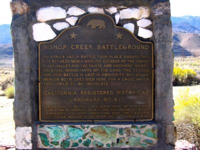
Bishop Creek Battleground Marker
| On East Bishop Creek Road south of California Route 168, on the left when traveling south. |
| Near Silver Canyon Road east of U.S. 6. |
| On Highway 6 (U.S. 6) at Silver Canyon Road, on the right when traveling east on Highway 6. |
| On West Line Road (California Route 168) west of Muny Road, on the right when traveling west. |
| Near no nearby street 1 mile east of U.S. 395, on the left when traveling east. Reported missing. |
| On U.S. 395 at and an un-named dirt road, on the left when traveling south on U.S. 395. |
| On West Side Road 16 miles south of Badwater Road, on the left when traveling south. |
| On U.S. 190, on the right when traveling east. |
| On California Route 190 at Badwater Road, on the right when traveling west on California Route 190. |
| On California Route 190 at Cottonwood Canyon Road, on the right when traveling east on California Route 190. |
| On California Route 190 at Borax Mill Road, on the left when traveling north on California Route 190. |
| On Stovepipe Wells Road 0.8 miles west of Scotty's Castle Road, on the right when traveling west. |
| On Shabbell Lane 0.3 miles north of U.S. 395, on the right when traveling north. |
| On Market Street at Webster Street, on the right when traveling west on Market Street. |
| On Highway 395 south of Bush Street, on the right when traveling south. |
| Near Manzanar Reward Road west of U.S. 395. |
| Near California Route 136 9.6 miles east of U.S. 395, on the right when traveling east. |
| Near U.S. 395 0.1 miles south of Pangborne Lane, on the right when traveling south. |
| On California Route 190 at Fall Road, on the left when traveling north on California Route 190. |
| On Trona Wildrose Road just north of Valley Wells Road, on the right when traveling north. |
| Near Bear Mountain Boulevard. |
| On Truxtun Avenue at Chester Avenue, on the right when traveling east on Truxtun Avenue. |
| On Round Mountain Road 0.8 miles east of China Grade Loop, on the right when traveling east. |
| On North Chester Avenue at Golden State Highway ( Route 204), in the median on North Chester Avenue. |
| On China Grade Loop, on the right when traveling south. |
| On West Columbus Street at Isla Verde Street, on the right when traveling west on West Columbus Street. |
| On Panama Road 0.7 miles east of Cottonwood Road, on the right when traveling east. |
| Near R Street north of 19th Street. Reported missing. |
| On Bakersfield-Glennville/Granite Road at Round Mountain Road, on the left when traveling south on Bakersfield-Glennville/Granite Road. |
| On Kern Canyon Road (State Highway 178), on the left when traveling east. |
| On Buttonwillow Drive 0.5 miles north of Highway 58, on the left when traveling north. |
| On Bealville Road 0.8 miles north of Route 58, on the right when traveling north. |
| On Bealville Road, on the right when traveling east. |
| On Bena Road at Towerline Road, on the right when traveling east on Bena Road. Reported missing. |
| On Mocal Road 1.2 miles west of Highway 33, on the right when traveling west. |
| On Garlock Road 1 mile north of Red Rock Randsburg Road. |
| On Evans Road (State Highway 155), on the left when traveling west. |
| On Jacks Valley Road at White River Road, on the right when traveling west on Jacks Valley Road. |
| On Grapevine Road West near Interstate 5. |
| On Grapevine Road West near Interstate 5, on the right when traveling north. |
| On Caliente-Bodfish Road (County Route 483), on the right when traveling north. |
| On Isabella Walker Pass Road (State Highway 178 at milepost 88), on the right when traveling west. Reported missing. |
| On State Highway 14 2 miles north of Inyokern Road, on the left when traveling north. |
| Near Woodford-Tehachapi Road 0.5 miles east of Keene, on the left when traveling east. |
| Near Wofford Heights Boulevard near Burlando Road (County Road 495), on the right. |
| On California Route 178, on the left when traveling east. |
| On Keyesville Road 2 miles west of Highway 155, on the right when traveling west. |
| On Lebec Road just west of Interstate 5, on the right when traveling south. |
| On Fort Tejon Road west of Interstate 5. |
| On Petroleum Club Road 0.5 miles north of Kerto Road, on the left when traveling north. |
| On Lokern Road at Westside Highway (County Route 33), on the right when traveling west on Lokern Road. |
| On State Highway 58 at State Highway 33, on the left when traveling west on State Highway 58. |
| On Maricopa Highway (State Highway 166) 3.7 miles west of Interstate 5, on the right when traveling west. |
| On David Road at North Wheeler Ridge Road, on the right when traveling east on David Road. |
| On California Route 14 north of Nadeau Street, on the right when traveling north. |
| On Isabella Walker Pass Road (State Highway 178 at milepost 79.8), on the right when traveling east. |
| On Butte Avenue just east of Highland Avenue, on the right when traveling east. |
| On Manly Road 0.4 miles north of Truman Road, on the right when traveling north. |
| On Manly Road 0.2 miles north of Truman Road, on the left when traveling north. |
| On Shafter Avenue north of Merced Avenue, on the right when traveling south. |
| On Vultee Street at East Lerdo Highway on Vultee Street. |
| Near Lake Station Road 2.7 miles north of Gardner Field Road. |
| On Old Town Road at Woodford Tehachapi Road, on the right when traveling north on Old Town Road. |
| On Tehachapi-Willow Springs Road, on the right when traveling north. |
| On Woodford-Tehachapi Road, 3.2 mi E of Keene exit, on the left when traveling east. |
| Near Basalt Road 1 mile south of Tranquility Road. |
| On Garces Highway (State Highway 155), on the right when traveling west. |
| On Bakersfield-Glennville Road 6.5 miles south of Route 155, on the right when traveling south. |
| On 14th Avenue 0.2 miles north of Elder Avenue, on the right when traveling north. |
| On Douglas Avenue 0.3 miles west of 12¾ Avenue, on the right when traveling west. |
| On State Highway 41 at Lacy Boulevard, on the right when traveling south on State Highway 41. |
| On Sulphur Bank Drive at Route 20, on the left when traveling south on Sulphur Bank Drive. |
| On State Highway 29 6 miles north of Middletown, on the right when traveling north. |
| On Bell Hill Road (County Road 510) at Main Street, on the right when traveling north on Bell Hill Road. |
| Near North Main Street north of 2nd Street, on the left when traveling north. |
| On Main Street 0.1 miles east of Route 29, on the left when traveling east. |
| On State Highway 26 at Hill Street, on the left when traveling north on State Highway 26. |
| On Highway 20 at Reclamation Road, on the right when traveling south on Highway 20. |
| On Main Street near South Church Street, on the right when traveling south. |
| On State Highway 395, on the left when traveling south. |
| Near North Street, on the right when traveling north. |
| Near Wingfield Road 1.7 miles south of Richmond Road, on the left when traveling south. |
| Near North Weatherlow Street, on the right when traveling north. |
| On Highway 36, on the right when traveling east. |
| On Santa Rosa Avenue at Alameda Street, on the right when traveling north on Santa Rosa Avenue. |
| On Mount Baldy Road 3 miles north of Mountain Avenue, on the right when traveling north. Reported missing. |
| Near Angeles Crest Highway (California Route 2) 26 miles north of Interstate 210. |
| Near Baldwin Avenue 0.3 miles south of Interstate 210, on the right when traveling south. |
| Near Baldwin Avenue 0.3 miles south of Interstate 210, on the right when traveling south. |
| Near Huntington Drive west of Baldwin Avenue, on the left when traveling west. |
| On Saint Catherine Way north of Crescent Avenue, on the right when traveling north. |
| Near East Gage Avenue 0.7 miles west of U.S. 5. |
| On La Cienega Boulevard south of Gregory Way, on the right when traveling south. |
| Near East Don Julian Road, on the right when traveling north. |
| On South Alameda Street, on the right when traveling north. |
| On Wilmington Avenue north of Curtiss Street, on the right when traveling north. |
| Near Willowbrook Avenue north of Myrrh Street, on the right when traveling south. |
1063 entries matched your criteria. Entries 201 through 300 are listed above.
⊲ Previous 100 —
Next 100 ⊳
