1456 entries match your criteria. Entries 301 through 400 are listed.⊲ Previous 100 — Next 100 ⊳
National Historic Landmarks Historical Markers
Nationally significant historic places designated by the Secretary of the Interior because they possess exceptional value or quality in illustrating or interpreting the heritage of the United States. Today, fewer than 2,500 historic places bear this national distinction.
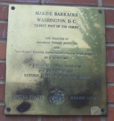
On 7th Street Southeast just south of Virginia Avenue Southeast, on the right when traveling south.
The oldest active post in the Marine Corps, Marine Barracks Washington, D.C., was founded in 1801 by President Thomas Jefferson and the second commandant of the Marine Corps, Lt. Col. William Ward Burrows. Better known as "8th & I," the Barracks . . . — — Map (db m210266) HM
On Ely Place Southeast 0.1 miles west of 37th Street Southeast, on the right when traveling west.
A key event in the landmark 1954 school desegregation case Brown v. Board of Education occurred here at Sousa Junior High (now Middle) School. In 1950 Sousa was one of several new DC schools for white children. When Spottswood T. Bolling, . . . — — Map (db m187431) HM
On Dahlgren Avenue Southeast at Warrington Avenue Southeast, on the right when traveling north on Dahlgren Avenue Southeast.
Authorized by the first Secretary of the Navy, Benjamin Stoddard, is the U.S. Navy's oldest shore establishment. It occupies land set aside by George Washington for use by the federal government. The Navy Yard expanded rapidly as a shipbuilding . . . — — Map (db m90434) HM
On Martin Luther King Jr. Avenue Southeast south of Pomeroy Road Southeast, on the left when traveling north.
St. Elizabeths
Hospital
has been designated a National Historic Landmark This site possesses national significance in commemorating the history of the United States of America. — — Map (db m58305) HM
On Jefferson Drive Southwest east of 12th Street Southwest, on the right when traveling east. Reported permanently removed.
The Arts and Industries Building, the second oldest Smithsonian building, was the first building designed for the National Museum, as the Smithsonian's first museum was known. It was constructed between 1879 and 1881 to meet the need for more . . . — — Map (db m108904) HM
On Jefferson Drive Southwest east of 12th Street Southwest, on the right when traveling east.
Erected 1847-57. Designed by James Renwick, Jr. in twelfth century Romanesque style for the first offices, research laboratories, exhibits, collections, and lectures of the Smithsonian Institution. Dedicated to the increase and diffusion of . . . — — Map (db m46413) HM
Near County Road 325 north of Southeast 190th Place, on the left when traveling north.
Marjorie Kinnan Rawlings House and Farmyard has been designated a National Historic Landmark This site possesses national significance in commemorating the history of the United States of America 2006 National Park Service . . . — — Map (db m185040) HM
Near Museum Circle 0.2 miles south of Lighthouse Road, on the left when traveling south.
Established by the United States Air Force in 1950 as the Joint Long Range Proving Ground, this area supported the initial development of America’s space program. The era of the Space Age for the U.S. began on this site with the launch of . . . — — Map (db m154077) HM
On Windover Way at Windover Trail on Windover Way.
Discovered by accident in 1982, the Windover site is a burial place of Early Native Americans who inhabited this region 7,000 to 8,000 years ago. The burials were placed underwater in the peat of the shallow pond. This peat helped to preserve . . . — — Map (db m60342) HM
Norman Film Studios has been designated a National Historic Landmark.
This site possesses national significance for its association
with the production of moving picture films beginning in 1916
with the Eagle Film City. In 1921, Richard . . . — — Map (db m252518) HM
On Arlington Road at Westdale Drive, on the right when traveling west on Arlington Road.
While Jacksonville bustled with the activity of motion picture filming during the years 1908 through 1916, by the early 1920s little of the industry remained in town. However, over on Laura Street in the Springfield section of Jacksonville, brothers . . . — — Map (db m93419) HM
On Southern Teminus of S Hogan Street, in the median.
Approximately 15 miles up river from this point, the Union transport Maple Leaf was destroyed by a Confederate mine during the early morning hours of April 1, 1864. The Maple Leaf sank to the bottom of the St. Johns River after . . . — — Map (db m58347) HM
On June 14, 1898, Lt. Col. Theodore Roosevelt
and the First United States Volunteer Cavalry,
known as the Rough Riders, embarked from Port
Tampa for victory in the Spanish-American War.
The Tampa Bay Hotel was used as headquarters
for . . . — — Map (db m20160) HM
On West Kennedy Boulevard near University Drive, on the right when traveling west.
Henry B. Plant built this ornate Moorish structure at a cost of $3 million. Opened in 1891, it became the social and cultural center of early Tampa. During the Spanish American War it was headquarters for troops going to Cuba and housed such . . . — — Map (db m20020) HM
This former grand old resort hotel, a seat of
culture and education, has been the proud
symbol of Tampa since 1891. Erected by The
University of Tampa Class of 1991, on the
occasion of the centennial of the building,
this marker is a . . . — — Map (db m20063) HM
On East 7th Avenue/Broadway Avenue (State Road 45/574) at North16th Street on East 7th Avenue/Broadway Avenue.
Chartered on September 7, 1891, El Centro Español was the first Latin club organized in Ybor City. As a mutual aid society, it provided early Spanish immigrants with a framework by which they maintained their identity and culture while . . . — — Map (db m31711) HM
On East 7th Avenue (a.k.a. La Séptima) just east of Nuccio Parkway.
Vincente Martinez-Ybor, a wealthy Spanish
cigar manufacturer from New York and
Key West, began development of Ybor City
in 1885. On April 12,1886, 500 Cuban cigarmakers
boarded the sidewheeler Hutchinson in
Key West and sailed for Tampa. . . . — — Map (db m31712) HM
Mission San Luis de Talimali was among the largest and most important missions in Spanish Florida. Its parishioners were Apalachee Indians who were descendents of those people whose village Hernando de Soto appropriated during the winter of . . . — — Map (db m79564) HM
Near East Fort King Street at SE 39th Avenue, on the left when traveling east.
Fort King was a typical U.S. Army frontier fort and a noteworthy symbol of the longest and costliest war America had with its native people - the Seminole War. Fort King is a narrative that speaks of a complicated history as relates to the . . . — — Map (db m201351) HM
On North Krome Avenue (State Road 997) north of East Mowry Drive, on the right when traveling north.
Historic Town Hall has been designated a National Historic Landmark.
This building was designed by Miami architect H. Hastings Mundy and built in 1917. As the Homestead Town Hall, it housed the City Fire Department, the Police Station and the . . . — — Map (db m73367) HM
Near Brickell Avenue (U.S. 1/41) north of Southeast 5th Street, on the right when traveling north.
The Miami Circle site would not exist today if it were not for the support of the community. Public outcry over the impending destruction of the Miami Circle led to additional archaeological research and preservation of the 2.2 acre parcel of . . . — — Map (db m65471) HM
Near Brickell Avenue (U.S. 1/41) north of Southeast 5th Street, on the right when traveling north. Reported unreadable.
On this spot of land at the mouth of the Miami River, a historic discovery shed new light on one of Florida's early peoples - the Tequesta. During the demolition of the Brickell Point apartments in 1998, archaeologists uncovered preshistoric . . . — — Map (db m292489) HM
Near Brickell Avenue (U.S. 1/41) north of Southeast 5th Street, on the right when traveling north.
The Miami Circle at Brickell Point has been designated a National Historic Landmark This site possesses national significance in commemorating the history of the United States of America. The Miami Circle is a 38-foot diameter ring of post . . . — — Map (db m65646) HM
Near SW 124th Avenue 1 mile south of SW 152nd Street, on the right when traveling south.
U.S. Car No. 1,
Ferdinand Magellan
has been designated
National
Historic Landmark
Presidential railroad car built for the
exclusive use of the President of the
United States of America
1942
Restored and exhibited by
The . . . — — Map (db m73445) HM
Near Quay Road at Butler Boulevard, on the right when traveling south.
This 327 foot long, 6,200 hp cutter with a crew of 300 served in World War II, Vietnam, and the Korean war. The Ingham received a record 35 awards and was the most decorated vessel of its time. During it's service December 15, 1942, the Ingham . . . — — Map (db m222494) HM WM
Near Miracle Strip Parkway SE at Eglin Parkway SE.
Preserving the Mound
Florida is home to a rich variety of cultural resources that represent our society. Many significant archaeological sites, like the Fort Walton Temple Mound, are in public ownership.
The preservation of the temple . . . — — Map (db m281465) HM
Whitehall
(Henry Morrison Flagler Museum)
has been designated a
National Historic Landmark
This site possesses national significance in commemorating the history of the United States of America
2000
National Park Service . . . — — Map (db m292673) HM
On Johnson Avenue at McDonald Street, on the right when traveling north on Johnson Avenue.
At Florida Southern College is located the largest collection of buildings on one site ever created by Frank Lloyd Wright, one of America's foremost architects. Wright's plan for the campus is the only tangible example of his community planning . . . — — Map (db m13632) HM
On Fort Mose Trail east of N. Ponce de Leon Blvd. (U.S. 1).
On the shore of Robinson Creek, ¼ mile east of this marker, was the site of a Spanish mission for Indians left homeless during Queen Anne's War. Since 1688, Negro slaves from the English colonies had found refuge in Spanish St. Augustine. On . . . — — Map (db m126969) HM WM
On King Street (State Road 214) at Granada Street on King Street.
The magnificent structure was erected between 1885 and 1887 by Henry M. Flagler, the hotel and railroad magnate whose activities contributed greatly to the development of Florida's eastern coastal area. Designed by the New York architectural firm . . . — — Map (db m5994) HM
Near Battlefield Parkway (County Road 603) 0.2 miles south of County Road 605.
Major Francis L. Dade and his command consisting of detachments of the Fourth Infantry, Second and Third Artillery United States Army, while marching from Tampa Bay to Fort King was attacked by a superior force of Seminole Indians commanded by Mico . . . — — Map (db m20024) HM
Near Doctor Mary McLeod Bethune Boulevard just west of Doctor MLK Jr. Boulevard, on the right when traveling west.
Mary McLeod Bethune Home
has been designated a
National
Historic Landmark
This site possesses national significance in commemorating the history of the United States of America
1975
National Park Service
United . . . — — Map (db m192160) HM
On South Peninsula Drive south of Ocean Way Drive, on the left when traveling south.
Ponce de Leon Inlet Lighthouse Has Been Designated A National Historic Landmark This site possesses national significance in commemorating the history of the United States of America 1998 National Park Service United States Department of . . . — — Map (db m34434) HM
Near Old Fort Road 0.2 miles south of Yacht Lane, on the right when traveling south.
Fort San Marcos de Apalache has been designated a Registered National Historic Landmark Under the provisions of the Historic Sites Act of August 21, 1935 this site possesses exceptional value in commemorating or illustrating the history of . . . — — Map (db m186477) HM
On Indian Mound Road 0.8 miles east of Douthit Ferry Road, on the left when traveling south.
For over 100 years Etowah Indian Mounds were the Tumlin Mounds. In 1832 Col. Lewis Tumlin came to Cass County (Bartow) and drew the land lot that contained the mounds. Col. Tumlin served as county sheriff from 1834 to 1840. As young soldiers, Gen. . . . — — Map (db m13471) HM
Near Fort Jackson Road (Woodcock Street) 1.3 miles north of East President Street.
Fort James Jackson has been designated a National Historic Landmark This site possesses national significance in commemorating the history of the United States of America 2000 National Park Service United States Department of the . . . — — Map (db m190846) HM
Starting in the Summer of 1812, Fort
Jackson was garrisoned by various
units of the United States Army and
Georgia Militia. These troops included
the 8th U.S. Infantry, 4th U.S. Artillery,
and the Chatham Artillery. — — Map (db m24999) HM
On Bull Street at Oglethorpe Avenue, on the right when traveling north on Bull Street.
Birthplace of
Juliette Gordon Low
Founder of Girl Scouts
In The United States
Owned and Operated
By The
Girl Scouts Of The U.S.A.
(Bottom):
The Juliette Gordon Low
birthplace
Has Been Designated A
National . . . — — Map (db m5582) HM
On Abercorn Street, on the right when traveling north.
Owens-Thomas House has been designated a National Historic Landmark. This site possesses national significance in commemorating the history of the United States of America. — — Map (db m19632) HM
On Bull Street at Macon Street, on the right when traveling south on Bull Street.
General William Tecumseh Sherman used this house as headquarters from Dec. 22, 1864, until Feb. 1, 1865. Charles Green offered the use of his home to General Sherman and his staff. Sherman's chaplain conducted the Christmas services in St. John's . . . — — Map (db m8881) HM
On International Drive, Hutchinson Island near Savannah River.
The N.S. Savannah, the first nuclear-powered cargo/passenger ship, built by the New York Shipbuilding Corporation,
was launched on July 21, 1959 and commenced her maiden voyage at sea on Friday March 23, 1962. Before
embarking on a . . . — — Map (db m58595) HM
On West Bryan Street near Bull Street, on the left when traveling west.
Savannah Historic District
has been designated a
Registered National Historic Landmark
Under the provisions of the Historic Sites Act of August 21, 1935 this site possesses exceptional value in commemorating or illustrating the . . . — — Map (db m5537) HM
On Martin Luther King Jr. Blvd. (West Broad Street) near West Congress Street, on the left when traveling north.
Designed by noted English architect William Jay,
this house was built for William Scarbrough,
president of the Savannah Steamship Company.
Completed in 1819, it is an excellent example of
the neoclassical style. Scarbrough hosted
President . . . — — Map (db m35303) HM
On Riverside Parkway at Riverside Industrial Park, NE, on the left when traveling north on Riverside Parkway.
At this house’s core is the 1790s log home of Major Ridge (c.1771-1839), a leader in the Cherokee Nation. His 223-acre plantation supported numerous outbuildings, orchards and slaves while the family served as ferryboat operators and merchants. It . . . — — Map (db m14981) HM
On Edgewood Avenue SE at Courtland Street SE, on the right when traveling east on Edgewood Avenue SE.
This building has been designated as a National Historic Landmark. Best known to Atlantans as the first Georgia bottling plant of the Coca-Cola Company, this small 2-story commercial building, which was constructed in 1890, originally housed both . . . — — Map (db m186413) HM
On Auburn Avenue at Jackson Street, on the right when traveling east on Auburn Avenue.
has been designated a
National Historic Landmark This site possesses national significance in commemorating the history of the United States of America May 5th 1977 National Park Service United States Department of the Interior
[bottom . . . — — Map (db m6675) HM
On Auburn Avenue NE east of Jackson Street NE, on the right when traveling west.
The world of young Martin Luther King, Jr., revolved around Ebenezer Baptist Church. Here his grandfather and father preached in favor of desegregation, voting rights, and equal pay—social issues he would later embrace and espouse. His . . . — — Map (db m127272) HM
On Old Plantation Road north of Schoolhouse Lane, on the right when traveling north.
Chartered by the State of Georgia to be trustworthy stewards of the island, the Jekyll Island Authority has been very active in the preservation of the National Historic Landmark District. The rehabilitation of Crane Cottage and Cherokee in . . . — — Map (db m115119) HM
On Pier Road at Riverview Drive, on the right when traveling west on Pier Road.
The Executive Committee hired architect Charles Alexander to design the Clubhouse. He designed the building in a Queen Anne style that complemented the natural beauty of the island and emphasized the rustic simplicity that the Jekyll Island Club . . . — — Map (db m115117) HM
First built 1816 rebuilt on
this site 1826 Home of famous
author Stephen Vincent Benet
whose father
Colonel James Walker Benet
commanded Augusta Arsenal 1911 to 1919 — — Map (db m46873) HM
On Riverdale Road 0.4 miles north of U.S. 123, on the right when traveling north.
Traveler’s Rest
has been designated a
Registered National
Historic Landmark
Under the provisions of the
Historic Sites Act of August 21, 1935
This site possesses exceptional value
commemorating and illustrating
the history . . . — — Map (db m60741) HM
Liberty Hall
Has been designated a
National historic Landmark
This site possesses National significance in commemorating the history of the United States of America
1983
National Park Service
United States Department of the Interior — — Map (db m46025) HM
On East Robert Toombs Avenue (Business U.S. 78) at Poplar Drive (Georgia Route 17), on the right when traveling east on East Robert Toombs Avenue.
This was the home of Robert Toombs -- planter, lawyer, and distinguished Southern statesman. Born July 2, 1810, Robert Toombs was educated at Franklin College, Georgia, at Union College, New York, and at the University of Virginia. He was a member . . . — — Map (db m25582) HM
On Kealakehe Parkway, on the right when traveling west.
Honokohau Settlement has been designated a Registered National Historic Landmark under the provisions of the Historic Sites Act of August 21, 1935. This site possesses exceptional value in commemorating and illustrating the history of the United . . . — — Map (db m4248) HM
Near Palani Road near Kaahumanu Place, on the left when traveling north.
Home of Kamehameha I, founder of the Hawaiian Kingdom, from 1812 until his death. Here he built his residence, storehouses and fishponds and remodeled 'Ahu'ena Heiau, a temple of great antiquity. When he died here May 8 1819, his son Liholiho was . . . — — Map (db m110592) HM
On South Point Road 11 miles south of Mamalahoa Highway (Hawaii Route 11), on the left when traveling south.
South Point Complex has been designated a Registered National Historic Landmark under the provisions of the Historical Sites act of August 21st 1935. This site possesses exceptional value in commemorating and illustrating the history of United . . . — — Map (db m2314) HM
On South King Street, on the right when traveling south.
'Iolani Palace is a living restoration of the offical royal residence for the Kalakaua Dynasty that ruled the Kingdom of Hawai'i from 1874 to 1893. King Kalakaua, who resigned for 17 years, built the palace in 1882 as a symbol of Hawaii's civilized . . . — — Map (db m74148) HM
On Punchbowl Street, on the left when traveling east.
Built of gaint coral slabs, hewn from ocean reefs, this sanctuary became known as The Stone Church. This structure was preceded by a succession of four thatched grass buildings which served as houses of worship until ground was broken in 1837. . . . — — Map (db m74145) HM
U.S. Naval Base, Pearl Harbor
has been designated a
Registered National
Historic Landmark
Under the provisions of the
Historic Sites Act of August 21, 1935
this site possesses exceptional value
in commemorating and . . . — — Map (db m4526) HM
Near Kuilima Drive 0.5 miles north of Hawaii Route 83, on the left when traveling north.
Mobile Radar Unit SR-270B
has been designed a
National Historic Landmark.
This site possesses national significance
in commemorating the history of the
United States of America. — — Map (db m154432) HM
Has Been Designated a
Registered National Historic Landmark
Under the Provisions of the
Historic Sites Act of August 21, 1935
This Site Possesses Exceptional Value
In Commemorating and Illustrating
the History of the United States . . . — — Map (db m305301) HM
On State Highway 27 at milepost 1, 0.2 miles north of 1800 South Road, on the right when traveling south.
A vast display of towering granite rocks (16 miles southeast of here) attracted emigrants who were on their way to California.
A gold rush visitor, July 14, 1849, reported that "you can imagine among these massive piles, church domes, . . . — — Map (db m31637) HM
On U.S. 91 just south of Hot Spring Road, on the right when traveling north.
Very few Northwestern Shoshoni survived a battle here that turned into a massacre by Col. P.E. Connor’s California Volunteers.
In 1863, Conner and his force set out from Salt Lake City on a cold January campaign in response to friction . . . — — Map (db m165800) HM
Near South Mission Road at Dredge Road, on the left when traveling west.
Built by the Coeur d’Alene Tribe in cooperation with members of the Society of Jesus – restored with dedication as a 1976 bicentennial project by Henry Lawrence Day and his friend and helper Al Almquist in whose honor this memorial is . . . — — Map (db m110800) HM
On East Peru Street 0.1 miles east of South Bureau Valley Parkway/County Road 2100 E, on the left when traveling east.
This house was one of the most important stations in the Underground Railroad movement in Illinois. Runaway slaves were harbored by the Lovejoy family until arrangements could be made for them to travel to the next station on their way to Canada. — — Map (db m259404) HM
On East Peru Street (U.S. 6) just west of 8th Street, on the right when traveling west.
This two-story frame structure was the home of abolitionist Owen Lovejoy, who was born in Maine in 1811. Lovejoy moved into the house in 1838, when he became a Congregationalist minister. He was leader in the formation of the Republican Party in . . . — — Map (db m310285) HM
On West Gregory Drive 0.2 miles east of South 6th Street, on the left when traveling east.
Started in 1876, the Morrow Plots are the oldest field experiment in the United States. First known as “Rotation Experiment No. 23” and modeled after trials at Rothamsted, England, the plots were established to study the long-term effects of crop . . . — — Map (db m225531) HM
On Central Avenue at Gladys Avenue, on the right when traveling south on Central Avenue.
Columbus Park
has been designated a
National Historic Landmark
This park is a premier example of the Prairie Style of landscape architecture. It is considered the masterpiece of landscape architect and conservationist Jens Jensen. . . . — — Map (db m260360) HM
On West Exchange Avenue east of South Peoria Street, on the left when traveling east.
The Union Stock Yard and Transit Company, Chicago's legendary livestock market and slaughterhouse, opened at this site on Christmas Day, 1865. Here, 320 acres of swampland lying between Pershing Avenue, Halsted Street, 47th Street, and Ashland . . . — — Map (db m244189) HM
On West Exchange Avenue east of Peoria Street, on the left when traveling west.
At one time sprawling over 475 acres, the Union Stock Yard thrived for more than a century, then closed entirely. This rugged gate, erected in 1875, survives as one of the few visual reminders of Chicago's past supremacy in the livestock and . . . — — Map (db m244150) HM
Near South State Street 0.1 miles north of 35th Street, on the right when traveling south.
S.R. Crown Hall has been designated a National Historic Landmark
Crown Hall was designed by Ludwig Mies van der Rohe and finished in 1956, the most monumental of Mies' buildings at the Illinois Institute of Technology. In continuous use . . . — — Map (db m270265) HM
On North Astor Street at East Schiller Street, on the right when traveling north on North Astor Street.
has been designated a
National Historic Landmark
This home, designed in 1891 by Louis Sullivan and
Frank Lloyd Wright, is an important work in the
development of modern residential architecture
and possesses national significance . . . — — Map (db m188276) HM
On North Clark Street at West Addison Street, on the right when traveling north on North Clark Street.
Wrigley Field
has been designated a
National Historic Landmark
Opened April 23, 1914, this ballpark has been home to the Chicago
Cubs since 1916 and was the home of the Chicago Bears from 1921 to
1970. It played an important role . . . — — Map (db m192529) HM
On West Fullerton Parkway at North Cannon Drive, on the right when traveling east on West Fullerton Parkway.
Alfred Caldwell Lily Pool
has been designated a
National Historic Landmark
This site is a premier example of the Prairie style of landscape architecture. Alfred Caldwell, a landscape designer, architect, teacher and poet, . . . — — Map (db m47846) HM
On South Halsted Street, on the right when traveling south.
Jane Addams' Hull House
has been designated a
Registered National
Historic Landmark
under the provisions of the Historic Sites Act of August 21, 1935. This site possesses exceptional value in commemorating or illustrating the history . . . — — Map (db m99710) HM
Henry Gerber House has been designated a National Historic Landmark
Henry Gerber founded and operated the Society for Human Rights out of his home at this location in 1924-25. The society was the first chartered organization advocating for the . . . — — Map (db m261159) HM
On East 18th Street east of South Indiana Avenue, on the right when traveling east.
Clarke House
The Henry B. Clarke family built their house in the Greek Revival style in 1836 near what is now 1625 S. Michigan Avenue. In 1872 the house was sold and moved to 4526 S. Wabash. It was relocated to its present site in 1977 and . . . — — Map (db m308687) HM
On South Prairie Avenue at East 18th Street on South Prairie Avenue.
A mature Richardson design, Glessner House is famous for its site development, innovative floor plan and rugged Romanesque facade. Glessner House, a reminder of the fabulous Prairie Avenue era, is the only remaining Chicago building by this renowned . . . — — Map (db m308616) HM
On South Michigan Avenue at East Cullerton Street, on the right when traveling south on South Michigan Avenue.
When this neo-Gothic church was designed by a prominent New York architect, the surrounding streets, including Prairie Avenue one block east, were lined with the homes of wealthy Chicagoans. The fine interior decorations recall the congregation that . . . — — Map (db m121834) HM
On Michigan Avenue north of Cullerton Avenue, on the right when traveling south.
Second Presbyterian Church of Chicago has been designated a National Historic Landmark
This church possesses national significance as one of the earliest, most complete and intact expressions of ecclesiastical Anglo-American arts and crafts. . . . — — Map (db m267401) HM
On South Michigan Avenue at East Congress Parkway, on the right when traveling south on South Michigan Avenue.
The extraordinary engineering talent of Dankmar Adler and the architectural genius of Louis Sullivan created this building to reflect the cultural maturity of Chicago. Combining hotel and office space with a splendid theater, the Auditorium was a . . . — — Map (db m34975) HM
In this building, an appropriate exterior expression for the new skeleton-framed skyscraper was found. The facade clearly reveals its underlying structure with broad windows set in a framework of narrow piers and spandrels. In its open and . . . — — Map (db m262737) HM
On Chicago Avenue north of Church Street, on the right when traveling south.
[Front side of marker:]
Frances E. Willard (1839-1898)
Frances Willard, a long-time resident of Evanston, was one of the most prominent social reformers of the 19th century and a generating influence in America's long history of social . . . — — Map (db m268031) HM
The residence of Charles Gates Dawes
1865 - 1951
Soldier · Statesman · Diplomat · Banker
Vice President of the United States
Given by him to Northwestern University
with the hope that it might become the
home of the Evanston Historical . . . — — Map (db m139208) HM
Has been designated a
National Historic Landmark
This monument represents the labor movements
struggle for workers rights and possesses National
significance in commemoration the history of
The United States of America
1997 . . . — — Map (db m115585) HM
Near Des Plaines Avenue 0.4 miles south of Eisenhower Expressway (Interstate 290), on the right when traveling south.
1887
The day will come when our silence will be more powerful than the voices you are throttling today.
[Plaque on the rear:]
These charges are of a personal character, and while they seem to be sustained by the record of the trial and the . . . — — Map (db m267562) HM
On Chicago Avenue at Forest Avenue, on the right when traveling east on Chicago Avenue.
Frank Lloyd Wright Home and Studio
1889-1909
Frank Lloyd Wright, Architect
Frank Lloyd Wright's Oak Park Home and Studio
was his residence, studio and architectural
laboratory from 1889 to 1909. In this studio,
the architect . . . — — Map (db m188815) HM
On Kenilworth Avenue just south of Lake Street, on the right when traveling north.
In 1905, the Unity Church of Oak Park, home to a Universalist congregation, was struck by lightning and burned to the ground. The congregation commissioned Frank Lloyd Wright to design a new building for them.
Wright's bold design with its . . . — — Map (db m227636) HM
On Scottswood Road at Coonley Road, on the left when traveling east on Scottswood Road.
Avery Coonley House has been designated a Registered National Historic Landmark
Under the provisions of the Historic Sites Act of August 21, 1935 this site possesses exceptional value in commemorating or illustrating the history of the . . . — — Map (db m242943) HM
1456 entries matched your criteria. Entries 301 through 400 are listed above. ⊲ Previous 100 — Next 100 ⊳