225 entries match your criteria. Entries 101 through 200 are listed.⊲ Previous 100 — The final 25 ⊳
The Spirit of ’76, America’s Bicentennial Celebration Historical Markers
During the time America was celebrating its Bicentennial (1776-1976), historic markers were erected to commemorate different events or projects. This Marker Series is for those historic markers that have the Bicentennial logo, were inspired by, have reference to it in someway within its context or was placed by a Bicentennial committee, commission etc.
On U.S. 190, 0.6 miles north of Hauser Road, on the right when traveling north. Reported missing.
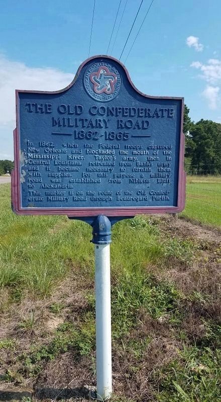
In 1862, when Federal troops captured New Orleans and blockaded the mouth of the Mississippi River, Taylor's army, then in Central Louisiana, retreated from Bank's army and it became necessary to furnish them with supplies. For this purpose a . . . — — Map (db m176941) HM
Near Tower Drive south of Dalrymple Drive, on the right when traveling south.
"Erected as an enduring monument to memorialize Louisiana's sons and daughters who died in World War I. The memorial was funded and dedicated April 30, 1926 by General John R. McQuigg, National Commander of the American Legion" — — Map (db m89333) WM
On State Highway 151 at State Highway 152, on the right when traveling west on State Highway 151.
Autrey House - Built 1849 - Oldest restored dogtrot log house in Lincoln Parish. Built on 200 acres by Absalom Autrey and his wife Elizabeth Norris Autrey after they moved from Selma, Alabama in 1848. Listed on the National Register of Historic . . . — — Map (db m237488) HM
On North Trenton Street (U.S. 63/167) south of Toma Lodge Drive, on the left when traveling north.
Chosen in 1889 as site for the Louisiana Chautauqua Society's Summer Program of education for teachers and culture for all. It flourished from 1891 to 1905. Many famous speakers lectured here. Forerunner of Louisiana Tech University. — — Map (db m221102) HM
On U.S. 167 at State Route 3072, on the right when traveling north on U.S. 167.
First road across north Louisiana wilderness. Began as Indian trail. Served as Monroe - Shreveport stage coach road as well as a pioneer route to Texas. After 1847 known as Wire Road because of parallel telegraph line. — — Map (db m138772) HM
On Decatur Street east of St. Peter Street, on the right when traveling east.
[Panel 1]:
On and near this site since 1718 has centered the military activities of both regular and citizen soldiers of France, Spain, the Confederacy and the United States. On either side were the redoubts forming the “Great . . . — — Map (db m24684) HM
On Hamberlin Street south of North Main Street (Louisiana Highway 10), on the left when traveling south.
Erected to the memory of those Revolutionary War Patriots who not only helped to win freedom for our Country but also helped to carve a civilization within St. Helena Parish. — — Map (db m88218) WM
On State Highway 16 at Eli Lane, on the left when traveling east on State Highway 16.
Parish seat from 1812-1832. Land office - a clearinghouse for public lands between the Mississippi and the Pearl Rivers 1812-1837. Montpelier Academy 1833-1840. Early post office St. Helena 1814-1859. Connected to Natchez Trace. — — Map (db m94882) HM
On Myrtle St., 0.3 miles north of Auditorium Dr., on the right when traveling south.
The Militia of the Attakapa Region of South Central Louisiana served under Spain’s Governor of the colony, Bernardo de Galvez in his campaigns against the British during the War for American Independence. — — Map (db m85733) HM
On Myrtle Drive north of Auditorium Drive, on the right when traveling south.
Famed as surgeon in KY. 1806. Settled Attakapas, LA. 1809. Became large landowner, sugar planter in St. Mary, serving many years in LA. Legislature. Town of Brashear, now Morgan City, incorporated 1860. — — Map (db m85751) HM
On North 5th Street (U.S. 171) at Ian's End, on the right when traveling north on North 5th Street.
Only soldier from Louisiana to serve under General John J. Pershing's "One Hundred Heroes" in World War I, Company B, 28th Infantry. Received Distinguished Service Cross and the Distinguished Service Medal. — — Map (db m86665) HM
On Main Street at the Pleasant River, on the left when traveling east on Main Street.
Early Settlers of the Pleasant River Known to Have Been in Action Against the British During the Revolution of 1775 to 1783
[Honor Roll of Veterans] — — Map (db m55088) HM WM
On Fort Road (County Highway 5) 0.3 miles east of 521st Avenue (County Highway 10), on the right when traveling east.
On the Red River Oxcart Trail to Traverse des Sioux
1854–First white man to claim land–Bruce Pierce.
1855-56–Then; Christian, John & Andrew Anderson; Christian & Torger Peterson & the Jensens.
1862–The Applebaum home . . . — — Map (db m73506) HM
On Main Street (U.S. 14) at 4th Street (County Highway 24), on the left when traveling west on Main Street.
1855 - First settlers were Jacob Harmon, Mr. Haresine, John Sidel, Jacob Gfeller, & Ole Nelson - Most of the early settlers came from Germany.
1856 - Village of Red Stone, near the ferry, was surveyed but never developed.
1856 - Hilo post . . . — — Map (db m66070) HM
Near County Road 30, 0.7 miles west of State Route 4, on the right when traveling west.
1826 Licensed U.S. fur buyer with H. H. Sibley.
1834 Owned Little Rock Trading Post on the Minnesota River.
1837 Interpreter for Indian Treaty at Fort Snelling and Washington D.C.
1838-39 Guide for Jean N. Nicollet, U.S. Gov’t . . . — — Map (db m183868) HM
On 515th Avenue (County Highway 10) 0.7 miles north of 350th Street (County Highway 1), on the right when traveling north.
Creamery, organized as "Riverside" in 1895 - changed to "Bernadotte" in 1944 - New creamery built 1936 - cost $10,518. It handled whole milk at all times. Patorns delivered cream over 40 years. Co-Op dissolved in 1959. Building sold and used as . . . — — Map (db m73900) HM
On 515th Avenue (County Highway 10) 0.9 miles north of 350th Street (County Highway 1), on the left when traveling north.
Organized 4 May 1866 at Magnus Peterson home, Pastor John Pehrson, by Swedish settlers, 21 charter families, 104 families by 1870. Commemorated on native stone, set in 1937.
First worship in homes, in school-house No. 26; first church built . . . — — Map (db m79770) HM
On Main Avenue east of 7th Street, on the left when traveling west.
First settler in township was Louis Sharro. John Bush and family came in 1854 and kept an Inn for travelers. Township organized in 1858. First post office 1859 - moved to Village 1897. Village platted 1896; Incorporated Feb., 1900. Minneapolis & St. . . . — — Map (db m66615) HM
On State Highway 111, 0.4 miles south of 370th Street (State Highway 22), on the right when traveling north.
New Sweden Creamery Association was organized Jan. - 1895. 350 cows were pledged for the Creamery.
The creamery was built in 1896.
Jan., 1898, Samuel Haugdahl was hired as butter maker. He received many state and national awards in . . . — — Map (db m73922) HM
On State Highway 22 at milepost 76,, 0.2 miles east of County Road 52, on the left when traveling east.
The name Norseland was originated by community spirited settlers -
1858-Norseland Store was built by John Burke
1896-Patrons built Norseland Co-op Creamery next to the Burke store which had a post office
1922-Emil Swenson became a partner . . . — — Map (db m73868) HM
On State Highway 22, 0.4 miles east of County Road 52, on the right when traveling east.
1854-Methodist church organized-disbanded 1900.
1858-Norwegian Lutheran church organized - 1911 present church erected.
1858-Scandian Grove Lutheran church organized. 1888 stone church erected.
1858-Burkes had a general store & post . . . — — Map (db m73881) HM
On County Road 20, 1.2 miles north of State Highway 22, on the right when traveling north.
March, 1856 – Traverse des Sioux and St. Peter organized a cemetery Assoc. purchasing 10 acres. Early Missionaries, pioneer, and Civil War Veterans are buried here.
Rev. T. C. Williamson, first Missionary in this area and Rev. Stephen . . . — — Map (db m66414) HM
On Broadway Avenue (State Highway 99) east of Front Street (State Highway 22), on the right when traveling east.
About 150 feet North of this Park was the old boat landing.
Boat transportation from the earliest years of this area until the 1870's was the main source of commercial transportation.
The first steamboat to come up the Minnesota River was . . . — — Map (db m65784) HM
On North Minnesota Avenue (U.S. 169) at West Chestnut Street, on the right when traveling north on North Minnesota Avenue.
First property owner was Wm. B. Dodd. Fourth property owner, Adolph Bornemann, born in Traverse des Sioux 1862. His father, Bernhard, a journalist from Germany came to Traverse des Sioux in 1856; built a hotel & raised sheep. 1869, the Bornemanns . . . — — Map (db m68094) HM
On North Main Street (U.S. 63) just north of 3rd Street Northwest, on the left when traveling north.
Richard Warren Sears (1863-1914), cofounder of Sears Roebuck and Company, was born in Stewartville and lived in this house from 1863 to 1869. Richard Sears was the son of James Sears — a pioneer Stewartville blacksmith. In 1869 Sears began his . . . — — Map (db m235257) HM
On 3rd Street North (State Highway 95) at 4th Avenue North, on the left when traveling north on 3rd Street North.
1776 • 1976
In memory of the 200th
anniversary of the
American Revolution and
the freedoms for which
it was fought.
May they always be.
Sponsored by
Hesley Jensen Post 491
American Legion and friends
Beneath this . . . — — Map (db m44162) HM
On East Lampkin Street east of South Washington Street, on the right when traveling east.
Organized July 28, 1839. Thirteen original members, one a slave. Used as a Confederate hospital during War Between the States. L. S. Foster, founder of Mississippi Baptist Orphanage, ordained here. General Stephen D. Lee, first president of A. & M. . . . — — Map (db m140704) HM
On Main Street (Missouri Route 82) 0.3 miles north of U.S. 54, on the left when traveling north.
This wagon represented the State of Missouri in the 1976 Bicentennial Wagon Train Pilgrimage to Valley Forge, Pennsylvania
Wagon Master, Raymond Williams
Asst. Wagon Master, Jack Nolan
Outriders, Georgia Williams
Dixie Nolan-Peak and . . . — — Map (db m57421) HM
On Court Square (Washington Avenue) at West Main Street, on the left when traveling south on Court Square (Washington Avenue).
Beneath this marker is a Time Capsule buried December 17, 1976, at 2:00 P.M. by the West Plains Bicentennial 1976 Steering Committee to be disinterred July 4th, 2076 by the Howell County Court Time capsule donated by . . . — — Map (db m186135) HM
On South Pleasant Street, 0 miles north of West Kansas Avenue, on the right when traveling north.
Alexander Campbell and Barton Stone, Disciple movement founders, preached to this congregation, founded July 4, 1835 with 35 members, 8 of whom were black. Alexander Procter was minister over 40 years. This neo-Roman church was designed by J.H. Felt . . . — — Map (db m140208) HM
On Pleasant Street near Lexington Avenue, on the left when traveling north.
The congregation dates from 1826. The church neither divided nor closed in the Civil War. Designed in 1888 by Nier, Hogg and Byram of Kansas City, Mo. Harry S. Truman first met Bess Wallace here in Sunday School in 1892. — — Map (db m121823) HM
On Maple Avenue near North Spring Street, on the left when traveling east.
The earliest Society of Methodists in the county was founded in Independence in 1835 with 10 charter members. Methodists have worshipped on this corner since 1840. The present Gothic style church, completed in 1859, was refaced and added to in 1929 . . . — — Map (db m34749) HM
On West Maple Avenue near Liberty Street, on the right when traveling east.
This 1933 courthouse, inspired by Independence Hall, contains restored courtroom and office of former Presiding Judge Harry S. Truman. Often remodeled, this building rests upon a foundation laid in 1828. Listed on the National Register of Historic . . . — — Map (db m34782) HM
On South Main Street at West Linden Avenue, on the right when traveling north on South Main Street.
The Misses Mollie and Josie Hughes hired the architectural firm of Gibbs and Parker, Kansas City, MO., to design this ornate Queen Anne style residence. Erected in 1887, it was one of a group of mansions on Main Street owned by the Bryant-Hughes . . . — — Map (db m140405) HM
On Walnut Street at Lynn Street, on the right when traveling east on Walnut Street.
Martin Kritser, a grocer, bought this lot in 1847 and probably had the house built soon after. Patrick McCarty, one time saloon keeper on this square, bought it in 1849. This modest house is typical of the majority of houses built during the city's . . . — — Map (db m34843) HM
On West Farmer Avenue just west of North Spring Street, on the right when traveling west.
In 1856 this Greek Revival and Italianate style house was completed by William McCoy, a merchant and banker, on property once owned by Samuel C. Owens, a merchant and Santa Fe trader. McCoy served as the first Mayor of Independence, MO., in 1849. — — Map (db m144541) HM
On North Delaware Street just south of West Waldo Avenue, on the right when traveling south.
Erected in 1887 by Aaron Flint Sawyer, a partner in the Chrisman - Sawyer Banking Company, this Queen Anne style residence is the design of T.B. Smith, a talented Independence, Mo., architect and builder. — — Map (db m140794) HM
On East White Oak Street just east of North Lynn Street, on the right when traveling west.
Organized in 1861, the present building was erected in 1886. The congregation has been a spiritual, educational and cultural leader. The first black school was held here.
Western Baptist Seminary was organized in this church. — — Map (db m144550) HM
On South River Boulevard south of West Lexington Avenue, on the right when traveling south.
August 3, 1831, Joseph Smith, Jr., Prophet and Founder of the Church of Christ, with seven other Church leaders, dedicated this site for the Temple in the City of Zion, where this Church believes the Lord will come to His people in the Last Days. — — Map (db m156377) HM
On West Lexington, 0.1 miles west of North River Boulavard, on the right when traveling west.
The first branch of the reorganized Church of Jesus Christ of Latter Day Saints in Independence was organized in 1873. Joseph Smith III, on April 6, 1888, laid the cornerstone of this cut sandstone building, for years the pulpit of Presidents of the . . . — — Map (db m140454) HM
On West Waldo Avenue at North River Boulevard on West Waldo Avenue.
In 1895 John and Martha Truman bought this house, built about 1886. Harry S. Truman (1884 - 1972) spent his boyhood here. The family moved in 1902. Later additions have greatly altered the original appearance of the house. — — Map (db m117025) HM
On Delaware Street at Truman Road (Missouri Route 12), on the right when traveling north on Delaware Street.
Built about 1867 by George Porterfield Gates, a mill owner. President Harry S. Truman and his wife, Bess Wallace Truman, granddaughter of Gates, made this their home from the time of their marriage in 1919. The "Summer White House" from 1945 to . . . — — Map (db m34731) HM
On West Lexington Avenue just east of South Proctor Place, on the right when traveling west.
About 1866 this brick house, in the then popular Italianate style was built by Samuel Hughes Woodson, lawyer, United States Congressman, 1856-1861, Circuit Judge, land developer, and stage and mail route operator. — — Map (db m144554) HM
On U.S. 40 at East 36th Street, on the left when traveling east on U.S. 40. Reported permanently removed.
This imposing farm mansion was erected in 1855 for B.F. Thomson by his slaves. The Thomson family fled during the Civil War. In 1866 the farm was sold on the courthouse steps to Rev. J.D. Gossett. One of the finest Greek Revival mansions in Jackson . . . — — Map (db m233659) HM
On Main Avenue at 9th Street, on the right when traveling north on Main Avenue.
of the courageous men of America. It is the responsibility of every one of us to keep the great ideal for which they fought and died. We must keep the faith with these Honored Dead. It is to us, the Living, that the Torch of Liberty and Freedom and . . . — — Map (db m53204) HM
On U.S. 34 at South 6th Street, on the left when traveling east on U.S. 34.
Since 1868, Seward has, with but few interruptions, sponsored a yearly 4th of July celebration which has gained national attention. This square, the original site of the festival, is today its focal point. Special trains once brought revelers here . . . — — Map (db m101843) HM
On Interstate 80 at milepost 355.2, on the right when traveling west.
The American Bicentennial was a time for pondering the past and speculating about the future. Nebraskans commissioned a series of modernistic sculptures for Interstate highway rest areas that would dramatize this meeting of past and future.
More . . . — — Map (db m79829) HM
On Victorian Ave at Prater Way (Nevada Route 445), on the right when traveling east on Victorian Ave.
Railroad Park was officially dedicated on July 4, 1976, in commemoration of our nation's 200th birthday. It was officially named James C. Lillard Railroad Park, by the City of Sparks City Council on July 12, 1976, in honor of Mayor James C. . . . — — Map (db m67227) HM
On Broad Street at Bank Road, on the right when traveling north on Broad Street.
Near this site, one of our country’s first ferries was operated from circa 1695 to late 19th century. During Revolutionary times, it was used by Washington and his troops. This area was called “Dunks Ferry” before Beverly, N.J. was . . . — — Map (db m35872) HM
On Main Street, on the right when traveling south.
King George of England granted charter to Christ Church, Belleville on Feb. 10, 1746. First church built here 1836. Oldest grave marker date 1785. Church now at 393 Washington Ave. Original bell, 1837 and organ, 1875 there. Belleville Historical . . . — — Map (db m52167) HM
On Main Street at Belleville Tnpk (Rutgers St) (New Jersey Route 7), on the left when traveling south on Main Street.
First wooden bridge built in 1790 – Anthony Rutgers of the Rutgers family for which Rutgers University is named. Operated as a toll bridge until destroyed by a great flood 1841. His widow sold charter to widow of Nicholas Joralemon. New bridge . . . — — Map (db m52486) HM
In the Bicentennial Year the Swedish-American Community commemorates the founding of the First Swedish Church in New Jersey in 1703 on this site, visited April 8, 1976 by his Majesty Carl XVI Gustaf, King of Sweden. — — Map (db m79409) WM
On Main Street (New Jersey Route 670) near Veterans Drive.
The contents of this
Time Capsule
are presented
to the residents of Sayreville, New Jersey
in 2076 from the
residents of Sayreville, New Jersey
in 1976
Mayor John E Czernikowsky
Councilmen
Kenneth W. Buchanan, Sr. • Alvin W. . . . — — Map (db m5181) HM
On North State Road (New York State Route 34 at milepost 30.5), 0.2 miles south of Downs Road, on the left when traveling south.
William McCreedy and family, burial site. Soldier in Revolution. Born 1755 - Died 1824. Early Methodist meeting held in nearby family home. — — Map (db m88480) HM
On Wyncoop Creek Road (County Road 3) just south of Main Street (County Road 60), on the right when traveling south.
Generals John Sullivan and James Clinton were appointed by George Washington to lead a punitive expedition against the hostile tribes of the Iroquois Confederacy and to capture the British forts at Oswego and Niagara. The objectives were to . . . — — Map (db m198208) HM
On Warren Street at Park Place, on the right when traveling west on Warren Street.
was dedicated May 3, 1975 to honor the volunteers
and the nation. This fountain was made possible
through the generosity of the following:
[Concerned Citizens and Organizations] . . . — — Map (db m118546) HM
On U.S. 9 at Interstate 84, on the right when traveling north on U.S. 9.
[ American Revolution Bicentennial Memorial Marker : ] 1776 ★ ★ 1976 To all the brave souls who passed through, served, and died here at the site of the Northern Department Supply Depot, Fishkill, New York. 1776 – 1783 May . . . — — Map (db m190273) HM
On Franklin Avenue at Front Street, on the left when traveling east on Franklin Avenue.
1776 1976
Town of Washington
Village of Millbrook
Celebrate the Bicentennial
200 Years of Freedom
Erected by the Bicentennial Commission
Ernest A. Ciferri, Chairman
William L. Still, Co-Chairman
Robert J. Rogers, Co-Chairman . . . — — Map (db m139867) HM
On Broadway (U.S. 20) 0.2 miles south of West Main Street, on the right when traveling west.
Earliest big industry in Alden from the 1850's to the early 1900's. Local and foreign hides tanned for upper leather. Hemlock bark from nearby forests hauled in by horse and wagon, used in the process. The large building spanned Tannery Creek. — — Map (db m75544) HM
On Brant Farnham Road (New York State Route 249) at Brant Angola Road (County Route 323), on the right when traveling west on Brant Farnham Road.
Town of Brant Memorial Park Originally named Sampton in 1820, Morse's Corners in 1835, and organized as BRANDT on Mar. 25, 1839 after the Mohawk Chief Col. Joseph Brandt. His Indian name, Pha-wan-da-nee-gah, meant "Wood partly burned" or . . . — — Map (db m104240) HM
On Bidwell Parkway at Potomac Avenue, on the right when traveling north on Bidwell Parkway.
Founded 1851 as Buffalo Female Academy. First located on Johnson Park, the school moved to present site in 1909. The seminary remains the first and only non-sectarian private high school for girls in western New York. — — Map (db m80401) HM
On Main Street at South Division Street, on the right when traveling north on Main Street.
Ellicott Square Building Opened by Ellicott Square Company in 1896 as largest office building in world. Daniel H. Burnham, architect. Steel frame, brick and terra cotta exterior, Italian marble, ornamental iron decorations, and marble mosaic . . . — — Map (db m92875) HM
On Porter Avenue at Fargo Avenue, on the right when traveling west on Porter Avenue.
First women's college in western New York. Established 1908 by the Grey nuns. Center building, 1874, originally housed Holy Angels Academy. College led renewal of city's west side by expansion program, 1954-1969. — — Map (db m80027) HM
On Main Street (U.S. 20A) 0.2 miles west of Shearer Avenue.
in 1803 Joseph Ellicott with Jabez Warren, East Aurora's pioneer settler, surveyed and laid out Middle Road, also known as Big Tree Road, for the Holland Land Company. It extended a distance of 43 miles from the Genesee River to Lake Erie including . . . — — Map (db m74558) HM
On Ridge Road at South Park Avenue (U.S. 62), on the left when traveling east on Ridge Road.
Father Baker's Gas Well ——•—— At this site on August 22, 1891 natural gas was found at a depth of 1137 feet. This well and its twin continued to produce sufficient gas for many of the energy needs of Our Lady of Victory . . . — — Map (db m93920) HM
On East Quaker Road (U.S. 20A) at Baker Road, on the left when traveling east on East Quaker Road.
Built in 1840 - replaced log cabin erected when property was acquired from Holland Land Company in 1804. The Baker family - prominent Quakers in this area - lived here for five generations. This home served as one last station of Underground Railway . . . — — Map (db m80830) HM
On North Buffalo Road (New York State Route 240) at Webster Road, on the left when traveling north on North Buffalo Road.
The Webster Family were early settlers in this community. Erastus Webster served under Secretary of State Seward in the Cabinet of President Abraham Lincoln. He represented the U.S. Gov't during the transfer of the Confederate emissaries Mason and . . . — — Map (db m80546) HM
On Savage Road (County Route 225) 0.1 miles south of Genesee Road (County Route 409), on the right.
The present Sardinia Town Hall was the first Baptist Church in the area, built in 1829, dedicated in 1830. It was instrumental in later organization of churches in Arcade, Holland and Chaffee. — — Map (db m76271) HM
On Knoche Road, 0.1 miles east of Elmwood Avenue, on the right when traveling east.
Louis P.A. Eberhardt Home Kenmore's founder, Louis Phillip Adolph Eberhardt built this home in 1893-94 and occupied it until 1918 when it was acquired by the YWCA. This brownstone home and its twin, built by LPA's brother Fred, cost $150,000 . . . — — Map (db m97913) HM
On Indian Church Road, 0.1 miles west of Union Road, on the left when traveling west.
Site of original Middle Ebenezer Memorial Church, built of handmade bricks. Christian Metz held first church service March 1846. When Ebenezer Society moved to Iowa in 1864, property was bought by Fourteen Holy Helpers Church congregation and . . . — — Map (db m167890) HM
On Bridge Street at County Route 152, on the right when traveling west on Bridge Street.
1875 - 1930 F J & G R. R.
Northern Terminal Rail Route
To Adirondacks. Sacandaga
Amusement Park 1 Mi. South
Coney Island of The North
— — Map (db m11423) HM
On Alleghany Road (New York State Route 77) near East Main Street (New York State Route 33), on the left when traveling south.
Rev. Hugh Wallis organized the First Presbyterian Church of Pembroke July 1, 1817. In 1829 Andrew Harroum gave a quarter acre of land for this church building which was completed in 1831 by a congregation of 78 members. The church bell was cast in . . . — — Map (db m76058) HM
On Akron Road (County Route 11) at Gilmore Road, on the right when traveling west on Akron Road.
Son of William and Elizabeth Parker, born in a log cabin overlooking the water-falls, at Indian Falls, N.Y., then part of the Tonawanda Indian Reservation. Volunteered into the army, and became General Grant's Military Secretary. He was . . . — — Map (db m76082) HM
On Main Street (New York State Route 5) at Boyce Road, on the right when traveling west on Main Street.
Site of first permanent settlement ? Town of Pembroke ? David Goss, coming from Massachusetts in 1804, took up land on the Holland Purchase. His dwelling, which he converted into a tavern, was the first Public House in the Township. . . . — — Map (db m126162) HM
On East Main Street (New York State Route 5) at Lake Avenue (New York State Route 15A), on the left when traveling west on East Main Street.
Lima Bank Robbed This vault was in the "Bank of Lima" at the time of the first bank robbery in Livingston County. February 6, 1915. — — Map (db m116961) HM
On Ridge Road (New York State Route 104) 0.1 miles east of Root Road, on the right when traveling east.
[east side]Quaker Meeting House 1836 cobblestone meeting house of the Hartland Orthodox Friends was in use until 1905 (See reverse side)[west side] Quaker Cemetery The Orthodox Friends Cemetery was used from 1836 until 1905 (See reverse . . . — — Map (db m78464) HM
On Chestnut Ridge Road (New York State Route 77) at Gasport Road, on the right when traveling south on Chestnut Ridge Road.
An old Indian trail used by travelers to Fort Niagara, widened for wagon use about 1800, later a stage route from Batavia to Niagara. — — Map (db m72105) HM
On NYS Rte. 31 (New York State Route 31) 0.2 miles east of Grange Road, on the right when traveling east.
Built 1871 - served Syracuse Northern RR - burned and rebuilt about 1890. Renamed Clay Station 1903. First PO in town. D. Sotherden, Owner — — Map (db m65338) HM
On Main Street, 0 miles east of High Street (New York State Route 94), on the right when traveling east.
In Honor of
The Men and Women
of the Town of Chester
Who Served Their Country
1917 - In The World War - 1919
[Column 1:]
Charles Babcock, Jr.; John E. Bailey; George W. Bartow; William D. Bartow; Anthony S. Becker; . . . — — Map (db m22545) HM
On Dutch Hill Road north of Orangeburg Road, on the right when traveling south.
Town of Orangetown Rockland County, N.Y. Settled 1639 by David De Vries; County seat of Orange County 1683-1764; Established by New York State 1788 from parts of Lockhart (1685), Tappan (1686) and Kakiat (1696) Patents: Home of the Orangetown . . . — — Map (db m138662) WM
On New Main Street (New York State Route 36) 0.1 miles south of Oliver Street, on the right when traveling north.
Built by Christopher Hurlbut between 1804 and 1806 and was used as a home and a tavern. One of the oldest frame houses in Steuben County. — — Map (db m76112) HM
Near North Main Street (Business U.S. 23) at Depot Street (State Road 1247), on the left when traveling north.
Herein are mementoes from the people of the year A.D. 1976 to the people of the year A.D. 2076. Sealed during our Bicentennial Celebration July 4, 1976 Erected by the Waynesville Rotary Club — — Map (db m163899) HM
Dedicated as a Bicentennial Tribute to the men and women of Polk County who have perpetuated two hundred years of freedom by serving in the Armed Forces of the United States during times of war and national emergency. — — Map (db m11390) HM
On Boat Ramp Road just west of 1st Avenue, on the left when traveling west.
The last stern wheel ferry on the Missouri. Built by Oscar Anderson in 1951 and operated by him on the Missouri River at Washburn from 1952 to 1962. Restored by the Washburn Bi-centennial Committee in 1976. American Revolution Bicentennial . . . — — Map (db m235096) HM
Near 2nd Street East north of Avenue C E, on the right when traveling north.
Herein are momentoes from the people of the year A.D. 1976 to the people of the year A.D. 2001. Sealed at the dedication of this Bicentennial structure June 25, 1976. — — Map (db m162769) HM
On Deep Cut Road (County Road 206) west of Sunderland Road, on the right when traveling west. Reported damaged.
The headwaters of the Auglaize are just south of you. You are on the old Auglaize-Miami portage trail, the most direct canoe route between Lake Erie and the Ohio River. Here, long before white men arrived and until 1817, was an Indian settlement -- . . . — — Map (db m194331) HM
Near Main Street just west of North 4th Street, on the right when traveling west.
Given to the citizens of Coshocton County by the Coshocton Rotary Club in recognition of the National Bi-Centennial on May 24, 1975 — — Map (db m208667) HM
On West Mall Drive south of Lakeside Avenue East, on the left when traveling south.
…..In his copy of Bodin's "Republic" Thomas Jefferson had initialed two pages. On one page was Bodin's definition and characterization of a tyrant, which was quite similar in concept to the phrases used in the Declaration of Independence. On the . . . — — Map (db m182153) HM