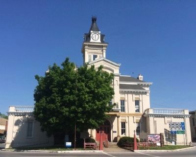
On Public Square at Jamestown Road (Kentucky Route 80), on the left when traveling north on Public Square.
On June 28, 1802, court ordered permanent seat of justice on the public square. First courthouse built in 1806. Present structure was designed by McDonald Bros., Louisville, and built by Wm. H. Hudson and Columbus Stone in 1887. A unique . . . — — Map (db m83384) HM
On Public Square at Campbellsville Street (Kentucky Route 55), on the left when traveling east on Public Square.
A foremost champion of the Union, a staunch friend of the stricken South, defender of constitutional freedom. Born Columbia 1817, died 1895 and buried in city cemetery. Veteran Mexican War, leader famed First Kentucky Union Cavalry, hero of many . . . — — Map (db m83387) HM
On Burkesville Street (Kentucky Route 80) at Church Street, on the right when traveling south on Burkesville Street.
Active Presbyterian congregations formed early in the county’s settlement: 1803 on Col. Casey’s farm & 1827 in Columbia. Church was built in 1857 and has had continuous services ever since. County and city congregations merged in 1912. . . . — — Map (db m170507) HM
On Public Square at Burkesville Street (Kentucky Route 80), on the right when traveling south on Public Square.
General John Hunt Morgan's cavalry, returning from second Kentucky raid, passed here on way back to Tennessee, Jan. 1, 1863. On raid, Union's rail supply line wrecked and $2,000,000 property destroyed. July 3, 1863, Morgan here again drove out . . . — — Map (db m83391) HM
On Greensburg Street (Kentucky Route 439) at Public Square, on the left when traveling south on Greensburg Street. Reported missing.
For Gen. John Adair, Governor of Kentucky 1820-24. Born, 1757, in South Carolina, came to Ky., 1788. Member of Kentucky Constitutional Convention, 1792. Served in Ky. House of Representatives, 1793-95, 1798, 1800-03, 1817. US Senator, 1805-06, . . . — — Map (db m139816) HM
On Jamestown Road (Kentucky Route 80) at Elm Street, on the right when traveling north on Jamestown Road.
A founder of Columbia, Trabue built original house (SW corner of this structure) ca. 1823. He served as trustee, sheriff, and justice of peace; operated grist mill, inn and retail store. Here Trabue wrote memoirs, 1827, of pioneer era, which . . . — — Map (db m83406) HM
On Greensburg Street (Kentucky Route 439) at Public Square, on the right when traveling south on Greensburg Street.
Girlhood home of Jane Lampton (1803-1891). Wife of John Marshall Clemens. Mother of "Mark Twain." Granddaughter of Colonel William Casey, original Adair County settler. — — Map (db m83397) HM
On East Guardian Street, on the right when traveling south.
Male and Female High School Site
The Columbia College Joint Stock Company formed in 1853 to build the M&F School. It was conveyed to trustees appointed by Transylvania Presbytery and opened in 1855. The building was a Union Camp during . . . — — Map (db m170509) HM
On Sprout Springs Road at Elkhorn Road (Kentucky Road 76), on the right when traveling south on Sprout Springs Road.
Historical novels by this talented author have sold more than three million copies. Most settings of her some twenty books reflect her adopted home, the Green River area where she lived with her husband Henry, and the Indian territory of Okla. and . . . — — Map (db m245361) HM
On Old Glasgow Road (Old U.S. 31E) at Durham Spring Road, on the left when traveling north on Old Glasgow Road.
Bethlehem Missionary Baptist Church
Congregation founded 1801. Services held, uninterrupted, except for a Sunday in Nov. 1862, because of "Army passing down the pike and the house having sick soldiers in it." Called "Difficult" and located near . . . — — Map (db m143077) HM
On West Main Street (Kentucky Route 2152) west of South Cemetery Street, on the right when traveling west.
Confederate forces of 200 under Col. John M. Hughs attacked here, Dec. 8, 1863. Twelve days earlier he had attacked Monticello, Ky., captured then paroled garrison of 153 men; no supplies. Continuing to harass USA forces, seek stores[,] he came . . . — — Map (db m170511) HM
On West Main Street (Kentucky Route 2152) west of South Cemetery Street, on the right when traveling west.
For Lieut. Col. John Allen, born in Va., 1771, came to Ky., 1779. Practiced law in Shelby County. State Representative, 1801-07, and State Senate, 1807-13. Killed in battle at River Raisin, Jan. 22, 1813, and one of nine officers at that battle for . . . — — Map (db m131262) WM
On West Main Street (Kentucky Route 2152) west of Smiths Grove Road (Court Street), on the right when traveling east.
Built in 1919 during an oil boom, Jacksonian gained wide prominence. It was third hotel on site and stood here for 54 years. Closed, 1973. Hotel received name because of its location on Jackson Highway, now 31-E, one of oldest roads in Kentucky. . . . — — Map (db m131260) HM
On Bowling Green Road, 0.2 miles north of Whetstone Way, on the right when traveling north.
Mt. Union Church
Organized in 1864 under the name of Mulberry Hill General Baptist Church. In 1869 the original log building burned. The congregation rebuilt on present site, changed the name to Mt. Union. Thirteen churches were invited from . . . — — Map (db m143075) HM
On South 1st Street at East Locust Street, on the right when traveling north on South 1st Street.
Allen County was formed in April 1815. Scottsville was named for Gen. Charles Scott, 4th governor of Ky. In 1816, location was chosen for county seat because of abundant water supply from this spring. County bought 100 acres, which were laid off in . . . — — Map (db m143071) HM
On Pope Road (County Route 1332) 0.1 miles west of Jenny Lane, on the left when traveling west.
The Trammel Fork Church was founded in 1802 with seventy members. Elder John Hightower was first pastor. This church was instrumental in constituting ten area churches. The first meeting house was a log structure; church now occupies its third . . . — — Map (db m143073) HM
On South Main Street (Business Kentucky Route 127) at East Court Street, on the right when traveling north on South Main Street.
This Lawrenceburg native was one of the first black women in Ky. to enlist during World War II. She joined Women's Army Auxiliary Corps in 1942, and was commissioned a 1st Lieutenant the next year in newly named Women's Army Corps. While . . . — — Map (db m229583) HM
On East Woodford Street (U.S. 62) near Dogwood Drive, on the left when traveling east.
Kavanaugh School.
Rhoda C. Kavanaugh founded school on Woodford Street which became known as "Little Annapolis." First boarding student came to prepare for Naval Academy in 1914. From then until 1945, Mrs. Kavanaugh launched 150 future Navy . . . — — Map (db m236572) HM
On East Woodford Street (U.S. 62) east of Dogwood Drive, on the right when traveling west.
Kavanaugh Academy 1904-09; Anderson Co. High School 1909-20; Kavanaugh High School 1920-49. Rhoda C. Kavanaugh, A.B., founder and principal 41 years. Under her direction it ranked among the nation's foremost preparatory schools for Annapolis and . . . — — Map (db m236573) HM
James Beauchamp (Champ) Clark born near here, 1850. Attended U. of K. Taught school in county, 1870-71. Pres. Marshall College, 1873-74. Congressman from Missouri 24 yrs. Led defeat of Cannonism, control of House by Speaker. Then Speaker, 1911-19. . . . — — Map (db m313) HM
On West Broadway Street (U.S. 62) at Old Frankfort Road (U.S. 127), on the right when traveling west on West Broadway Street.
This renowned scholar, raconteur, and lawyer was born in Anderson Co. Educated first in a one-room school at Glensboro, he graduated from U.K. Law School in 1912. Among his books was Lincoln and the Bluegrass (1955). His talk on Cassius Clay, . . . — — Map (db m34786) HM
On Paducah Road (U.S. 60) 0.4 miles east of Stafford Road, on the right when traveling east.
Settled by Scott family ca. 1845. Developed from family farmstead to highly diversified & productive cattle, jack stock and mule ranch. In 1998, recognized by National Cattlemen's Beef Assoc. as one of the oldest cattle ranches in U.S. under . . . — — Map (db m216302) HM
On 4th Street (U.S. 51/62), on the right when traveling north.
For Capt. Bland Ballard, 1759-1853. Born in Va. Came to Ky. in 1779. Devoted life protecting frontier. Scout for George Rogers Clark's Ohio expedition, 1780. '82; Wabash campaign 1786. In the battles of Fallen Timbers, 1793; Tippecanoe, 1811; River . . . — — Map (db m18550) HM
On Westvaco Road (U.S. 51/62), on the right when traveling south.
Fort Jefferson Site Built in 1780 by George Rogers Clark as part of impressive plan of settlement, conceived by Gov. Patrick Henry of Virginia, later pursued by and named for Gov. Thomas Jefferson. The fort was to protect US claim to its . . . — — Map (db m18639) HM
On Westvaco Road (U.S. 51/62), on the right when traveling south.
(North Side):Lewis and Clark in Kentucky Fort Jefferson Lewis and Clark and a party of eight men visited the site of Fort Jefferson on Nov. 18, 1803, while on their epic 1803-1806 journey to the Pacific. Fort est. in 1780 by Clark's . . . — — Map (db m18545) HM
On Green Street (U.S. 51/62), on the right when traveling south.
(North Side):The Prince of the French Explorers Commissioned by Louis XIV of France, the Sieur Robert de LaSalle, sweeping down the Mississippi with his flotilla of canoes, stopped in 1682 at this place, in his quest for the mouth of the . . . — — Map (db m18551) HM
On Westvaco Road (U.S. 51/62), on the right when traveling south.
One of first Kentucky positions, Fort Jefferson, occupied by Union troops after Confederate seizure of Columbus, Sept. 1861. From this base, Gen. U.S. Grant directed demonstration against Columbus, Jan. 1862. Troops from here joined in capturing Ft. . . . — — Map (db m18519) HM
On W. Broadway Street (State Highway 70) near N. 1st Street, on the right when traveling west.
CSA General John Hunt Morgan and a company of troops arrived here, May 11, 1862. They seized a train reported to be carrying some of Morgan's men captured at Lebanon, Tenn. Instead, it carried railroad employees whom he released. Morgan burned the . . . — — Map (db m321) HM
On W. Broadway Street (State Highway 70) at N. 1st Street, on the right when traveling west on W. Broadway Street.
Confederate Brigadier General, commanded famous “Orphan Brigade” in Civil War. In 1861 he conducted recruiting and training camp here. State legislature, 1850-54, 69-70. US Congress, 1870-73. Member of Kentucky Court of Appeals for 24 years, . . . — — Map (db m96727) HM
On Green Street at Main Street, on the left when traveling north on Green Street.
Taken from parts of Green and Warren counties. Glasgow, county seat, was founded in 1799. County received name from the “barrens” or prairies of this region.
Early explorers and settlers came through this area. In Civil War, first . . . — — Map (db m88132) HM
On Race Street (West Public Square) (Business U.S. 68) north of Washington Street, on the left when traveling south.
On Dec. 24, 1862, main body of Morgan's Raiders made camp south of here. Capt. Quirk and scouts entered town although USA troops patrolled area. CSA scouts wished to celebrate Christmas Eve, and dismounted at tavern. A patrol of 2nd Mich. Cavalry, . . . — — Map (db m73020) HM
On Race Street (West Public Square) (Business U.S. 68) north of Washington Street, on the left when traveling south.
(side 1)
Confederate Congressional Medal of Honour
The President (CSA), in 1862, was authorized to confer a Medal of Honour upon one enlisted man of each company for “every signal victory.” At first dress-parade, . . . — — Map (db m73018) HM
On Coral Hill-Lecta Road at Coral Hill Road (Kentucky Route 740), on the right when traveling east on Coral Hill-Lecta Road.
In 1855, John and Francis Marion Jones formed a partnership for selling goods at Myers Steam Mill on Beaver Creek in Barren County. A petition for a post office was granted in 1856 & name changed from Myers Mill to Coral Hill. Store was catalyst . . . — — Map (db m143082) HM
On N. Jackson Highway (U.S. 31E) 0.1 miles north of Horton Rigdon Road, on the right when traveling north.
On Jan. 12, 1939, the Goodnight substation was energized. The circuit powered 107 homes along 51 miles of power line in Barren Co. This substation was the first in Farmers RECC service territory. Electricity improved rural life, increased . . . — — Map (db m96997) HM
On S. Broadway Street at E. Washington Street, on the right when traveling north on S. Broadway Street.
Congregation formed ca. 1802, when Isaac Robertson, a member, donated lot for log structure erected here. Rev. John Howe was first minister. Present Gothic Revival sanctuary built ca. 1853. Church’s style of architecture features Tudor-arched window . . . — — Map (db m88133) HM
On N.L. Rodgers Wells Boulevard (Bypass U.S. 31-E) at Cross Street, on the right when traveling north on N.L. Rodgers Wells Boulevard.
Site of Civil War fort built in spring of 1863. Attacked Oct. 6 by Confederate Col. John M. Hughs and his 25th Tenn. Infantry. US troops under Maj. Samuel Martin surprised. Over 200 horses captured, part of fort burned, and 142 men taken prisoner, . . . — — Map (db m39405) HM
On Tompkinsville Road (Kentucky Route 63) at Bristletown Road, on the left when traveling north on Tompkinsville Road.
Henry Clay Morrison
Famed Methodist preacher & pioneer of the Holiness movement. He came to Barren Co. at age 2 & was raised by his grandparents near here. He became one of nation’s premiere evangelists and was editor of the Pentecostal Herald . . . — — Map (db m143080) HM
On E. Main Street (State Highway 90) 0.1 miles east of Franklin Street, on the right when traveling west.
(Side One)
Home of Arthur Krock
Called dean of Washington newsmen, Glasgow’s native son (1886-1974) grew up here with his grandparents, Emmanuel and Henrietta Morris. He began his career in journalism with the Louisville . . . — — Map (db m87980) HM
On E. Main Street (State Highway 90) east of Franklin Street, on the right when traveling west.
Preston H. Leslie, born Ky., 1819. Died Montana, 1907. Completed term of Gov. John Stevenson from Feb. to Sept., 1871, when elected 27th Governor of Kentucky. Known for his sound judgment of State affairs and meeting the needs of growing population . . . — — Map (db m87981) HM
On U.S. 31 E at Lexington Drive, on the right when traveling south on U.S. 31 E.
Henry Skaggs and two companions trapping beaver, winter 1770-71, were probably first white men in this area. Named Long Hunters due to long period away from home in the East. Came through Cumberland Gap, 1769, in party led by James Knox. Skaggs’ . . . — — Map (db m87978) HM
On Washington Street / South Public Square at South Race Street, on the right when traveling east on Washington Street / South Public Square.
Born in Hiseville (Barren Co.). Graduate of Kentucky State Univ.; later member of Board of Regents. Also studied at Indiana Univ. and Peabody Coll. As principal of Ralph J. Bunche School, Twyman led its merger with Glasgow High School to achieve . . . — — Map (db m82469) HM
On Race Street at Washington Street, on the left when traveling south on Race Street.
(Front Side)
The first female public official in Barren Co., she was elected in 1913, seven years before women were allowed to vote. She was Barren Co. schools superintendent from 1914-1917. Instrumental in unifying local schools to . . . — — Map (db m88116) HM
On Finney Road (Kentucky Route 252) 0.1 miles Old Kentucky Road 252, on the left when traveling east.
Prized by frontiersmen, now rare collectors' items; they were made by three Settle generations in Barren County. Starting in 1800, William made flintlocks at Rocky Hill. A son, Felix, had shops in Glasgow, Roseville. Felix's sons, Simon and Willis, . . . — — Map (db m143078) HM
On Race Street at Washington Street, on the left when traveling south on Race Street.
This Glasgow native was the first African American woman to earn a pilot’s license in the U.S., 1937. That year, she also earned masters degree from Northwestern Univ. She was first African American officer in Civil Air Patrol (1941) & first . . . — — Map (db m88118) HM
On Hiseville-Park Road (State Highway 740) at Seymour-Park Road (State Route 571), on the right when traveling north on Hiseville-Park Road.
Civil War’s first Kentucky Federal death, Oct. 10, 1861, 4 miles east. A Union company slipped through the graveyard at night to arrest C.B. Hutcherson, a local Southern sympathizer. Ten poorly equipped recruits from CSA camp of Gen. Joseph Lewis, . . . — — Map (db m97001) HM
On North Jackson Highway (U.S. 31E) 2.3 miles south of Kentucky Route 218, on the left when traveling south. Reported missing.
On CSA invasion of Kentucky, resulting in battle of Perryville, Gen. Leonidas Polk’s wing moved thru here, Sept. 16, 1862, to attack USA troops at Munfordville.
Two of Kentucky raids by CSA Gen. John Hunt Morgan’s cavalry routed thru here, . . . — — Map (db m79208) HM
On Old Dixie Highway (State Highway 255) west of J. Brown Road, on the right when traveling east.
Erected by Wm. Bell, 1830. Stage stop for his lines that brought visitors to Mammoth Cave when first promoted. Famed in U.S. and Europe for elite patrons, cuisine and magic peach and honey brandy for “Joy before the journey’s end”, until it burned . . . — — Map (db m96715) HM
Near Mammoth Cave Parkway (State Highway 255) 1.3 miles north of Interstate 65, on the right when traveling north.
On July 14, 1859, a slave was lowered into a pit discovered on the farm of Jesse Coats. He saw glistening calcite crystals that he thought were diamonds. The first public tour was made by a wedding party on August 19, 1859. Guidebooks were written . . . — — Map (db m96712) HM
On Bethel Ridge Road, on the left when traveling north.
Longview Cemetery, Bethel, is grave site of one of the most noted and best-loved Kentucky journalists. Born 1918 in Benton, he gained renown from his column, "Joe Creason's Kentucky," in the Louisville Courier-Journal. His popular book by same name . . . — — Map (db m110166) HM
On U.S. 60 at Old River Road, on the left when traveling west on U.S. 60.
Caney Furnace
Stood five miles south. This stone stack, built 1837-38 by Harrison Connor and Joshua Ewing, Sr., was among first iron furnaces west of the Alleghenies to be equipped with a hot-blast oven, a device to preheat the air blown . . . — — Map (db m110123) HM
On Kentucky Route 36 just south of Olympia Spring Road and Old State Road, on the left when traveling north.
This famous resort, known by 1791
as Mud Lick Springs, was favored
for a century by such prominent
visitors as Henry Clay. First
stagecoach route in Kentucky began in
1803 between here and Lexington.
Many Lexingtonians fled here . . . — — Map (db m146665) HM
Formed from Montgomery County, 1811. Named for its many mineral springs. The birthplace of CSA Gen. John B. Hood and US Senator Richard H. Menefee. Owingsville named for Col. Thomas D. Owings. Organizer US 28th Inf. Reg., 1812. Associate in . . . — — Map (db m26286) HM
On Kentucky Route 36, on the left when traveling north.
Bourbon Iron Works Jacob Myers from Richmond, Va. took up land grants here on Slate Creek, 1782. He built the first iron blast furnace in Ky., 1791. John Cockey Owings and Co. formed to operate furnace. Utensils and tools supplied settlers. . . . — — Map (db m110121) HM
This famous Revolutionary War hero, who rode 40 mi. to warn Jefferson, Patrick Henry and other legislators of British approach, June 3, 1781, is buried in Bath Co. Jack Jouett of Va. galloped all night from Cuckoo Tavern to Monticello to . . . — — Map (db m26285) HM
Twenty-two Kentucky courthouses were burned during the Civil War, nineteen in last fifteen months: twelve by Confederates, eight by guerillas, two by Union accident. See map on reverse side.
March 21, 1864, Union troops fled courthouse here as . . . — — Map (db m79185) HM
On East Main Street (U.S. 60), on the right when traveling west.
John Bell Hood, 1831-79, graduate of West Point, 1853. Eight years Indian campaigns. Resigned, 1861, and joined CSA as colonel, heading Texas Brigade. Gained distinction at Sharpsburg, Fredericksburg, 1862, and at Gettysburg, Chickamauga, 1863. . . . — — Map (db m110149) HM
On West Main Street, on the left when traveling west.
Owings House
Built 1811-14 for Colonel Thomas Dye Owings by Benjamin Latrobe, who redesigned the interior of the US Capitol after the British burned it, War of 1812. This house was a center of social life during early 1800's. Henry Clay, . . . — — Map (db m110150) HM
On Main Street (Kentucky Route 211), on the right when traveling north.
Clear Creek Furnace
Built in 1839, 5 miles south, by W. A. Lane and W. S. Allen. Stone stack originally 40 ft. high and 10 1/2 ft. across inside, burning charcoal. Air blast powered by steam. Its iron was used mainly for railway car wheels. . . . — — Map (db m110122) HM
On Camp Street, on the right when traveling south.
Born in Sharpsburg on April 13, 1859, Allen attended Peeks Mill Military Academy and Georgetown College before graduating from the United States Military Academy at West Point in 1882. He was sent to the western frontier, where he led an expedition . . . — — Map (db m110168) HM
On State Highway 190 at U.S. 25E, on the right when traveling east on State Highway 190.
Rev. Hiram M. Frakes founded this Methodist Settlement in 1925. Begun in a cabin with 13 students, it became an institution for spiritual and educational development of mountain youth. Frakes guided and influenced the entire Middle Laurel Fork . . . — — Map (db m162490) HM
Near Old Wilderness Road (Kentucky Route 988) at Pinnacle View Road, on the right when traveling north.
During the Civil War, Cumberland Gap was held alternately by Union and CSA armies. USA forces under Gen. George W. Morgan occupied it June 18 to Sept. 17, 1862. Cut off from supplies and surrounded, Morgan with 9,000 men retreated successfully to . . . — — Map (db m50230) HM
On North 24th Street at Gloucester Avenue, on the right when traveling north on North 24th Street.
Grave of Colonel Arthur Campbell (1743-1811). Statesman, revolutionary soldier, justice, legislator, county lieutenant. Sons, James and John killed in War of 1812. — — Map (db m57938) HM
Near Old Wilderness Road (Kentucky Route 988) at Pinnacle View Road, on the right when traveling north.
(side 1)
Cumberland Gap
Providing a viable transportation route through the rugged terrain of the Appalachian Mountains, the Cumberland Gap was valued by both Union and Confederate armies during the Civil War. Along with the East . . . — — Map (db m181079) HM
Meriwether Lewis, coleader of the Lewis & Clark Expedition, with a party of Expedition veterans and a Mandan Indian delegation, went through Cumberland Gap in Nov. 1806 en route to Washington to report on the expedition. Over.
Cumberland . . . — — Map (db m33299) HM
Near North 28th Street, 0.2 miles north of Cirencester Avenue, on the left when traveling north.
One of the oldest in US, founded 1889. The present nine-hole course located on site where original was laid out by the English developers who came 1886 and brought the golf game to this mountain region. In 1899, a financial crash in England took . . . — — Map (db m181083) HM
On 12th Street (U.S. 25E), on the right when traveling north.
Designated by the Kentucky Society of Professional Geologists as a Distinguished Geological Site. Middlesboro is one of only a few cities on the North American Continent located in the basin of a meteorite impact structure.
Sometime over the . . . — — Map (db m33296) HM
On North 20th Street south of Lothbury Avenue, on the right when traveling south.
English colony founded in 1886 by Alexander Arthur. Project financed by English company, the American Association, because of timber and rich mineral deposits here. Almost 100,000 mountainous acres in Va., Tenn., and Ky. purchased for the . . . — — Map (db m33297) HM
Alexander Arthur, 1846-1912, an outstanding figure in history of Middlesboro. He came here in 1885 to prospect, discovering coal and iron ore deposits. President of American Association, formed to carry out his plans for a mining and manufacturing . . . — — Map (db m33298) HM
On 19th Street (Route 2079) at Hurst Road, on the right when traveling north on 19th Street.
Built about 1800 in Yellow Creek Valley, the second brick house in the county, and the oldest one still standing. The bricks were made from clay by slave labor. Home of Rev. John Calvin Colson, "Patriarch of Yellow Creek Valley," preacher, teacher, . . . — — Map (db m181081) HM
On 12th Street (U.S. 25E) at 14th Street East, on the right when traveling south on 12th Street.
Watts Furnace
Stood ½ mile SW. A pair of blast furnaces built by the Watts Steel and Iron Syndicate, Ltd., 1890-93, and operated until 1898. Each iron shell stack was 75 ft. high with a maximum inner diameter of 17 ft. Using coke fuel and . . . — — Map (db m170830) HM
On Bob Madon Bypass (U.S. 25E) at Pine Street (State Highway 66), on the right when traveling west on Bob Madon Bypass.
One of the most important points on the Wilderness Road marked by Daniel Boone in 1775. Ford first used by Indians, then by early explorers and the Long Hunters. After Boone opened the way west, more than 100,000 settlers used the crossing as a . . . — — Map (db m35831) HM
On Kentucky Avenue at Pine Street (Kentucky Highway 66), on the right when traveling east on Kentucky Avenue.
Bell County formed from Harlan and Knox Counties, 1867. Named for Joshua Fry Bell, 1811-70, Congressman, Ky. Sec. of State, Comr. to peace conference in 1861 and State Legislator. He was g. grandson of Dr. Thomas Walker, explorer of Ky. . . . — — Map (db m35871) HM
On Bob Madon Bypass (U.S. 25E) south of Park Avenue, on the left when traveling south.
Opened Kentucky and the West to rapid settlement and major development. First wagon road built by Kentucky (1796), Crab Orchard to Cumberland Gap. A principal highway, maintained as turnpike (toll road) for 80 years. — — Map (db m212442) HM
On Bob Madon Bypass (U.S. 25E) at Tennessee Avenue, on the right when traveling west on Bob Madon Bypass.
The first to begin operations in Bell County, starting in 1889, with 1500 acres of coal land. Extension of the Louisville and Nashville Railroad to this area in 1888 marked the beginning of a new industrial era. This mine was not a financial . . . — — Map (db m35854) HM
On Bullittsburg Church Road (Kentucky Route 8) near Interstate 275, on the left when traveling north.
It has been called the "Mother
Church" because from 1800-1915
its members organized other
churches within the tri-state area.
Between 1871 and 1873, an outdoor
keyhole baptismal pool was built
of stone masonry at the site of a
natural . . . — — Map (db m133224) HM
On Kentucky Route 18 at Kentucky Route 338, on the right when traveling west on State Route 18.
In June 1799, Boone County's first
court set Craig's Camp as county
seat. The next year, John H. Craig and Robert Johnson donated 74 acres at the Woolper Creek site for a town they called Wilmington. Court held here in a log courthouse in Jan. . . . — — Map (db m133144) HM
Near Sperti Lane, on the right when traveling south.
Born in Covington to Italian
immigrants, he graduated from
the University of Cincinnati
in 1923. He was the director of
Institutum Divi Thomae, a medical
research foundation, from 1935 to
1988. Sperti invented well-known
pharmaceutical . . . — — Map (db m133141) HM
On Brlngon Pike (Kentucky Route 18), on the right when traveling south.
James and Martha Macomb Dinsmore
moved from La. to raise their three
daughters here. Completed in1842,
the main house served as the center
of a typical large, antebellum Boone
Co. farm. tenants and slaves raised
grains, grapes, sheep, and . . . — — Map (db m79304) HM
Formed by legislative act from a part of Campbell County. Names for Daniel Boone, renowned Kentucky pioneer-explorer.
Big Boone Lick, graveyard of the mammoth, was discovered in 1729 by Capt. M. de Longueil. In 1756, Mary Inglis was brought . . . — — Map (db m61867) HM
On Center Street at Girard Street, on the right when traveling north on Center Street.
First Baptist African American
Church in Florence was founded
in 1870 by the Trustees of the
Colored Baptist Association. The
congregation was active for over
100 years and was essential to
formerly enslaved people & Freedmen
in the area. . . . — — Map (db m180718) HM
On Hopeful Church Road (Kentucky Route 842) east of Clayton Road, on the right when traveling east.
Hopeful Evangelical Lutheran
Church was founded on Epiphany
Day. 1806. by German-speaking
families from Madison County, Virginia.
Called “the Mother of Lutheranism
west of the Allegheny Mountains,”
it is the oldest Lutheran church . . . — — Map (db m136081) HM
On Main Street at Dixie Highway (U.S. 42), on the right when traveling east on Main Street.
John Uri Lloyd (1849-1936). Born in NY, came to Boone Co. KY in 1853. Pharmacist, chemist, inventor & electric herbal medicine pioneer. Wrote series of novels based on local folklore including Stringtown on the Pike in 1900. Founded . . . — — Map (db m201104) HM
On Dixie Highway (U.S. 25) at U.S. 42, on the right when traveling south on Dixie Highway.
Union troops, had built forts around Covington to repel expected attack from CSA troops under Gen. Heth. Detachment of 101 CSA troops camped at Snow's Pond attacked here by scouting party of 53 USA cavalrymen Sept. 17, 1862. In the skirmish 1 Union, . . . — — Map (db m133190) HM
On Kentucky Route 8, on the left when traveling east.
1937 Flood at Constance
The Ohio River reached its peak
on Jan. 26 at 79.9 ft. surpassing
the 1884 record. Constance was the
hardest hit town in Boone Co. but
there were no fatalities. Route 8
between Constance & Taylorsport
was almost . . . — — Map (db m133629) HM
On Kentucky Route 8, on the right when traveling east.
American Airlines flight 383, tail
#N1996, was making an approach
in rain when it crashed into this
hillside on November 8, 1965 at
7:01 p.m. The 3-engine Boeing 727
Astrojet was en route from New York
to Cincinnati. 58 people perished
four . . . — — Map (db m133173) HM
On Petersburg Road (Kentucky Route 20) at Aviation Boulevard, on the left when traveling east on Petersburg Road.
TWA flight 128, tail #N821TW, was
making an approach in light snow
when it crashed into an orchard
approximately 1,000 feet north of
here, on November 20. 1967 at 8:57
p.m. The four-engine Convair 880
was en route from Los Angeles . . . — — Map (db m133136) HM
On North Bend Road (Kentucky Route 237) at Wright Boulevard, on the right when traveling south on North Bend Road.
TWA flight 694, tail #N93211, had taken off from the airport when
it was struck by a private DC-3
& fell to the ground approximately
750 feet west of here, on January
12, 1955 at 9:04 a.m. The TWA
Martin 202A was en route to
Cleveland, Ohio . . . — — Map (db m133123) HM
On Belleview Road (Kentucky Route 20/3608) 0.4 miles east of Mill Street, on the right when traveling north.
Charles Clinton Fleek (1947-1969). Sergeant Charles Clinton "Chalkie" Fleek was born on August 28, 1947 in Petersburg, KY. He served in the U.S. Army 25th Infantry Division in South Vietnam and is the only medal of Honor recipient from Boone . . . — — Map (db m201099) HM
On Front Street west of Tanner Avenue, on the right when traveling south.
Lewis Loder (1819-1905). Born in Pennsylvania, he moved to Petersburg in 1858 and lived in a c. 1840 house at Tanner & Front Sts. He served as justice of the peace and operated a tavern in his home for many years. Loder was hired as clerk & . . . — — Map (db m133205) HM
On Tanner Street (Kentucky Route 0) at 3rd Street, on the right when traveling south on Tanner Street.
First settlement in Boone County. Rev. John Tanner built blockhouse, and town began on 2000 acres he and John Taylor owned. Shawnees captured Tanner’s 9-year-old son here, held him until grown. An ardent Baptist, Tanner preached in Carolinas, . . . — — Map (db m79310) HM
On Richwood Road (Kentucky Route 338), on the right when traveling west.
Home site of John Pollard Gaines.
1795-1857. Fought in War of 1812.
In state legislature, 1825-36.
Major in the 1st Kentucky Cavalry and
an aide-de-camp to Gen. Winfield
Scott, in Mexican war. Elected to
Congress, 1847-49, while prisoner
of . . . — — Map (db m133213) HM
On Route 338 at Richwood Church Road, on the right when traveling west on Route 338.
Services have been held by this
old church continuously since it
was founded in 1834 by Joseph
Cabell Harrison, first pastor. He
and cousin John Breckinridge in
1824 founded early religious paper
in Ky. A cousin of Pres. William
H. . . . — — Map (db m133216) HM
On Ryle Road at Boat Dock Road (Kentucky Route 1925), on the right when traveling south on Ryle Road.
Discovered in 1739 by French Capt. Charles Lemoyne de Longueil. Early explorers found countless bones and teeth of extinct Pleistocene elephants, the mammoth and the mastodon. This saline-sulphur spring was popular for salt making until 1812: also a . . . — — Map (db m175117) HM
On U.S. 42 near Old Union Road, on the right when traveling west.
On Nov. 28, 1863, after escaping
from Ohio Penitentiary & taking a
train to Cincinnati, CSA Gen. John
Hunt Morgan & Capt. Thomas Hines
crossed the Ohio River to Ludlow.
Sympathetic Boone County residents,
as well as Big Bone Baptist . . . — — Map (db m136082) HM
On Beaver Road west of Route 127, on the right when traveling west.
Lewis and Clark in Kentucky Big Bone Lick
In Oct. 1803, while traveling down Ohio River to meet Wm. Clark for expedition to Pacific, Meriwether Lewis visited Big Bone Lick. He was to gather fossilized bones for Pres. Thomas Jefferson. In . . . — — Map (db m79062) HM
On Beaver Road west of U.S. 127, on the right when traveling west.
Reputed first white woman in Ky.
Shawnees captured her and two sons
in July 1755 at site Roanoke, Va.
Led to village at mouth of Scioto River,
separated from sons, taken to Big
Bone Lick. compelled to make salt
here; adopted by chief; given . . . — — Map (db m79071) HM
On Lower River Road, on the left when traveling west.
Piatt's Landing
Near here on the north bank of the
Ohio River at mile 510.5 was a
riverboat landing, ferry, and road
to the courthouse at Burlington.
The landing and large brick home
that once stood near, later called
Winnfield . . . — — Map (db m79142) HM
On Old Nicholson Road north of Main Street (U.S. 25), on the right when traveling north. Reported missing.
In 1790s Abner Gaines built this Federal-style mansion and became owner of first stage line between Lexington and Cincinnati, 1818. House used as inn and stagecoach stop. It has 3 stairways and 10 carved mantels. Abner’s son, John P. Gaines, was . . . — — Map (db m136083) HM
On Dixie Highway (U.S. 25) 0.3 miles south of Logistics Boulevard, on the left when traveling south.
During 1862 Confederate invasion,
rebel forces under General Basil W
Duke searched for approaches to
Cincinnati. On September 25, 1862,
over 500 attacked a federal camp
here commanded by Brig. Gen. Quincy
A. Gillmore. Many USA . . . — — Map (db m133217) HM
1845 entries matched your criteria. The first 100 are listed above. Next 100 ⊳