By William Fischer, Jr., October 31, 2015
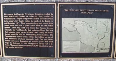
Lewis & Clark Expedition Marker
GEOGRAPHIC SORT Title Sort Marker Number Sort Marker Number Sort N Marker Number Sort T Publication Order Sort Publication Order Sort A Erected Year Sort Most Viewed Sort Most Recent-Interest Sort Most Recently Changed Sort SEE FAQ #33 FOR DESCRIPTIONS
On Lincoln Way at Park Street on Lincoln Way.
On Gulf Street at Cherry Street, on the right when traveling south on Gulf Street.
Near E Fort King St, 0.1 miles south of E Silver Springs Blvd..
On Julia Davis Drive, on the right when traveling west.
On U.S. 12, 1.5 miles south of State Highway 11, on the right when traveling west.
Near U.S. 12 at 140th Street, on the right when traveling west.
Near U.S. 12 at 140th Street, on the right when traveling west.
Near U.S. 12 at 140th Street, on the right when traveling west.
Near U.S. 12 at 140th Street, on the right when traveling west.
On U.S. 12, 3 miles south of Michigan Avenue, on the right when traveling west.
Near U.S. 12 at 140th Street, on the right when traveling west.
On West Pierce Street (State Highway 11 at milepost 17) near West 7th Street, on the right when traveling east.
On Camas RoadCe near Cemetery Road.
Paid Advertisement
On Camas Road near Cemetery Road, on the right when traveling east.
On Woods Street at West Pierce Street (State Highway 11), on the right when traveling east on Woods Street.
On West Pierce Street (State Highway 11) near West 7th Street.
On West Pierce Street (State Highway 11 at milepost 17) near West 7th Street, on the right when traveling east.
On Larson Road near Cemetery Road, on the right when traveling east.
On U.S. 95 at Airport Road, on the right when traveling north on U.S. 95.
On Lolo Motorway (Forest Road 500) near Weites Butte Lookout Road, on the left when traveling west.
On Lolo Creek Road near Buckner Creek Road, on the right when traveling west.
On Forest Road 500 near unnamed road, on the left when traveling south.
On Forest Road 500 near Forest Road 514, on the left when traveling south.
On Lolo Motorway (Forest Road 500) at Smith Creek Road on Lolo Motorway.
Near Lake Road near Tolo Lake Road, on the left when traveling south.
On U.S. 12, 0.5 miles west of Dyche Road, on the left when traveling west.
On U.S. 12 at milepost 158 near Forest Road 1684, on the left when traveling west.
On U.S. 12 at milepost 158 near Forest Road 1684, on the left when traveling west.
On U.S. 12, 27.7 miles east of Mill Road, on the right when traveling east.
Paid Advertisement
On U.S. 12 at State Highway 13, on the left when traveling east on U.S. 12.
Near Highway 12 near Elk Meadows Road, on the left when traveling east.
Near Powell Road (Forest Road 102) near U.S. 12.
On Elk Meadows Road (Forest Road 373) near Forest Road 5950, on the right when traveling east.
On U.S. 12, 27.7 miles east of Mill Road, on the right when traveling east.
Near U.S. 12 at milepost 121, on the right when traveling west.
On Highway 12, 3 miles west of Elk Meadows Road, on the left when traveling east.
On U.S. 12, 4.6 miles east of Doe Creek Road, on the left when traveling east.
On Elk Meadows Road near U.S. 12.
On Lolo Motorway (Forest Road 500) near Liz Butte Road, on the left when traveling west.
On Lolo Motorway (Forest Road 500) near Forest Road 566, on the right when traveling south.
On Lolo Motorway (Forest Road 500) near Gravey Creek Road (Forest Road 107), on the left when traveling west.
On Casey Road (U.S. 93) near Carmen Creek Road, on the left when traveling north.
On Tower Rock Road near Redtail Lane, on the left when traveling east.
On Casey Road (U.S. 93 at milepost 315) near Tower Rock Road when traveling north.
On Tower Rock Road near Redtail Lane, on the left when traveling east.
Paid Advertisement
On Lewis and Clark Highway, Scenic (U.S. 93 at milepost 332), on the left when traveling north.
On U.S. 93 at milepost 345, on the right when traveling north.
On Casey Road (State Highway 93 at milepost 349) near State Highway 43, on the left when traveling north.
On South Railroad Street (State Highway 28) at Old Idaho 28 (State Highway 29), on the right when traveling east on South Railroad Street.
On Salmon River Highway (Scenic Route 30) 5 miles west of Lewis and Clark Highway (U.S. 93), on the left when traveling west.
On Lewis and Clark Highway (U.S. 93 at milepost 326.5) at Salmon River Road (Route NF 030), on the right when traveling south on Lewis and Clark Highway.
On Lewis and Clark Highway (U.S. 93 at milepost 326.1), 0.1 miles south of Salmon River Road (Route 30), on the left when traveling north.
On Salmon River Road (Forest Road 30) near Casey Road (U.S. 93), on the right when traveling west.
On State Highway 28 near Haynes Creek/17 Mile Road, on the right when traveling north.
Near Main Street (State Highway 28) near Kirtley Lane, on the right when traveling west.
On 17 Mile Road at Back Road (State Road 28), on the left when traveling east on 17 Mile Road.
On State Highway 28 near Haynes Creek/17 Mile Road, on the right when traveling north.
Near East Main Street (State Highway 28) 2 miles east of U.S. 93, on the left when traveling east.
Near Casey Road (U.S. 93) at Tower Creek Road, on the right when traveling north.
On Casey Road (U.S. 93) near Tower Rock Road, on the left when traveling north.
On State Highway 28 near Haynes Creek/17 Mile Road, on the right when traveling north.
Paid Advertisement
On Casey Road (U.S. 93) near Tower Rock Road, on the left when traveling north.
Near Forest Road 158 at Warm Springs Road (Forest Road 185) when traveling south.
Near Warm Springs Road (Forest Road 185) near Forest Road 158 when traveling south.
On Warm Springs Road (Forest Road 158) near Lewis and Clark Highway (Forest Road 013), on the right when traveling south.
Near Lemhi Pass Road near Lewis and Clark Highway (Forest Road 013), on the right when traveling south.
On Lewis and Clark Highway (Forest Road 013) near Forest Road 068, on the right when traveling west.
On State Highway 28 near Tendoy Lane.
On Warm Springs Road (Forest Road 158) near Lewis and Clark Highway (Forest Road 013), on the left when traveling south.
On Agency Creek Road near Forest Road 6238.
On State Highway 28 at Tendoy Lane, on the left when traveling north on State Highway 28.
On Agency Creek Road near Forest Road 6238, on the left when traveling west.
On State Highway 28 near Tendoy Lane, on the right when traveling north.
On Warm Springs Road (Forest Road 185), on the right when traveling east.
On Warm Springs Road (Forest Road 185) near Forest Road 186, on the right when traveling east.
On Agency Creek Road near Cow Creek, on the left when traveling west.
On Warm Springs Road (Forest Road 185) near Back Road (County Highway 28), on the left when traveling east.
Paid Advertisement
On Lemhi Pass Road near Forest Road 013, on the right when traveling east.
On U.S. 95 at milepost 268 near Evergreen Road when traveling north.
On U.S. 12, 0.5 miles west of Dyche Road, on the left when traveling west.
On U.S. 12, 0.3 miles north of Corbett Lane, on the left when traveling west.
On Snake River Avenue, 0.2 miles south of U.S. 12, on the right when traveling south.
On Snake River Avenue, 0.4 miles south of U.S. 12, on the right when traveling south.
On Snake River Avenue, 0.4 miles south of U.S. 12, on the right when traveling south.
On Snake River Avenue, 0.3 miles south of U.S. 12, on the right when traveling south.
On 3rd Street at Capital Street, on the right when traveling west on 3rd Street.
On Snake River Avenue, 0.3 miles south of U.S. 12, on the right when traveling south.
On Snake River Avenue, 0.3 miles south of U.S. 12, on the right when traveling south.
On Fort Defiance Road, on the right when traveling south.
On Washington Avenue (U.S. 60/62) south of U.S. 51, on the right when traveling north.
On Washington Avenue (U.S. 60/62) south of U.S. 51, on the right when traveling north.
On Washington Avenue (U.S. 60/62) south of U.S. 51, on the right when traveling north.
Paid Advertisement
On Washington Avenue (U.S. 51) north of 14th Street, on the right when traveling north.
On Washington Avenue (U.S. 60/62), on the right when traveling south.
On Washington Avenue (U.S. 51) at 15th Street, on the right when traveling north on Washington Avenue.
On Pecan Street south of Illinois Route 3, on the right when traveling south.
On Main Street at Washington Street, on the right when traveling north on Main Street.
705 entries matched your criteria. The first 100 are listed above.
Next 100 ⊳