6630 entries match your criteria. Entries 201 through 300 are listed.⊲ Previous 100 — Next 100 ⊳
Agriculture Topic
By Joseph Alvarado, October 11, 2022
Panel Next to the Marker
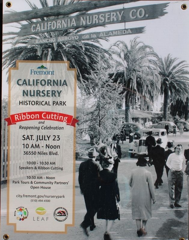
| 201 ► California, Alameda County, Fremont, Niles — California Nursery Historical Park Master Plan — |
| Near Nursery Avenue near Niles Avenue. | |||
| 202 ► California, Alameda County, Fremont, Niles — Gardens, Orchards & Plants — Historical Features — |
| Near Nursey Avenue near Niles Boulevard. | |||
| 203 ► California, Alameda County, Fremont, Niles — Legendary Nursery Innovators — Historical Features — |
| Near Nursey Avenue near Niles Boulevard. | |||
| 204 ► California, Alameda County, Fremont, Parkmont — The Shinn Family Nursery and Ranch — |
| On Peralta Boulevard at Robert Fisher Drive, on the right when traveling west on Peralta Boulevard. | |||
| 205 ► California, Alameda County, Fremont, Vineyards - Avalon — 642 — Leland Stanford Winery — |
| On Stanford Avenue near Vineyard Avenue, on the left when traveling east. | |||
| 206 ► California, Alameda County, Fremont, Vineyards - Avalon — The Curtner, the Silva and the Goularte Families — Rancho Higuera Historical Park — |
| On Rancho Higuera Road near Curtner Road, on the left when traveling south. | |||
| 207 ► California, Alameda County, Hayward — Agriculture Pioneer — Innovation and Prosperity — |
| Near Hampton Road near Boston Road. | |||
| 208 ► California, Alameda County, Hayward — Bay-Friendly Rated Landscapes in the City of Hayward — |
| On Whitesell Street at Bay Center Place, on the right when traveling south on Whitesell Street. | |||
| 209 ► California, Alameda County, Hayward — Cannery Park — Dedicated 1993 — Hayward Area Recreation and Park District — |
| Near Martin Luther King Drive near B Street. | |||
| 210 ► California, Alameda County, Hayward — Heart of the Estate — The Meek Mansion — |
| Near Boston Road near Hampton Road. | |||
| 211 ► California, Alameda County, Hayward — The Meek Mansion — |
| On Boston Road near Hampton Road, on the left when traveling north. | |||
| 212 ► California, Alameda County, Hayward — Working Farm — Outbuildings of the Estate — |
| Near Hampton Road near Boston Road. | |||
| 213 ► California, Alameda County, Livermore — Birth of an Industry — |
| 214 ► California, Alameda County, Livermore — 641 — Concannon Vineyard — |
| Near Tesla Road. | |||
| 215 ► California, Alameda County, Livermore — 586 — Cresta Blanca Winery — |
| Near Arroyo Road. | |||
| 216 ► California, Alameda County, Livermore — From Borax to Burgundy — |
| Near Wetmore Road. | |||
| 217 ► California, Alameda County, Livermore — Livermore Rodeo — World's Fastest — Since 1918 — |
| Near South Livermore Avenue. | |||
| 218 ► California, Alameda County, Livermore — Pico-Bernal House — Oldest Building in Livermore — Built Circa 1836 — |
| Near Olivina Avenue. | |||
| 219 ► California, Alameda County, Livermore — Raboli Winery — Built 1910 — |
| On Second Street, on the right when traveling west. | |||
| 220 ► California, Alameda County, Livermore — 241 — Robert Livermore — First Settler of Livermore Valley — |
| On Portola Avenue, on the right when traveling east. | |||
| 221 ► California, Alameda County, Livermore — Supervisor Edward R. Campbell Foot Bridge — |
| 222 ► California, Alameda County, Livermore — 957 — Wente Bros. Winery — |
| Near Tesla Road. | |||
| 223 ► California, Alameda County, Oakland, Waterfront Warehouse District — 24 — Poultry Producers of Central California Distribution Center — |
| On Harrison Street at 3rd Street, on the right when traveling north on Harrison Street. | |||
| 224 ► California, Alameda County, Pleasanton — 510 — Alviso Adobe — Alviso Adobe Community Park — |
| Near Old Foothill Road near Foothill Road. | |||
| 225 ► California, Alameda County, Pleasanton — Meadowlark Dairy — |
| 226 ► California, Alameda County, Pleasanton — Meadowlark Dairy – Dairy Bunkhouse — Alviso Adobe Community Park — |
| Near Old Foothill Road near Foothill Road. | |||
| 227 ► California, Alameda County, Pleasanton — Meadowlark Dairy – Dairy Manager’s House — Alviso Adobe Community Park — |
| Near Old Foothill Road near Foothill Road. | |||
| 228 ► California, Alameda County, Pleasanton — Meadowlark Dairy - Historic Orchard — |
| 229 ► California, Alameda County, Pleasanton — Meadowlark Dairy - The Dairy Silo — Alviso Adobe Community Park — |
| Near Old Foothill Road near Foothill Road. | |||
| 230 ► California, Alameda County, San Leandro, Old San Leandro — Historic Daniel & Meta Best Home — 1886 — |
| On West Estudillo Avenue at Clarke Street, on the right when traveling east on West Estudillo Avenue. | |||
| 231 ► California, Alameda County, San Leandro, Old San Leandro — San Leandro – Cherry Festivals — |
| On West Estudillo Avenue at Clarke Street, on the right when traveling west on West Estudillo Avenue. | |||
| 232 ► California, Alameda County, San Leandro, Old San Leandro — San Leandro – Industry — |
| On West Estudillo Avenue at Carpentier Street on West Estudillo Avenue. | |||
| 233 ► California, Alameda County, Union City — 768 — Site of the Nation’s First Successful Beet Sugar Factory — |
| On Dyer Street at Ratekin Drive, on the right when traveling west on Dyer Street. | |||
| 234 ► California, Amador County, Ione — Ione Pavilion — City of Ione Downtown Historic District — |
| On South Sacramento Street at West Main Street, on the left when traveling north on South Sacramento Street. | |||
| 235 ► California, Amador County, Ione — Scully Ranch — |
| Near Five Mile Drive - Old Stockton Rd. (name changes) near West Marlette St.. | |||
| 236 ► California, Amador County, Ione — 137-10 — The Dutschke Ranch — |
| Near Dutschke Road. | |||
| 237 ► California, Amador County, Jackson — University of California Foothill Field Station — 1888 – 1903 — |
| Near State Highway 49, on the right when traveling south. | |||
| 238 ► California, Amador County, Pine Grove — Chaw'se — The Grinding Rock — |
| Near Pine Grove Volcano Road, 0.3 miles north of Bryson Lane. | |||
| 239 ► California, Amador County, Plymouth — Shenandoah Valley — Since 1852 — |
| On Plymouth Shenandoah Road at Shenandoah School Road, on the left when traveling east on Plymouth Shenandoah Road. | |||
| 240 ► California, Butte County, Chico — 329 — Rancho Del Arroyo Chico — |
| Near Esplanade near Memorial Way. | |||
| 241 ► California, Butte County, Chico — The Historic Home of Annie and John Bidwell — A House With a Style — |
| Near Esplanade near Memorial Way. | |||
| 242 ► California, Butte County, Oroville — 1043 — Mother Orange Tree of Butte County — |
| Near Glenn Drive south of Meadowview Drive, on the right when traveling south. | |||
| 243 ► California, Butte County, Oroville — 1043 — Northern California's Oldest Citrus Tree — Sweet Mother Orange and Her Seeds — |
| On Glenn Drive south of Meadowview Drive. | |||
| 244 ► California, Butte County, Oroville — Oroville Dam — |
| On Brad Freeman Trail, on the right when traveling south. | |||
| 245 ► California, Butte County, Oroville — 314 — The Mother Orange Tree of Butte County — Bidwell Bar Bridge — |
| On Bidwell Canyon Road. | |||
| 246 ► California, Calaveras County, Angels Camp — Bells — |
| On South Main Street (State Highway 49), on the right when traveling north. | |||
| 247 ► California, Calaveras County, Copperopolis — Madame Josephine Felix — |
| On Rock Creek Road, 4.2 miles north of California Highway 4. | |||
| 248 ► California, Calaveras County, Jenny Lind — 266 — Jenny Lind — |
| On Milton Road, on the right when traveling east. | |||
| 249 ► California, Colusa County, Arbuckle — Arbuckle — |
| On Fifth Street at Gail Avenue / Laurel Street, in the median on Fifth Street. | |||
| 250 ► California, Contra Costa County, Alamo — Macedo Ranch — |
| Near Green Valley Road. | |||
| 251 ► California, Contra Costa County, Alamo — Whitegate Farm — |
| On Shandelin Court near Stone Valley Road, on the right when traveling north. | |||
| 252 ► California, Contra Costa County, Antioch — The Cannery Lady — |
| On West First Street, on the right when traveling west. | |||
| 253 ► California, Contra Costa County, Antioch — The McCoy Cook House — |
| Near West 4th Street, on the left when traveling east. | |||
| 254 ► California, Contra Costa County, Brentwood — Byer/Nail House — |
| Near Sellers Avenue near Sunset Road, on the right when traveling north. | |||
| 255 ► California, Contra Costa County, Brentwood — Marsh-Kellogg Creek Watershed Project — Marsh Creek Floodwater Retarding Dam — |
| On Marsh Creek Road, 0.4 miles west of Vineyards Parkway, on the right when traveling west. | |||
| 256 ► California, Contra Costa County, Clayton — Clayton — |
| On Main Street at Diablo Street, on the right when traveling east on Main Street. | |||
| 257 ► California, Contra Costa County, Clayton — De Martini Winery — |
| On Clayton Road, on the right when traveling west. | |||
| 258 ► California, Contra Costa County, Clayton — Farming & Ranching in Clayton — |
| Near Main Street at Morris Street. | |||
| 259 ► California, Contra Costa County, Clayton — Keller Ranch — |
| Near Clayton Road near Marsh Creek Road. | |||
| 260 ► California, Contra Costa County, Concord — About Don Salvio Pacheco — |
| On Willow Pass Road near Grant Street, on the right when traveling west. | |||
| 261 ► California, Contra Costa County, Crockett — A Retreat in the Hills — |
| 262 ► California, Contra Costa County, Crockett — Remnants from Days Gone By — |
| 263 ► California, Contra Costa County, Danville — 14 — Love House — 1860 — |
| On Love Land, on the right when traveling north. | |||
| 264 ► California, Contra Costa County, El Cerrito — A Community of Flower Growers — |
| On San Pablo Avenue south of Manila Avenue, on the right when traveling north. | |||
| 265 ► California, Contra Costa County, El Cerrito — Blooming Business — |
| On San Pablo Avenue, on the right when traveling north. | |||
| 266 ► California, Contra Costa County, El Cerrito — Contra Costa Florist — |
| On San Pablo Avenue south of Manila Avenue, on the right when traveling north. | |||
| 267 ► California, Contra Costa County, El Cerrito — Farms and Dairies — |
| On San Pablo Avenue at Eureka Avenue, on the right when traveling north on San Pablo Avenue. | |||
| 268 ► California, Contra Costa County, El Sobrante — Dairy Country — |
| On San Pablo Dam Road near Appian Way, on the right when traveling east. | |||
| 269 ► California, Contra Costa County, El Sobrante — Ranchos to Ranches — |
| On San Pablo Dam Road near Hillcrest Road, on the left when traveling east. | |||
| 270 ► California, Contra Costa County, Martinez — The Christian Brothers Winery — |
| On Brown Street, on the right when traveling west. | |||
| 271 ► California, Contra Costa County, Martinez — 511 — The Vicente Martinez Adobe - 1849 — |
| Near Alhambra Avenue, on the right when traveling north. | |||
| 272 ► California, Contra Costa County, Oakley — California's Big Water Projects: How Did We Get Here? — |
| Near Big Break Road. | |||
| 273 ► California, Contra Costa County, Oakley — Dredges — Digging in the Delta — |
| 274 ► California, Contra Costa County, Oakley — The San Joaquin: A River Runs Dry — |
| Near Big Break Road. | |||
| 275 ► California, Contra Costa County, Pleasant Hill — Rodgers Ranch — |
| On Cortsen Road, 0.4 miles south of Grayson Road, on the right when traveling east. | |||
| 276 ► California, Contra Costa County, San Ramon — Bounty of the Land — Forest Home Farms Historic Park — Celebrate San Ramon's History — |
| Near San Ramon Valley Boulevard. | |||
| 277 ► California, Contra Costa County, San Ramon — First People of the East Bay — |
| Near San Ramon Valley Boulevard south of Pine Valley Road, on the right when traveling south. | |||
| 278 ► California, Contra Costa County, San Ramon — Forest Home Farms Historic Park — Celebrate San Ramon's History — |
| Near San Ramon Valley Boulevard. | |||
| 279 ► California, Contra Costa County, San Ramon — From Horse to Horsepower — Forest Home Farms Historic Park — Celebrate San Ramon's History — |
| Near San Ramon Valley Boulevard. | |||
| 280 ► California, Contra Costa County, San Ramon — Harnessing the Wind — Forest Home Farms Historic Park — Celebrate San Ramon's History — |
| Near San Ramon Valley Boulevard. | |||
| 281 ► California, Contra Costa County, San Ramon — San Ramon's Pioneers — Ramona Park — Celebrate San Ramon's History — |
| Near Balmoral Way. | |||
| 282 ► California, Contra Costa County, San Ramon — 1 — Sunrise to Sunset — Forest Home Farms Historic Park — Celebrate San Ramon's History — |
| Near San Ramon Valley Boulevard south of Pine Valley Road, on the right when traveling south. | |||
| 283 ► California, Contra Costa County, San Ramon — The Boone House — Forest Home Farms Historic Park — Celebrate San Ramon's History — |
| Near San Ramon Valley Boulevard. | |||
| 284 ► California, Contra Costa County, San Ramon — The Business of Running a Farm — Forest Home Farms Historic Park — Celebrate San Ramon's History — |
| Near San Ramon Valley Boulevard. | |||
| 285 ► California, Contra Costa County, San Ramon — Working Together — Forest Home Farms Historic Park — Celebrate San Ramon's History — |
| Near San Ramon Valley Boulevard. | |||
| 286 ► California, Contra Costa County, Walnut Creek — Broad Spreader of Seed Spreader Wagon — Manure Spreader — |
| Near Castle Road Road near Comistas Drive. | |||
| 287 ► California, Contra Costa County, Walnut Creek — Farmall Tractor - c. 1925 — "A New Era in Power Farming" — |
| Near Castle Road Road near Comistas Drive. | |||
| 288 ► California, Contra Costa County, Walnut Creek — Tank House ★ Worker's Cabin ★ Oven — |
| Near Ygnacio Valley Road near North Via Monte. | |||
| 289 ► California, El Dorado County, Coloma — Henry Mahler's Fruit Farm — |
| On Back Street near Bridge Street, on the right when traveling south. | |||
| 290 ► California, El Dorado County, Coloma — Mining Ditches — |
| On Marshall Parkway, on the left when traveling north. | |||
| 291 ► California, El Dorado County, Coloma — Monroe Family Homestead — |
| Near Highway 49. | |||
| 292 ► California, El Dorado County, Coloma — Monroe House — |
| On Coloma Road (California Route 49) north of Brewery Street, on the right when traveling north. | |||
| 293 ► California, El Dorado County, Coloma — Pleasant Flat — |
| On Mt Murphy Road at Levee Trail, on the left when traveling east on Mt Murphy Road. | |||
| 294 ► California, El Dorado County, Coloma — Robert Bell's Store |
| On State Highway 49, on the left when traveling south. Reported permanently removed. | |||
| 295 ► California, El Dorado County, Diamond Springs — 487 — Diamond Springs — |
| On Pleasant Valley Road (State Highway 49), on the right when traveling west. | |||
| 296 ► California, El Dorado County, Gold Hill — 815 — Wakamatsu Tea and Silk Farm Colony — |
| On Cold Springs Road, on the right when traveling north. | |||
| 297 ► California, El Dorado County, Placerville — Boeger Winery — |
| Near Carson Road, 0.3 miles north of Schnell School Road. | |||
| 298 ► California, El Dorado County, Placerville — James G. Eddy — April 7, 1881 - June 5, 1964 — |
| Near Carson Road, 0.3 miles east of Union Ridge Road. | |||
| 299 ► California, Fresno County, Coalinga — Crescent Meat Co. — 1905 – 1968 — |
| On North 5th Street at West Elm Street, on the left when traveling north on North 5th Street. | |||
| 300 ► California, Fresno County, Easton — 35 — Easton / Washington Union High School District — |
| On South Elm Avenue at West Lincoln Avenue, on the right when traveling south on South Elm Avenue. | |||
6630 entries matched your criteria. Entries 201 through 300 are listed above. ⊲ Previous 100 — Next 100 ⊳