On West Beaver Dam Road, on the left when traveling west.
The Box Elder Cooperative Association was established in 1867 -68 by Lorenzo Snow, under direction of Brigham Young. In 1871 a dairy, said to be the first in Utah, was built south of Beaver Dam, near a cold water spring, Christian Hansen, operator. . . . — — Map (db m44467) HM
On Transcontinental Railroad Back Country Byway, on the right when traveling west.
Mile 686.4 from San Francisco
The presence of the RR made vast areas of the rangeland available to ranchers by providing the vital link to civilization. The RR furnished an avenue for supplies and an outlet to numerous markets. This siding . . . — — Map (db m105481) HM
Erected in 1861 by Hezekiah Thatcher, assisted by Robert Crookston, Robert Murdock and John Hill, who quarried the building stones in Green Canyon and place them in these walls, hand made shingles covered the roof, the building was originally used . . . — — Map (db m44436) HM
In 1860 two grist mills were built and operated in this valley. One at Wellsville by Daniel P. Hill and the other at Millville by Esias Edwards and Leroy Kent. The first burrstones obtained from Black Rock, Utah proved to be too soft for grinding so . . . — — Map (db m44471) HM
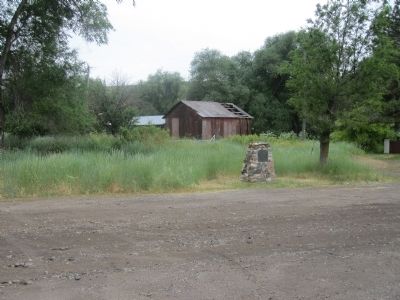
Matt Warner was born Willard E. Christiansen in Ephraim, Utah. He left home at the age of 14 after a fight in which he thought he killed the town bully. He took the name Matt Warner, became a cattle rustler, bank robber and rode with Butch Cassidy . . . — — Map (db m101029) HM
On North Main Street, on the right when traveling south.
Bountiful City
Incorporated December 14, 1892
Perrigrine Sessions drove his wagon north to this area in September of 1847. Here Sessions Settlement had its beginning, the second settlement in the territory of Utah. In 1855, . . . — — Map (db m245966) HM
On Orchard Drive at Mill Street, on the right when traveling north on Orchard Drive.
Heber C. Kimball was born on June 14, 1801 to Solomon Farnham Kimball and Anna Spaulding Kimball in Sheldon, Franklin County, Vermont. He married Vilate Murray on November 7, 1822.
Kimball was converted to The Church of Jesus Christ of . . . — — Map (db m127584) HM
Explorers John C. Fremont and Kit Carson observed several antelope on the island during their 1845 journey, thus giving Antelope Island its name. This was the beginning of the island's recorded history.
An Island of Interest
Herdsman, . . . — — Map (db m243429) HM
Farmers used bailers in both
hay and grain production.
Hay and straw had to be
hauled to and hand-fed into
the baler for processing. This
process could be dangerous
to operators because their
hands and arms could be
sucked into the . . . — — Map (db m171430) HM
For over half a century, workers harvested grain by hand. This was a very
time consuming process.
By 1900, Island farmers had adopted mechanized grain binders to cut, bundle
and tie grain stalks together into sheaves. Farm hands loaded . . . — — Map (db m171434) HM
The Fielding Garr Ranch was first settled in
1848 and represents 133 years of western ranching
history. While exploring the ranch you will learn
of its colorful past and discover that many periods
of history are represented here. Evidence . . . — — Map (db m171405) HM
Near Antelope Island Road, on the right when traveling north.
Residents used horse-drawn
wagons on the island
from 1848 through the
1960s due to the prohibitive
cost of hauling fuel to
Antelope Island.
Horse and wagon were used
year-round to haul supplies
anywhere they were needed.
In the . . . — — Map (db m171427) HM
Employees of the Island
Improvement Company
planted several hundred
acres of hay and 1000
acres of wheat each year
on the Island.
Workers disked new fields
to remove surface weeds
and broke up deeply
compacted soil by using
the . . . — — Map (db m171450) HM
During the 1840s-1850s,
workers harvested grass
hay by hand and loaded it
onto wagons to be stored
for winter feed.
By 1870, field hands
switched to sickle mowers,
like these displayed here,
to harvest their hay. Initially
drawn by . . . — — Map (db m171436) HM
The Fielding Garr Ranch operated from 1848 to 1981.
As you walk through the site, see how many different types of building
materials you can identify.
Ranchers used the natural resources of the Isiand for their construction
projects. . . . — — Map (db m171508) HM
After 1900, farming
activities increased on
the Island.
Tractors became the most
important piece of
equipment at the ranch.
The first tractor you see is
a 1929 Case Model L.
This tractor pulled plows,
powered belt-driven . . . — — Map (db m171451) HM
Transportation to Antelope
Island varied due to
fluctuating lake levels.
In the late 1840s, residents
and visitors came to the
Island by horse and wagon
on buckboards like this one.
By 1853, lake levels rose
enough to make boats . . . — — Map (db m171507) HM
Eventually trucks replaced
wagons as a more efficient
and cost-effective mode
of transportation and
movement of supplies.
During low water years a
sandbar was exposed on the
Southeast end of the Island.
Trucks could cross . . . — — Map (db m171463) HM
Among those who homesteaded Antelope Island were George Issac Frary, his wife Alice Eliza Phillips Frary, and five of their seven children Guy, Grace, Lottie, Dora and Frank. This spot is where the family lived, worked and played from 1891 to . . . — — Map (db m172304) HM
On State Highway 31, on the left when traveling south.
In 1875 Leander Lemmon and James McHadden seeking a good range for their horses, found feed plentiful at the mouth of Huntington Canyon and vicinity. Mr. Lemmon brought sheep and cattle from Cottonwood, Salt Lake County. In the autumn of 1876,he . . . — — Map (db m240517) HM
On North Main Street (Utah Route 130) south of Iron Mission Parkway (West 685 North), on the right when traveling south.
Iron County exists because those who lived here developed the resources necessary for survival in this desert climate. The three legacies passed down by early settlers and their descendants — agriculture, mining, and railroads — are . . . — — Map (db m130593) HM
On North Main Street (Utah Route 130) south of Iron Mission Parkway (West 685 North), on the right when traveling south.
Hay for livestock in a horse-driven society was as important as gasoline or electricity is today. The oldest technology for stacking hay in Iron County was the hay derrick that allowed farmers to build haystacks in their fields.
Hay derricks, . . . — — Map (db m130599) HM
On Jones Road, 0.1 miles west of Enoch Road, on the left when traveling west.
Schoolhouse - The second schoolhouse in Enoch was a two-story structure built on this site in 1917-1918. It was a brick building containing two classrooms, two libraries, two bathrooms and a furnace room. Only one room served as a classroom, and . . . — — Map (db m59568) HM
These millstones were used to grind wheat and corn into flour. Glendale oral histories tell us that in 1870 these burrs, as they were called, were brought here from Toquerville, Utah, 100 miles away.
Histories written about this area report that . . . — — Map (db m40475) HM
On State Street (U.S. 89) at the road to Mount Carmel Cemetery, on the left when traveling north on State Street.
In memory of Isaac Behunin,
Mormon Pioneer, Early Utah Settler and
Credited with the naming of Zion Canyon
Early Mormon Pioneer
Isaac Behunin was born October 20, 1803 in Richland, New York to Albert and Nancy Lord Bohanan (Bohannon). . . . — — Map (db m40465) HM
In 1865 Peter Shirts made the first settlement in this area. Other pioneers followed but were forced to vacate because of Indian raids. The town was resettled upstream in 1870; church and school buildings were erected under the direction of William . . . — — Map (db m40379) HM
The Wardle farm began as an 80-acre parcel which was originally worked by Isaac John Wardle Jr., who leased the property from W. Henry Wallace of Salt Lake City.
Johnny Wardle began farming the property in the early 1900s growing alfalfa and . . . — — Map (db m231214) HM
Near Big Cottonwood Canyon Road, on the right when traveling south.
During their first 20-plus years in the Salt Lake Valley, people who settled this area did so at the mouth of Big Cottonwood Canyon. They depended on the sawmills and later the mines as a means of support. Following the joining of the . . . — — Map (db m123647) HM
On Pioneer Road near South 1130 East, on the right when traveling west.
Cooperation between Utah State University in Logan and the Utah Poultry Producers led to development of a special breed of chicken, the White Leghorn, to produce a pure white egg that soon became preferred by consumers over the brown eggs of other . . . — — Map (db m224597) HM
During World War II, the U.S. Government purchased eggs, chickens and turkeys from the Utah Poultry Producers to be shipped to troops overseas.
At the cooperative's 1942 annual meeting, Utah Poultry Producers President, Clyde C. Edmonds . . . — — Map (db m224568) HM
Near Pioneer Road west of South 1130 East, on the right when traveling west.
Local Farms Produce National Results.
By the Great Depression, more than 5,000 families across Utah had chicken coops and relied on egg checks from The Utah Poultry Producers Cooperative Association to help with cash flow during hard economic . . . — — Map (db m224574) HM
On Pioneer Road near South 1130 East, on the right when traveling west.
By many standards, Utah land is not well suited to agriculture - Nature has been stingy in that regard. Good crop land is scarce. Water is not plentiful, nor can it even be found in many places. Yet, driven by a sense of gathering and a yearning for . . . — — Map (db m224594) HM
On Pioneer Road west of South 1130 East, on the right when traveling west.
The cooperative success of Utah poultry farmers changed the way we eat today. Before this effort, eggs were not reliably fresh and were not eaten year-round until the "Milk White" marketing plan shattered stereotypes and won connoisseurs.
Every . . . — — Map (db m224600) HM
On Pioneer Road west of South 1130 East, on the right when traveling west.
Intermountain Farmers Association (IFA)
What started as a marketing cooperative for eggs in 1923 has evolved over the years to serve the varied needs of farmers and ranchers throughout Utah and neighboring states.
After almost a century, . . . — — Map (db m224595) HM
Near South 1500 West, on the right when traveling north.
In 1886, the Riverton Branch of the Church of Jesus Christ of Latter-day Saints purchased choice land for a tithing yard from Samuel L. Howard Sr., located between 12400 and 12600 South, one mile northeast of this park. Members brought one tenth of . . . — — Map (db m34681) HM
Parley's Creek, originally known by the Indian name Obit-Ko-Ke-Che Creek, was the largest stream of water which flowed from the Wasatch Mountains into the valley. This creek had beginnings high in the Wasatch Mountains to the north near what became . . . — — Map (db m123769) HM
The gardens surrounding the Deuel family log cabin represent the native vegetation the Latter-day Saint pioneers found and the landscape they created during their early years in the Salt Lake Valley. For protection from wind and sun, they planted . . . — — Map (db m245951) HM
Commemorating the beginning in America of Modern Irrigation in this vicinity on July 23 and 24, 1847, by the “Mormon” pioneers.
————————————— . . . — — Map (db m1376) HM
On University Boulevard at State Street, on the right when traveling east on University Boulevard.
This ten-acre block served as camping grounds for immigrant trains.
The vanguard of the first band of pioneers pitched their tent here July 23,
1847, at which time their leader Orson Pratt dedicated the land. Later it became
the focal point for . . . — — Map (db m143213) HM
On State Street at South Temple Street, on the right when traveling north on State Street.
The Eagle Gate marked the entrance to the homes of Brigham Young. During the early settlement of the valley, Brigham Young was aloted the land lying athwart the mouth of City Creek Canyon. His New England heritage prompted him to desire the privacy . . . — — Map (db m35161) HM
On Herbert Avenue, on the right when traveling west.
In 1867 Paul A. Schettler, an ardent supporter of the silk industry in Utah, acquired this land and planted five acres in mulberry trees, the leaves of which were used to feed silk worms. He built two cocooneries near this location. Elizabeth Von . . . — — Map (db m176751) HM
Near South 1300 West south of South Jordan Parkway (Utah Route 151).
Constructed in 1898, the Garside/McMullin House reflects the restrained Queen Anne style that was common in rural Utah during the late nineteenth century. Architectural components such as turrets, projecting bays, balcony, porches, and corbelled . . . — — Map (db m222700) HM
The granary had a unique use and function on the farm and therefore had a unique design. The structural framing members are on the outside of the barn and are heavy to withstand the weight of the grain. The sheating or planks of the barn were on the . . . — — Map (db m230376) HM
On Holt Farm Lane east of South Temple Drive, on the left when traveling east.
Harkening back to the days of the wild-west, cowboys and cowgirls would temporarily tie up their horses to wooden hitching posts. They had to be sturdy so the horses could not pull away. A hitching post is a vertical column with one or more rings . . . — — Map (db m230379) HM
Family members of all ages took part in the sheep shearing each year. After the older ones sheared the wool from the sheep, the children's job was to fill long cloth bags with handfuls of the thick fibers. The bags were 8 to 10 feet long. The . . . — — Map (db m230377) HM
Every day, fresh milk from the Holt farm was stored in large metal cans, which stood in the cement vat inside this building. Outside the west wall of the milk house was an underground well and pump, which was used to pump cold water though a small . . . — — Map (db m230380) HM
The Samuel Elijah Holt Farm, with its buildings dating from 1907 to c. 1930, is one of the last surviving examples of an active homestead built by early settlers of South Jordan. Mr. Holt, born August 30, 1868, purchased this farm from his father, . . . — — Map (db m230411) HM
Samuel Elijah Holt was born on August 30, 1868, five years after his family arrived from England. The family lived in a one-room log cabin on the bank of the Beckstead Ditch (east of the South Jordan cemetery). Samuel's childhood days were spent . . . — — Map (db m230381) HM
In the 1870s with the coming of the new irrigation canal, Matthew Holt, Samuel E. Holt's father, gave permission to have the canal run through the west end of his property. This allowed him easy access to two water weirs off the canal for . . . — — Map (db m230378) HM
On Holt Farm Lane east of South Temple Drive, on the left when traveling east.
The Samuel Elijah Holt Farm, with its buildings dating from 1907 to c. 1930, is one of the last surviving examples of an active homestead built by early settlers of South Jordan. Samuel Elijah Holt, born August 30, 1868, purchased this farm from his . . . — — Map (db m230374) HM
Near Carlisle Park Lane, on the right when traveling south.
In the 1850’s and 1860’s, three brothers, Joseph, John, and Richard Carlisle, settled in this location between 700 West and Jordan River. Their endeavors included farming, dairying, and planting mulberry trees to raise silk worms. They developed a . . . — — Map (db m124303) HM
In 1855, upon the counsel of Brigham Young, Joseph Harker, with John and Samuel Bennion, hand-dug the lower ditch to irrigate the farmland on the river bottoms west of the Jordan River.
A small rock dam was constructed on the Jordan River at . . . — — Map (db m123573) HM
On 1825 West, 0.1 miles south of 7800 South (Utah Highway 48), on the right when traveling south.
In 1849 Governor Brigham Young sent Apostle John Taylor on a mission to France to investigate industries that could be successfully established in the New Mountain Empire. There he met Philip De Lamare, a man of exceptional talents and substantial . . . — — Map (db m35548) HM
The settlement of the valley west of Salt Lake City was linked to the availability of water. The first settlers to the area came in the fall of 1848. Joseph Harker built a dugout in bluffs along the west bank of the Jordan River at about 3300 South. . . . — — Map (db m222707) HM
Near South Main Street south of West 100 South, on the right when traveling south.
The first white settlers of the region were cattlemen. Cattle were first introduced into the San Juan County-Blue Mountain area during the 1870s. Large numbers of the animals were placed on the thousands of acres of lush grasses which grew in the . . . — — Map (db m95129) HM
In the 1840s settlers in the west were typically separated by miles of open fields, leaving individuals and families isolated and unprotected. The pioneers, however, did not follow this settlement pattern when they gathered together in Utah. . . . — — Map (db m243332) HM
On Utah Route 196 at milepost 23,, 15 miles south of Interstate 80, on the left when traveling south.
This hallowed place was dedicated on August 28, 1890 by President Wilford Woodruff for all the nations in the isles of the seas, the Polynesian pioneers, their descendants and the faithful Church leaders who left their home in the mid 1800’s and . . . — — Map (db m1259) HM
On West Main Street (U.S. 40) at South Vernal Avenue (U.S. 191), on the right when traveling east on West Main Street.
Diagonally across the street is the First Security Bank building. When it first opened on August 10, 1910, it was called the Uintah State Bank.
The local Mormon population did not like the loan policies of the Catholic-managed Bank of Vernal, . . . — — Map (db m114433) HM
Built in the 1870's for the Alpine Ward Relief Society of the Church of Jesus Christ of Latter-Day Saints. The sisters used it to store grain for the use by families who were in need. Originally was near the tithing barn on about 50 East and Center . . . — — Map (db m224311) HM
On Mill Pond Road at Pioneer Crossing, on the right when traveling south on Mill Pond Road.
The Lehi factory of the Utah Sugar Company, of the Church of Jesus Christ of Latter-day Saints, occupies a pre-eminent place among early sugar mills in America. As historian Leonard Arrington has written: “It was the first sugar-beet factory . . . — — Map (db m149976) HM
On North 800 East at East 950 North, on the left when traveling north on North 800 East.
In December 1943, Governor Herbert B. Maw dedicated a five acre site at this location for the use of the war department during the latter part of World War II. The first occupants of the camp which was built here were approximately 200 . . . — — Map (db m184070) HM WM
On 650 North at Orem Boulevard, on the right when traveling west on 650 North.
The first major industry to locate in Orem was the Pleasant Grove Canning Company. The plant was built at 325 West 700 North (currently Orem Boulevard in 1919 which provided close proximity to the railroad that was located along Orem Boulevard. The . . . — — Map (db m240705) HM
On South 100 East, on the right when traveling north.
Built c1874 at 200 W. 100 N. over what is thought to be their original rock-lined dugout. This granary is representative of many granaries built by all Pleasant Grove farmers for grain storage. Root vegetables and apples were stored in cellars, some . . . — — Map (db m149576) HM
On South 100 East, on the right when traveling north.
In 1872 Archibald Gardner built the first flour mill in Pleasant Grove which he sold, in 1876, to David Adamson who installed these grinding stones. They were run by waterwheel also a steam engine when water was low. Grain was ground into fine flour . . . — — Map (db m149578) HM
This plow was donated to the museum by Mr. and Mrs. Leslie E. Nelson, of Hurricane,
Utah.
History of the plow is from Mr. Nelson’s grandmother, Hulda Ellertson Kay, who was housekeeper for Apostle Hyde during the period of 1875.
The Nelson . . . — — Map (db m59403) HM
On East 200 North, 0.1 miles east of North State Street, in the median.
A bowery was built near here in August 1904 for the celebration of the long-awaited arrival of water to the Hurricane Bench and to name this new town. After twelve years of back-breaking work, the Virgin River water, carried seven miles from the . . . — — Map (db m59430) HM
Smith Mesa, northeast of Hurricane and nearly one-half mile higher in elevation, was named after Charles Nephi Smith, Bishop of Rockville from 1867 to 1891. He had a ranch house on Smith Creek and ran his cattle on this beautiful mesa.
Shortly . . . — — Map (db m59404) HM
The warm comfortable productive climate in the sheltered valleys along the meandering Rio Virgin and its lower tributaries in Washington County became known as "Utah's Dixie".
The rugged pioneer colonizers and their descendants are known as . . . — — Map (db m59365) HM
On West 500 North, on the right when traveling east.
In December of 1888, Thomas P. Cottam and Thomas Judd made a preliminary survey to determine the probable cost of a canal. Early in 1889, Isaac C. MacFarlane made a working survey, and work was started as soon as his survey was completed.
In June . . . — — Map (db m59451) HM
On North Main Street (Utah Route 228), on the right when traveling north.
The building to your left was originally built as a schoolhouse in 1880 in nearby Silver Reef. It also served in the mining boomtown as a place for community dances and other gatherings.
Soon after the schoolhouse was built, Silver Reef began . . . — — Map (db m59663) HM
On Center Street at Main Street, on the right when traveling south on Center Street.
This building, built in 1891-92, was the Leeds Tithing Office. The building was most likely constructed by the renowned stone masons of the era, Willard McMullin and Sons.
The settlers of Leeds were almost exclusively members of The Church . . . — — Map (db m243203) HM
On North Main Street at West Center Street, on the left when traveling east on North Main Street.
From Ditches to Pipes
The Use and Control of Water Controls the Future
The earliest settlers in Leeds used innovation and hard work to divert water from Leeds Creek to their homes, fields, and industry. The town pioneers carefully . . . — — Map (db m243206) HM
Water—the lack of it and too much of it—was the greatest challenge to Dixie’s early Mormon settlers. When the original company of families entered the St. George valley late in 1861, they had little more than two small springs to reply . . . — — Map (db m1395) HM
Built just five years after St. George was settled, the Gardeners’ Club Hall is considered to be the oldest public building standing in the city. This small, unassuming adobe building predates the courthouse, the Tabernacle and the Temple by several . . . — — Map (db m1385) HM
On East 200 North, on the right when traveling west.
The Utah-Idaho Sugar Company after determining that sugar beet seed was a good cash crop, bought these grounds and started production that would last for nearly fifty years.
Sugar beets were planted in the fall in the Bloomington and Washington . . . — — Map (db m59221) HM
One of the most difficult challenges in the settlement of Bloomington, Price City and Atkinville in the late 1860's was taking water from the Virgin River and using the water to irrigate the various farm crops. After years of trying to find a . . . — — Map (db m240546) HM
Original Inhabitants
Native peoples lived in the Zion area long before the first Euro-Americans came to this canyon. "Southern Paiutes believe they have lived in this area since the time of creation. Because of the abundance of animals, . . . — — Map (db m40425) HM
The early Mormon settlers of Springdale and other Virgin River communities were resourceful and enterprising farmers. Taking advantage of the natural water resources available on the canyon floor, they dug irrigation systems and planted corn, . . . — — Map (db m40424) HM
On Utah Route 24 at milepost 63.8,, 1.6 miles west of North Teasdale Road, on the right when traveling west.
The Nielsen Grist Mill is located at the foot of Thousand Lake Mountain on the edge of scenic country referred to by ancient Indians as "The Land of Sleeping Rainbow." Constructed around 1893 for Hans Peter Nielsen by his son-in-law, Niels Hansen, . . . — — Map (db m142655) HM