Near Carson Pass Scenic Byway (State Highway 88), on the right.
On this spot, which marks the summit of the Kit Carson Pass, stood what was known as the Kit Carson Tree on which the famous scout Kit Carson inscribed his name in 1844 when he guided the then Captain John C. Fremont, head of a government exploring . . . — — Map (db m100568) HM
At this point in August 1849, a group of Odd Fellows nearing their goal, the California gold mines, paused in their struggle up these granite walls, to paint on this and adjacent boulders their names and the three links of the Great Order they so . . . — — Map (db m100569) HM
On Carson Pass Scenic Byway (State Highway 88), on the right when traveling east. Reported missing.
Here the Old Emigrant Road of 1848 swung down across the meadow now covered by Caples Lake (Twin Lakes) and climbed along the ridge at the right to the gap at the head of the valley. From this summit (9,460 feet) it descended to Placerville. This . . . — — Map (db m100570) HM
On Carson Pass Highway (California Route 88) at Mud Flat Road, on the right when traveling east on Carson Pass Highway.
At this place the highway crosses the site of the old emigrant road which here began a long loop around the Silver Lake basin, taking it to an elevation of 9,640 feet at one place. This difficult portion of the road was used by thousands of . . . — — Map (db m175821) HM
On Carson Pass Scenic Byway (State Highway 88), on the right when traveling east.
“…there ought to be a shaft raised to Snow-Shoe Thompson: Not of marble; Not carved and not planted in the valley, but a rough shaft of basalt or of granite, massive and tall, with top ending roughly as if broken short, to represent a life . . . — — Map (db m12028) HM
On State Highway 4/89 at Montgomery Street, on the right when traveling south on State Highway 4/89.
Originally built in 1862 as the Fiske House in Silver Mountain City. It was dismantled, board by board, in 1886 by A.M. Grover and a crew of men. Each board was marked and many of the old square nails were saved. It was re-erected on this site and . . . — — Map (db m20631) HM
Summer after summer the Washoe Indian people visited the valley. Eventually their idyllic retreat was discovered.
During the winter of 1844 Captain John Fremont may have seen this place during his crossing of the Sierra. Fremont’s diary of his . . . — — Map (db m11001) HM
On Ebbetts Pass Scenic Byway (State Highway 4), on the left when traveling east.
Named after Major John Ebbett and pointed out in 1853 to surveyor G.H. Goodard who referred to it as a “route of great promise – probably the best one for a transcontinental railway.”
No emigrant train used this route but a . . . — — Map (db m11444) HM
On December 18, 1872, Ernst Reusch, a jealous husband shot and killed E.H. Erickson through the window of Erickson’s Saloon in Silver Mountain City as Erickson played cards. Reusch believed that Erickson had been having an affair with his wife and . . . — — Map (db m116094) HM
Near Alpine State Highway (California Route 89) south of Water Street, on the left when traveling south.
On September 12, 1861, Jacob Markley staked out a land claim of 160 acres, a parcel that included this site. Markley erected a 16 by 20 foot log cabin somewhere near this plaque, covering it with shakes made from local Sugar Pine. He also built a . . . — — Map (db m157808) HM
On August 2, 1885, fire broke out in the Town of Markleeville destroying several buildings, including Harvey and Rask’s Bucher Shop and Smokehouse. Later on in the Fall, the building was rebuilt and reopened as Rask’s Butcher Shop.
The building . . . — — Map (db m11963) HM
On Diamond Valley Road, 3 miles east of California Highway 89, on the right when traveling west.
This marks the home of John Albert Thompson (Snowshoe Thompson) great pioneer of the Sierras and hero of the mountains, who for twenty winters carried the mail over the deep snow of the mountains on his long skies: Giving help to those in need along . . . — — Map (db m21302) HM
On Diamond Valley Road, 3 miles east of California Highway 89, on the right when traveling west.
John A. “Snowshoe” Thompson (1827-1876) Native of Norway who carried mail across the Sierra Nevada on skis, assisting the needful for twenty years, dwelt and died on this site.
Dedicated on June 30, 1990
Native Sons of the Golden . . . — — Map (db m21301) HM
The Raymond Mining District was in operation from 1863 – 1869. It was located roughly four miles north of Silver Mountain and four miles south-west of Markleeville, along Krumm Creek entering Pleasant Valley. Named for R. W. Raymond, who . . . — — Map (db m116092) HM
On Luther Pass Road (California Route 89) 4 miles north of California Route 88, on the left when traveling north.
"Passed over the summit of the first range and came to [Grass] lake situated nearly on the summit of the mountain....We began our decent [sic] down the mountain over as rough a road as we came up, into Lake Valley" - Luman A. Scott, Sep 8, 1859 — — Map (db m212025) HM
Near Luther Pass Road (California Route 89), on the left when traveling north.
"Then up hill [from Hope Valley] and away, steep and rugged and we at last gain the first summit of the Nevada Mountains [at Luther Pass] and down t'other side more rugged than ever" - John McTurk Gibson, Sep 3 1859... — — Map (db m212003) HM
On Burnside Road, on the right when traveling south.
"We immerged [sic] from the canon [sic] into a pretty valley in between two ranges of high mountains. Pretty pine trees were scattered over a small grass lawn, and a beautiful mountain stream passed through it." - Lorena L. Hayes, Sep . . . — — Map (db m211992) HM
On Burnside Road, on the right when traveling south.
"We crossed Carson River, for here we leave the Carson Route and take what is called the Johnson Route or 'Johnson's Cut-Off to Hangtown'." - J. Robert Brown, Sep 25, 1856 — — Map (db m211987) HM
On Burnside Road south of Carson Pass Highway (California Route 88), on the right when traveling south.
"We crossed Carson River, for here we leave the Carson Route and take what is called the Johnson Route or 'Johnson's Cut-Off to Hangtown'."
- J. Robert Brown, Sep 25, 1856 — — Map (db m212969) HM
On Old Pony Express Way (California Route 88) east of California Route 89, on the left when traveling east.
Historic Woodfords Station, the Eastern Sierra gateway to the goldfields of California, way station of the famed Pony Express, and entrance to Carson Pass on the Emigrant Trail to the Sacramento Valley. Beginning in 1849 with the building of the . . . — — Map (db m195369) HM
The first internment in the Amador City Cemetery was 1851 with the last being in 1892. There are many more graves than indicated by the marble headstones. Some graves were never marked and others utilized hand carved wooden markers. During the . . . — — Map (db m17020) HM
On Fiddletown Road, on the right when traveling east.
Settled by Missourians 1849. Suggested that settlement be called Fiddletown because residents “were always fiddling”. Changed in 1878 to Oleta but original name later restored. Once trading center for American, Loafer, and French Flats, . . . — — Map (db m100577) HM
On Fiddletown Road, on the left when traveling east.
California Historical Landmark
—— Fiddletown-Oleta ——
Settled in 1849 by a party from Missouri. According to tradition they were always fiddling, especially while waiting for the rainy season—hence the name..... It . . . — — Map (db m2539) HM
On Jibboom Street near Ostrom Road, on the left when traveling east.
Hiram C. Farnham built this home for his bride, Eunice Haynes. It overlooked the creek and steam powered sawmill that he built with James McLeod in 1853 to serve the new rich gold strike in Fiddletown. The boomtown was served by six stagecoaches a . . . — — Map (db m41369) HM
On Buena Vista Road at Jackson Valley Road on Buena Vista Road.
Buena Vista's store and house situated in Jackson Valley, was built by John Fitzsimmons, then sold to Sam Cook, then to James Norris and afterwards to Jacob and Verona Strohm. Once situated in Lancha Plana it was moved by the Chinese who discovered . . . — — Map (db m10189) HM
On East Main Street, on the right when traveling west.
General merchandise store built by Daniel Stewart in 1856. First brick building erected in Ione Valley from nearby Muletown brick. Ione, once known as "Bed-Bug" and "Freeze-Out” was an important supply center on the main road to the Mother Lode and . . . — — Map (db m100587) HM
On East Main Street at Eldorado Street, on the right when traveling west on East Main Street.
Looking North from this monument lies 5.22 acres which was originally deeded to Ky Kee, Hop Wah Chung, Quong On Long and Chang Hang Co. in 1883. Known as Chinatown, the community was comprised of stores, homes and a Joss House. At the peak of . . . — — Map (db m42397) HM
In 1848, Mexican Settlers from Sonora, Mexico established a camp on the north back of the Mokelumne River and called it Sonora Bar. At the start of the California Gold Rush miners flocked to the Mokelumne River and set up camps and towns along its . . . — — Map (db m126094) HM
Near Michigan Bar Road (California Route 104) 1.5 miles East Plymouth Highway (California Route 124).
Quincy, located approximately 1 1/2 miles east of here off Mule Creek, was one of the cities within the boundaries of Rancho Arroyo, or the grant, that suddenly appeared in the early 1850's.
Don Andreas Pico purchased the grant from Teodosio . . . — — Map (db m94747) HM
Near Five Mile Drive - Old Stockton Rd. (name changes) near West Marlette St..
Property settled by J. P. Martin in 1848. Home built circa 1852. Purchased in 1882 by William Scully, who arrived from Ireland in 1854. The Scully family has owned and operated the ranch for five generations. Present owners are Robert and Etta . . . — — Map (db m42398) HM
On State Highway 49 (California Route 49), on the right when traveling south.
Erected by the Citizens of
Amador County California in
Memory of
Anthony Caminetti
A native of Jackson,
Amador County
Born July 30 1854
Died November 17 1923
District Attorney, State Senator, United States Congressman, United . . . — — Map (db m72067) HM
On North Main Street, on the right when traveling north.
Very Reverend Archimandrite Sebastian Dabovich
The First Administrator of the Serbian Church In America – Born in San Francisco on June 21, 1863 – Died November 30, 1940 in the Monastery of Zitcha at the Age of Seventy-Seven. — — Map (db m13966) HM
Argonaut Mine, discovered 1850, and Kennedy Mine, discovered 1856, played dramatic roles in the economic development of California. They produced $105,268,760 in gold. Kennedy Mine has a vertical shaft of 5,912 feet, the deepest in the United . . . — — Map (db m100586) HM
In 1848, was a village of huts and tents called
"Bottileas”
by the Mexicans from the bottles strewn about by those who tarried here.
In 1849, it was named
Jackson
for Colonel Jackson an early day resident.
In 1853, Amador . . . — — Map (db m72060) HM
St. Sava Serbian Orthodox Church was erected in 1894. It is the first Serbian Orthodox church built in the U.S. Rev. Sebastian Dabovich, first Priest in this parish. Born in S.F. & reared in nearby Plymouth. Inspired his people in the early 1890’s & . . . — — Map (db m11514) HM
Near Water Street, on the left when traveling west.
This monument marks the site of a spring that refreshed the early travelers into this region. So many bottles were found around this spring that some Chilean miners called the site "Bottileas" or place of the bottles, the first name by which the . . . — — Map (db m21371) HM
Prominent in the mining world through his work at the Zeile, Kennedy, Argonaut & other Mother Lode mines, 1881 – 1929. His public spirit and mechanical skills led to many improvements in Jackson’s streets and bridges.
First Mayor of . . . — — Map (db m27978) HM
On Center Street near State Highway 88, on the right when traveling north.
The William J. Paugh House, also known as Rosewall, is a very pure example of a Gothic Revival House. The style was most popular during the 1840's and 1850's. It was built in the late 1850's by Charles L. Parish, artist, architect and builder. . . . — — Map (db m28067) HM
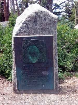
On Carson Pass Scenic Byway (State Highway 88), on the right when traveling east.
Broken dreams and hope, carried 2000 miles through scorching deserts and over loft mountains. At last...the sight of the promise land. Those of you who visit this grave carry a torch of love and hope (which this young girl lost), and pass it on, to . . . — — Map (db m100573) HM
On Plasse Road near Carson Pass Scenic Byway (California Highway 88).
Raymond Peter Plasse arrived 1850 in San Francisco. Mined gold at Volcano & Aqueduct. In 1853 started a trading post (now site) on Emigrant Road near Wester’s Gap. & a log cabin (now used at Silver Lake. Traded supplies & fresh livestock with . . . — — Map (db m21249) HM
On Clinton Road at Ponderosa Road / East Clinton Road, on the left when traveling south on Clinton Road.
Prospectors in 1849 traveled from the Mokelumne River through Clinton on the way to the diggins in Volcano. In the early 1850’s the camp of Clinton became a market town, supplying the placer miners of the middle and southern forks of Jackson Creek, . . . — — Map (db m100578) HM
On State Highway 88 east of Irishtown Road, on the right when traveling east.
Late 1854, in a grove of tall pines Albert Leonard built his Pine Grove Home & Inn & was first postmaster. It was located at the junction of stage roads to Jackson and Clinton.
Pine Grove post office was established July 12, 1856. First school . . . — — Map (db m10505) HM
On Amador/Nevada Highway (State Highway 88) 0.6 miles Panther Creek Road, on the right when traveling east.
Established as Foster’s Trading Post in 1855, this building was constructed in 1862 when this area was known as Spring Valley. It later became Smith’s Hotel which boasted a “carpeted parlor for the ladies.” The building and the 640-acre homestead . . . — — Map (db m175870) HM
Was a mining camp about 1852. Plymouth proper began with quartz mining when settled early by Green Aden & other hard rock miners. Town was named Plymouth, probably after nearby Plymouth Mine. Post Office established 1871. Many town fires, most . . . — — Map (db m41349) HM
On Jackson Road (State Highway 16) 0.2 miles west of Forest Home Road, on the left when traveling east.
Copper mines patented 1873:
Peak Outputs: Early 1860’s, 1895-1917, 1943-1947,
Township organized 1854.
A Methodist center for many years
U.S. Postoffice: 1862-1905 — — Map (db m11361) HM
On Plymouth Shenandoah Road at Shenandoah School Road, on the left when traveling east on Plymouth Shenandoah Road.
Dedicated to the early Shenandoah Valley pioneers & their descendants. They mined gold & produced grain, livestock, orchards & vineyards in these rolling hills. Nearby are the old school, used for 100 years, and now a social center, and the cemetery . . . — — Map (db m10639) HM
On Mormon Emigrant Trail (NF-5), 1 mile west of 88 (California Route 88), on the right when traveling west.
Stop(p)ed & camped Leek Springs. A beautiful little valley surrounded by a large pine and fur trees. The most romantic spot we have camped upon. Mendall Jewett, July 19, 1850. — — Map (db m227886) HM
On Sutter Hill Road at Eureka Road, on the right when traveling west on Sutter Hill Road.
Amador County, carved from Calaveras and El Dorado, was organized July 3, 1854, at the crossroads of Sutter Hill.
Act of Legislature, May 11, 1854, set June 17, 1854, as election date for people to vote on such a division, and appointed five . . . — — Map (db m11222) HM
Eastern Shaft of the Wildman Mine located at the Post Office site. Used as an air chute and hoist shaft to dispose of waste rock later used to pave roads. The mine founded by William T. Wildman, circa 1851 — — Map (db m12601) HM
On Gopher Flat Road, on the left when traveling east on Gopher Flat Road.
A man of tremendous ambition, Leland Stanford, Sr., was one of California’s most distinguished businessmen, politicians, philanthropists, and proponents of education. Lured to California by the Gold Rush in 1852, he became an owner of Sutter Creek’s . . . — — Map (db m12610) HM
Founded by Jerry Mahoney from Killarney, Ireland in 1851. Claim purchased from Alvinza Hayward. Merged with the Wildman Mine and reached a depth of 1200 feet. Produced $5 million in gold. Later part of Lincoln Consolidated Co. — — Map (db m12606) HM
On Old Route 49 (Main Street), on the left when traveling south.
Sutter Creek, California
Left Panel:
Like many communities in the Sierra Foothills, Sutter Creek grew out of the great gold rush of 1849. Thousands of men of every nationality arrived seeking fortunes through toil, sweat, and luck. . . . — — Map (db m106380) HM
On Church Street, on the left when traveling east.
One of Sutter Creek’s legends is that John Sutter founded this city in 1846 when he established a sawmill on the creek. But modern researchers have discovered he actually sent men into the Sierra foothills at least by 1844 to a place about four or . . . — — Map (db m176322) HM
On Main Street (Old Highway 49) at Fiefield Street, on the left when traveling north on Main Street (Old Highway 49).
Associate of Leland Stanford, Pioneer, Miner, Legislator, Businessman. Sailed around Cape Horn on clipper ship Tahamaroo in 1849. Established the first deep quartz mine, The Union, with E.B. McIntyre, S. Hanford & N. Drew in 1851. Became . . . — — Map (db m29829) HM
On Main Street (Old California Route 49), on the right when traveling north.
On September 4, 1854 Sutter Creek was declared by Judge Marion Gordon an incorporated town. Sutter Creek's limits were one mile square. The center was "The Liberty Flag Pole", atop Main Street (Little Humbug Hill) where the Native Sons Hall stands . . . — — Map (db m94113) HM
On Main Street (Old Highway 49) near Church Street, on the right when traveling north.
In 1861 under leadership of Rev. I.B. Fish this church was built . Trustees incorporated the church as the Methodist Episcopal Church in 1862. Between 1863 and 1867 the Ladies Aid Society gave $1,300 for the back room addition. The steeple was added . . . — — Map (db m13684) HM
Founded by William T. Wildman in 1851. Merged with Mahoney Mine and reached a depth of 1500 feet. Combined mines operated a 70 stamp mill and produced a total of $5 million in old by 1924. Powder house used to store explosives. Became part of . . . — — Map (db m12598) HM
This plaque is in memory of the pioneers of California who assembled in Volcano where Moose Milk was originated.
Dedicated this 13th day of January, 1951 by E Clampus Vitus.
[A rededication marker, just below the main one, . . . — — Map (db m9055) HM
On Main Street at Consolation Street, on the left when traveling north on Main Street.
This plaque is in commemoration of two soldiers of a party from Stevenson’s New York Regiment who discovered Volcano Valley in late 1848 and camped here in Soldier Gulch through a hard winter. Their bodies were discovered in the spring and buried . . . — — Map (db m11364) HM
On Main Street at Consolation Street, on the left when traveling north on Main Street.
Discovered in 1848 by Colonel Stevenson’s men who mined Soldiers’ Gulch in ’49. First covered wagon party sluiced rich gravel beds. By ’53, men swarmed flats and gulches naming them picturesquely. Hydraulic operations, begun in ’55, brought . . . — — Map (db m11365) HM
On Main Street at Consolation Street, on the right when traveling north on Main Street.
[Larger Marker]:
Started 1848 by soldiers of Colonel Stevenson’s Regiment. Named by miners because of apparent volcanic appearance. Here the first California rental library, 1850, was established. And one of the first “Little . . . — — Map (db m100574) HM
John Bidwell was born on the east coast to a poor farming family in 1819. In spite of these modest roots, he would eventually become a key figure in California history, one famous for being a true pioneer, a statesman, politician, prohibitionist, . . . — — Map (db m29637) HM
On Yankee Hill Road, on the right when traveling north.
This is the area of the original historic site of Old Yankee Hill. It was first founded as a gold mining town, having in later years a hotel, general store, Wells Fargo post office, saloon and a winery.
Yankee Hill was purchased by the Smiths in . . . — — Map (db m116614) HM
Born in Bucks County Pennsylvania, Neal a blacksmith by trade came to California with John Fremont’s second expedition in 1844. After working for John Sutter briefly at New Helvetia, obtained a land grant and established Rancho Esquon. After . . . — — Map (db m61826) HM
Named for George Lovelock, born in Wales in 1824, emigrated to California in 1850. George Lovelock settled in Butte County in 1851 and began a successful business in Butte Creek Canyon before moving not far from this present site to establish a . . . — — Map (db m61685) HM
Erected by Argonaut Parlor No. 8 Native Sons of the Golden West and Butte County Board of Supervisors, to designate the site of the second county seat of Butte County - Bidwell's Bar 1853 – 1856.
Site of the Court House was 120 yds. west of this . . . — — Map (db m100598) HM
On Foothill Boulevard near Oro-Bangor Highway/Foothill Boulevard, on the left when traveling north.
In memory of
James D. Braselton
his wife
Anna C. Braselton
and their family
The erection of this historical monument
marking the site of their home here at
Garden Ranch built in 1887 and the
Braselton Room in the Oroville . . . — — Map (db m69789) HM
On Cherokee Road, 1.5 miles east of North General Sherman Way, on the left when traveling north.
Led from Indian Territory by their New England schoolmaster, a band of young Cherokee Argonauts discovered gold here 1850. Town established 1853 when first stores erected by Welsh miners. During heyday of 1875, Cherokee boasted its own theatre, race . . . — — Map (db m234) HM
On Broderick Street, on the right when traveling east.
Dedicated in the spring of 1863, this building served as a temple of worship for 10,000 Chinese then living here. Funds for its erection and furnishings were provided by the Emperor and Empress of China and local Chinese labor built the structure. . . . — — Map (db m100599) HM
On Myers Street (Business California Route 70) at Kitrick Avenue, on the right when traveling south on Myers Street.
To Commemorate completion of 4th Railroad in California – Marysville to Oroville, by California Northern Railroad, later the Southern Pacific Co. 1st passenger train February 9 – 1864. Also marks site of Middletown 1854 – 1856. — — Map (db m190381) HM
Site of Gold Rush settlements Long’s Bar, Adamstown, White Rock, and nearby Banner Mine. Sam Neal discovered gold here in 1848. First Christian and Masonic observances in Butte County held here 1849. First county ferry franchise, 1850. — — Map (db m113876) HM
On Oregon Gulch Road at Oregon City Trail, on the left when traveling south on Oregon Gulch Road.
Entering California over the Applegate and Lassen trails, a party of Oregonians, captained by Peter H. Burnett, arrived here in autumn of 1848 to establish the town of Oregon City. Burnett, little more than a year later, became the first civil . . . — — Map (db m100600) HM
Mining settlement named for
Benjamin Nelson
who discovered gold here in 1850.
Town was on both sides of W. Branch
of N. Fork of Feather River. — — Map (db m113875) HM
On Clark Road at Elliott Road, on the right when traveling north on Clark Road.
On these 4 corners was the Old Town of Paradise, known in the 1860’s as Leonard’s Mill. Just north was the mill, hotel and stage stop. To the N.E. was a turpentine distillery. To the east was the school. The Paradise post office was established and . . . — — Map (db m66140) HM
On Pearson Road near Mallan Lane, on the right when traveling east.
There are four sides to this marker, a plaque on each side. Side 2
1852 – 1886
Eugene F. Kunkle • Durville Bequette • Charles Deleplain • Hinrich Buschmann • John Wake • Benjamin F. Butler • William Leonard • Willaim Dresser • . . . — — Map (db m66139) HM
This peaceful community, gateway to the remote regions of the High Lakes of Butte and Plumas Counties, owes its origin and subsequent development to the entrance of the Diamond Match Company to California. With the purchase of about 40,000 acres of . . . — — Map (db m61764) HM
Near Larkin Road at East Hamilton Road, on the left when traveling south.
Erected by
Argonaut Parlor No. 8
Native Sons of the Golden West
and
Butte County Board of Supervisors
to designate the site of the first
county seat of Butte County.
Hamilton
1851 – 1853
Site of Court House was 600 yds. . . . — — Map (db m95740) HM
Is the site of the longest running continuously operated foundry west of the Mississippi River. All quartz machinery needed for the numerous mines surrounding the Altaville, Angels Camp area was cast here. It was previously known as Altaville . . . — — Map (db m13005) HM
On South Main Street (State Highway 49) near Demarest Street, on the right when traveling south.
This structure was erected in 1852 by B. R. Prince and G. Garibardi for a general merchandise business. Improved in 1857 with living quarters on the second floor, it is still used for living and warehouse purposes. — — Map (db m11047) HM
On South Main Street, on the right when traveling north.
Andrew Brosemer followed his
childhood sweetheart, Elizabeth Huberty,
from Belgium. She came with her family
from Luxembourg to Calaveras County
in 1886 to join her uncle who had
homesteaded a ranch in the 1850’s.
Andrew properly . . . — — Map (db m19326) HM
On Main Street (State Highway 49) at State Highway 4, on the right when traveling south on Main Street.
Founded in 1849 by George Angel, who established a mining camp and trading store 200 feet below this marker. A rich gravel mining area and one of the richest quartz mining sections of the Mother Lode. Production records of over $100 million for . . . — — Map (db m14460) HM
On State Highway 49, 3.7 miles south of State Highway 4, on the left when traveling south.
Gold discovered in creek just below town by James H. Carson in 1848, whose name was given to creek, hill and town. In November, 1854, at Morgan Mine, was found the largest gold nugget in California, weighing 195 pounds troy, worth at that time . . . — — Map (db m6848) HM
In Tribute
To the pioneer craftsman whose skills, ingenuity and determination established permanent communities in the wake of the gold rush, and whose progeny have continued to contribute to the region’s character and spirit, recognition is . . . — — Map (db m58925) HM
On Moran Road at Avery Hotel Road, on the left when traveling east on Moran Road.
Hotel and stagecoach relay station, halfway between Murphys and Big Trees. Settled in the 1850’s by Joseph and Sarah Goodell. Purchased by Peter Avery, then operated by three generations of Averys - Peter and Nancy, George and Henrietta and Morton . . . — — Map (db m10615) HM
The oldest continuously operated hotel in Calaveras County, it was built as a family home in 1851 by Joseph and Sarah Goodell of Maine. The Goodells later relocated to Stockton. In 1853 Peter and Nancy Avery, also of Maine, began operating it as a . . . — — Map (db m20626) HM
[Upper Marker:]
Named Camanche in 1849 after Camanche, Iowa. Once called Limerick. Peak population 1500. Rich mining at nearby Cat Camp, Poverty Bar, and Sand Hill. Mokelumne River water brought in by Lancha Plana and Poverty Bar ditch. . . . — — Map (db m19752) HM
On Calaveritas Road at Costa Road, on the right when traveling east on Calaveritas Road.
Calaveritas, settled in 1849 by Mexicans, was a flourishing mining town complete with stores, saloons, gambling houses, and fandango halls. Joaquin Murieta is reported to have frequently visited its Fandango Halls and gambling houses. Destroyed by . . . — — Map (db m12992) HM
Copper here discovered by W. K. Reed and Thomas McCarty in 1860. Mines utilized during the Civil War and the First and Second World Wars. During Civil War period was the principal copper producing section of the United States. — — Map (db m13002) HM
Copperopolis Armory, built by public subscription in 1866 for 8,000 dollars, was used by the Union Guard for enlisting and training troops. In 1866 it was sold to the Copperopolis Armory Hall Association for 800 dollars in gold and was used for . . . — — Map (db m13003) HM
On Main Street, on the right when traveling north.
(There are five markers and one dedication plaque affixed to the flagpole pedestal.)
History of Copperopolis
Copper (for ore) + opolos (for city)
Originally known as Copper Canyon, Copperopolis was established in 1860 when copper . . . — — Map (db m62356) HM
On Rock Creek Road, 4.2 miles north of California Highway 4.
Josephine Felix arrived from France in 1852, one of the first settlers in Salt Spring Valley. Soon widowed, she established a waystation at the junction of the Angels and Central Ferry Roads. She wed neighbor Alban Hettick and the couple developed a . . . — — Map (db m58929) HM
On O'Byrne Ferry Road (State Highway 49), on the right when traveling south.
In 1852 a chain cable bridge replaced the ferries that once crossed here, to be supplanted in its turn by a covered truss structure in 1862. Some writers claimed this was the locale of Bret Harte's Poker Flat. In late “49” there was a large camp . . . — — Map (db m13013) HM
Pioneer Settler & Rancher of Calaveras Co.
Discoverer of copper ore at Copperopolis, Calif. In 1860. Developed mine & was principal share owner, Town was named for the Copper ore. It was a boom town during the Civil War. Copper was used in . . . — — Map (db m19766) HM
2585 entries matched your criteria. Entries 101 through 200 are listed above. ⊲ Previous 100 — Next 100 ⊳