Frog Level and Rodessa
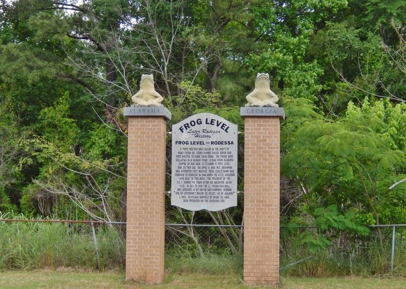
A town meeting was called in the 1800’s by Noah Tyson Sr., store owner, police juror and post master, to name their town. The frogs were hollering in a nearby pond. A man from Alabama jumped up and said, “Let’s name . . . — — Map (db m128259) HM
Typical of the large river plantation of the mid-nineteenth century, the 1,647 acres were located on both the Caddo and Bossier sides of the Red River. Beginning in 1839, Cash Point Plantation was successively owned by several large land owners of . . . — — Map (db m175958) HM
The largest ceremonial center of the Caddo Indians in Louisiana, this site originally included seven mounds arranged around a large plaza. The Caddo Indians lived at this site between 900 and 1200 A.D. — — Map (db m175851) HM
One of the many properties acquired by James Belton Pickett in the period following the succession of the Caddo Indian lands to the United States, c. 1837. Pickett, of South Carolina, came to this area c. 1836. He became one of the founders of . . . — — Map (db m175853) HM
Built as Broadmoor School in 1929. Renamed in memory of Albert Coldwell Steere (1879-1930), influential businessman, philanthropist and real estate developer, and creator of Broadmoor area. Expanded 1938. Listed in National Register of Historic . . . — — Map (db m143801) HM
Now called "Medjoy". Built 1929 as Dodd College President's Residence. Dodd College, named for its founder Dr. M.E. Dodd, operated 1926-1942. This house was Dr. Dodd's residence for many years, Listed in the National Register of Historic Places, . . . — — Map (db m143799) HM
Built 1921 by lumber and railroad executive Randle T. Moore. Moore was also chairman of the board of Commercial National Bank of Shreveport in the 1920's and a trustee and major benefactor of Centenary College. House designed by Shreveport . . . — — Map (db m143714) HM
Possibly named for John Grange Green, pioneer Shreveport property owner and friend of Capt. Shreve, or for Dr. William Mercer Green, who was killed in a duel in this alley, just north of Texas Street, in 1849. South of Texas St. the alley is called . . . — — Map (db m109743) HM
Built circa 1859 as a farm house. Probably Highland's oldest surviving house. Originally located at the present site of Creswell School. — — Map (db m143537) HM
House built 1908 by Lt. Governor Thomas Charles Barett on property purchased by his father in 1866. Acquired by Mr. & Mrs. William M. Barett in 1938. — — Map (db m143030) HM
Built 1912 for planter Abel Bliss and wife Nettie Later home to the Hoyer family. Ewald Max Hoyer was first Mayor of Bossier City (1907) but resided in Shreveport afterward. Hugo Hoyer established Centuries Memorial Park. The house was later the . . . — — Map (db m138825) HM
Two blocks east is site of Coates Bluff settlement and homes of early area settlers Larkin Edwards, c.1803, James Coates, c.1817, and John McLeod, c.1835. The first local post office was located here in April, 1838. — — Map (db m105311) HM
Built 1900 by grandfather of Governor John McKeithen. Purchased from the McKeithen family by Dr. & Mrs. W.M. Adams. The Adams' daughter, Alverne, married Governor Jimmie Davis here. — — Map (db m142363) HM
Built 1910 by lumberman Charles Hawthorne. Girlhood home of his daughter Beatrice Hawthorne Moore (1898-1990), first woman ever elected to the State House of Representatives (1940) and second woman ever elected to the Legislature. Also first woman . . . — — Map (db m143016) HM
Built circa 1870 for Thomas T. and Mary Dilliningham Land. Thomas Land was a state supreme court justice and the family was prominent late 19th to 20th century. Later owned by the Peyton Family who operated a chain of drugstores. The house remains . . . — — Map (db m143021) HM
Built 1899 by John A. Sewall, Jr., grandson of Gen. Charles Albert Sewall, Army engineer who helped Shreve clear Red River log jam. Sewall's brother, John O. Sewall, was Shreveport's first mayor. — — Map (db m141304) HM
Designed as his own residence by John Y. Snyder in 1902. Snyder was a prominent area architect and a geologist of national importance. This house, which once had a wide front porch, is the last remaining residence on Fairfield north of Olive. — — Map (db m143008) HM
Built circa 1856 by Aaron B. Levisee for wife Persia Willis. Named for her family home in Alabama. Surrounding estate was subdivided in 1874 giving name to neighborhood and street. Later home to Foster and Harvey families. Builder Levisee was a . . . — — Map (db m138821) HM
Opened 1882 as city's Catholic Cemetery. Several priests who died in 1873 yellow fever epidemic rest here, including Father Jean Pierre, founding pastor of Holy Trinity Church. Also many pioneer members of Shreveport's French and Italian Societies . . . — — Map (db m143742) HM
Opened in 1883. City's first Black Cemetery established by and for Black citizens. Many prominent early African-American Shreveporters are buried here, From 1868 to 1874 this site was the campus of Shreveport University, a Baptist College. Entrance . . . — — Map (db m143748) HM
Established April 8, 1840 with the burial of Margaret Bilbo.
Burial site of John Jacob Ryan Jr. 1816-1899 Father of Lake Charles.
Earlier site of ancient Attakapa Indian village
U.S. Army Military post, Cantonment Atkinson, 1829-1832
. . . — — Map (db m147002) HM
Panel 1 Born March 23, 1815 in Wyk Auf Föhr, Nordfriesland, now Germany
Immigrated to Philadelphia in 1835 and soon moved to New Orleans
Married Katarina Barbara Moeling March 26, 1846 Moved to Lake Charles in 1855 Died May 19, 1898 in . . . — — Map (db m147253) HM
In 1903, Mesard LaGrange donated an acre for a one-room schoolhouse at this site, and in 1913 offered to donate 9 more acres for an expansion of the school. The School Board at the time offered him $1000 for the land to obtain clear title. In 1929, . . . — — Map (db m116338) HM
Area congregations constructed a two-story orphanage in 1899 that housed up to 150 children at a time. This location was selected for the wholesome, rural character of the setting. The landmark structure was so identified with this part of the . . . — — Map (db m116272) HM
The Henning Family arrived in Calcasieu Parish in approximately 1875 and began to lay the foundation for a remarkable tenure as community, business and industry leaders. Reverend John Henning and Family, including son John Thomas Henning, arrived in . . . — — Map (db m109527) HM
• At this site a natural river crossing was used by Native American who traversed the Ouachita River valley before the time of Christ
(Indian mounds upriver at Watson Brake date 3500 BC.)
• The Ouachita tribe of the Caddo nation was prominent in . . . — — Map (db m244308) HM
In memory of Henry Seth Bennett, born 1842,
died 1924 and Sarah Baggett Cotton, born 1848
died 1922. Henry was a veteran of the Civil War
was shot through the right lung in the Battle of
Chickamauga, Georgia. Was also with General
Lee when he . . . — — Map (db m196753) HM
The Peck Mounds site has 5 mounds built along the bluff above Lake Louie. Only 4 mounds are visible today. The largest is platform shaped and measures 18 feet tall and 165 by 180 feet at the base. The smaller 3 are domed shaped and average only 4 . . . — — Map (db m87166) HM
Peck Village is a village and mound site where Indians lived between 100 BC and AD 1200. Archaeologist James A. Ford excavated here in 1933. He used a method called seriation to study the changes in pottery decoration through time. Based on pottery . . . — — Map (db m87165) HM
Site of parish site of Claiborne Parish from soon after the parish's creation in 1828 until 1836. First parish jail and courthouse constructed 350 yards east of marker. Named for Samuel Russell who donated the land. — — Map (db m180155) HM
Built in 1860, this ante-bellum building was the point of departure for Confederate troops during the War Between the States. It is one of the finest examples of Southern expression of Greek Architectural style. — — Map (db m180237) HM
Patrick Floyd Jarvis Garrett, the legendary lawman credited with killed "Billy the Kid," was born in Chambers County, Alabama on June 5, 1850. His family immigrated to Claiborne Parish in 1853 and established a large plantation on lands surrounding . . . — — Map (db m180163) HM
Thomas H. Harris served as State Superintendent of Education from 1908 to 1940. His tenure was the longest and, arguably, the most successful in the history of Louisiana education. Under his leadership, Louisiana's public school system . . . — — Map (db m180153) HM
Cane Ridge
Washington B. Nicholson and Martha Wafer Nicholson arrived in Claiborne Parish in late 1844, and settled at "Parker's Creek," a now-unknown location. In the summer of 1846, they moved to this location, calling it "Cane Ridge." . . . — — Map (db m221263) HM
Scottsville
In 1847, Benjamin Scott acquired a forty-acre tract of land located here on the east bank of Corney Bayou. It was the era of steamboat travel and this location, previously known as "Corni Bluff," was the northern-most point of . . . — — Map (db m180967) HM
Churupa Plantation Mound was built around AD 1000. The mound was constructed in a single episode on top of the remains of an earlier Indian village. Plowing has altered the original conical shape. Today, the mound is 7 feet tall and 150 by 125 . . . — — Map (db m103784) HM
Elkhorn is a 10-foot-tall platform mound that is 150 by 100 feet at the base. Construction of the mound began around AD 450. Soil studies indicated that dirt was added during a second state of construction. Pottery found here suggests that the . . . — — Map (db m103761) HM
Spanish Commandant Post of Concordia, 1798-1803. Served in Spanish Navy in the American Revolution. Spanish Consul in Natchez. Louisiana Legislature named Vidalia in his honor in 1811. — — Map (db m103760) HM
Here passed, in 1543, De Soto’s men under Moscoso. In 1682 La Salle and De Tonti here visited the Natchez Indians. In 1716 Bienville here built Fort Rosalie and established a French settlement. In 1763 the fort was ceded to the English and renamed . . . — — Map (db m87168) HM
This marker commemorates the old Natchitoches - Natchez Road Harrisonburg Road Which connected the San Antonio Trace El Camino Real, with the Natchez Trace. A ferry across the Mississippi River was operated here as early as 1801. Vidalia, . . . — — Map (db m119570) HM
In 1768, Antonio de Ullos, Spain's Provincial Governor of the vast region of Louisiana, established and briefly held the original post and settlement of the land opposite the Natchez Landing, across the Mississippi River in Louisiana.Thirty years . . . — — Map (db m119586) HM
"Vidalia, a City on the Move!" is the slogan which has, in recent years, signified a progressive town surging ever forward. But, in 1938, it meant something entirely different to Vidalians as they literally moved their town from the banks of the . . . — — Map (db m10582) HM
The Dolet Hills or "Double Churches" community was organized by homestead settlers in the 1850's on a late 1700's Spanish Land Grant to Pierre Dolet. The Lord, Griffith and Pace families were among the earliest arrivals. There were many family . . . — — Map (db m105342) HM
Historic Site
1795
Las Ormigas Spanish Land Grant
Ceded by the Spanish Crown to Jaciento Mora
Six leagues square (207,360 acres)
Mora Sold this Grant to
Samuel Davenport
Luther Smith
William Barr
Edward Murphy . . . — — Map (db m105336) HM
The progenitor of the Laffitte family in northwest Louisiana was born in Pouyroquelaure, Gascony, France on March 4, 1746 to Francois Jean Boüet and Marie de Laffitte. He immigrated to Louisiana in 1764 and eventually settled here in the Bayou . . . — — Map (db m105228) HM
By 1850 Old Pleasant Hill was a thriving community settled by the Blackshear, Jordan, Chapman, Childers and Elam families. Significant structures included the Methodist Church, Pierce-Payne College, Childers Mansion and the Elam House. When the . . . — — Map (db m105386) HM
Pleasant Hill was occupied by
Union armies on April 7, 1864
beginning 3 days of fighting which
culminated in the largest battle
of the Civil War west of the
Mississippi River being fought in and
around the village on April 9, . . . — — Map (db m105983) HM
Front
The Village of Pleasant Hill was founded at this location just inside the DeSoto Parish in 1846. Pleasant Hill was a major road intersection with roads radiating to Mansfield, Natchitoches, Grand Ecore, Ft. Jessup, Many, Red River . . . — — Map (db m105673) HM
The sight of a Pelican on Carrol's mill pond gave the town it's name. The New Orleans Pacific Railroad sparked it's growth. People moved here from Grove Hill and Old Pleasant Hill. Joyner Brothers country store sold everything from pills to plows to . . . — — Map (db m177989) HM
Baker was one of the original stations on the Mississippi Valley Railroad in 1884, and a post office was established here in 1888. Much of the town is on the site of the former Baker Plantation owned by Josephus Baker between 1845 and 1851. Good . . . — — Map (db m91989) HM
In 1806 Elias Beauregard commissioned Ira C. Kneeland to subdivide his plantation and sold lots at public auction. Baton Rouge's first large real estate project, bounded by North, South and East Boulevards and the river, was centered around a . . . — — Map (db m85064) HM
Beauregard Town founder Elias Toutant Beauregard was a retired military officer from New Orleans who became fascinated by neighborhood development. After buying a large parcel of land in Baton Rouge, Beauregard envisioned a community that would . . . — — Map (db m98527) HM
This plaque depicts the surrender of the British fort at Baton Rouge, by Lt. Colonel Alexander Dickson to Bernardo de Galvez, Governor of Spanish Louisiana, on September 21, 1779. Also surrendered were all other British posts along the Lower . . . — — Map (db m85222) HM
Baton Rouge was situated within the territory which Great Britain received from France at the end of the Seven Years' War. With the creation of the governments of West and East Florida, the former French settlement on the Mississippi became a part . . . — — Map (db m91063) HM
Although Spanish explorers probably saw the Baton Rouge bluffs from the river before Iberville landed here in 1699, Spain did not colonize the area. It became a French possession in 1682 when LaSalle claimed all the land drained by the Mississippi . . . — — Map (db m91058) HM
Spanish troops commanded by Bernardo de Galvez captured the British fort at Baton Rouge on September 21, 1779. Although the historic Red-and-White Banner of Castile and Leon was the first Spanish flag to fly over the fort in 1785, the national flag . . . — — Map (db m91826) HM
The first usage of the Pelican Flag as emblematic of Louisiana in unknown, but references to flags with a pelican design were made long before the Civil War. The flag was officially adopted by the State Legislature July 1, 1912. On the flag appears . . . — — Map (db m91068) HM
Under authority of the West Florida Convention, troops commanded by Philemon Thomas captured the Spanish fort and Governor at Baton Rouge September 23, 1810. The independent Republic of West Florida was established and it's blue flag with a white . . . — — Map (db m91066) HM
Until the 1930s, grocery shopping meant a trip to the city's daily public market. First situated near the Old State Capitol. the market moved to this site in 1857 where it thrived until just before World War II.Townspeople flocked to the open air . . . — — Map (db m160634) HM
During the Spanish domination of Baton Rouge, Repentance Street ran through this area. It was so named because convicted criminals walked along it on their way to receive sentencing at the Commandant's house where the old State Capitol now stands. — — Map (db m89001) HM
Located on the first high bluffs rising above the Mississippi River, Baton Rouge derives its name from the French explorer d'Iberville's 1699 description of a red stick or pole dividing the hunting grounds of the Bayou Goula and Houmas Indians. The . . . — — Map (db m85944) HM
Here stood the home and shop of Captain Daniel Searles, one of Baton Rouge's early gunsmiths and knife makers. Searles was a maker of the famed Bowie knife. His name is engraved on a knife made for Rezin Pleasant Bowie for presentation to a . . . — — Map (db m87868) HM
Cast Iron Columns The cast-iron columns which supported the former Picnic Hill pavilion structure were originally part of an old Baton Rouge market pavilion that was built in 1859 and razed in 1954.The columns have been salvaged and are now . . . — — Map (db m99382) HM
The D'Artaguiette Brothers, Jean-Baptiste Martin, Navy Commissaire and later director of the Company of the Indies, Bernard Diron, Inspector General and later Commandant at Mobile and Captain Pierre D'Itouralde, Commandant of Illinois, killed in . . . — — Map (db m88775) HM
Baton Rouge gets its name from the first impressions of French-Canadian explorers. Traveling up the Mississippi River in 1699, the group spotted a bloody cypress pole on a river bluff that demarcated hunting territories between indigenous tribes. . . . — — Map (db m96683) HM
The name Baton Rouge comes from the Indian word "Istrouma," meaning Red Stick.
Earliest written records about Baton Rouge were provided by members of Iberville's expedition on March 17, 1699:
"From there (Bayou Manchac) we ascended . . . — — Map (db m85221) HM
Capitale de l'état. Nommée par Iberville en 1699 d'après le nom indien Iti Humma ou "Baton Rouge". Village fondé en 1721. Passé sous le contrôle des Anglais de 1763 à 1779 et des Espagnols de 1779 à 1810. Il faisait partie de la République de la . . . — — Map (db m85652) HM
One of a group of mounds probably constructed about A.D. 1000 during the Cole Creek culture period. Surrounded by a large village area, such mounds served as foundations for sacred buildings and as platforms for the chief to address the tribesmen. . . . — — Map (db m87446) HM
Here on a bluff of the river stood the old star-shaped Spanish fort from which the West Florida parishes were governed in Spanish colonial days 1779-1810. It was captured by the forces of the West Florida Republic led by Philemon Thomas, Sept 23, . . . — — Map (db m87822) HM
These four corners were dedicated for public use in 1809 by Antonio Gras and Edith and Richard Devall. A market was to be in the center, and the corners were used for hitching horses and wagons. — — Map (db m87869) HM
East of this point was Spanish Town, laid out in 1805 by Carlos GrandPré, Governor of Spanish West Florida for the Canary Islanders from Galvez Town that they might continue to live on Spanish soil and help defend the forts. Spanish Town Road is now . . . — — Map (db m88592) HM
Founded in 1805, Spanish Town is Baton Rouge's oldest neighborhood having the oldest architectural history in the area. The surviving buildings represent popular styles from a period of Louisiana's history.
Spanish settlers from the Canary . . . — — Map (db m97968) HM
The former Baptismal fount from St. Joseph Cathedral. The first baptism recorded here was Juan Josef Trahan, son of Juan Marie Trahan of Morlaix, Britanny, France and Adelaida Tulier of Cherbourg, Normandy, France. He was born June 19, 1793 and . . . — — Map (db m93354) HM
"Old Rough and Ready," America's 12th president, lived on this site in the home pictured above. He called the cottage Buena Vista after his famous 1847 victory in the Mexican War. The pale horse pictured was Taylor's favorite, "Whitey." It would . . . — — Map (db m87824) HM
The Highland Ridge which borders Bayou Fountain and extends to Ward's Creek was settled as early as 1784 by predominantly German and Acadian folk through Spanish land grants. Be it recorded here that the names of early settlers to "The Highlands" . . . — — Map (db m143779) HM
The Acadian House was constructed on museum property in 1975. It was built from cypress lumber that was originally part of an old mule barn dismantled at Rapidan Plantation in St. James Parish.The frame was built in the mortise-and-tenon . . . — — Map (db m134472) HM
From New Orleans newspaper, ARGUS, on 8-14-1826: Baton Rouge, Aug. 9, 1826, 4 P.M. We stop the press to announce the death of MR. ANTHONY PENISTON who died this moment, his death occasioned by a stab of a poignard. He survived the blow but ten . . . — — Map (db m143868) HM
The kitchen was built c. 1840 on Bagatelle Plantation near Union, Louisiana. It served as a kitchen originally but was later converted to a schoolhouse that was run by 3 of the Tureaud sisters. The building was changed back to a kitchen upon being . . . — — Map (db m112095) HM
This building was originally a double-pen slave cabin from Welham Plantation built circa 1840. Upon relocation in 1871, it was converted to a blacksmith's shop. It retains its mortise-and-tenon construction, but has been modified with a new . . . — — Map (db m112712) HM
The Commissary was originally built in 1850 as an extension to an older building at Welham Plantation that acted as a port for shipping and receiving supplies along the Mississippi River. This building was constructed in the Classical Revival . . . — — Map (db m112783) HM
This two-room house is thought to be the oldest of the other Welham Plantation slave cabins because of its unusual construction. Note the 'one-by-twelve' inch boards across the front. It has beveled edge siding on the front wall. The framing is of . . . — — Map (db m112056) HM
French calvary officer who served as aide-de-camp to General Lafayette in Continental Army, 1781. Agent in selection of lands in Louisiana given by congress to Lafayette and host to the general on his 1825 visit to Louisiana. — — Map (db m143689) HM
This was in 1794-1825 the 800 arpent plantation of George Garig, a German settler from Maryland, "a resident of well nown[sic] honesty and one of the most skillful builders of cotton gins and presses in this territory."
Because families . . . — — Map (db m92852) HM
The Jean Charles Germain Bergeron House, one of the oldest surviving Acadian dwellings in Louisiana, was moved to the Rural Life Museum in 2005 from the east bank of Bayou Lafourche, three miles from Labadieville in Lafourche Parish.
The . . . — — Map (db m92483) HM
Private, 8th Regt, Meriam's Co., War of 1812. Capt., 11th Regt., La. Militia, 1836. Organizer of company of free black volunteers for Confederate States Army. Operator of first regularly established ferry service at Baton Rouge, beginning 1836. — — Map (db m143567) HM
Corporal, Capt. Thomas Co., LA. Militia, War of 1812. Son of George Kleinpeter who was first to successfully grow sugarcane on these highlands; grandson of Johann George Kleinpeter, the original German settler of 1784, builder of first steam sugar . . . — — Map (db m92837) HM
Son of Baton Rouge's oldest hardware merchant, Juan Huguet, he was educated at Jefferson College. Became a doctor of medicine. Through his wife, Mary Elvira Kleinpeter, he became part owner of Hard Times Plantation and a planter of the highlands. He . . . — — Map (db m143553) HM
Descendant of Alfonso I of Spain, also a 4th generation descendant of Don Manuel Andres Lopez Y Armesto, educated at Univ. of Madrid and sent by King to Spanish La. to set up Spanish schools. French colonists resisted Spanish culture and project . . . — — Map (db m143850) HM
Hunter-gatherers built these two mounds 5,000 years ago. Part of the oldest earthen-mound complex in North America,they were placed on the National Register of Historic Places on March 1, 1999. They are older than the Egyptian pyramids, and . . . — — Map (db m87223) HM
Served two years in the colonial Spanish military service, served in 7th Regiment Militia of Orleans Territory, and as a Major and Colonel of 8th Regiment Louisiana Militia, War of 1812.Became Judge of West Baton Rouge Parish, 1822. Became . . . — — Map (db m143554) HM
Francois Gardere, Treasurer of State of Louisiana 1823-1843, owned this plantation in 1826. Buried here in 1849 was Madame Riviere, his wife's mother, a brilliant member of Orleans society that included Gov. Carondelet and Baron Pontalba. — — Map (db m143690) HM
Not far from here is the route taken from Manchac to Baton Rouge by the Spanish forces of Bernardo de Galvez in Sept. 1779 in their historic ouster of the British from this territory and the beginning of 30 yrs. of Spanish Domination, 1779-1809. . . . — — Map (db m92836) HM
The Overseer's House was moved to the Rural Life Museum from Welham Plantation in St. James Parish in 1970. It had been continuously occupied from its construction c. 1835 until the mid-1960s. Welham was sold as an industrial site (Marathon Oil) in . . . — — Map (db m112647) HM
1st Lieut., 24th Infantry, U.S. Army, appointed by President Madison, 1812-1815. Judge of W. Baton Rouge parish. Mortally wounded in duel with another judge, fought with sabres at Pinckneyville, Miss. — — Map (db m143804) HM
Pigeonniers were built to house pigeons, a valuable source of food and fertilizer. French colonists brought the tradition of the pigeonnier from their native country, where it is considered a status symbol. In Louisiana, plantation owners placed . . . — — Map (db m88530)
Five generations of one family lived in the Pioneer Cabin until 1960. The cabin was built in the early to mid-1800s in Washington Parish at Sunny Hill near Franklinton. This part of Louisiana was part of the Florida parishes and became part of the . . . — — Map (db m114085) HM
This post office was originally located at Colomb in St. James Parish from 1889 to 1915 when it was discontinued. It was later named Romeville Post Office.Post offices emerged inside of commissaries where people congregated and visited monthly for . . . — — Map (db m112059) HM
Originally built as a slave cabin, this building was later converted into the kitchen for the Overseer's House. Its use as a schoolhouse began in the late 1800's and continued into the 1930's. The structure was moved to the museum from Welham . . . — — Map (db m113545) HM
771 entries matched your criteria. Entries 101 through 200 are listed above. ⊲ Previous 100 — Next 100 ⊳