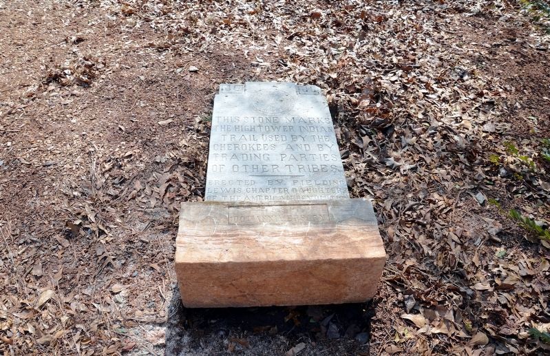
This stone marks
the Hightower Indian
Trail used by the
Cherokees and by
trading parties
of other tribes
(On the base)
1931
100th Anniversary — — Map (db m111282) HM
Already a well-established route in the 1700s, the Hightower Trail was a major Indian thoroughfare and part of a network of trails connecting Augusta with the Etowah River area and Alabama. The path crossed the Chattahoochee River at a shallow ford . . . — — Map (db m33432) HM
The Murphy families were among early pioneer settlers who migrated from Duplin and Sampson Counties, North Carolina to this area between the 1790’s and early 1800’s. This area and surrounding land was inhabited by Lower Creek Indian tribes . . . — — Map (db m40867) HM
For the last 20 miles this highway has followed the course of the noted Upper Trading Path that led from present Augusta to Indian tribes as far away as the Mississippi River. By various connections the trail reached the Cherokees of North Georgia; . . . — — Map (db m13815) HM
Little has changed here over the past century. The area remains a natural oasis for reflection, social events, and recreation.
The historic Augusta Canal, recognized as one of the most unique and intact canal systems in the United . . . — — Map (db m114327) HM
To commemorate
the courage and fidelity of
the Creek Indian Chief
William McIntosh
In his youth he shielded pioneers, during
the Revolution, from hostile tribes.
He attained distinction in the War of 1812
and . . . — — Map (db m94643) HM
[south panel]Erected in 1931 by the United States Government to commemorate the life and public service of Colonel Benjamin Hawkins who was born in Warren County, N.C. August 15, 1754 and died at the Creek Indian Agency on . . . — — Map (db m186672) HM
Here on the Flint River was the headquarters of the Agent for Indian Affairs South of Ohio until the area was acquired by Georgia in the Creek cession of Jan. 24, 1826. Here Benjamin Hawkins and David B. Mitchell, Agents, resided and in 1804 and . . . — — Map (db m394) HM
Hernando de Soto and his army after crossing to the west side of Flint River near Bainbridge, recrossed it on March 31, 1540, between the mouths of Jones and Gum creeks, and stopped at the town of the Ichisi chief. He was the first that came to . . . — — Map (db m52884) HM
Early in 1702 Joseph de Zuñiga, Spanish Governor of Florida, and Pierre le Moyne Iberville, French founder of Louisiana, made plans to check steadily increasing English trade with the Indian tribes in the interior, and perhaps to drive them out of . . . — — Map (db m22899) HM
Fort Early, built by General David Blackshear in 1812, was named for Peter Early, Governor of Georgia at that time. It was used by General Blackshear during the war of 1812. On February 13, 1818 General Andrew Jackson and his army arrived at the . . . — — Map (db m197002) HM
Just East of the railroad from here and 200 yards North of Wauhatchie Spring and Branch, stood the home of Wauhatchie, Chief of the Cherokees. In the War of 1812 he served in a company of Cherokees under Capt. John Brown, Col. Gideon Morgan and Maj. . . . — — Map (db m57996) HM
Decatur County was once a frontier region shared by the Creek and the Seminole Nations. The Creeks, comprised of dozens of loosely associate groups, lived primarily along the southern reaches of the Chattahoochee and Flint Rivers in Alabama and . . . — — Map (db m117156) HM
In this vicinity was the Indian trail which, during the period of Spanish occupation, became known as El Camino Real or King’s Highway. This road, connecting St. Augustine and Pensacola, Florida, crossed the Flint River at the trading post of James . . . — — Map (db m55920) HM
The Battle of Fowltown, fought just a few miles to the south of this spot, marked the beginning of the First Seminole War. Fowltown was a Seminole village led by Chief Neamathla which had been allied with the British during the War of 1812. It lay . . . — — Map (db m117158) HM
The area that became Decatur County played a major role in the First Seminole War. Located on the border with Spanish Florida, the region witnessed persistent violence and raiding between American settlers, Creeks and Seminoles in the early . . . — — Map (db m117154) HM
Conflict between Creeks, Seminoles and Americans continued in the years after the First Seminole War. Beginning in the 1820s in Florida, the United States pressured the Seminoles to relocate to the West. At the same time in Georgia and Alabama, the . . . — — Map (db m117160) HM
In this vicinity stood the Seminole village of Fowltown, scene of battle, Nov. 21, 1817, which marked the beginning of the First Seminole Indian War. The engagement resulted when Major Twiggs with 250 soldiers from Fort Scott attempted to arrest its . . . — — Map (db m116793) HM
The trails shown on this map of Dekalb County were a part of the great trade routes of the Indians, the Cherokees to the North and the Creeks to the South. These trails became the wagon roads of the white man. Many of them now mark the great . . . — — Map (db m142603) HM
This steatite boulder was found on the site of a prehistoric quarry along Soapstone Ridge 8 miles south of Decatur. It shows the methods of Indians in making stone bowls, with the first girdling of the stone to remove workable cores. It is . . . — — Map (db m8752) HM
The Hightower (English version of “Etowah”) Indian trail passed here in its route from East Georgia to the mountains of North Georgia. To the northwest, it crossed a ford on the Chattahoochee River at Roswell. This trade and travel path . . . — — Map (db m50372) HM
Dr. Chapmon Powell, pioneer Dekalb County physician, built this log cabin on the shallow ford Indian Trail near the town of Decatur in 1826. He often gave medical aid to Cherokee Indians still roaming the country between the shallow ford on the . . . — — Map (db m208568) HM
Hightower (Etowah) Trail, one of the best marked Indian Trails in Georgia, was a much used crossover between two of the noted Trading Paths radiating from Augusta. Recognized as a former boundary between Cherokee and Creek lands, a part of it . . . — — Map (db m33433) HM
In May 1539, Hernando de Soto landed in Florida with over 600 people, 220 horses and mules, and a herd of swine reserved for famine. Fired by his success in Pizarro’s conquest of Peru, De Soto had been granted the rights, by the King of Spain, to . . . — — Map (db m117143) HM
You are at the edge of one of the largest and most important mound groups in the southeastern United States. Most of this complex of mounds was constructed about A. D. 200-600. Archaeologists call this period the Middle Woodland Period and the . . . — — Map (db m48243) HM
A large Indian mound complex built about A.D. 200-600 is the centerpiece of Kolomoki Mounds State Park. The largest mound is 325 feet long, 200 feet wide and 57 feet high. This ceremonial area was at the eastern end of a large cleared ceremonial . . . — — Map (db m88399) HM
This road, called “Three Notch Trail” from early days, is believed to have been marked with three notches by scouts sent out by General Andrew Jackson’s troops on their march to Fort Scott. Most of his troops passed this way en route to . . . — — Map (db m48350) HM
One of the important pioneer ways, this road, called “Three Notch Trail” from early days, is believed to have been marked by scouts sent out by General Andrew Jackson to mark the route followed by Jackson’s men to Fort Scott on their way . . . — — Map (db m48349) HM
General Wiley Thompson, considered the ablest and most humane of the agents to the Seminole Indians of Florida, was ambushed and killed near the agency at Fort King, Florida, December 28, 1835, by Osceola and a band of warriors who opposed removal . . . — — Map (db m21903) HM
Van’s Creek Baptist Church, established early in 1785 by Rev. Dozier Thornton, Revolutionary soldier and Virginian, was named for an Indian convert, David Vann, famed Chief of the Cherokees. Though the 6th Baptist church in Georgia, it is the . . . — — Map (db m37342) HM
Seventeen white families from Georgia and Alabama illegally took possession of Cherokee homes here in the Beaver Dam settlement in February 1830. Cherokee Chief John Ross responded by sending a mounted police force, the Light Horse Brigade, to evict . . . — — Map (db m197528) HM
The Cherokee Nation once spread across Georgia, North Carolina, Tennessee, and Alabama. It was home to thousands of men, women, and children. The 1830 Indian Removal Act required that the Cherokee surrender their land and move west. Many actively . . . — — Map (db m197525) HM
Buried in the grave sixty feet south of this point is Esther Post Butler. Born in Connecticut on September 15, 1795, Post married Dr. Elizur Butler, physician and minister, in October 1820. The Butlers were sent by the American Board of . . . — — Map (db m109589) HM
The first residence of missionaries sent in 1821 to establish the Turnip Mountain Mission to the Cherokees was located on this site, just north of the Cemetery wall. The mission, later known as Haweis, was built two miles to the east. Sardis . . . — — Map (db m11522) HM
This tablet was placed here by
Xavier Chapter
Daughters of the American
Revolution
Oct. 10, 1901
to mark the battlefield on
which in Oct. 12, 1793
Gen'l John Sevier
met and conquered
the Indians
under their leader
King . . . — — Map (db m171090) HM
At this house’s core is the 1790s log home of Major Ridge (c.1771-1839), a leader in the Cherokee Nation. His 223-acre plantation supported numerous outbuildings, orchards and slaves while the family served as ferryboat operators and merchants. It . . . — — Map (db m14981) HM
In May 1539 Hernando de Soto landed in Florida with over 600 people, 220 horses and mules, and a herd of swine reserved for famine. Fired by his success in Pizarro's conquest of Peru. De Soto had been granted the rights, by the King of . . . — — Map (db m30462) HM
Principal Chief of the Cherokee Tribe of Indians, moved to this spot about 1794 and built this dwelling. Modernized by later owners.
His ferry & trading post made this farm a tribal center. Here was negotiated final treaty for the Cherokee . . . — — Map (db m15071) HM
The highway crossing east and west at this intersection is the Old Federal Road, first vehicular way and earliest postal route west of the Chattahoochee. Beginning to the east on the Hall-Jackson county line, it linked Georgia and Tennessee across . . . — — Map (db m21287) HM
Cherokee Chief George Welch constructed a grist mill here on his extensive homeplace c. 1820. An uncovered bridge was later added. With the 1838 removal of the Cherokees, the land was sold to Jacob Scudder. Dr. M. L. Pool purchased it from Scudder's . . . — — Map (db m14944) HM
This County, created by Act of the Legislature Feb. 25, 1784, is named for Benjamin Franklin, Revolutionary patriot and statesman. It was formed from lands obtained from the Indians by the Treaty of Augusta, 1783. Capt. James Terrell of the . . . — — Map (db m27043) HM
Development along Indian trails of the Old Federal Road began in the early 19th century to improve transportation between South Carolina and Tennessee. Although European settlement in this area began in the late 1700s, the road increased populations . . . — — Map (db m15020) HM
On the rise above this marker is the family cemetery of Major J. M. C Montgomery (1770-1842) probably the first white man to settle permanently in what is now Fulton County. A soldier in the War of 1812, Montgomery served under Lt. George R. Gilmer . . . — — Map (db m21516) HM
Sand Town (Oktahatalofa) and Buzzard Roost (Sulecauga) were two frontier Creek Indian communities here on the Chattahoochee River. The old Sand Town Trail extended westward to the Coosa River in Alabama and eastward into what is now DeKalb County. . . . — — Map (db m14157) HM
A Creek Indian village on both sides of the river at mouth of Peachtree Cr. Whether it was named for a "pitch tree" or a peach tree, it occurs, officially, as Standing Peach Tree in Gov. John Martin's letter of May 27, 1782, to Gen. Andrew Pickens . . . — — Map (db m22090) HM
First the Cherokee Indians were here. Then the White settlers were here. Among the first of these was Edwin Plaster who built his home near here. He grew cotton on this plot of land, and built the first permanent bridge across Peachtree Creek. He . . . — — Map (db m14413) HM
This community is named for the natural springs bubbling up through clear white sand in the meadow below. The Springs were a Cherokee and Creek Indian campsite which became the property of the orphans of John Medows of Henry County in the 1821 Land . . . — — Map (db m9544) HM
This was the Courthouse of Campbell County at the time it was merged with Fulton County Jan. 1, 1932. When the County was created by Acts of the Legislature Dec. 20 & 22, 1828, the Site was at Campbellton on the Chattahoochee but it was moved to . . . — — Map (db m32709) HM
Circa late 1830s, homestead of Brigadier General and State Senator Eli McConnell and his wife Savilla Garrison. This house was one of the first in the original Cherokee County, established in December 1832. Governor Troup authorized McConnell to . . . — — Map (db m118146) HM
This clapboard house was built in 1899 by Willis Cass Tucker, Jr., and his wife Dealphia Jane Wheeler on an original 40-acre land lot from the 1832 lottery of Cherokee Indian lands. It typifies turn of the century Georgia farmhouses. Tucker sold it . . . — — Map (db m118159) HM
At this point the noted Hightower (Etowah) Indian Trail crossed today’s Azalea Drive. With connections from Charleston, via Augusta, the old thoroughfare ran through this section to reach the Indian towns of present - day northwest Georgia. The . . . — — Map (db m33436) HM
Originally constructed by a Cherokee Indian as a one room cottage with a fireplace. It was enlarged and the front entrance turned to face Canton Street in the early 1900s. The house was occupied for many years by Mr. & Mrs. Charles C. Fowler, . . . — — Map (db m109212) HM
General Winfield Scott put the Cherokee removal into action in 1838. The Cherokee remained in their homes despite continuous warnings and directives to gather at the forts. “Cherokees! The President of the United States has sent me with a . . . — — Map (db m171956) HM
In 1838, the majority of the Cherokees, approximately 12,000, were forced onto the “Trail of Tears”. Only about 8,000 made it to the new Cherokee Nation – what is now called Tehlequah, Oklahoma. After being imprisoned for several . . . — — Map (db m171953) HM
This monument is a memorial to the Cherokees who were driven from their land and their homes against their will in 1838. Thousands died on the Nunna-da-ul-tsun-yi, commonly translated as “The Trail of Tears”. Roswell honors the Cherokee . . . — — Map (db m171958) HM
Named after a well known local Native American, Willeo, who lived along present-day Willeo Creek in the early 1800s. According to legend, he may have been an original church member. Willeo Baptist has played an important role in the Christian life . . . — — Map (db m109387) HM
Hightower (Etowah) Trail, one of the best marked Indian trails in Georgia, and a main road along which many settlers built their homes until the 1840’s, crossed this highway near here on its way to a nearby ford on the Chattahoochee River. A . . . — — Map (db m33435) HM
In 1838, 1100 Cherokee Indians
were assembled at this site in
preparation for the evacuation
to Oklahoma Territory on
The Trail of Tears — — Map (db m98987) HM
Home of the Cherokee Indian Chief Whitepath stood from 1800 to 1982, 338 yards S.W. of this marker. Aaron Pinson born Feb. 5, 1784 lived here from 1838 until his death Dec. 7, 1843 — — Map (db m98998) HM
Brunswick's first settler came to Georgia in 1738 with Oglethorpe's regiment. He was granted 500 acres at this place, on which he established his plantation.
Several tabby buildings erected by him stood nearby and a military outpost was . . . — — Map (db m12429) HM
Wright Square, one of the two largest of the original 14 squares of Brunswick, was named after Georgia’s last Colonial Governor, Sir James Wright (1716-1785). Well-respected and fair, Wright held his office from October 13, 1760 until the end of . . . — — Map (db m212684) HM
The skirmish at Bloody Marsh was more than a battle.
It was a clash of cultures - each vying for control of
what is now the southeastern United States.
Soldiers from Hispanic colonies in the New World
fought under the Spanish banner, with the . . . — — Map (db m63869) HM
The Spanish established several
missions along Georgia's coastal sea
islands. Two missions were located on
St. Simons Island, called " Isla De
Guadalquini" by the Spanish: Santo
Domingo de Asajo (Guale) and San
Buenaventura de . . . — — Map (db m13431) HM
Mary Musgrove Matthews " has always
been in great esteen with the General,... for
being half Indian by extract, she had a very
great influence upon many of them, particulary
the Creek Nation...."
William Stephens
February 22, 1740 . . . — — Map (db m18908) HM
Throughout the ages Gascoigne Bluff has been the gateway to St. Simons Island. An Indian village was located here. Capt. James Gascoigne of HM Sloop-of-war, HAWK, which convoyed the Frederica settlers on their voyage across the Atlantic in 1736, . . . — — Map (db m12229) HM
Throughout the ages Gascoigne Bluff has been the gateway to St. Simons Island. An Indian village was located here. Capt. James Gascoigne of HM Sloop-of-was, HAWK, which convoyed the Frederica settlers on their voyage across the Atlantic in 1736, . . . — — Map (db m13415) HM
St. Simons park was the site of a Mocama Indian village of approximately 100-200 people. The inhabitants used marine resources, agriculture, square wattle and daub houses, stamped and incised Irene style ceramics, and burial mounds characteristic . . . — — Map (db m12262) HM
This road, formerly an Indian trail which paralleled the coast, was used by the Spanish and British. In 1778 it was traveled by Revolutionary soldiers who marched against Fort Tonyn. The first mail service south of Savannah was established over . . . — — Map (db m14444) HM
During the early 1800’s, northern Georgia was heart of the sovereign, independent Cherokee Indian Nation. By this time Cherokee were the most progressive Indian tribe in North America. In 1821, they became the first American Indians with a written . . . — — Map (db m11567) HM
The two-story portion of this house was the Oothcaloga Moravian Mission Station, serving this region of the Cherokee Nation from 1822 until 1833. John Gambold, whose grave lies 100 yards east, was first missionary here.
Built in 1821 by . . . — — Map (db m60002) HM
Erected in honor of the Cherokee Nation by the United States Government in 1931 on the site of New Echota, last capital of the Cherokee Indians east of the Mississippi River.
The Cherokee Nation, composed of twenty thousand people, occupied . . . — — Map (db m65817) HM
The Cherokee Nation of Indians established the first Indian-language newspaper, the Cherokee Phoenix, on this site in 1828. Edited by Cherokee Elias Boudinot and later by Elijah Hicks, the Cherokee Phoenix was printed bi-lingually in the . . . — — Map (db m65819) HM
The sprawling town of New Town which had stood here since 1819 was designated the seat of government for the Cherokee Nation in a legislative act of 1825 and it was renamed New Echota for a former principal town in Tennessee. In its short history . . . — — Map (db m67572) HM
On the hilltop, 100 yards to the south, is the cemetery for the village of New Echota. The marked graves are those of Pathkiller, Principal Chief of the Cherokee Nation until his death in 1827 and a colonel in Morgan's regiment in the War of 1812, . . . — — Map (db m11570) HM
The head of the Oostanaula River is formed 200 yards northeast by the confluence of the Coosawattee and the Conasauga Rivers. The passage of travelers and freight along the Tennessee Road was served at this point by a ferry operated by the . . . — — Map (db m11057) HM
Originator of the Cherokee Indian alphabet.
Two miles east of this spot is New Echota, the last Indian capital in Georgia, where Sequoyah lived.
Here was published the "Cherokee Phoenix," only
newspaper edited in an Indian language. . . . — — Map (db m87047) HM
The New Echota Treaty of 1835 relinquished Cherokee Indian claims to lands east of the Mississippi River. The majority of the Cherokee people considered the treaty fraudulent and refused to leave their homelands in Georgia, Alabama, North . . . — — Map (db m10051) HM
Two Cherokee families headed by Elijah Hicks and Alexander McCoy were among the first residents of New Echota. Both families were already living here when New Echota became the capital in 1825. Their farms once included most of what is now the golf . . . — — Map (db m161553) HM
About two miles South, in the fork of the Appalachee and Oconee rivers, stood Fort Mathews, built in 1793. From this fort, Thomas Houghton observed the activities of General Elijah Clark and his land hungry followers as they built forts and . . . — — Map (db m15809) HM
When Bethesda Baptist Church was organized in 1785, it was known as Whatley’s Mill Church, and was in Wilkes County before it was added to Greene in 1802. When the present building was erected in 1818, the name was changed to Bethesda. Jesse Mercer . . . — — Map (db m24724) HM
This site is described in the treaty signed by the Creek and Cherokee Indians at Augusta, Georgia, in 1773. Here began the survey of the ceded lands. — — Map (db m15712) HM
These stone structures range from neatly stacked cubic assemblies to scattered piles of rock (that appear to formerly have been neatly stacked). Some are stacked five to six feet tall. There are hundreds of these mounds scattered in various . . . — — Map (db m114344) HM
At Fort Daniel on Hog Mountain, about 12 miles NE, began the original Peachtree Road to the village of Standing Peachtree on the Chattahoochee River. This old road was opened to haul military supplies to the river. These were to be floated . . . — — Map (db m21577) HM
The Norcross Historic District has been preserved as a 19th century railroad town, and its historical significance has been recognized by the U. S. Department of the Interior through its listing on the National Register of Historic Places on . . . — — Map (db m35039) HM
The Eastern Continental Divide is a naturally occurring high ridge in the eastern United States that separates falling water into streams and rivers that flow into either the Atlantic Ocean or the Gulf of Mexico. The ridge begins in the Allegheny . . . — — Map (db m212999) HM
Norcross was incorporated in 1870
by John J. Thrasher, a pioneer Atlanta settler who named this town after his good friend and business associate, Jonathan Norcross. The town of Norcross was the second city in Gwinnett County, and the first . . . — — Map (db m221159) HM
The historic Blair line between the State of Georgia and the Cherokee Nation crossed this highway at this point. This line was surveyed by James Blair in the early 1800’s. It ran from the forks of the Soque and Chattahoochee rivers in a direct . . . — — Map (db m43670) HM
with 500 Spanish and Portugese soldiers and with 200 Cherokee burden bearers passed here about May 30th 1540 twenty six years before the founding of St. Augustine — — Map (db m173169) HM
The Unicoi Turnpike, first vehicular route to connect North Georgia and Tennessee with the head of navigation on the Savannah River system, passed here. Beginning on the Tugalo River to the east of Toccoa, the road led this way, thence across . . . — — Map (db m43671) HM
This highway runs along the divide between the Atlantic Ocean and the Gulf of Mexico. On the south the waters run into the Broad and Savannah rivers to the Atlantic Ocean. Waters on the north run into Chattahoochee and Apalachicola rivers and the . . . — — Map (db m21065) HM
The route leading west from this point is the Old Federal Road, an early thoroughfare which linked Georgia and Tennessee across the Cherokee Nation. Rights to open the passage were granted informally by the Indians in 1803 and confirmed by treaty in . . . — — Map (db m24718) HM
In memory of the pioneer citizens who gave a great heritage to this area, this plaque was presented December 19, 1968 to commemorate the 150th anniversary of the creation of Hall County, 44th county of Georgia. Named for Lyman Hall, one of the three . . . — — Map (db m23154) HM
Near the mouth of Shoulder-bone Creek on the banks of the Oconee River a treaty of "amity, peace and commerce" was signed by eight commissioners representing the State of Georgia and 59 head men of the Creek Confederation, November 3, 1786. Among . . . — — Map (db m186657) HM
Sparta, Seat of Justice for Hancock County in 1795, became a chartered town, Dec. 3, 1803. Situated at an Indian trading post, in constant danger of border trouble, the town was named Sparta to indicate the bravery of its pioneer citizens. In 1864 . . . — — Map (db m24343) HM
The Upper Trading Path, one of the historic Indian ways of the Southeast, passed here, leading westward from present Augusta to tribes as far away as the Mississippi River. By various connections the route reached the Muscogees of Western Georgia . . . — — Map (db m48878) HM
Tallapoosa was a place of great ceremonial importance to the Indians. Here in 1826 settlers discovered “Charles Town,” an Indian Village named for one of their great warriors. Several Indian trails intersected here and the Choctaw, Creek . . . — — Map (db m11142) HM
This road was originally the Sandtown Trail traveled by several tribes of Creek Indians. It connected Sandtown on the Chattahoochee River near Atlanta, Ga. with another Sandtown in Tallapoosa Co., Ala. Later became Old Ala. Road over which early . . . — — Map (db m11176) HM