After filtering for Missouri, 370 entries match your criteria. The first 100 are listed. ⊳
African Americans Topic
By William Fischer, Jr., October 30, 2010
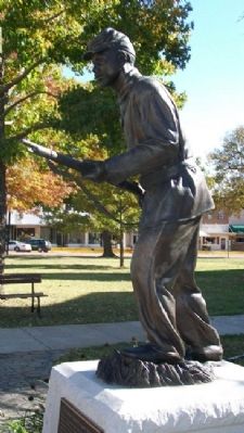
"First Kansas Colored Volunteer Infantry" Statue
| 1 ► Missouri, Bates County, Butler — “First Kansas Colored Volunteer Infantry” — They Fought Like Tigers — |
| On Ohio Street at Delaware Street, on the left when traveling west on Ohio Street. | |||
| 2 ► Missouri, Bates County, Butler — Bates County, Missouri in 1862 — |
| Near Marth Road (Road 1002) near Cooper Road (County Road 5001). | |||
| 3 ► Missouri, Bates County, Butler — Battle of Island Mound Memorial — |
| On Marth Road (County Road 1002) east of Cooper Road (County Road 5001), on the left when traveling west. | |||
| 4 ► Missouri, Bates County, Butler — First Kansas Colored Volunteer Infantry Regimental History — |
| On Marth Road (County Route 1002) near Cooper Road (County Route 5001), on the left when traveling west. | |||
| 5 ► Missouri, Bates County, Butler — Prairie Fire and the Battle of Island Mound — |
| Near Marth Road (County Road 1002) near Cooper Road (County Road 5001). | |||
| 6 ► Missouri, Bates County, Butler — The Battle of Island Mound — |
| On Marth Road (County Route 1002) near Cooper Road (County Route 5001), on the left when traveling west. | |||
| 7 ► Missouri, Bates County, Butler — The Battle of Island Mound: A Demonstration to the Nation — |
| On Marth Road (County Road 1002) near Cooper Road (County Road 5001), on the left when traveling west. | |||
| 8 ► Missouri, Bates County, Butler — The Toothman Farm — Home to a Notorious Rebel Family — |
| On Marth Road (County Road 1002) near Cooper Road (Road 5001), on the left when traveling west. | |||
| 9 ► Missouri, Boone County, Columbia — "Make A Brighter Future" — |
| On East Stewart Road just west of South Providence Road (State Highway 163), in the median. | |||
| 10 ► Missouri, Boone County, Columbia — 3rd Street Market, Blue & White Café, and the Harvey House — |
| On North Providence Road (State Highway 163) just north of Switzler Street, on the left when traveling north. | |||
| 11 ► Missouri, Boone County, Columbia — African American Heritage Trail — |
| On Park Avenue just east of North Providence Street (State Highway 163), on the right when traveling east. | |||
| 12 ► Missouri, Boone County, Columbia — African-American Heritage — Flat Branch Park — |
| On South 4th Street at Cherry Street, on the right when traveling south on South 4th Street. | |||
| 13 ► Missouri, Boone County, Columbia — African-American Heritage Trail — |
| On East Broadway just east of North 4th Street, on the left when traveling east. | |||
| 14 ► Missouri, Boone County, Columbia — African-American Heritage Trail — |
| On North 5th Street at East Walnut Street, on the right when traveling north on North 5th Street. | |||
| 15 ► Missouri, Boone County, Columbia — African-American Heritage Trail — |
| On South 5th Street at Davis Street, on the right when traveling north on South 5th Street. | |||
| 16 ► Missouri, Boone County, Columbia — African-American Heritage Trail — |
| On North 5th Street just north of East Ash Street, on the left when traveling north. | |||
| 17 ► Missouri, Boone County, Columbia — African-American Heritage Trail — |
| On East Broadway, 0.1 miles west of North 1st Street, on the left when traveling west. | |||
| 18 ► Missouri, Boone County, Columbia — African-American Heritage Trail — |
| On North Garth Avenue at East Ash Street, on the right when traveling north on North Garth Avenue. | |||
| 19 ► Missouri, Boone County, Columbia — African-American Heritage Trail — |
| On North Providence Road (State Highway 163) at East Ash Street, on the left when traveling north on North Providence Road. | |||
| 20 ► Missouri, Boone County, Columbia — African-American Heritage Trail — |
| On Switzler Street just west of Lasalle Place, on the right when traveling west. | |||
| 21 ► Missouri, Boone County, Columbia — African-American Heritage Trailhead — |
| On South 4th Street at Cherry Street, on the right when traveling south on South 4th Street. | |||
| 22 ► Missouri, Boone County, Columbia — Annie Fisher's House — African-American Heritage Trail — |
| On Park Avenue at North 7th Street, on the right when traveling east on Park Avenue. | |||
| 23 ► Missouri, Boone County, Columbia — Douglass Park and Pool, Russell Chapel — African-American Heritage Trail — |
| On North Providence Road (State Highway 163) just north of Switzler Street, on the right when traveling north. | |||
| 24 ► Missouri, Boone County, Columbia — In Loving Memory of Mrs. Beulah Ralph — |
| On North Providence Road (State Highway 163) at Boone Drive, on the right when traveling north on North Providence Road. | |||
| 25 ► Missouri, Boone County, Columbia — In Memory of the United States Colored Troops of the Civil War — Known to Be Buried in Columbia Cemetery — |
| Near East Broadway just west of North 1st Street, on the left when traveling west. | |||
| 26 ► Missouri, Boone County, Columbia — Lest We Forget: Lynching at the Stewart Road Bridge — |
| Near South Providence Road (State Highway 163) 0.1 miles south of East Stewart Road, on the left when traveling north. | |||
| 27 ► Missouri, Boone County, Columbia — Sharp End — |
| On East Walnut Street just east of North 5th Street, on the right when traveling east. | |||
| 28 ► Missouri, Boone County, Columbia — The John William "Blind" Boone Home and the Second Missionary Baptist Church — |
| On North 4th Street just north of East Broadway, on the right when traveling north. | |||
| 29 ► Missouri, Boone County, Columbia — The Wynna Faye Tapp-Elbert Memorial Amphitheater — In Celebration of her life and Achievements in the City of Columbia — October 2, 1944 - February 9, 2014 — |
| On North 5th Street just south of Rogers Street, on the left when traveling north. | |||
| 30 ► Missouri, Boone County, Columbia — Tibbs Building — African American Heritage Trail — |
| On East Walnut Street at North 5th Street, on the right when traveling east on East Walnut Street. | |||
| 31 ► Missouri, Buchanan County, St. Joseph — A Path To Freedom — Finding refuge across the river — |
| 32 ► Missouri, Buchanan County, St. Joseph — Coleman Randolph "Hawk" Hawkins — November 21, 1904 - May 19, 1969 — "Body and Soul" — |
| On Felix Street at 7th Street, on the left when traveling east on Felix Street. | |||
| 33 ► Missouri, Callaway County, Fulton — War Comes to Westminster College — Missouri's Civil War — |
| On Westminster Avenue at 5th Street, on the left when traveling north on Westminster Avenue. | |||
| 34 ► Missouri, Cape Girardeau County, Cape Girardeau — Cape Girardeau Freedom Rock Veterans Memorial — Honoring Cape Girardeau County Veterans — Ray "Bubba" Sorensen II — |
| Near North Kingshighway Street (U.S. 61) at County Park Drive, on the right when traveling north. | |||
| 35 ► Missouri, Cape Girardeau County, Cape Girardeau — Entertainers — |
| On Water Street. | |||
| 36 ► Missouri, Cape Girardeau County, Cape Girardeau — George Washington Carver — |
| On Water Street. | |||
| 37 ► Missouri, Cape Girardeau County, Cape Girardeau — Ivers Square Civil War Monuments — Old Town Cape — |
| On North Lorimier Street just north of Themis Street, on the right when traveling north. | |||
| 38 ► Missouri, Cape Girardeau County, Cape Girardeau — The Civil War / The Boys of Summer / Sports Dazzlers — |
| On Water Street. | |||
| 39 ► Missouri, Cass County, Harrisonville — Wayside Rest — The Robert Allison Brown House — Circa 1850 — |
| On Prettyman Road, 1.2 miles west of Missouri Route 291, on the left when traveling north. | |||
| 40 ► Missouri, Clay County, Liberty — Clay County African American Pioneers — |
| On Franklin Street at Water Street, on the left when traveling west on Franklin Street. | |||
| 41 ► Missouri, Clay County, Liberty — Lewis and Clark Mural — Dedicated June 24, 2005 — Artist: David McClain — |
| On Water Street at Mill Street, on the left when traveling north on Water Street. | |||
| 42 ► Missouri, Clay County, Liberty — St. Luke A.M.E. Church — Clay County Historical Society — Historic Landmark — |
| On Main Street, on the right when traveling north. | |||
| 43 ► Missouri, Cole County, Jefferson City — Corps of Discovery — (1804 - 1806) — |
| On Jefferson Street at Capitol Avenue, on the left when traveling north on Jefferson Street. | |||
| 44 ► Missouri, Cole County, Jefferson City — During the next four decades — ★ Sacrifice ★ Education ★ Equality ★ Humanity ★ Courage ★ — |
| On Chestnut Street, 0.1 miles north of Dawson Drive, on the left when traveling north. | |||
| 45 ► Missouri, Cole County, Jefferson City — Lincoln University was founded — ★ Sacrifice ★ Education ★ Equality ★ Humanity ★ Courage ★ — |
| On Chestnut Street, 0.3 miles north of East Atchison, on the left when traveling north. | |||
| 46 ► Missouri, Cole County, Jefferson City — Soldiers' Memorial Plaza — |
| On Chestnut Street north of Atchison Street, on the left when traveling north. | |||
| 47 ► Missouri, Cole County, Jefferson City — The founding of Lincoln University — Lincoln University, Jefferson City, Missouri — ★ Sacrifice ★ Education ★ Equality ★ Humanity ★ Courage ★ — |
| On Chestnut Street just north of Dawson Drive, on the left when traveling north. | |||
| 48 ► Missouri, Cole County, Jefferson City — Towards the end of the war — ★ Sacrifice ★ Education ★ Equality ★ Humanity ★ Courage ★ — |
| On Chestnut Street, 0.1 miles Dawson Drive, on the left when traveling north. | |||
| 49 ► Missouri, Cole County, Jefferson City — With the deeding of the property to the state in 1879 — ★ Sacrifice ★ Education ★ Equality ★ Humanity ★ Courage ★ — |
| On Chestnut Street, 0.1 miles north of Dawson Drive, on the left when traveling north. | |||
| 50 ► Missouri, Cole County, Jefferson City — Woodland-Old City Cemetery — |
| On East McCarty Street, 0.1 miles west of Locust Street, on the left when traveling west. | |||
| 51 ► Missouri, Cooper County, Boonville — James Milton Turner — (1839 - 1915) — |
| On Morgan Street near Main Street (U.S. 40), on the left when traveling east. | |||
| 52 ► Missouri, Daviess County, Jamesport — Harris Log House — |
| On Broadway (Missouri Route 190) at Bailey Street, on the right when traveling north on Broadway. | |||
| 53 ► Missouri, Franklin County, New Haven — Anna Bell Chapel — [African Methodist Episcopal Church of New Haven] — |
| On Selma Street at High Street, on the right when traveling north on Selma Street. | |||
| 54 ► Missouri, Franklin County, New Haven — Historic New Haven |
| On Main Street west of Cottonwood, on the right when traveling west. Reported damaged. | |||
| 55 ► Missouri, Franklin County, Union — Lynching in America / Lynching of Erastus Brown — Community Remembrance Project — |
| Near Prairie Dell Road. | |||
| 56 ► Missouri, Franklin County, Washington — 34 — Southern Presbyterian Church — 1868 — |
| On East 2nd Street west of Market Street, on the right when traveling west. | |||
| 57 ► Missouri, Franklin County, Washington — St. John's A.M.E. Church — 1891 — |
| On Walnut Street at East 4th Street, on the right when traveling north on Walnut Street. | |||
| 58 ► Missouri, Greene County, Springfield — Bobby Bell — |
| On Stan Musial Drive south of U.S. 60, on the right when traveling west. | |||
| 59 ► Missouri, Greene County, Springfield — John Jordan "Buck" O'Neil — |
| On Stan Musial Drive south of U.S. 60, on the right when traveling west. | |||
| 60 ► Missouri, Greene County, Springfield — Louis Clark Brock — |
| On Stan Musial Drive south of U.S. 60, on the right when traveling west. | |||
| 61 ► Missouri, Greene County, Springfield — Osborne Earl "Ozzie" Smith — |
| On Stan Musial Drive south of U.S. 60, on the right when traveling west. | |||
| 62 ► Missouri, Greene County, Springfield, Downtown Springfield — Lynching in America / The Lynchings of Horace B. Duncan, Fred Coker and William Allen — Community Remembrance Project — |
| On Park Central Square east of South Avenue, on the right when traveling east. | |||
| 63 ► Missouri, Greene County, Springfield, Downtown Springfield — Three Black Men Lynched — |
| Near Park Central Square west of E St. Louis Street. | |||
| 64 ► Missouri, Greene County, Springfield, Midtown — Historic Washington Avenue Baptist Church — |
| On Bob Barker Boulevard at Drury Lane, on the right when traveling west on Bob Barker Boulevard. | |||
| 65 ► Missouri, Howell County, Mountain View, Goldsberry Township — George Washington Carver Green Ash — |
| Near North Pine Street just north of West 4th Street, on the left when traveling north. | |||
| 66 ► Missouri, Jackson County, Independence — 22 — "The Neck" — Truman Historic Walking Tour Stop 22 |
| On North Delaware Street at Northwest Parkway, on the right when traveling south on North Delaware Street. Reported missing. | |||
| 67 ► Missouri, Jackson County, Independence — A Man of Means — Santa Fe, Oregon and California National Historic Trails — |
| On West College Street at North McCoy Street, on the right when traveling west on West College Street. | |||
| 68 ► Missouri, Jackson County, Independence — First Christian Church — |
| On South Pleasant Street, 0 miles north of West Kansas Avenue, on the right when traveling north. | |||
| 69 ► Missouri, Jackson County, Independence — Second Baptist Church — |
| On East White Oak Street just east of North Lynn Street, on the right when traveling west. | |||
| 70 ► Missouri, Jackson County, Independence, East Side — Thomson House |
| On U.S. 40 at East 36th Street, on the left when traveling east on U.S. 40. Reported permanently removed. | |||
| 71 ► Missouri, Jackson County, Kansas City, 18th And Vine — American Jazz Museum — |
| Near Vine Street north of 18th Street, on the right when traveling north. | |||
| 72 ► Missouri, Jackson County, Kansas City, 18th And Vine — Negro Leagues Baseball Museum — |
| On Vine Street north of 18th Street, on the right when traveling north. | |||
| 73 ► Missouri, Jackson County, Kansas City, Columbus Park — Garrison Field House — |
| On East 5th Street west of Forest Avenue, on the right when traveling west. | |||
| 74 ► Missouri, Jackson County, Kansas City, Downtown Kansas City — Ed Hogan — |
| On Madison Street north of West 8th Street, on the left when traveling south. | |||
| 75 ► Missouri, Jackson County, Kansas City, Downtown Kansas City — John "Buck" O'Neil Center — |
| On The Paseo at 19th Street, on the left when traveling north on The Paseo. | |||
| 76 ► Missouri, Jackson County, Kansas City, Downtown Kansas City — Richard Thomas Coles / R.T. Coles Vocational and Junior High School — |
| On East 19th Street at Tracy Avenue, on the right when traveling west on East 19th Street. | |||
| 77 ► Missouri, Jackson County, Kansas City, Downtown Kansas City — Slavery in Kansas City — |
| On Madison Street north of West 8th Street, on the right when traveling north. | |||
| 78 ► Missouri, Jackson County, Kansas City, East Side — Amos Otis — |
| On Brooklyn Avenue at East 22nd Street, on the right when traveling south on Brooklyn Avenue. | |||
| 79 ► Missouri, Jackson County, Kansas City, East Side — Bobby Bell — |
| On Brooklyn Avenue at East 22nd Street, on the right when traveling south on Brooklyn Avenue. | |||
| 80 ► Missouri, Jackson County, Kansas City, East Side — Jackie Robinson — |
| On Brooklyn Avenue at East 22nd Street, on the right when traveling south on Brooklyn Avenue. | |||
| 81 ► Missouri, Jackson County, Kansas City, East Side — John Jordan "Buck" O'Neil — |
| On Brooklyn Avenue at East 22nd Street, on the right when traveling south on Brooklyn Avenue. | |||
| 82 ► Missouri, Jackson County, Kansas City, East Side — John Mayberry — |
| On Brooklyn Avenue at East 22nd Street, on the right when traveling south on Brooklyn Avenue. | |||
| 83 ► Missouri, Jackson County, Kansas City, East Side — John Thomas Wyatt — |
| On Brooklyn Avenue at East 22nd Street, on the right when traveling south on Brooklyn Avenue. | |||
| 84 ► Missouri, Jackson County, Kansas City, East Side — Kansas City Call — |
| On 18th Street east of Woodland Avenue, on the right when traveling east. | |||
| 85 ► Missouri, Jackson County, Kansas City, East Side — Kansas City Municipal Stadium — |
| On Brooklyn Avenue at East 22nd Street, on the right when traveling south on Brooklyn Avenue. | |||
| 86 ► Missouri, Jackson County, Kansas City, East Side — Leroy Robert "Satchel" Paige — |
| On Brooklyn Avenue at East 22nd Street, on the right when traveling south on Brooklyn Avenue. | |||
| 87 ► Missouri, Jackson County, Kansas City, East Side — Ms. Myra Taylor — Composer, and Jazz Legend — "Take It Easy, Greasy" — |
| On 18th Street at Woodland Avenue, on the right when traveling east on 18th Street. | |||
| 88 ► Missouri, Jackson County, Kansas City, East Side — Municipal Stadium — |
| On Brooklyn Avenue at East 22nd Street, on the right when traveling south on Brooklyn Avenue. | |||
| 89 ► Missouri, Jackson County, Kansas City, East Side — Mutual Musicians Association Building — |
| On Highland Avenue, on the right when traveling north on Highland Avenue. | |||
| 90 ► Missouri, Jackson County, Kansas City, East Side — Otis Taylor — |
| On Brooklyn Avenue at East 22nd Street, on the right when traveling south on Brooklyn Avenue. | |||
| 91 ► Missouri, Jackson County, Kansas City, East Side — Roy Wilkins — |
| On 18th Street east of Woodland Avenue, on the right when traveling east. | |||
| 92 ► Missouri, Jackson County, Kansas City, East Side — Willie Lanier — |
| On Brooklyn Avenue at East 22nd Street, on the right when traveling south on Brooklyn Avenue. | |||
| 93 ► Missouri, Jackson County, Kansas City, Neighborhood United for Action — Leroy Robert "Satchel" Paige — |
| Near Troost Avenue, 0.2 miles north of 71st Street. | |||
| 94 ► Missouri, Jackson County, Kansas City, Parkview — Goin' to Kansas City Plaza — at Twelfth Street and Vine — 12th Street & Vine: Kansas City's World Address — |
| On East 12th Street east of The Paseo. | |||
| 95 ► Missouri, Jackson County, Kansas City, Quality Hill — Lynching in America / Lynching of Levi Harrington — Community Remembrance Project — |
| Near Summit Street at West 10th Street. | |||
| 96 ► Missouri, Jackson County, Kansas City, South Kansas City — Hiram Young — Wagon Manufacturer — |
| On East Red Bridge Road, on the right when traveling east. | |||
| 97 ► Missouri, Jackson County, Kansas City, South Kansas City — James Beckwourth — Fur Trapper and Trail Blazer — |
| On East Red Bridge Road, on the right when traveling west. | |||
| 98 ► Missouri, Jackson County, Kansas City, South Kansas City — People and the Trails — Santa Fe, Oregon and California National Historic Trails — |
| On East Red Bridge Road, on the right when traveling west. | |||
| 99 ► Missouri, Jackson County, Kansas City, South Kansas City — Remembrance of Trails Past — |
| On East 99th Street east of Holmes Road, on the right when traveling west. | |||
| 100 ► Missouri, Jasper County, Joplin — Battle of Rader's Farm — May 18, 1863 — |
370 entries matched your criteria. The first 100 are listed above. Next 100 ⊳