On State Highway 11 west of County Road 630, on the left when traveling west.
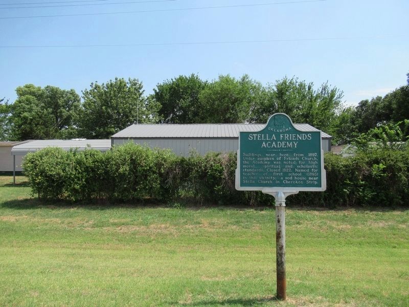
Buildings near here from 1897. Under auspices of Friends Church, the Academy was noted for high moral, spiritual and scholastic standards. Closed 1922. Named for the teacher of first school (1893) in this vicinity, a sod house near Stella Church . . . — — Map (db m216941) HM
On Mendenhall Street (County Route 12) 0.1 miles north of Panhandle Street (U.S. 64), on the right when traveling north.
Eureka was established in 1908 with 18 square miles. The high school was started in 1919 when Center, Lincoln, and one half of Pleasant View were consolidated. In 1923, the Nabisco, Happy Flat, and East Banner districts were added and a new building . . . — — Map (db m78816) HM
On County Highway 1230 at County Highway 2000, on the left when traveling west on County Highway 1230.
In honor of the people who lived here from 1892 to 1957, and built this community.
Life in the community, which at one time included 2 general stores, a barber shop, blacksmith shop, grain grinding mills, church and family residences, centered . . . — — Map (db m209528) HM
Jaycee project 1976
Rock Bluff School
Est. 1894-1926
Donated by Trigg Music Family
Cornerstone:
Rock Bluff School
1894 - 1976
Building donated by
The Trigg Music Family
Ron Savage Jr. Chairman
Western Oklahoma . . . — — Map (db m162462) HM
In 1888 Thomas and Millie Price were one of the first families to settle in this portion of old Greer Co, now Beckham Co. Price built a cotton gin ½ mi. east of Delhi in 1903. The one-roomed Delhi Academy was established in 1921. The Academy . . . — — Map (db m54903) HM
On North 4th Street (U.S. 283) at Elm Avenue, on the right when traveling north on North 4th Street.
This underpass was a 1939 WPA Works Project. In 1939 the Sayre Grade School was located one block east of this location the underpass was built to provide safe passage for children and pedestrians crossing under the very busy Route 66. It is still a . . . — — Map (db m187260) HM
On U.S. 70, 0.1 miles east of Ballpark Road, on the right when traveling west.
Armstrong Academy, established by Choctaw Nation and named for Wm. Armstrong, Indian Agt., was opened in 1845. Rev. R.D. Potts, Supt., under Baptist Miss. Soc. Post Office established Nov., 1850. Confederate Capitol during Civil War. Choctaw . . . — — Map (db m77938) HM
On Buffalo Street (State Highway 22) west of Main Street, on the right when traveling east.
Built by Woodmen of the World, this site has served businesses as well as Caddo schools as a classroom. One of its most famous occupants was John L. "Judge" Boland, opening a law office in 1910. He served as city attorney and a civic leader . . . — — Map (db m73426) HM
On U.S. 281, 0.1 miles north of Wichita Lane, on the right when traveling north.
This school opened at the Indian agency on Sugar Creek with 8 pupils. A new building was erected as a boarding school in 1872, for Wichita and Caddo children. Fire in 1878 destroyed the school. It soon reopened in a new building here on the Washita . . . — — Map (db m166713) HM
On State Highway 152, 1.5 miles east of U.S. 281, on the right when traveling east.
Established in 1911 and known as Science Hill. The school house was located one half mile east of this memorial. Later the name was changed to Britton School in honor of the pioneer family. The church located at the same site served as a Grade . . . — — Map (db m142497) HM
The Commander's Quarters was constructed in 1876. This building underwent major renovations during the WPA period in the late 1930's. Last remodeled in 2014, the building is home to BlueSTEM AgriLearning Center. This STEM (science, technology, . . . — — Map (db m171131) HM
On D Street NW north of 9th Avenue NW, on the right when traveling north.
A Methodist college once stood here. Begun by the City of Ardmore it was given to the Indian Mission Conference of the Methodist Church. Named in honor of Bishop Robt. K. Hargrove. In 1907 the school burned but was rebuilt north of the city. It . . . — — Map (db m141620) HM
Near South Keeler Drive, 0.3 miles south of East Willis Road (County Route D0790), on the left when traveling south.
(front)
The United States Government, unable to conclude an agreement with the duly authorized leaders of the Cherokee Nation, signed a treaty with a minority faction willing to cede the last remaining portion of the original Cherokee . . . — — Map (db m77932) HM
On North 4200 Road west of Old Spring Road, on the left when traveling west.
Begun 1848 by Rev. John Lathrop of American Bd. of Foreign Miss. Rev. O.P. Stark, Supt. (1850), built 1st church. Mrs. Stark opened 1st school here. Others in the service through 100 years include W.J.B. Lloyd, J.P. Gibbons, Bella M. Gibbons, Silas . . . — — Map (db m160362) HM
On U.S. 70 east of N4310 Road (State Route 147), on the right when traveling west.
Noted school for boys, established by Choctaw Nation 1841; named for John C. Spencer, U.S. Sec. of War. Students who were later prominent leaders included Coleman E. Nelson, Allen Wright, Jackson McCurtain, Charles S. Vinson, B. F. Smallwood, . . . — — Map (db m147475) HM
On J. Willis Stovall Drive, 0.1 miles east of Chautauqua Avenue, on the right when traveling east.
In 1899 the Oklahoma Territorial Legislature created a natural history museum to preserve Oklahoma’s rich heritage. More than 100 years later, the Sam Noble Oklahoma Museum of Natural History was built to protect the museum’s priceless . . . — — Map (db m143652) HM
On Ganahl Road at Back Access Road, on the left when traveling north on Ganahl Road.
The "Old" Post Chapel was constructed in 1875 by elements of the 11th Infantry and the 4th Cavalry under the command of General Ranald S. McKenzie. The sum of $2,500 was appropriated for the purchase of materials for the erection of a chapel & . . . — — Map (db m47147) HM
On West Canadian Avenue at South Smith Street, on the right when traveling west on West Canadian Avenue.
Established at Vinita
Cherokee Nation, Indian Territory
by the Rev. J. W. Scroggs, D.D.
Dedicated Jan. 14, 1883
Named in honor of the
Rev. Samuel A. Worcester, D.D.
Missionary among the Cherokees — — Map (db m55648) HM
On North Chestnut Street south of East 10th Avenue, on the right when traveling north.
Julius Rosenwald Fund. In 1912, Tuskegee Institute President Dr. Booker T. Washington invited Jewish-American philanthropist Julius Rosenwald to serve on the Tuskegee board of directors to help African American education, where rural, . . . — — Map (db m232470) HM
On West Gary Boulevard (Business Interstate 40) 0.1 miles south of West Modelle Avenue (Oklahoma Highway 73), on the right when traveling south.
The Oklahoma Route 66 Museum opened on September 23, 1995. The museum is operated by the Oklahoma Historical Society, and focuses on the history of Route 66.
The redevelopment of the museum was funded with federal, state, and private funds, . . . — — Map (db m52019) HM
On Oklahoma Route 30 south of E1530 Road, on the right when traveling north.
Was located 3 miles east and 1/2 mile south of this marker. The school was formed in the spring of 1939 by a special election to consolidate the schools of Dryden, McKnight, Metcalf and Teacross. The first senior class was 1939 and the last class to . . . — — Map (db m160352) HM
On County Road 210 at East 1600 Road, on the right when traveling north on County Road 210.
Friendship
Friendship was once called Alfalfa, serving as the site of the Alfalfa Post Office from 1903 to 1905. Clabber Flat School, which began one mile west and one-half mile north of here in 1899, became the first Friendship School, . . . — — Map (db m182289) HM
On Main Street (Oklahoma Route 5) east of Parrish Avenue, on the right when traveling east.
Opened October 28, 1907,
under auspices of
Comanche and Mullins
Baptist Associations
Ownership passed to
Baptist General Convention
of Oklahoma, 1910.
Moved to Mangum, 1912, Closed 1915. — — Map (db m119790) HM
On South Main Street at West College Avenue, on the right when traveling south on South Main Street.
Located six blocks west Founded 1899 by Oklahoma Baptist Convention. Formally opened September 4, 1901.
Presidents
J.A. Beauchamp 1901-03 ·
A.P. Stone 1904-08 ·
J.R. Jester 1908-09 ·
J.H. Moore 1909-11 ·
A.E. Baten 1911-13
1911 . . . — — Map (db m206004) HM
On U.S. 77 at State Line Road, on the right when traveling south on U.S. 77.
Academic, agricultural, vocational training for Indian youth from over U.S. Established by Act of Cong. 1882. Jasper M. Hadley 1st Superintendent. Handsome buildings of stone erected, and first pupils - Kiowa, Comanche children - entered Jan. . . . — — Map (db m60484) HM
On Brill Road north of Washunga Drive, on the right when traveling west.
Kenneth W. Brill, reared and schooled in old Kaw City, branched out as a young man in the energy field. His knowledge and personality carried him far. He joined Continental Oil Company in 1930 and in time became Vice President and Regional Manager . . . — — Map (db m206224) HM
On Main Street (U.S. 77) at 8th Street, on the right when traveling north on Main Street.
From the beginning, African-Americans settled and lived in Newkirk -- although this was not true in most of the towns in Kay County. They settled primarily on the east side of town, building their own community which included churches, . . . — — Map (db m60443) HM
On Summers Place south of East Hartford Avenue, on the right when traveling south.
Ponca Military Academy was established in 1940 by the late Colonel
William V. Cox and his wife Blanche. PMA made a vibrant contribution
to the Ponca City community and to the State of Oklahoma. Dedicated
to the growth and advancement of young . . . — — Map (db m200076) HM
On State Highway 33 at N 2920 Road, on the right when traveling west on State Highway 33.
Located 3 miles north. Was formed Mar. 17, 1920, by a special election vote to consolidate the districts of White Cap, Twilight, Wandell, and Bird Creek. The school graduated its first senior class in 1924 its last in 1968. It continued as a grade . . . — — Map (db m184804) HM
On State Highway 33 at Bowman Avenue, on the left when traveling west on State Highway 33.
Founded by Congregationalists, this college – site one mile north, 1890- 1922, achieved renown in education and character-building.
It lives on at the University of Oklahoma as the Kingfisher College Chair of the Philosophy of Religion . . . — — Map (db m72993) HM
On U.S. 183 north of County Road E1420, on the right when traveling north.
On Dec. 24, 1924, 35 people lost their lives while attending a Christmas party in a one room frame school house. The fire was started by a candle on a Christmas tree. A school building was built here as a memorial and a model to point the way to . . . — — Map (db m120170) HM
On Talimena National Scenic Byway (Scenic Highway 1) 5 miles east of Camp Tom Hale Road, on the right when traveling east.
The Choctaw Indians placed a high priority on education. Boarding schools and small neighborhood schools existed as early as 1832 in Indian Territory. Although tribal funds supported the schools, missionaries were often responsible for . . . — — Map (db m194565) HM
On South 2nd Street north of West Harrison Avenue, on the right when traveling south.
Oklahoma--an all black state with a black
governor--was the dream of E. P. McCabe,
lawyer, farmer, and Republican activist. McCabe
vigorously promoted black settlement and
assumed role as spokesman for black people
in Washington with President . . . — — Map (db m141703) HM
On County Highway N4335, 1.5 miles west of County Highway E6100, on the right when traveling south.
The First Mission in Oklahoma Was Founded in 1820 by
Rev. Epaphras Chapman
The First Press
Was Established and the First Book Printed in 1835 by Rev. Samuel Austin Worcester — — Map (db m181605) HM
On County Highway N4330, 1.5 miles east of County Highway E600, on the right when traveling south.
Union Mission was established in 1820 by the United Foreign Missionary Society as a mission to the Osage. It was in existence only 15 years but occupies a unique position in Oklahoma history. It was the pioneer institution in bringing Christianity . . . — — Map (db m181615) HM
On West Main Street at South Second Avenue, on the right when traveling east on West Main Street.
On November 16, 1907, Purcell’s children celebrated Oklahoma’s entry into statehood by forming a human “star” in the downtown. This symbolized Oklahoma’s role as the 46th star in the U. S. flag ★
Dedicated to Purcell . . . — — Map (db m144747) HM
Established here in 1869 as Oak Hill Industrial Academy by Presbyterian Board of Missions as boarding school for children of Choctaw Freedmen. Academy succeeded small school begun in 1860 by ex-slave and Presbyterian Minister Charles W. Stewart to . . . — — Map (db m24403) HM
On Business U.S. 69 north of Border Street, on the left when traveling north.
This monument is dedicated to the memory of Pioneer Methodists who built and established Asbury Manual Labor School for Indian children and youth. These stones are from the original buildings. Out of this school came First Methodist Church, . . . — — Map (db m199873) HM
In 1911, Booker T. Washington, head of Tuskegee Institute in Alabama, asked Julius Rosenwald, a Jewish Philanthropist, to serve on the board of directors at Tuskegee. Washington shared his vision with Rosenwald; lifting the veil of ignorance would . . . — — Map (db m234456) HM
On South Boulevard at East 2nd Street (U.S. 77), in the median on South Boulevard.
Two blocks N.E. Established by First Legislative Assembly on Dec. 24, 1890, as first Normal School in Oklahoma Ter. Opened Nov. 9, 1891. Richard Thatcher, 1st President, "The Edmond Sun" 1st issue July 18, 1889, leading paper for Territory, town and . . . — — Map (db m171165) HM
On East 2nd Street (U.S. 77) west of South Boulevard, on the right when traveling east.
One of the first Oklahoma Official Centennial Projects was the preservation of Oklahoma Territory's first public schoolhouse, located in Edmond. It was originally built with funds raised by the Ladies School Aid Society under the leadership of Mrs. . . . — — Map (db m171168) HM
On West Main Street west of North Broadway Avenue, on the right when traveling east.
Journalist, Lawyer, Educator, Orator, and Author of Oklahoma City History
Arriving from Kansas on April 22, Angelo C. Scott, age 31 and his brother W.W. Scott started a newspaper, the Oklahoma Times, soon renamed the Journal, the first in . . . — — Map (db m142023) HM
Near Nazih Zuhdi Drive west of North Laird Avenue.
On December 24, 1924, approximately 200 adults and children crowded into Babbs Switch school, seven miles south of Hobart. The Christmas tree was lit with candles, so when a child brushed a branch the tree ignited. Quickly engulfed in flames, the . . . — — Map (db m174629) HM
Near Nazih Zuhdi Drive west of North Laird Avenue.
Located near Achille, south of Durant, in the Choctaw Nation, Bloomfield Academy was established in 1852 as the first missionary boarding school for Chickasaw girls. The school's first superintendent was John Harpole Carr who settled in Oklahoma in . . . — — Map (db m172959) HM
On Robinson Avenue at NW 7th Street, on the left when traveling north on Robinson Avenue.
Erected in 1910 as Oklahoma High School, at that time the city's only high school, this Gothic style building was a source of great civic pride. Many future leaders were educated here. — — Map (db m60387) HM
Near Nazih Zuhdi Drive west of North Laird Avenue.
Fifty miles west of Fort Towson in present-day Bryan County was the site of Chahte Tamaha, or "Choctaw Town." In 1844 the Armstrong Academy was founded there as a school for boys. The academy played an important role in the community, and by 1863 . . . — — Map (db m172949) HM
On North Stonewall Avenue at NE Park Place, on the right when traveling north on North Stonewall Avenue.
Before assuming the presidency of the University of Oklahoma in November of 1994, U.S. Senator David L. Boren met with OU Health Sciences Center students and faculty members. He determined that one of the top priorities for the first year of his . . . — — Map (db m172258) HM
Near Nazih Zuhdi Drive west of North Laird Avenue.
Located near Lawton, Oklahoma, Fort Sill was established in 1869 by General Philip H. Sheridan and constructed by African American soldiers of the 10th US Calvary to control raiding by Kiowa and Comanche tribes. By 1874 the Kiowa and Comanche people . . . — — Map (db m174623) HM
Near Nazih Zuhdi Drive west of North Laird Avenue.
Located near the site of Colbert's Ferry, Denison Dam was completed in 1944 as America's largest rolled, earth-filled dam. By impounding the Red and Washita Rivers, it created Lake Texoma. The dam generates hydroelectric power, provides downstream . . . — — Map (db m173138) HM
On South Mickey Mantle Drive north of Johnny Bench Drive, on the right when traveling north.
The Military Reservation was released to Oklahoma City in 1894 and proceeds of lot sales were used to pay for school sites and construction.
Just before the Run of '89, the federal government reserved 160 acres east of the Santa Fe Railroad . . . — — Map (db m176266) HM
On North Phillips Avenue north of NE 13th Street, on the right when traveling north.
"There are science and the application of science, bound together as the fruit to the tree that bears it." Louis Pasteur (1822-1895)
In 1967, the Oklahoma State Regents for Higher Education approved the establishment of an academic home . . . — — Map (db m172435) HM
On North Stonewall Avenue north of NE 10th Street, on the right when traveling north.
"Nursing…requires as exclusive a devotion, as hard a preparation, as any painter's or sculptor's work." Florence Nightingale (1820-1910)
Nursing education began at the University of Oklahoma in 1911 with the creation of a two-year . . . — — Map (db m172429) HM
On North Stonewall Avenue north of NE 10th Street, on the right when traveling north.
"In the field of observation, chance favors the mind that prepared," Louis Pasteur (1822-1895)
One of the first four degree-granting programs established at the University of Oklahoma, the Pharmaceutical Department was created in 1893 to . . . — — Map (db m172426) HM
On North Phillips Avenue north of NE 13th Street, on the right when traveling north.
"In your work and in your research, there must always be passion." Ivan Petrovich Pavlov (1849-1936)
The college traces its origins to a school of public health that existed on the Norman campus from 1949 to 1953. With the termination of . . . — — Map (db m172436) HM
On North Stonewall Avenue at NE 10th Street, in the median on North Stonewall Avenue.
"He who enters a university walks on hallowed ground." James Bryant Conant (1893-1978)
The OU Health Sciences Center is the state's educational training facility for physicians, scientists, nurses, dentists, pharmacists, and public . . . — — Map (db m172373) HM
On North Lindsay Avenue south of Stanton L Young Boulevard, on the left when traveling south.
(full title: The University of Oklahoma Health Sciences Center Service Center Building)
The oldest structure on the University of Oklahoma Health Sciences Center campus, the building now known as the Service Center Building, was . . . — — Map (db m172256) HM
On Northeast 10th Street east of North Phillips Avenue, on the right when traveling east.
The Oklahoma Cancer Center is named for Peggy and Charles Stephenson, whose roots in Oklahoma go back more than 170 years. Through their generosity, they have helped the University of Oklahoma impact the future by providing landmark gifts for the . . . — — Map (db m172254) HM
On North Stonewall Avenue south of NE 13th Street, on the right when traveling south.
"To study the phenomenon of disease without books is to sail on an uncharted sea; while to study books without patients is not to go to sea at all." Sir William Oster (1849-1919)
The largest health library resource in the state, the . . . — — Map (db m172372) HM
On West Main Street (U.S. 60) at Farrell Avenue, on the right when traveling west on West Main Street.
One-half mi SW. Est. 1887 by St. Katharine Drexel and Bureau of Catholic Indian Missions, Washington, D.C. Original frame structure located near Main and Palmer burned in 1889, replaced here 1890 by a four-story stone building. Operated by . . . — — Map (db m55657) HM
On Mickey Mantle Boulevard (U.S. 69), on the right when traveling south.
"A Great teammate"
CHS class of '49
[Statue dedicated April 17, 2010]
—————
About the Artist
Dr. Nick A Calcagno was the recipient of numerous awards and many professional achievements. His artwork is . . . — — Map (db m41741) HM
On Main Street (Route 66) (U.S. 69) south of 2nd Avenue NW, on the right when traveling south.
A renowned artist and teacher, Charles Banks Wilson, began his career as a teenager making posters for the Coleman Theatre shows, where he sketched his now famous painting of Will Rogers live on stage. He became head of the Art Department at . . . — — Map (db m82091) HM
On Main Street (Route 66) (U.S. 69) south of 2nd Avenue NW, on the right when traveling south.
David Froman discovered his love of theater while simultaneously earning a master's degree from Pittsburg State University. He later received his doctorate from Kansas University and moved to New York City to pursue a career in acting. He was . . . — — Map (db m82072) HM
On State Highway 2, 0.6 miles north of County Road 1640, on the right when traveling north.
Principal Chief Wilson N. Jones
First Superintendent Rev. Peter J. Hudson
On this site from 1892 thru 1926 stood the Choctaw Nation's Tvshka Homma Female Institute. Due to the lack of educational facilities in the area the Choctaw Tribe voted . . . — — Map (db m221153) HM
On County Road 4355 north of County Road 4358, on the left when traveling north.
The Choctaw Nation Historical Society organized April 8, 1970 to restore the Choctaw Capitol into a museum for preservation of Choctaw history, heritage, and artifacts. This was during the Administration of Chief Harry J. Belvin. The society . . . — — Map (db m224867) HM
Near North 4355 Road, 1.2 miles north of U.S. 271.
Formal education for the Choctaws began in the early 1800's with the support of missionaries and the establishment of academies and seminaries and a network of "neighborhood" and "Sabbath schools."
Cyrus Byington and Loren S. Williams, . . . — — Map (db m225842) HM
On Camden Street near Will Rogers Boulevard (State Highway 88), on the left when traveling west.
In memory and honor of those members of the Oklahoma Military Academy Corp[s] of Cadets who gave their lives and those missing in action that our nation might be free.
May this monument forever remind us that these men gave their all during . . . — — Map (db m59932) HM
On State Highway 59 west of Local Road 3540, on the right when traveling west.
Established and handsome building erected by Seminole Nation. Opened for Seminole boys, 1891. "Mikasuki" was name of ancient "war" town whose people were noted for courage. From 1914, school was coeducational: closed 1930. Building later . . . — — Map (db m204142) HM
On Mendenhall Street (County Highway 12) 0.1 miles U.S. 64, on the right when traveling north.
Eureka was established in 1908 with 18 square miles. The high school was started in 1919 when Center, Lincoln, and one half of Pleasant Veiw were consolidated. In 1923, the Nabisco, Happy Flat, and East Banner districts were added and a new building . . . — — Map (db m200597) HM
On North Main Street, on the right when traveling south.
On this site, the first Broken Arrow Public Schools structure was built in 1904. From Indian Territory and statehood to present day, may this building serve as an enduring reminder of our rich educational history to all that have passed or will . . . — — Map (db m226111) HM
On South 129th East Avenue, on the right when traveling south.
White Church was a Presbyterian Indian Mission established by Dr. Robert M. Loughridge in 1875. A subscription school was held here in the 1800's. Many pioneers and Creek Indians are buried in the church yard cemetery. Known as Broken Arrow . . . — — Map (db m225894) HM
On John Hope Franklin Boulevard east of Elgin Avenue, on the right when traveling east.
Constructed on this site in 1913, Booker T. Washington High School served as the separate school for Black students in Tulsa.
The first building was a four-room wooden frame structure. A sixteen-room brick facility with a basement replaced . . . — — Map (db m111510) HM
On East Admiral Place at South Sheridan Avenue, on the right when traveling east on East Admiral Place.
Duncan McIntyre: "Father of Tulsa Aviation" was a former Air Force instructor and military barnstormer. In 1919, as he was on his way to Spokane, Washington, he decided to stop in Tulsa to visit an old war buddy. He ended up staying here until . . . — — Map (db m142271) HM
On Cincinnati Avenue at 9th Street, on the right when traveling south on Cincinnati Avenue.
The Elliott Building at 9th and Cincinnati housed the original site of the Oklahoma College of Osteopathic Medicine and Surgery from July 1974 to December 1977. Tulsa Junior College generously provided room for President John W. Barson, Ed.D., . . . — — Map (db m67907) HM
On Elgin Avenue north of Mathew B. Brady Street, on the left when traveling north.
"I think knowing one's history leads one to act in a more
enlightened fashion. I can not imagine how knowing one's
history would not urge one to be an activist."
Dr. John Hope Franklin
who forever changed the way that Americans think of . . . — — Map (db m111647) HM
Front This boulevard was named in honor of David L. Boren, the 13th President of the University of Oklahoma by the University of Oklahoma Board of Regents to mark the 10th anniversary of his presidency.
Prior to becoming President of the . . . — — Map (db m100133) HM
On East 47th Street south of East 41st Street, on the right when traveling south.
(side 1)
OU-Tulsa's Schusterman Center Clinic opened in 2007 to provide the best quality of medical care to serve Tulsa and the surrounding area as well as foster the expansion of medical research. The 100,000-square-foot, $35 million . . . — — Map (db m90522) HM
Front The University of Oklahoma Schusterman Learning Center was completed in 2008 and was made possible by the State Higher Education Bond Issue and a generous gift from the Charles and Lynn Schusterman Family Foundation. Additional major . . . — — Map (db m100131) HM
Near East 47th Street south of East 41st Street, on the left when traveling south.
(side 1)
The university of Oklahoma Schusterman Center was established in 1999 and named in honor of Charles and Lynn Schusterman of Tulsa. Charles Schusterman, distinguished OU alumnus and inaugural member of OU's Seed Sower Society, . . . — — Map (db m90523) HM
On East 11th St (U.S. 66), on the right when traveling west.
Two blocks north is the University of Tulsa. The institution was founded as Henry Kendall College at Muskogee, Indian Territory, in 1894, under the sponsorship of the Board of Missions of the Presbyterian Church. In 1907 the college was moved to . . . — — Map (db m99349) HM
On 18th Street at Cheyenne Avenue, on the right when traveling west on 18th Street.
Fire is a revered element of many sacred rituals of the Mvskoke (Muscogee Creek People). The sacred fire represents the divine masculine of the "Epofvnkv" (the Creator) to which all things are connected.
The sacred fires were integral to the . . . — — Map (db m68043) HM
On 18th Street at Cheyenne Avenue, on the left when traveling west on 18th Street.
In 1913, when Mary Veasey Leech was eight years old, she moved into the house across from the Council Oak Tree. Her father, James Alexander Veasey, taught young Mary about respect for our history and for all people. The pair ensured that the . . . — — Map (db m68047) HM
On South Yale Avenue at East 11th Street (Old U.S. 66), on the left when traveling north on South Yale Avenue.
By 1917, the area surrounding this intersection was being developed for its natural resources: coal and oil. Coalmining and oil wells survived until the 1930s when the area developed as a primarily residential and commercial community.
One . . . — — Map (db m171449) HM
On State Highway 51 east of S 305th E Street, on the right when traveling east.
Creek Indian school founded by Rev. R. M. Loughridge, Presbyterian Bd Foreign Miss. 1843. Coweta, ancient Creek town in Alabama, re-established in this vicinity by Creeks who arrived Ft. Gibson on steamboat, "Facility," 1828. This was home town . . . — — Map (db m68058) HM
On Cherokee Street (State Highway 51) at Casaver Avenue, on the left when traveling east on Cherokee Street.
Became Indian Territory's first incorporated town Jan. 4, 1896 under Mansfield's Digest of the Laws of Arkansas. The citizens (about 2,000) sought to form a city government to provide improvements and the upbuilding of society. Wagoner began . . . — — Map (db m68059) HM
On Old U.S. 66, 0.3 miles east of County Road N2080, in the median.
David Lee Walters, 24th Governor of Oklahoma and first Governor from Western Oklahoma, was born in Canute on Nov. 20. 1951. Raised on a nearby farm, he attended schools in Canute and graduated from Canute High School as Valedictorian in 1969. He . . . — — Map (db m120164) HM
On East 3rd Street at North Glenn L. English Street, on the right when traveling east on East 3rd Street.
Opened in 1906, under auspices of the Dutch Reformed Church, this pioneer school taught the youth here in Christian living. Its motto was "Labor omnia vincit." Presidents to its close in 1911 were: Myron B. Keator, Dr. Jacob Poppen, Rev. C.H Spaan. . . . — — Map (db m185051) HM
On State Highway 152 at N2190 Road, on the right when traveling west on State Highway 152.
Red Bluff Church and School first opened in 1900. The church was the first missionary Baptist in Washita County; functioning until 1946. The Red Bluff School also served the community until that time, acting as a social center. The church building . . . — — Map (db m185052) HM