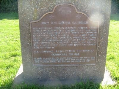
Pan American World Airways fabled China Clipper (Martin M/130 Flying Boat) left Alameda Marina on November 22, 1935. Under the command of Captain Edwin G. Musick. The flight would reach Manila via Honolulu, Midway, Wake, and Guam. The inauguration . . . — — Map (db m100565) HM
The Berkeley City Club, organized in 1927, was one of the area’s earliest attempts by women to social, civic and cultural progress. The building, constructed in 1929, is one of the outstanding works of noted California architect Julia Morgan, . . . — — Map (db m100562) HM
This site was part of the original Don Castro Land Grant. In 1866 pioneer settler Josiah Grover Brickell made a land grant of this site for “educational purposes only” and paid the teacher’s salary, who taught children by day, in a one . . . — — Map (db m100557) HM
At the Ohlone Indian village of Oroysom, Padre Fermín Francisco de Lasuén founded this fourteenth of twenty-one Franciscan missions June 11, 1797. Taught by Padre Narciso Durán, the Ohlone Orchestra and Choir became famous. By 1830 almost 2,000 . . . — — Map (db m100551) HM
Site of flour mill, Niles. Built 1853 by Don Jose De Vallejo, brother of General Vallejo, on his Rancho Arroyo De La Alameda.
Niles was once called "Vallejo Mills". Stone aqueduct carrying water for mill parallels Niles Canyon Road. — — Map (db m154369) HM
This winery was founded in 1869 by Leland Stanford, railroad builder, Governor of California, United States Senator, and founder of Stanford University. The vineyard, planted by his brother Josiah Stanford, helped to prove that wines equal to any in . . . — — Map (db m100554) HM
Here, in 1883, James Concannon founded the Concannon Vineyard. The quality it achieved in sacramental and commercial wines helped establish Livermore Valley as one of America’s select wine growing districts. Grape cuttings from this vineyard were . . . — — Map (db m100553) HM
Here, Charles A. Wetmore planted his vineyard in 1882. The Cresta Blanca wine he made from its fruit won for California the first international award, the highest honor at the 1889 Paris Exposition, first bringing assurance to California wine . . . — — Map (db m100552) HM
Here the first Wente Vineyards of 47 acres was established by C.H. Wente in 1883. In 1935 his sons, Ernest and Herman, introduced California’s first varietal wine label, Sauvignon Blanc. The efforts of the Wente family have helped to establish the . . . — — Map (db m100563) HM
The naming of the Rainbow Trout species was based on fish taken from the San Leandro Creek drainage. In 1855, Dr. W.P. Gibbons, founder of the California Academy of Sciences, was given three specimens obtained from the creek. He described and . . . — — Map (db m100566) HM
Until at least 1851, Redwood trees on this site were used as landmarks to avoid striking the treacherous submerged Blossom Rock in San Francisco Bay west of Yerba Buena Island. Although by 1855 the original stems had been logged, today's trees are . . . — — Map (db m100564) HM
Designed in 1889 by Walter J. Mathews, this solid masonry Romanesque church departed radically from California's traditional Gothic wood frame construction. Noted for its world famous stained glass windows produced by Goodhue of Boston, and for . . . — — Map (db m100561) HM
This is a superior rendering of the "Art Deco" or "Moderne" style of movie palace built during the rise of the motion picture industry. The Paramount, which opened on December 16, 1931, is the most ambitious theatre design of architect Timothy L. . . . — — Map (db m100560) HM
University of California, chartered March 23, 1868. Located between Franklin and Harrison, 12th and 14th Streets, from 1869 to 1873, using buildings of former College of California, successor to Contra Costa Academy founded by Henry Durant, June . . . — — Map (db m100544) HM
First brick house built in Alameda County. Constructed 1860 by W. R. Toler for Ignacio Peralta, early San Leandro Spanish settler, whose father, Don Luis Maria Peralta, received land grant from Spanish Governor Don Pablo Vicente de Sola, October 20, . . . — — Map (db m100550) HM
Governor Pablo de Solá, last Spanish Governor of California, awarded the San Antonio Grant to Don Luis Maria Peralta on August 13, 1820, in recognition of forty years of service. From this point northward the Grant embraced over 43,000 acres. Now . . . — — Map (db m100548) HM
Site of the last home of José Joaquin Estudillo, grantee of Rancho San Leandro and his wife, Juana Martínez de Estudillo. It was built about 1850. The family founded San Leandro, built a hotel, and donated several lots, including the original site . . . — — Map (db m100549) HM
The first court house where Alameda County government began, June 6, 1853. Officials met in two-story wooden building erected by Henry C. Smith and A. M. Church as merchandise store. Seat of government moved to San Leandro in 1856 following vote of . . . — — Map (db m28910) HM
The factory was built in 1870 by E. H. Dyer, “Father of the American Beet Sugar Industry.” Located on a corner of Dyer’s farm, the small factory began processing sugarbeets on November 15, 1870, and produced 293 tons of sugar during its . . . — — Map (db m100556) HM
Here the Old Emigrant Road of 1848 swung down across the meadow now covered by Caples Lake (Twin Lakes) and climbed along the ridge at the right to the gap at the head of the valley. From this summit (9,460 feet) it descended to Placerville. This . . . — — Map (db m100570) HM
Settled by Missourians 1849. Suggested that settlement be called Fiddletown because residents “were always fiddling”. Changed in 1878 to Oleta but original name later restored. Once trading center for American, Loafer, and French Flats, . . . — — Map (db m100577) HM
General merchandise store built by Daniel Stewart in 1856. First brick building erected in Ione Valley from nearby Muletown brick. Ione, once known as "Bed-Bug" and "Freeze-Out” was an important supply center on the main road to the Mother Lode and . . . — — Map (db m100587) HM
The cornerstone was laid in 1862. Constructed of locally fired brick, the church was completed in 1866. Dedicated as “Ione City Centenary Church” and later popularly known as the “Cathedral of the Mother Lode.” The church was the first to serve the . . . — — Map (db m241817) HM
The “castle,” built in 1890–1894, is the most significant example of Romanesque Revival architecture in the Mother Lode. It was built to house the Preston School of Industry, established by the State Legislature as a progressive . . . — — Map (db m100594) HM
Argonaut Mine, discovered 1850, and Kennedy Mine, discovered 1856, played dramatic roles in the economic development of California. They produced $105,268,760 in gold. Kennedy Mine has a vertical shaft of 5,912 feet, the deepest in the United . . . — — Map (db m100586) HM
On September 18, 1857, Congregation B’nai Israel of Jackson dedicated on this site the first synagogue in the Mother Lode. High holiday worship continued until 1869 when the larger Masonic Hall was used to accommodate the congregation. The wooden . . . — — Map (db m100588) HM
D’Agostini Winery was started in 1856 by Adam Uhlinger, a Swiss immigrant. The original wine cellar, with walls made from rock quarried from nearby hills, hand hewn beams, and oak casks, is still in use and part of the present winery. Some original . . . — — Map (db m100585) HM
Knight Foundry was established in 1873 to supply heavy equipment and repair facilities to the gold mines and timber industry of the Mother Lode. Samuel N. Knight developed a high speed, cast iron water wheel which was a forerunner of the Pelton . . . — — Map (db m100590) HM
Here in Volcano in 1860, miner and amateur astronomer George Madeira built California's first astronomical observatory of record and operated it for two years. Using a three inch refractory telescope he studied sun and moon, stars and planets, and . . . — — Map (db m100583) HM
On the knoll behind this marker, George Madiera built the first amateur astronomical observatory of record in California and there discovered the great comet of 1861 with a three-inch refractor telescope. — — Map (db m100584) HM
In a village, the roundhouse served as the center of ceremonial and social life. Constructed in 1974, the Chaw Sé roundhouse continues this tradition. With its door facing the east, towards the rising sun, four large oaks are the focal point of this . . . — — Map (db m8720) HM
[Larger Marker]:
Started 1848 by soldiers of Colonel Stevenson’s Regiment. Named by miners because of apparent volcanic appearance. Here the first California rental library, 1850, was established. And one of the first “Little . . . — — Map (db m100574) HM
In 1888, the State Board of Forestry established an experimental forestry station and nursery, a companion to the Santa Monica Station established in 1887. The two were the first such stations in the nation. Exotic and native trees were tested and . . . — — Map (db m100602) HM
A vast expanse covering 26,000 acres, Rancho Chico was purchased in 1849-50 by John Bidwell. In 1865 he began construction of the mansion nearby, which in time became the social and cultural center of the upper Sacramento Valley. It was through his . . . — — Map (db m230785) HM
Dedicated in the spring of 1863, this building served as a temple of worship for 10,000 Chinese then living here. Funds for its erection and furnishings were provided by the Emperor and Empress of China and local Chinese labor built the structure. . . . — — Map (db m100599) HM
Judge Joseph Lewis planted this Mediterranean Sweet Orange seedling near the toll bridge at Bidwell’s Bar, Butte County, California in 1856. It has survived hard times and is the oldest living orange tree in California. “From its example and . . . — — Map (db m143395) HM
Entering California over the Applegate and Lassen trails, a party of Oregonians, captained by Peter H. Burnett, arrived here in autumn of 1848 to establish the town of Oregon City. Burnett, little more than a year later, became the first civil . . . — — Map (db m100600) HM
For thousands of years the Yahi Indians roamed the foothills between Mt. Lassen and the Sacramento Valley. Settlement of this region by the white man brought death to the Yahi by gun, by disease, and by hunger. By the turn of the century only a few . . . — — Map (db m100601) HM
This brick building, erected in 1858 with funds raised by a dance in the Billiard Saloon of the N.R. Prince Building (which still stands), is one of the oldest schools of California. Used as a school until 1950, it was then replaced by the present . . . — — Map (db m10143) HM
This structure was erected in 1852 by B. R. Prince and G. Garibardi for a general merchandise business. Improved in 1857 with living quarters on the second floor, it is still used for living and warehouse purposes. — — Map (db m11047) HM
C.C. Lake erected here a canvas hotel in 1851. It was replaced by a one-story wooden structure, and then by one of stone in 1855, with second story being added in 1857. Here, Samuel Clemens first heard the yarn, which was later to bring him fame as . . . — — Map (db m17664) HM
Gold discovered in creek just below town by James H. Carson in 1848, whose name was given to creek, hill and town. In November, 1854, at Morgan Mine, was found the largest gold nugget in California, weighing 195 pounds troy, worth at that time . . . — — Map (db m6848) HM
In 1848 John W. Robinson and Stephen Mead established ferry transport for freight, animals and persons across river. In 1856 Harvey Wood purchased interest and later acquired property which was maintained by Wood family until 1911. Charges were 50 . . . — — Map (db m6845) HM
[Upper Marker:]
Named Camanche in 1849 after Camanche, Iowa. Once called Limerick. Peak population 1500. Rich mining at nearby Cat Camp, Poverty Bar, and Sand Hill. Mokelumne River water brought in by Lancha Plana and Poverty Bar ditch. . . . — — Map (db m19752) HM
Calaveritas, settled in 1849 by Mexicans, was a flourishing mining town complete with stores, saloons, gambling houses, and fandango halls. Joaquin Murieta is reported to have frequently visited its Fandango Halls and gambling houses. Destroyed by . . . — — Map (db m12992) HM
Settled in 1849 by Mexicans who worked placers in Oregon Gulch. Rich copper deposits discovered in 1859. The largest living cork oak tree in California was planted here in 1858. Ruins of Adams Express Building still standing. — — Map (db m10629) HM
Copper here discovered by W. K. Reed and Thomas McCarty in 1860. Mines utilized during the Civil War and the First and Second World Wars. During Civil War period was the principal copper producing section of the United States. — — Map (db m13002) HM
A portion of this building served as the Calaveras County Courthouse from 1852 to 1866, when the county seat was removed to San Andreas. George W. Leger then acquired the court building and made it a part of his adjoining hotel, which has been . . . — — Map (db m11537) HM
Richest placer mining section, extending five miles, in Calaveras County. Received name from Chileans who worked gulch in 1848 and 1849, and scene of the so-called Chilean War. Largest known quartz crystals recovered from mine on south side of gulch. — — Map (db m11515) HM
James L. Sperry and John Perry opened the Sperry and Perry Hotel August 20, 1856. In 1881 Henry Atwood and then Harvey Blood owned it. In 1882, the Mitchler family renamed it the Mitchler Hotel. In 1945, the McKimins’ changed its name to Murphys . . . — — Map (db m2612) HM
Constructed by Peter L. Traver in 1856, this is the oldest stone building in Murphys. Its iron shutters and sand on the roof protected it from the fires of 1859, 1874, and 1893. It served as a general store, a Wells Fargo office, and later a garage. — — Map (db m2611) HM
A thriving mining camp on rich Pennsylvania Gulch in the 1850’s and 1860’s. Named for Alfred Brown, former owner of Table Mountain Ranch. Laws of Brownsville Mining District provided that each miner could own one wet and one dry claim, not to exceed . . . — — Map (db m11501) HM
Founded February 18, 1850. Became county seat of Calaveras County. Old court house, said to be constructed of lumber brought from China, is still standing but not on the original site. — — Map (db m152282) HM
Located on the Stockton-Murphy Road at the fourth crossing of the Calaveras River, this early mining settlement, once called Foremans, was famous in the 1850's for its rich placer ores. Later, it became an important stage and freighting depot and . . . — — Map (db m11969) HM
Founded February 18, 1850. Became county seat of Calaveras County. Old court house, said to be constructed of lumber brought from China, is still standing but not on the original site. — — Map (db m149318) HM
Gwin Mine, Paloma, and Lower Rich Gulch were mined for placer in 1849. Quartz was discovered by J. Alexander in 1851. Property acquired by Wm. M. Gwin, California's first U.S. Senator, in 1851. The Gwin Mine closed, in 1908, yielded millions. — — Map (db m14449) HM
Named by famous scout Kit Carson while searching for pass over Sierras. One emigrant road forked at Big Meadows, and north branch came directly to West Point. A thriving trading post prior to gold discovery. Bret Harte, famous author, lived here for . . . — — Map (db m44371) HM
Erected in 1861, this Federal/Classic Revival style building is the oldest remaining courthouse in the Sacramento Valley. The “Southern” style reflects the county’s heritage from the Ante-Bellum South and states-rights sympathies during . . . — — Map (db m57626) HM
From 1860 to 1906, this area was the largest coal mining district in California. Five towns (Nortonville, Somersville, Stewartville, Judsonville and West Hartley) grew up around twelve major mines. Today the towns are gone. The buildings having been . . . — — Map (db m139449) HM
This was the first American home in Crockett. Constructed in 1867 by Thomas Edwards, Sr., on land purchased in 1866 from Judge J.B. Crockett. Located on an earlier Indian village near the Carquinez Straits, its timbers, some of which were brought . . . — — Map (db m12153) HM
Mount Diablo, sacred to Native Americans who lived and worshipped there for over 5,000 years became a critical reference point for Spanish explorers in the 18th century, and American trappers and early California settlers in the 19th. In 1851 . . . — — Map (db m17541) HM
Ranch home of John Muir 1838- 1914, explorer, naturalist, author and foremost advocate of forest protection and of national parks. The John Muir Trail through the High Sierra, Muir Woods National Monument and Muir Glacier in Alaska are named for . . . — — Map (db m51132) HM
In 1849, Vicente Martinez built a two-story adobe ranch house on his portion of the Rancho Pinole. This land was inherited from his father, Don Ignacio Martinez, a Spanish officer who became Comandante of the San Francisco Presidio and later Alcade . . . — — Map (db m50821) HM
Pt. Pinole is the last site of the Giant Powder Company, the first company in America to produce dynamite. Following devastating explosions at their San Francisco and Berkeley sites, the business moved to this isolated location in 1892. . . . — — Map (db m143396) HM
The Battery Point Lighthouse is one of the first lighthouses on the California Coast.
Rugged mountains and unbridged rivers meant coastal travel was essential for the economic survival of this region.
In 1855 Congress appropriated $15,000 for . . . — — Map (db m101692) HM
This memorial is dedicated to those who lost their lives in the wreck of the Pacific Mail Steamer, Brother Jonathan, at point St. George's Reef, July 30, 1865. — — Map (db m76459) HM
Here in the Valley of the Cul-lum-mah Indians, James W. Marshall discovered gold on January 24, 1848, in the tailrace of Sutter’s sawmill. The Old Coloma Road, opened in 1847 from Sutter’s Fort to Coloma, was used by Marshall to carry the news of . . . — — Map (db m12272) HM
This town, settled in 1848, derived its name from its crystal clear springs. Among the richest in this vicinity its diggings produced a 25 pound nugget, one of the largest in El Dorado County. Its most thriving period was in 1851. Later it became a . . . — — Map (db m10936) HM
El Dorado, meaning “The Gilded One”, was first known as Mud Springs from the boggy quagmire the cattle and horses made of a nearby watering place.
Originally a important camp along the old Carson Emigrant Trail. By 1849 – 50 it . . . — — Map (db m13148) HM
Trading post, emigrant stop, and mining camp of the 1850’s. This became one of the remount stations of the Central Overland Pony Express. Here at the Nevada House on April 13, 1860, pony rider William (Sam) Hamilton changed horses while carrying . . . — — Map (db m11571) HM
At this site on the old Clarksville-White Rock Emigrant Road was Mormon Tavern. Constructed in 1849, this popular stage stop was enlarged and operated by Franklin Winchell in 1851. It became a remount station of the Central Overland Pony Express and . . . — — Map (db m12056) HM
Founded August 7, 1849 by George Phipps and party. Nicknamed Growlersburg from the heavy nuggets that “growled” in the miners’ pans. Georgetown was the hub of an immensely rich gold area. After the disastrous fire of 1852 the old town . . . — — Map (db m57962) HM
John Greenwood, a trapper and guide who came to California in 1844, established a here a trading post in 1849. The mining town of Greenwood, which developed during the Gold Rush, boasted a theater, 4 hotels, 14 stores, a brewery, and 4 saloons. . . . — — Map (db m10447) HM
Site of the only tea and silk farm established in California. First agricultural settlement of pioneer Japanese immigrants who arrived at Gold Hill on June 8, 1869. Despite the initial success, it failed to prosper. It marked the beginning of . . . — — Map (db m76181) HM
This was the site of a change station of the Pioneer Stage Company in the 1850’s and 1860’s. During 1860-1861, the Central Overland Pony Express maintained here the first pony remount station east of Sportsman’s Hall. — — Map (db m57977) HM
This was the site of Webster's Sugar Loaf House, well-known stopping place during the Comstock rush. Beginning in April 1860, it was used as a remount station of the Central Overland Pony Express. In 1861 it became a horse change station for . . . — — Map (db m14177) HM
This was the site of the most eastern remount station of the Central Overland Pony Express in California. Established as a trading post in 1851 by Martin Smith, it became a popular hostelry and stage-stop operated by Ephraim “Yank” Clement on the . . . — — Map (db m433) HM
Original Marker - Missing
First Replacement Marker - See Photo #2
Pilot Hill Grange No.1, of 29 charter members: Master, F. D. Brown; Secretary, A. J. Bayley; was organized August 10, 1870. The Grange Hall, dedicated at this site . . . — — Map (db m11607) HM
Established on banks of “Hangtown” Creek as rich mining camp in spring of 1848. Millions in gold were taken from its ravines and hills. Supply center for surrounding mining camps and transportation terminus for famous Comstock Lode. John M. . . . — — Map (db m12732) HM
Gold Rush town and Western Terminus of the Placerville – Carson Road to the Comstock. Placerville was a relay station of the Central Overland Pony Express, April 4, 1860 – June 30, 1861. Here on April 4, 1860 the first east-bound pony . . . — — Map (db m57973) HM
This was the site of Sportsman’s Hall, also known as Twelve-Mile House. The hotel operated in the late 1850’s and 1860’s by John and James Blair, a stopping place for stages and teams of the comstock. It became a relay station of the Central . . . — — Map (db m609) HM
Past this point on the Old Coloma Road, running between Sutter’s Fort and his sawmill on the American River, James W. Marshall rode with the first gold discovered at Coloma on Jan. 24, 1848. Traveled by thousands to and from the diggings, this road . . . — — Map (db m11268) HM
On this site the Boston-Newton Joint Stock Association encamped on September 26, 1849. The company left Boston April 16 and arrived at Sutter’s Fort September 27. After a remarkable journey across the continent a rich store of written records . . . — — Map (db m11568) HM
This was the site of a popular roadhouse, where the ponies of the Central Overland Pony Express were changed during July 1, 1860 to June 30, 1861. From here the route of the pony riders continued westward to Folsom and eastward through Rescue, Dry . . . — — Map (db m10442) HM
In 1968, Echo Summit served as a high-altitude training center and site of the U.S. Olympic Men's Track and Field Trials. Four world records were shattered here on the track carved out of the El Dorado National Forest. The U.S. team selected for the . . . — — Map (db m89152) HM
This popular resort and stopping place for stages and teams of the Comstock, established by Swift and Watson in 1856, became a remount station of the Central Overland Pony Express on April 4, 1860. Here on that date division superintendent Bolivar . . . — — Map (db m436) HM
Headquarters of notorious bandit Joaquin Murieta. Killed here July 25, 1853 by posse of state rangers led by Captain Harry Love. Terrorized mining camps and stage operations during his career. — — Map (db m151585) HM
Headquarters of notorious bandit, Joaquin Murieta. Killed here July 25, 1853, by posse of State Rangers, led by Captain Harry Love. Terrorized mining camps and stage operations during his career. — — Map (db m229467) HM
Here, beneath the hot, arid surface of the San Joaquin Valley, Baldasare Forestiere (1879-1946) began in the early 1900's to sculpt a fantastic retreat. Excavating the hardpan by hand, he created a unique complex of underground rooms, passages and . . . — — Map (db m41003) HM
This memorial is dedicated to over 5,000 Americans of Japanese ancestry who were confined at the Fresno Fairgrounds from May to October 1942. This was an early phase of the mass incarceration of over 120,000 Japanese Americans during World War II . . . — — Map (db m165490) HM
By the early 1850's, newly arrived white settlers had moved into the Humboldt Bay area, causing conflict with the native inhabitants. To protect both Indians and settlers, Fort Humboldt was established in 1853 and operated until 1866. It became a . . . — — Map (db m19936) HM
Captain Jonathan Winship made the first recorded entry into Humboldt Bay by sea in June 1806. Encountered in 1849 by Josiah Gregg’s party. New word of its existence reached San Francisco. By 1850 the Laura Virginia Association had founded Humboldt . . . — — Map (db m1555) HM
This pioneer agricultural community, settled in 1852, helped feed the booming population of mid-century San Francisco. Long known as “Cream City,” Ferndale made innovative and lasting contributions to the dairy industry. Local creameries, and the . . . — — Map (db m1557) HM
California's first drilled oil wells producing crude to be refined and sold commercially were located on the north fork of the Mattole River approximately three miles east of here. The old Union Mattole Oil Company made its first shipment of oil . . . — — Map (db m51955) HM
Founded April 8, 1850, Trinidad is the oldest town on the Northern California coast. During the 1850s, it served as a vital supply link between ships anchored at Trinidad Bay and miners in the Klamath, Trinity, Salmon River, and Gold Bluff mines. It . . . — — Map (db m1188) HM
Directly below was located the ancient Yurok village of Tsurai. A prehistoric, permanent Indian community, it was first located and described by Captains Bodega and Heceta, June 9-19, 1775. The houses were of hand-split redwood planks, designed for . . . — — Map (db m1189) HM
Here on September 23, 1849, Lieut. Cave J. Couts, Escort Commander, International Boundary Commission, established Camp Salvation. From September till the first of December 1849, it served as a refugee center for distressed emigrants attempting to . . . — — Map (db m50586) HM
Known as Santa Rosa De Las Lajas (Flat Rocks), this site was used on March 8, 1774 by the Anza exploring expedition, opening the land route from Sonora, Mexico, to Alta California. On December 11 to 15, 1775 the three divisions of Anza's colonizing . . . — — Map (db m62074) HM
Camp Pilot Knob was a unit of the Desert Training Center, established by General George S. Patton Jr., to prepare American troops for battle during World War II. It was the largest military training ground ever to exist. At the peak of activity here . . . — — Map (db m50590) HM
Prolific author Harold Bell Wright purchased 160 acres here in 1907. While living in a tent he built Rancho El Tecolote, constructing a woven arrow weed studio in 1908 and a ranch house in 1909. From 1907 to 1916 he wrote three best sellers, . . . — — Map (db m62032) HM
600 entries matched your criteria. The first 100 are listed above. Next 100 ⊳