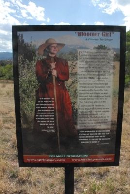
In 1858, a young woman from Kansas climbed to the summit of Pikes Peak. Julia Archibald Holmes was the first Anglo woman on record to make the climb, and she became famous for that accomplishment as well as for the way she did it.
Julia had arrived . . . — — Map (db m46001) HM
Welcome!
Rock ledge Ranch Historic Site is a living history museum that allows visitors to experience the lives of the people who dwelled, worked, hunted, herded and raised families here from the 1700s to the early 20th century. This . . . — — Map (db m46002) HM
1775-1835 American Indian Area
Discover the history and culture of the American Indians who lived in the Central Front Range of the Rocky Mountains. Visitors will have an opportunity to see an elk or buffalo hide tepee, a wide variety of . . . — — Map (db m135562) HM
The Central Garden Trail is a moderate, one-mile round-trip loop. It is paved and wheelchair accessible. This trail will take you between the towering Gateway Rocks into the heart of Garden of the Gods Park. Along the way you will have the . . . — — Map (db m72936) HM
This tablet is the
property of the State of Colorado
_____
Due south 610 feet is the
Old Stone Fort
built at the pioneer home of
David McShane. Constructed as a
defense against Arapaho and . . . — — Map (db m104869) HM
The first Anglo explorers journeyed th[r]ough this area in the early-to-mid-1800s. The Homestead Act of 1862 opened the land to pioneers to select a 160-acre parcel to establish a dwelling and start their adventure in the west. First pioneers on . . . — — Map (db m158304) HM
Frontier Communication.
Kiowa was originally named after its postmaster, Henry Wendling. Such identifications were common among Colorado’s frontier hamlets, where the post office often was the town. Widely dispersed settlers would congregate . . . — — Map (db m45754) HM
Trail Under Siege Indians of Colorado’s High Plains
Kiowa and Comanche Indians migrated to these prairies in the 1700s, followed by Cheyennes and Arapahos in the early 1800s. The region’s vast grasslands, thick bison herds, and brisk fur . . . — — Map (db m45756) HM
During the late 18th century and early 19th century, Cañon City prospered as a trade and transportation center serving the agriculture and mining industries of the region. From its earliest days, Cañon City attracted visitors to soak in warm . . . — — Map (db m153316) HM
Cañon City
During the late 18th and early 19th Century, Cañon City prospered as a trade and transportation center serving the agriculture and mining industries of the region. From its earliest days, Cañon City attracted visitors to soak in warm . . . — — Map (db m56132) HM
The Ute Indians inhabited this region long before European explorers set foot on this continent. Other tribes like the Cheyenne, Arapaho, Kiowa, and the Comanche moved through the area following herds of buffalo. The Utes left traces of their . . . — — Map (db m153077) HM
This Memorial is the
Property of the State of Colorado
Built in 1860 by Anson and Harriet Rudd, the cabin is one of the few original log cabin homes still standing in Colorado. First local building with a wooden floor, this . . . — — Map (db m232229) HM
Drive the Gold Belt Tour National Scenic Byway and follow the historic travel routes to the Cripple Creek Mining District, one of the world's wealthiest gold mining districts. Phantom Canyon Road follows the grade of the Florence and Cripple Creek . . . — — Map (db m153320) HM
"Set up for yourself roadmarks...the way by which you went. Return, O virgin of Israel" Jeremiah 31:21
Nearly 70 Jewish immigrants were settled in and near Cotopaxi. Facing insurmountable challenges, the ill equipped . . . — — Map (db m134127) HM
[Left panel]
Florence
A historic Colorado oil town
Enjoy your visit
Caption:
[Center panel]
In 1859, Jesse Frazer fashioned a plow from a large cottonwood branch and planted his fields in the broad fertile . . . — — Map (db m153163) HM
Beginning in the 1870's Italians came in great numbers to Colorado. The Roaring Fork Valley's Italian immigrants performed the hard, dirty work wanted by no one else. Most were coal miners who worked the mines at Sunlight, Spring Gulch and . . . — — Map (db m120548) HM
Glenwood's Oldest Established Cemetery
Linwood Cemetery is Glenwood Springs' oldest existing cemetery and is known by several other names; Pioneer, Hill, Glenwood and Doc Holiday's. The name Linwood has been used since the cemetery's . . . — — Map (db m191017) HM
What is a Potter's Field?
As you stand in the central plaza of Linwood Cemetery, the path ahead to the east takes you to the Potter's Field section of Glenwood Springs' oldest established burial ground. A Potter's Field is the section of a . . . — — Map (db m191234) HM
This site - Lot 9 Block 45 - housed what in later years would be known as the Rex Hotel. Glenwood Springs founder Isaac Cooper first owned the property, but between 1887 to 1892, ownership changed hands several times. During this time, several small . . . — — Map (db m120082) HM
Rifle
During the U.S. Geological Survey of 1876, A.C. Peale wrote the word "rifle" on his map to mark the location of a misplaced firearm. The gun was never found, but the name stuck. Founded in 1882, Rifle attracted a steady flow of . . . — — Map (db m120749) HM
Gilpin County, Colorado
Black Hawk History
Take an adventure in & around this venerable, most informative lithograph:
This bird’s-eye view of Black Hawk shows Gregory Gulch at the top of the map’s center – and Chase Gulch to the right . . . — — Map (db m51885) HM
On this site stood the Colorado Central Railroad’s “Quartz Mill Depot”. The structure was constructed by William Loveland from the remnants of the New York Mill. To accomplish this, large doors were built into the building. The tracks, . . . — — Map (db m93084) HM
[Three panels on this marker describe the history of Central City, Colorado]
[Panel 1]
Heritage Tourism
Central City is a hidden gem set high in the mountains above the thriving front range hustle and bustle. A trip to Central . . . — — Map (db m51828) HM
Vacationers driving wagons and Model T Ford's rumbled up this road in the 1920s to spend a week or more at Sophie and John Holzswarth's Trout Lodge. After each day's fishing, guests strolled to the "Mama" Cabin-the largest building to the left where . . . — — Map (db m162341) HM
One of the Kawuneeche Valley's first dude ranches once thrived here. In 1917, German immigrants Sophia and John G. Holzwarth built their homestead here, after wartime prohibition closed their saloon in Denver. Originally ranchers, they began hosting . . . — — Map (db m162343) HM
In 1881 James Cairns built his first store here to serve the miners. In 1908 he replaced it with a better building, purchased by Matilda Humphrey in 1924. It survives as the central part of the Humphrey store. The small residence was Cairns interim . . . — — Map (db m129850) HM
Ezra Kauffman first came to the area as a hunting guide and miner in 1877. After the mines closed, he raised his family in the community he loved. He completed this hotel in 1892 and operated it until his death in 1920. The Kauffman family . . . — — Map (db m129856) HM
In 1882 P.H. Smith settled in Grand Lake. He built a hotel and also operated a sawmill, carpentry shop, and a large resort. Around 1915, along with the Alfred Eslick family, he built this Motor Court, designed to accommodate both visitors and their . . . — — Map (db m129857) HM
The Smith Eslick Family (panel 1)
Entrepreneur P.H. Smith brought his family to Grand County from Kansas. In 1893 he started a sawmill in Grand Lake and acquired several local properties.
A skillful craftsman, P.H. Smith built many . . . — — Map (db m129880) HM
This miner's cabin is one of the oldest buildings left standing in the Kawuneeche Valley. In 1902, Joseph Fleshuts homesteaded 160 acres here with the intent to live on the land for at least five years. Life must have been hard. In 1911 he abruptly . . . — — Map (db m89117) HM
[Clockwise from top right]
Glenwood Canyon. In 1993 the Colorado Department of Transportation completed the final link of Interstate 70 through this remarkable canyon.
Glenwood's Natural Hot Springs have soothed and healed human ailments . . . — — Map (db m158790) HM
"If I get through it will be a triumph-
but I must try at least and try I shall."
John W. Gunnison, 1853
1853 Gunnison Railroad Expedition
In 1853 Capt. John W. Gunnison (1812-1853) led a survey party through the Central Rockies . . . — — Map (db m158720) HM
The Coal Miners
Crested Butte's early miners were mostly Anglo-Saxons from Cornwall, Wales, Scotland, and Ireland. This changed in the 1890s when the mines were worked by cheap labor drawn from southern Europe—Slavs, Greeks, and . . . — — Map (db m158787) HM
Even before this area was protected as a national recreation area, anglers came to this stretch of the Gunnison River in search of the legendary trout. Guest ranches and fishing resorts lined the river prior to the construction of Blue Mesa . . . — — Map (db m158551) HM
Before there was a reservoir here, three towns existed along the banks of the Gunnison River. The Denver & Rio Grande Railroad hauled both freight and passengers to the towns of Iola, Cebolla, and Sapinero. Sightseers came for the Rocky Mountain . . . — — Map (db m158858) HM
Before there was a reservoir here, three towns existed along the banks of the Gunnison River. The Denver & Rio Grande Railroad hauled both freight and passengers to the towns of Iola, Cebolla, and Sapinero. Sightseers came for the Rocky Mountain . . . — — Map (db m158865) HM
Here, in the shadow of the Spanish Peaks and the Wet Mountains, stands El Huerfano - "the orphan." This stark and lonely volcanic outcrop, named in the late 1700s by an unknown Spanish trader, had for centuries guided earlier Hispanos and . . . — — Map (db m97717) HM
Dating from 1878, when Leadville butcher Reid Mathews used
the valley's abundant grass to fatten his cattle during the
summer, ranching is the oldest continuous industry in North
Park. Many other cattlemen followed, drawn to the area in . . . — — Map (db m240751) HM
Rumors of the existence of precious metals in North Park
began when John C. Fremont's expedition passed through
the valley in 1844. However, it was nearly thirty years later
that prospecting took place in North Park. Canadian James
O. . . . — — Map (db m240743) HM
As mines expanded and North Park's
population swelled, there was an increasing
need for timber to shore up the mines and
to build homes for settlers. The abundant
forests surrounding North Park afforded a
ready supply of timber, and logging . . . — — Map (db m240737) HM
In this immediate area once stood
Arapahoe City
A pioneer placer mining camp the earliest town in Jefferson County. Named for the Arapaho Indians. Town company organized Nov. 29, 1858. From here went George A. Jackson and John H. Gregory . . . — — Map (db m82878) HM
David King Wall, one of Golden’s early permanent settlers, arrived from South Bend, Indiana on April 30, 1859. He brought a great deal of garden seed and tools with him. King defied the common belief that growing a garden would be impossible due to . . . — — Map (db m50595) HM
From the beginning, Clear Creek has determined the layout of the town first known as “Golden City.” Golden is placed at an angle from the compass to align its streets to the river. The first river crossing also determined the location of . . . — — Map (db m49903) HM
In June, 1859, while the first bridge was being built over Clear Creek, the famous reporter Horace Greeley passed through Golden. He attempted to cross Clear Creek from this point on the south bank. Horace embarked on his mule from the river bank . . . — — Map (db m49898) HM
Before the first bridge on this site was completed, travelers forded the river just east of this bridge. It became risky during the peak of the spring river flows due to the melting snows that filled the streams and rivers.
In June of 1859, . . . — — Map (db m50179) HM
In the 1700s French trading parties came to trade with the Utes. Around 1820 Americans such as the Long Expedition began to explore the Clear Creek valley. In 1834 the Estes Party discovered gold on a sand bar, later known as Arapahoe Bar, on the . . . — — Map (db m50600) HM
Seven members of the Boston Mechanics’ Mining & Trading Company, namely George West (President), Walter Pollard, James MacDonald (Business manager), Mark Leonardo Blunt (later Postmaster), James McIntyre, Lawrence Panton, and Joseph T. Bird arrived . . . — — Map (db m50180) HM
Devoted family man and visionary businessman.
John Brisben Walker is personally responsible for the way much of the front range looks in this area. In his quest for the perfect place to build a home for his family, he preserved thousands . . . — — Map (db m141095) HM
Sand Creek Massacre
National Historic Site
Sand Creek Massacre National Historic Site memorializes the massacre of nearly two hundred Cheyenne and Arapaho Indians.
Near dawn on November 29, 1864, detachments of the 1st . . . — — Map (db m107179) HM
Calvary Presbyterian Church of Pine River
89 E. Mill Street
Ground was broken for the foundation of the church on April 16, 1898; the building was first used for services eleven months later, on March 15, 1899. The lots were donated by W. . . . — — Map (db m160512) HM
In January of 1914, L. E. Jenkins bought the lot at the corner of Mill and Pearl Streets. In February he started construction on this building and hired J. M. Lail as his contractor. According to the Bayfield Blade, L. E. Jenkins was in his new . . . — — Map (db m160497) HM
H.C. Schroder bought [this] property at the end of 1899 and by 1900-1901 he had constructed a flour mill and a retail store on the property; it is likely that he built this house at the same time. The Beach family owned this house from June 1925 . . . — — Map (db m160496) HM
Hotel Central
57 W. Mill Street
The August 3, 1911 edition of the Bayfield Blade reported the completion of the "Hotel Central." This photo shows the building originally had wood clapboard siding, a wood shingle roof, and a covered . . . — — Map (db m160490) HM
Schroder Store
64 W. Mill Street
(Second from left)
The November 7, 1901 Durango Democrat reported that H. C. "Schroeder" was building a new storehouse in Bayfield; this is the west half of this building. Between 1910 and 1919, additions . . . — — Map (db m160471) HM
A majority of the buildings visible in this photo were destroyed in the fire of 1889. The nearest block featured a wide variety of businesses, including the Grand Central Livery, the building on the right. A look down Main shows smelter smoke . . . — — Map (db m160299) HM
The large building in the foreground is Durango's first high school. Above it is the new La Plata County Courthouse. The Boulevard, today's Third Avenue, is the street running between the two. The Ladies' Literary Society planted trees in the . . . — — Map (db m160451) HM
Built in 1892 by Senator Charles Newman, pioneer merchant, miner and legislator. He maintained his office here until his death in 1906.
Major Daniel L. Sheets, cattleman and member of Colorado’s second state legislature, operated the U.S. Land . . . — — Map (db m51814) HM
This place has seen plenty of changes since Charles Senter discovered a deposit of molybdenum on Bartlett Mountain in 1879.
In the early days, Climax was a sleepy depot at the top of a railroad grade. But by World War I there was a . . . — — Map (db m122841) HM
It's only a memory now, but the community of Climax was once called home by several generations of Colorado mining families.
In its early years, Climax struggled to keep quality employees. Cold and snow, isolation and high altitude sent many . . . — — Map (db m122837) HM
A whole lot of Colorado history has happened right here on top of Fremont Pass. And it all happened because of a metal most people have trouble pronouncing.
Molybdenum (moll-ib-den-um) is used to harden steel.
More molybdenite ore (the . . . — — Map (db m122900) HM
Erected 1878, by August R. Meyer, builder of Leadville’s first reduction works. Given to Leadville Association, 1936, by Nellie Healy, agent for the heirs of Daniel Healy.
Presented to the State of Colorado by said association, 1947, and . . . — — Map (db m51812) HM
Born in Virginia, Texas Jack came west after the Civil War at age 16 to become a cowboy. He later made a name for himself as a plainsman and U.S. government scout who led the Pawnee Indians on their summer hunts and was guide for such notables as . . . — — Map (db m121768) HM
Father of the Rocky Mountain National Park
internationally known naturalist, author, lecturer and nature guide
Homesteaded on this site in 1885. — — Map (db m78715) HM
Joseph Antoine Janis was born in St. Charles, Missouri, in 1824. He made a claim on the Cache la Poudre River in 1844, intending to return later to build a home. In the summer of 1859, Antoine Janis, his Oglala wife First Elk Woman and their . . . — — Map (db m105248) HM
This property, part of the original Camp Collins, was purchased by the Mosman family on October 5, 1891. In 1892 prominent architect, Momtezuma Fuller (1858-1925) designed this house, in a distinctive Eastlake Victorian Queen Anne architectural . . . — — Map (db m52324) HM
This log house was built by French trader Sam Deon in 1858. Purchased by Civil War Veteran John Wesley Tharp in 1877. From 1877-1937 the home of Eliza Bingham Tharp Gardner. From 1937-1985 the property of Ethel Gardner Ames Holtz. Now belongs to . . . — — Map (db m174426) HM
A stage station, post office, and hotel, on the route from Fort Collins, by way of Pingree Hill, to Home, Colorado, in the upper Poudre Canyon.
In memory of Mildred Payson Beatty — — Map (db m173076) HM
What a welcome sight Virginia Dale must have been to nineteenth-century travelers. It was one of the largest stagecoach stations on the Overland Trail, offering hot meals and other conveniences to weary passengers - the equivalent, for its day, of . . . — — Map (db m89639) HM
Downtown Loveland Historic District has been placed on the National Register of Historic Places by the United States Department of the Interior March 2015
The downtown Loveland historic district encompasses portions of nine square blocks . . . — — Map (db m222002) HM
This Memorial Is the
Property Of The State Of Colorado
Namaqua
Home, trading post and fort of
Mariano Modena, early trapper,
scout and pioneer.
First settlement in the
Big Thompson Valley.
Station on Overland . . . — — Map (db m51194) HM
Farmhand to Cattle Baron Eugene Rourke was born on St. Patrick's Day in 1849 in Wicklow County, Ireland. The younger of 10 children, Eugene and his
family immigrated to La Salle, Illinois in 1852. Tragically, his
parents died . . . — — Map (db m181884) HM
The Rourke Ranch Historic District, listed on the National
Register of Historic Places in 2000, is a striking example of a late
19th century cattle ranching enterprise. The ranch played a significant role in the settlement and . . . — — Map (db m181947) HM
Panel 1
Road to Santa Fe
"...for it begins upon the outside line of the outside State (Missouri) and runs directly toward the setting sun..." - Sen. Thomas Hart Benton, following the Santa Fe Trail survey, 1825
For . . . — — Map (db m97715) HM
Panel 1
The Ludlow Massacre
By April 1914, the striking coal miners encamped at Ludlow (ten miles northwest of here) had nothing to lose but their lives. Poor, powerless, largely immigrant, they had held out for . . . — — Map (db m97716) HM
This memorial is the
Property of the State of Colorado
The Santa Fe Trail
1840 - 1878
Two roads or forks of the Mountain Branch
of the Santa Fe Trail-Bent's Old Fort to
Taos and Santa Fe-joined . . . — — Map (db m104912) HM
Trinidad: A Place to Explore and
Until the 1700s, the Ute people traveled the Mountains of western Colorado, and the Apache controlled the eastern plains. The Apache gave way to the Comanche between 1720 and 1805, and the Ute extended . . . — — Map (db m188717) HM
Panel 1
Welcome to Colorado
Colorado's vast plains, rugged mountains and grand plateaus, so magnificent in their beauty and variety seem at times to overshadow the state's history and people. But look closely. The . . . — — Map (db m97739) HM
Sand Creek Massacre
At dawn on the morning of November 29 I was still in bed when I heard shouts and the noise of people running about the camp. I jumped up and ran out of my lodge. From down the creek a large body of troops was . . . — — Map (db m107245) HM
Welcome to Lincoln County, Home of Pioneer Hospitality!
With its cowboy and homesteader heritage, Lincoln County is infused with an old-time spirit of hospitality. The discovery of gold in the Colorado mountains brought large cattle . . . — — Map (db m107246) HM
Call it the Pikes Peak Trail, the Denver Road, Overland Trail, or the South Platte River Trail – by any name, it dominated the movement of people and goods in Colorado between 1858 and 1867 and ranks with the great trails of American history. . . . — — Map (db m51215) HM
This tablet is the Property of the State of Colorado
3.8 miles north along county road is the site of Valley Station, built in 1859 as a stagecoach station of the Leavenworth and Pike Express. Station on the Overland Trail to California, . . . — — Map (db m51214) HM
This tablet is erected in honor of
William Shaw Hadfield
The first white settler of Logan County, marking the site of his first sod house at Hadfield Island in 1871, three-fourths mile east.
Erected by the wife
Margaret Seibert . . . — — Map (db m61996) HM
Reportedly, in October 1899 Butch Cassidy and several members of the Wild Bunch, also known as the Hole-in-the-wall Gang, travelled through Grand Valley.
From 1889 to 1904 this band of desperadoes thrilled local citizens and terrified many . . . — — Map (db m104504) HM
A Brief History
Fruita was founded in 1884 by William E. Pabor as a fruit growing colony. Pabor's early efforts to create a commercially viable fruit industry between California and the upper Midwestern states led to the Grand Valley . . . — — Map (db m159775) HM
[center panel] Elkhead Creek drains an area to the north and east. It is 37 miles long and empties into the Yampa River a short distance to the south of this point. Elkhead Reservoir is a 25,500 acre-feet body of water, four miles north of . . . — — Map (db m166697) HM
Edwin C. Johnson served thirty four
continuous years in public service to
Colorado; Moffat and Routt County
Legislator, Lt. Governor, three times
Elected Governor and eighteen
years as a United States Senator.
In dedication
to all . . . — — Map (db m114444) HM
Canyons of the Ancients National Monument encompasses 164,000 acres of southwest Colorado. It was established on June 9, 2000, to protect the cultural and natural resources of the canyons and mesas.
For hundreds of years, the canyons and . . . — — Map (db m160230) HM
Colorado Territory was created in 1861 for its gold, silver and other mineral resources. Its western boundary was designated as 32 degrees of longitude west of the Washington Meridian.
Colorado became a state in 1876. In 1878, U.S. Surveyor . . . — — Map (db m36527) HM
Community Connections
Welcome to the Four Corners! As you explore this area and visit the National Parks, Monuments, and National Forest lands or drive on the San Juan Skyway, you will be traveling through a number of communities... . . . — — Map (db m160181) HM
In 1776 the year of our independence, a family was led by two Catholic priests, father Dominguez and Escalante. They camped in a meadow on the Dolores River which in 105 years became the town of Big Bend.
Big Bend had several saloons, a saw mill, a . . . — — Map (db m52402) HM
Sleeping Ute Mountain
Sprawling ten miles across the highlands west of here, Sleeping Ute Mountain comprises no fewer than seven separate peaks — and at least as many legends. According to one, the mountain took shape eons ago when a . . . — — Map (db m153394) HM
320 entries matched your criteria. Entries 101 through 200 are listed above. ⊲ Previous 100 — Next 100 ⊳