After filtering for California, 568 entries match your criteria. Entries 101 through 200 are listed.⊲ Previous 100 — Next 100 ⊳
Churches & Religion Topic
By Kelly J. Hobbs, February 27, 2006
Francisco Garces Statue Dedication Marker
| 101 ► California, Kern County, Bakersfield — 277 — Francisco Garces — 1738 – 1781 — Spanish Franciscan — |
| On North Chester Avenue at Golden State Highway (California Route 204), in the median on North Chester Avenue. | |||
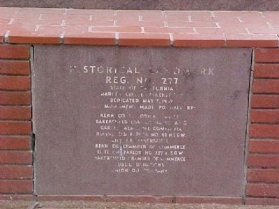
| 102 ► California, Kern County, Bakersfield — 278 — Rio de San Felipe — California Historical Landmark — |
| On Kern Canyon Road (State Highway 178), on the left when traveling east. | |||
| 103 ► California, Kern County, Bakersfield — Saint John's Episcopal Mission — |
| Near Chester Avenue. | |||
| 104 ► California, Kern County, Havilah — First Catholic Church and Cemetery in Kern County — |
| On Caliente-Bodfish Road north of School Street. | |||
| 105 ► California, Kern County, Rosamond — Adobe Church — Rosamond — |
| On Locust Street at Diamond Street, on the right when traveling east on Locust Street. | |||
| 106 ► California, Kern County, Tehachapi — 11 — Original site of the First Catholic Church in 1887 — |
| On West F Street, on the right when traveling east. | |||
| 107 ► California, Kern County, Woody — 631 — Garcés Baptismal Site — |
| On Garces Highway (State Highway 155), on the right when traveling west. | |||
| 108 ► California, Kings County, Hanford — Kings County’s First Church — |
| On Hackett Street west of 14th Avenue, on the right when traveling west. | |||
| 109 ► California, Lake County, Middletown — First Church in Middletown — |
| 110 ► California, Lake County, Middletown — First Methodist Church Site — |
| 111 ► California, Lake County, Upper Lake — Upper Lake Through Time |
| Near Main Street south of First Street. Reported permanently removed. | |||
| 112 ► California, Los Angeles County, Acton — Acton Community Presbyterian Church — |
| On Crown Valley Road, 1.4 miles south of California Route 14, on the left when traveling south. | |||
| 113 ► California, Los Angeles County, Angeles National Forest — Easter Rock — Mount Lowe Railway — |
| Near Muir Peak Road south of Mount Lowe Road. | |||
| 114 ► California, Los Angeles County, Arcadia — American Indian Artifact — |
| Near Baldwin Avenue, 0.3 miles south of Interstate 210, on the right when traveling south. | |||
| 115 ► California, Los Angeles County, Burbank — Compass Tree Park — |
| On Lake Street at Providencia Avenue, on the right when traveling south on Lake Street. | |||
| 116 ► California, Los Angeles County, Calabasas — Original El Camino Real Bell — and Hanging Tree — |
| On Calabasas Road near El Canon Avenue, on the right when traveling east. | |||
| 117 ► California, Los Angeles County, Culver City, Washington Culver — 3 — St. Augustine's Church — |
| On Washington Boulevard, on the right when traveling west. | |||
| 118 ► California, Los Angeles County, El Monte — El Monte — |
| On Tyler Avenue, 0.1 miles south of Interstate 10, on the left when traveling south. | |||
| 119 ► California, Los Angeles County, Glendale, Adams Hill — Wee Kirk o’ the Heather — Forest Lawn Glendale — |
| Near Glendale Avenue north of San Fernando Road. | |||
| 120 ► California, Los Angeles County, Glendale, Crescenta Highlands — Ananda Ashrama — 5301 Pennsylvania Avenue — |
| On Pennsylvania Avenue at Markridge Road, on the left when traveling north on Pennsylvania Avenue. | |||
| 121 ► California, Los Angeles County, Glendale, Downtown — 14 — Glendale Y.M.C.A. — |
| On Louise Street, 0.1 miles north of Broadway, on the right when traveling north. | |||
| 122 ► California, Los Angeles County, Highland Park, South Arroyo — San Rafael Ranch Dinner Bell — Church of the Angels — |
| On Avenue 64 at Church Street, on the right when traveling north on Avenue 64. | |||
| 123 ► California, Los Angeles County, La Crescenta-Montrose — St. Luke’s of the Mountains — |
| On Foothill Boulevard at Rosemont Avenue, on the right when traveling west on Foothill Boulevard. | |||
| 124 ► California, Los Angeles County, La Mirada — “Jesus Saves” Historic Replica — |
| On University Drive, on the right when traveling north. | |||
| 125 ► California, Los Angeles County, La Mirada — Sutherland / Sanders Bell Tower — |
| Near Biola Avenue, 0.4 miles north of Rosecrans Avenue. | |||
| 126 ► California, Los Angeles County, La Mirada — Zahur-ul-Haqq — |
| On Talbot Drive. | |||
| 127 ► California, Los Angeles County, La Verne — 4 — Hortense Lear Home — Spanish Colonial Revival - 1921 — |
| On Bonita Avenue at White Avenue, on the right when traveling east on Bonita Avenue. | |||
| 128 ► California, Los Angeles County, Long Beach, Alamitos Beach — Long Beach Unity Society of Practical Christianity Church — 1940 — Architect: Raymond A. Sites — |
| On East Broadway, on the right when traveling west. | |||
| 129 ► California, Los Angeles County, Long Beach, East Village — First United Presbyterian Church — 1939 — Architect: Easton D. Herrald — |
| On 600 East 5th Street, on the right when traveling east. | |||
| 130 ► California, Los Angeles County, Long Beach, West Gateway — First Congregational Church of Long Beach — |
| On 3rd Street at Cedar Avenue, on the left when traveling west on 3rd Street. | |||
| 131 ► California, Los Angeles County, Los Angeles, Brentwood — Hammat Tiberias — Skirball Museum — |
| Near Sepulveda Boulevard at Skirball Center Drive, on the left when traveling north. | |||
| 132 ► California, Los Angeles County, Los Angeles, Chatsworth — 14 — Chatsworth Community Church — |
| Near Lassen Street just west of Valley Circle Boulevard, on the right when traveling west. | |||
| 133 ► California, Los Angeles County, Los Angeles, Chinatown — Pacific Alliance Medical Center — The French Hospital — |
| On College Street west of Hill Street, on the right when traveling west. | |||
| 134 ► California, Los Angeles County, Los Angeles, Downtown Los Angeles — 6th & Figueroa Streets — |
| On Figueroa Street just north of 6th Street, on the right when traveling north. | |||
| 135 ► California, Los Angeles County, Los Angeles, Downtown Los Angeles — 920 — Aoyama Tree — |
| Near Central Avenue north of 1st Street, on the left when traveling north. | |||
| 136 ► California, Los Angeles County, Los Angeles, Downtown Los Angeles — Azusa Street Mission — |
| On San Pedro Street at Azusa Street, on the right when traveling north on San Pedro Street. | |||
| 137 ► California, Los Angeles County, Los Angeles, Downtown Los Angeles — Father Junipero Serra — 1713–1784 — |
| On Los Angeles Street just north of Arcadia Street, on the right when traveling north. | |||
| 138 ► California, Los Angeles County, Los Angeles, Downtown Los Angeles — 313 — Hompa Hongwanji Buddhist Temple — |
| Near 1st Street at Central Avenue, on the right when traveling west. | |||
| 139 ► California, Los Angeles County, Los Angeles, Downtown Los Angeles — La Iglesia de Nuestra Señora la Reina de los Angeles — |
| On North Main Street north of Arcadia Street, on the left when traveling north. | |||
| 140 ► California, Los Angeles County, Los Angeles, Downtown Los Angeles — 144 — Nuestra Señora la Reina de Los Angeles — Our Lady Queen of Angels — |
| On Main Street, 0.1 miles south of Cesar Chavez Avenue, on the right when traveling south. | |||
| 141 ► California, Los Angeles County, Los Angeles, Downtown Los Angeles — Plaza Methodist Church — 1925–26 — El Pueblo de Los Angeles — |
| On Paseo de la Plaza at Olvera Street, on the right when traveling west on Paseo de la Plaza. | |||
| 142 ► California, Los Angeles County, Los Angeles, Downtown Los Angeles — 17 — St. Vibiana’s Cathedral — 1876 — |
| On Main Street, 0.1 miles north of 3rd Street, on the right when traveling north. | |||
| 143 ► California, Los Angeles County, Los Angeles, Downtown Los Angeles — The Annunciation Mosaic — |
| On North Main Street north of Arcadia Street, on the left when traveling north. | |||
| 144 ► California, Los Angeles County, Los Angeles, Downtown Los Angeles — 312 — Union Church — Union Center for the Arts — |
| On Judge John Aiso Street (San Pedro Street) north of 1st Street, on the right when traveling north. | |||
| 145 ► California, Los Angeles County, Los Angeles, Echo Park — 836 — Aimee Semple McPherson — The Lotus of Echo Park Lake — An Icon Blooms — |
| Near Glendale Boulevard at Park Avenue, on the right when traveling north. | |||
| 146 ► California, Los Angeles County, Los Angeles, Echo Park — Angelus Temple — |
| On Glendale Boulevard at Park Avenue, on the right when traveling north on Glendale Boulevard. | |||
| 147 ► California, Los Angeles County, Los Angeles, Echo Park — 822 — First Jewish Site in Los Angeles — |
| On Lilac Terrace west of Lookout Drive, on the left when traveling west. | |||
| 148 ► California, Los Angeles County, Los Angeles, Hollywood — 55 — Chinese Heaven Dogs — Ming Dynasty 1403 - 1643 — |
| Near Hollywood Boulevard west of Highland Avenue, on the right when traveling west. | |||
| 149 ► California, Los Angeles County, Los Angeles, Hollywood — 617 — The Hollywood Cross — Hollywood Pilgrimage Memorial Monument — |
| Near Cahuenga Boulevard East at Cahuenga Terrace, on the right when traveling north. | |||
| 150 ► California, Los Angeles County, Los Angeles, Hollywood — 248 — United Methodist Church — |
| On Franklin Avenue at Highland Avenue, on the right when traveling west on Franklin Avenue. | |||
| 151 ► California, Los Angeles County, Los Angeles, Hollywood Hills — Church of the Hills — Henry Wadsworth Longfellow — |
| On Evergreen Drive just east of Memorial Drive, on the left when traveling east. | |||
| 152 ► California, Los Angeles County, Los Angeles, Koreatown — 727 — Founder’s Church — |
| On 6th Street at Berendo Street, on the right when traveling west on 6th Street. | |||
| 153 ► California, Los Angeles County, Los Angeles, Koreatown — 116 — Wilshire Boulevard Temple — |
| On Wilshire Boulevard at Hobart Boulevard, on the left when traveling east on Wilshire Boulevard. | |||
| 154 ► California, Los Angeles County, Los Angeles, Los Feliz — 1292 — Hollywood Sikh Temple — |
| On Finley Avenue at Vermont Avenue, on the right when traveling east on Finley Avenue. | |||
| 155 ► California, Los Angeles County, Los Angeles, Los Feliz — 136 — St. Mary of the Angels Church — 1930 — |
| On Finley Avenue just west of Hillhurst Avenue, on the left when traveling west. | |||
| 156 ► California, Los Angeles County, Los Angeles, Mid City — 754 — First Presbyterian Church of Los Angeles — |
| On West Boulevard north of Washington Boulevard, on the left when traveling north. | |||
| 157 ► California, Los Angeles County, Los Angeles, Mission Hills — Armenian History Timeline — |
| Near Mission Hills Road, 0.2 miles west of Indian Hills Road. | |||
| 158 ► California, Los Angeles County, Los Angeles, Mission Hills — Fray Fermin Francisco de Lasuen, O.F.M. — 1736-1803 — |
| Near San Fernando Mission Blvd near Columbus Avenue, on the right when traveling west. | |||
| 159 ► California, Los Angeles County, Los Angeles, Mission Hills — Mission Dam — |
| On Rinaldi Street, 0.1 miles east of Indian Hills Road, on the left when traveling east. | |||
| 160 ► California, Los Angeles County, Los Angeles, Mission Hills — 23 — Mission San Fernando Rey de España — |
| Near San Fernando Mission Boulevard east of Sepulveda Boulevard. | |||
| 161 ► California, Los Angeles County, Los Angeles, Mission Hills — 157 — San Fernando Mission — |
| Near San Fernando Mission Boulevard, 0.3 miles east of Sepulveda Boulevard, on the left when traveling east. | |||
| 162 ► California, Los Angeles County, Los Angeles, Mission Hills — 150 — This Fountain — Brand Park — |
| Near San Fernando Mission Boulevard at Columbus Avenue, on the right when traveling west. | |||
| 163 ► California, Los Angeles County, Los Angeles, North Hills — 975 — Sepulveda Unitarian Universalist Society — “The Onion” — |
| Near Haskell Avenue north of Plummer Street, on the right when traveling north. | |||
| 164 ► California, Los Angeles County, Los Angeles, North Hollywood — Capt. Dale Black — January 1, 1950 - — |
| Near Victory Boulevard at Cahuenga Boulevard. | |||
| 165 ► California, Los Angeles County, Los Angeles, Northeast Los Angeles — Rancho Rosa Castilla — Site of California State University Los Angeles — Historical Marker — |
| On Paseo Rancho Castilla, 0.5 miles east of Eastern Avenue, on the right when traveling east. | |||
| 166 ► California, Los Angeles County, Los Angeles, Oakwood — 861 — Monsignor O’Brien House — |
| On Catalina Street north of 1st Street, on the right when traveling north. | |||
| 167 ► California, Los Angeles County, Los Angeles, Reseda — Señor de Luren — |
| On Sherman Way just west of Lindley Avenue, on the right when traveling west. | |||
| 168 ► California, Los Angeles County, Los Angeles, Sanford — 114 — Wilshire United Methodist Church — |
| On Wilshire Boulevard at Plymouth Boulevard, on the left when traveling west on Wilshire Boulevard. | |||
| 169 ► California, Los Angeles County, Los Angeles, South Los Angeles — Citius Altius Fortius — |
| On Exposition Boulevard, on the right when traveling east. | |||
| 170 ► California, Los Angeles County, Los Angeles, South Los Angeles — Endowing the Future — University of Southern California — |
| On Childs Way east of Trousdale Parkway, on the right when traveling east. | |||
| 171 ► California, Los Angeles County, Los Angeles, South Los Angeles — Evangelist Billy Graham's Crusade for Christ — Los Angeles Memorial Coliseum — August 15th to September 8th, 1963 — |
| Near Figueroa Street south of Exposition Boulevard, on the right when traveling south. | |||
| 172 ► California, Los Angeles County, Los Angeles, South Los Angeles — His Holiness Pope John Paul II — Unity in the Work of Service — |
| Near Figueroa Street south of Exposition Boulevard, on the right when traveling south. | |||
| 173 ► California, Los Angeles County, Los Angeles, South Los Angeles — Second Baptist Church — |
| On Central Avenue just south of 24th Street, on the right when traveling south. | |||
| 174 ► California, Los Angeles County, Los Angeles, South Los Angeles — 200 — Second Baptist Church of Los Angeles — |
| On 24th Street at Griffith Avenue, on the right when traveling east on 24th Street. | |||
| 175 ► California, Los Angeles County, Los Angeles, South Los Angeles — 57 — Second Church of Christ, Scientist — of Los Angeles — |
| On Adams Boulevard east of Hoover Street, on the right when traveling east. | |||
| 176 ► California, Los Angeles County, Los Angeles, South Los Angeles — 516 — St. John's Episcopal Church — |
| Near Adams Boulevard at Flower Street, on the right when traveling east. | |||
| 177 ► California, Los Angeles County, Los Angeles, South Los Angeles — 90 — St. Vincent de Paul Church — |
| On Adams Boulevard at Figueroa Street, on the right when traveling west on Adams Boulevard. | |||
| 178 ► California, Los Angeles County, Los Angeles, South Los Angeles — 1055 — University Religious Center — |
| On 34th Street, 0.3 miles west of Figueroa Street, on the right when traveling west. | |||
| 179 ► California, Los Angeles County, Los Angeles, South Los Angeles — West Angeles Church — |
| On Crenshaw Boulevard at 36th Street on Crenshaw Boulevard. | |||
| 180 ► California, Los Angeles County, Los Angeles, Studio City — El Camino Real Mission Bell — |
| Near Vineland Avenue, 0.1 miles south of U.S. 101, on the left when traveling south. | |||
| 181 ► California, Los Angeles County, Los Angeles, Studio City — 32 — St. Saviour's Chapel — |
| Near Coldwater Canyon Avenue, 0.4 miles south of Ventura Boulevard, on the left when traveling south. | |||
| 182 ► California, Los Angeles County, Los Angeles, Sylmar — 50 — Mission Wells — |
| Near Havana Avenue at Bleeker Street. | |||
| 183 ► California, Los Angeles County, Los Angeles, Valley Village — 199 — The David Familian Chapel — |
| On Laurel Canyon Boulevard just south of Burbank Boulevard, on the left when traveling south. | |||
| 184 ► California, Los Angeles County, Los Angeles, Van Nuys — United States Armed Forces — |
| On Sherman Way just east of Louise Avenue, on the left when traveling east. | |||
| 185 ► California, Los Angeles County, Los Angeles, Venice — 767 — Mishkon Tephilo — |
| On Hampton Drive near Marine Street. | |||
| 186 ► California, Los Angeles County, Los Angeles, Westlake — 706 — First Congregational Church — |
| On Commonwealth Avenue at 6th Street, on the right when traveling north on Commonwealth Avenue. | |||
| 187 ► California, Los Angeles County, Los Angeles, Westlake — 173 — Welsh Presbyterian Church — |
| Near 12th Street at Valencia Street, on the right when traveling west. | |||
| 188 ► California, Los Angeles County, Los Angeles, Wilmington — 155 — Memory Chapel — |
| On Marine Avenue just south of L Street, on the left when traveling south. | |||
| 189 ► California, Los Angeles County, Los Angeles, Wilmington — 47 — St. John’s Episcopal Church — 1883 — |
| On Neptune Avenue, 0.2 miles north of Pacific Coast Highway (California Route 1), on the left when traveling north. | |||
| 190 ► California, Los Angeles County, Montebello, South Montebello — 161 — Mission Vieja — Old Mission San Gabriel — |
| On San Gabriel Boulevard at Lincoln Avenue, on the right when traveling south on San Gabriel Boulevard. | |||
| 191 ► California, Los Angeles County, Pasadena — San Gabriel Mission Dam — 1821-1822 — |
| On La Presa Drive north of Huntington Drive, on the left when traveling north. | |||
| 192 ► California, Los Angeles County, Pasadena, South Arroyo — Worldwide Church of God and Ambassador College — |
| Near Terrace Drive, 0.2 miles south of Green Street, on the right when traveling south. | |||
| 193 ► California, Los Angeles County, Pico Rivera, El Rancho — First Baptist Church of Rivera — Point of Historical Interest — |
| On Burke Street at Serapis Avenue, on the right when traveling west on Burke Street. | |||
| 194 ► California, Los Angeles County, Pomona — Casa Alvarado — |
| Near Old Settlers Lane south of Hacienda Place, on the right when traveling south. | |||
| 195 ► California, Los Angeles County, Rancho Palos Verdes — 53 — Saint Peter’s Episcopal Church — San Pedro’s Oldest Church and First Cemetery — Harbor View Cemetery — |
| Near Western Avenue, 0.6 miles south of Palos Verdes Drive, on the right when traveling south. | |||
| 196 ► California, Los Angeles County, Rosemead — John Cleminson — (1799–1879) — Savannah Memorial Park — |
| Near Valley Boulevard east of Loma Avenue. | |||
| 197 ► California, Los Angeles County, San Dimas — 7 — First Baptist Church — 1896 — |
| On San Dimas Avenue at 2nd Street, on the right when traveling north on San Dimas Avenue. | |||
| 198 ► California, Los Angeles County, San Dimas — 3 — Methodist Church — 1901 — |
| On 2nd Street west of San Dimas Avenue, on the left when traveling west. | |||
| 199 ► California, Los Angeles County, San Dimas — 15 — The Union Church of San Dimas — |
| On San Dimas Avenue at 3rd Street, on the right when traveling north on San Dimas Avenue. | |||
| 200 ► California, Los Angeles County, San Fernando — Father Junipero Serra — |
| On Pico Street at Maclay Avenue on Pico Street. | |||
568 entries matched your criteria. Entries 101 through 200 are listed above. ⊲ Previous 100 — Next 100 ⊳