(obverse)
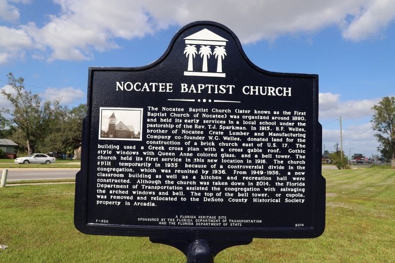
The town of Nocatee originated as a lumber manufacturing town during the 1880s. During the late 19th century. two businesses stimulated the town's growth. One was the King Lumber and Manufacturing Company, established by W.G. . . . — — Map (db m211953) HM
Bessie Coleman was the first African-American female to become a pilot, and the first African-American to hold an international pilot license.
She was born in Texas in 1892. After hearing stories of American airmen returning from World War I, . . . — — Map (db m237315) HM
In 1888 Oliver H. P. Champlin, a native of New York, platted the community of Eggleston and solicited religious settlers from New Jersey to come to Florida. He named his community Eggleston after his wife's family. Street names that still exist . . . — — Map (db m238171) HM
This area was originally a part of several Spanish land-grants developed by Francis Richard I, a native Italian. He and his sons would eventually obtain land grants totaling 32,000 acres. One of those grants was a 250 acre grant along Silversmith . . . — — Map (db m238128) HM
The Moncrief area (boundaries, 1-95 [east], Martin Luther King, Jr. Parkway [south], Moncrief Road & 29th Street [north] and Spires Street [west]) began in the late 1800s and by the early 1900s was a chief center of recreation in Jacksonville. . . . — — Map (db m235865) HM
Arlington Grammar School was built in 1921 to serve the children of white families living in an area of approximately 48 square miles stretching from the St. Johns River on the west eastward to what is today St. Johns Bluff Road and from the St. . . . — — Map (db m138830) HM
Lynching in America
Thousands of African Americans were victims of lynching and racial violence in the United States between 1877 and 1950. The lynching of African Americans during this era was a form of racial terrorism used to intimidate . . . — — Map (db m211856) HM
The point of land where the St. Johns River turns sharply east on its way to the ocean is by far the most prominent river point in the area known today as Old* Arlington. In 1772 this land was part of two plantations purchased by Captain William . . . — — Map (db m238191) HM
In 1772 Capt. William Reddy purchased two 400-acre tracts of land located where the St. Johns River bends eastward on its way to the Atlantic Ocean, naming them Hampstead and Point Plantations. Though Capt. Reddy only owned the property for two . . . — — Map (db m238188) HM
During Florida's 20-year British period from 1763 to 1783, St. Isabel was originally part of a 10,000 acre plantation granted in 1766 to the Earl of Bessborough, and later purchased in 1769 by London merchant Samuel Potts. After Florida was ceded . . . — — Map (db m238201) HM
The 8,000 acre Strawberry Mills and Plantation, part of a Spanish sawmill grant to Francis Richard, Jr., was purchased by John S. Sammis circa 1840. Sammis, a native of New York, moved to Florida in the 1820s and worked briefly for prominent . . . — — Map (db m139252) HM
In 1931 the red brick building that housed Brewster Hospital, the first private medical facility available to African Americans in Jacksonville opened.
Brewster Hospital evolved out of a class to train African-American women as nurses at the . . . — — Map (db m237314) HM
In the 1930s a new subdivision, Durkee Gardens, was started in the Mid-westside district. The community takes its name from the Durkee family, prominent whites in Jacksonville, who originally owned much of the property in the area. Many of the homes . . . — — Map (db m237306) HM
The Jefferson Street Pool was the first major municipal facility of its kind available to African Americans in Jacksonville. Prior to its establishment in 1951, a few community pools for black people had been created.
The Jefferson Street Pool . . . — — Map (db m237299) HM
The origin of the name has been lost. In any case, as a lifelong resident of this community, Mrs. Olivia Forest, stated
"life was sweet" in Sugar Hill. From its origins in the early 1900s through its hey-days - the 1920s to the 1960s - the height . . . — — Map (db m237304) HM
The birthplace of African-American archaeology can be traced to Kingsley Plantation, where archaeologists in 1968 first began to search for artifacts that reflected African identity. Many of the slaves that lived here during Zephaniah Kingsley's era . . . — — Map (db m40852) HM
Artifacts recovered by archaeologists provide clues as to who these enslaved African men, women and children were. This is most easily recognized within the realm of spirituality or religion, which is resistant to change. However, the physical . . . — — Map (db m41193) HM
After the Civil War, slavery ended, but former slaves continued to live on the island. In this new era, former slaves and new landowners had to make difficult choices.
In 1869 the Rollins family settled at the former plantation and called it . . . — — Map (db m145390) HM
The plantation era began in Florida in 1763 after Britain took control from Spain. Soon after, the first planter was given land here and brought his slaves and household.
Britain established a plantation economy and encouraged its growth by . . . — — Map (db m145387) HM
The plantation house symbolizes the owners and their freedom. The cabin ruins stand behind you as a testament to the enslaved and their lives of forced labor.
Explore the plantation grounds and discover the stories of plantation owners and . . . — — Map (db m40007) HM
In the spring of 1814, Zephaniah Kingsley relocated his family to this sea island plantation. Over the next two decades he developed his controversial views on race, society, and slavery.
Kingsley was a successful businessman who had strong . . . — — Map (db m40035) HM
The plantation era was a time in our history of opportunity, political contradictions and great cruelty.
For planters, like Zephaniah Kingsley, it was a time for amassing land and wealth. For enslaved Africans who produced the wealth it was a . . . — — Map (db m40085) HM
Imagine ... instead of the empty historic building and peaceful riverfront of today, a slave owner's family sits watching from the porch of their comfortable home as cargo-laden boats pass by on the river.
Breezes off the water cool the . . . — — Map (db m40043) HM
Imagine...instead of a lush green landscape of today, a long dusty road stretches to the slave cabins and field beyond.
Bent over cotton plants, under the hot sun with dust-filled air, enslaved people toil day in and day out amidst the odor of . . . — — Map (db m40077) HM
Cash crops, like sea island cotton, indigo, and sugar cane, made a profit for the owner. Other crops, like potatoes, okra, and yams, fed the families of both owners and slaves.
Sea island cotton was highly prized because of its long, strong, . . . — — Map (db m40143) HM
The House at the North end will be in the course of a month a very comfortable habitation, & in any other country a handsome situation. John McQueen, Jr., 1798
Planter John McQueen built the original portion of the house with the use of . . . — — Map (db m145389) HM
The exploitation of enslaved people differed throughout the Americas. However, the bottom line was profit for the owner, while for the slave it was loss of freedom.
Slaves were possessions. They were viewed as a valuable commodity to be bought . . . — — Map (db m83539) HM
Constructed nearly 200 hundred years ago, these cabins were home to enslaved people. Following emancipation, former slaves lived here and worked the land. Slowly, individuals and families moved away, leaving the buildings to fall into ruin. . . . — — Map (db m40543) HM
Slaves actively resisted bondage by purposefully slowing down their work pace, faking illness, or even mutilating themselves in order to lessen their value as human property.
Resisting the inhumanity of their enslaved condition, slaves . . . — — Map (db m40657) HM
In front of you are the remains of 25 cabins, the homes of 60 to 80 men, women, and children. These people had the strength to survive the misery of slavery.
Before dawn, slaves left for their day's labor, or to use their specialized skills. . . . — — Map (db m40689) HM
The island's landscape has changed dramatically since the plantation era. Gone are the roofs, fruit trees, wells, and garden plots. Trees and grasses now replace fields once tilled by slaves.
To be a slave was to be a human being under . . . — — Map (db m40847) HM
The slave quarters were a place to find identity and strength through family, faith, and shared experiences.
Many American traditions originate from the daily activities and beliefs of enslaved people. Practices that survive today revolve . . . — — Map (db m41248) HM
From the earliest age, children were trained to do their parents' work. They were terrified of the punishment their parents endured. Parents taught their enslaved children strict obedience so they could survive. And yet, like children today, they . . . — — Map (db m41272) HM
English:
Once the Portuguese made successful transatlantic trading voyages, other European nations quickly followed. In the eighteenth century, the port of Nantes became the busiest French port involved in the European slave trade . . . — — Map (db m145391) HM
English:
Slavery has been a component of human history through time. Whether captured, purchased, or taken as spoils of war, enslaved people had wide-ranging experiences, but they all shared one thing in common: loss of freedom. . . . — — Map (db m145392) HM
You are standing at the edge of two worlds. You are leaving the world of the owner and entering the world of the slave.
The cabin ruins before you are a vivid testament to the generations of slaves who lived there. On them depended the . . . — — Map (db m40120) HM
Many crops were grown on the plantation, but sea island cotton produced the highest profit. Growing and processing it required a complex work structure.
The task system was used to manage the many specialized requirements of sea island cotton . . . — — Map (db m40499) HM
Where there is now a tranquil river scene, a dock hustled and bustled with activity during the plantation era. Cotton bales were sent to market, and slaves and finished goods were brought here by boat.
Most plantations were located along . . . — — Map (db m145388) HM
The Cosmo community is located on the road that during the days of plantations led from the town of Fulton to St. Augustine, Florida. The origin of the Cosmo name remains a mystery but the residents of this small, close-knit black community took . . . — — Map (db m172514) HM
In 1806 Anna Madgigine Jai, a 13 year old girl of royal lineage in Senegal, West Africa, was sold into slavery and brought to the port of Havana, Cuba. There she was purchased by 38-year-old Zephaniah Kingsley, Jr., a wealthy white plantation . . . — — Map (db m138877) HM
From 1847 until sometime before 1860 Jacksonville University campus was the site of the Chesterfield farm of Anna Madgigine Jai Kingsley, former slave and widow of white plantation owner Zephaniah Kingsley. This farm was at the center of the . . . — — Map (db m138876) HM
This magnificent building was built in 1917 after the Great Fire of 1901. It replaced an earlier structure on the same site (pictured on right). The school was named for Lincoln's Secretary of War, Edwin Stanton, who was instrumental in creation of . . . — — Map (db m230621) HM
This is the last remaining one-room schoolhouse in Duval County, built in 1898 on the St. Joseph’s Church property at the corner of Loreto and Old St. Augustine Roads. It was part of the community school begun in 1868 by the Sisters of St. . . . — — Map (db m171614) HM
Founded in 1866, Edward Waters College (EWC) is the oldest historically black college in Florida. The history of the college is closely tied to the African Methodist Episcopal (AME) Church. In 1865, the Reverend Charles H. Pearch, a presiding elder . . . — — Map (db m93073) HM
Durkeeville is the historic African-American community that began in the 1930s. It encompasses Durkee Gardens (an affluent subdivision), and is partly located in Mid-Westside Jacksonville. The community is named for the Durkee family that owned . . . — — Map (db m149105) HM
This site has been the location of baseball and other sports for nearly 100 years.
The location has been know at different times as Barrs Field, the Myrtle Avenue Ball Park, Joseph H. Durkee Memorial Athletic Field, and since 1980, James P. . . . — — Map (db m149085) HM
By the 1930s the African-American community of Sugar Hill continued to expand north and west of West Eighth Street and spilled over into another region, Mid-Westside Jacksonville, defined by the following boundaries, I-95 (east), Martin Luther . . . — — Map (db m149108) HM
Manhattan Beach was Florida’s first African American beach resort. In 1900, Henry Flagler reserved Manhattan Beach for black employees of his Florida East Coast Railway and Florida East Coast Hotel companies. African Americans, who comprised a . . . — — Map (db m173936) HM
Pioneer Abraham Lincoln Lewis (1865-1947) and others founded Florida’s oldest African-American insurance company, Afro-American Life in 1901, which spread throughout the South as far as Texas. In 1926, A.L. Lewis opened Lincoln Golf and Country Club . . . — — Map (db m58382) HM
Booker T. Washington was born to Jane Ferguson, slave and cook on the James Burroughs plantation, in Hardy, Virginia, in 1856. Beneath the trees of a local park, a group of slaves, including 9-year-old Washington, learned of their freedom when . . . — — Map (db m142588) HM
Frederick Douglass was one of the foremost leaders of the abolitionist movement during the years prior to the Civil War. Douglass lived and worked in Rochester, NY for most of his public career. After the close of the Civil War he moved to . . . — — Map (db m142693) HM
An important writer and abolitionist, Harriet Beecher Stowe wrote “Uncle Tom’s Cabin” in 1852. During the Reconstruction, Stowe and many other northerners came to Florida with dreams of turning the wild, subtropical state into a haven . . . — — Map (db m142807) HM
The Third Union invasion was significant because it was the first deployment of African American troops in Florida by the federal government. The 33rd USCT (United States Colored Troops), formerly known as the 1st South Carolina Colored Infantry . . . — — Map (db m143682) WM
In 1922, the Duval County Board of Public Instruction opened South Jacksonville School No.107, the only public school on the southside of Jacksonville for African-American children in grades one through nine. Spearheading the building of this . . . — — Map (db m172473) HM
St. Nicholas Cemetery is one of the oldest and largest cemeteries associated with the historic African American communities of St. Nicholas, Philips, and Larsen/Pine Forest of South Jacksonville. Other associated community names include Spring Glen, . . . — — Map (db m220557) HM
Midway A.M.E. Church was organized on Sunday, June 10, 1865, a few weeks after the Confederate Army in Florida surrendered to the Union Army. It was thus the first black independent church organized in Florida. William G. Steward was sent to Florida . . . — — Map (db m59094) HM
On Saturday, August 27,1960, 40 Youth Council demonstrators from the Jacksonville Branch of the National Association for the Advancement of Colored People (NAACP) advised by local civil rights leader Rutledge H. Pearson (1929-1967), sat in at the . . . — — Map (db m58011) HM
Side 1
Asa Philip Randolph was born on April 15, 1889, in Crescent City, Florida. In 1891, his family moved to Jacksonville, which had a thriving, well-established African American community. From his father, Randolph learned that color was . . . — — Map (db m165849) HM
Black Historical Tour
Bethel Baptist
Institutional Church
founded in 1838
Jacksonville’ first organized
Baptist church
“Bethel’s light must ever shine
God’s message it must send
and it must beam eternally
into the hearts of men” . . . — — Map (db m220937) HM
The Afro-American Insurance Company, formerly the Afro-American Industrial and Benefits Association, was founded in 1901 to provide affordable health insurance and death benefits to the state's African-Americans. Founded by the Reverend E.J. Gregg, . . . — — Map (db m59633) HM
Jacksonville was an important port on the St. Johns River during the Civil War. It changed hands four times, finally ending up under Union control. In 1864, determined to prevent the city from once again falling into Confederate hands, the Union . . . — — Map (db m148596) HM WM
On this site, in a small frame house, James Weldon Johnson was borne on June 17, 1871. He was the first African-American to pass the State Bar Exam in Florida, the first African-American Secretary of the NAACP, and a noted educator, author, . . . — — Map (db m148645) HM
On this site, in a small frame house, John Rosamond Johnson was born on August 11, 1873. Rosamond was a genuine prodigy, teaching himself piano by age 4. In 1890, he attended the New England Conservatory of Music in Boston. He then later studied . . . — — Map (db m148648) HM
(side 1)
Joseph E. Lee, one of Florida's most distinguished adopted sons, was born in Philadelphia in 1849. Shortly after obtaining a law degree from Howard University in 1873, Lee began to practice in Florida as Jacksonville's first black . . . — — Map (db m129570) HM
Built in 1885 as a private residence, Old Brewster Hospital and Nursing Training School was the first medical facility to serve Jacksonville’s African-American community. Located in the LaVilla neighborhood, the hospital opened in 1901 through the . . . — — Map (db m93261) HM
The founders of Second Missionary Baptist Church worshipped at Bethel Baptist Church with their slaves masters in the 1830s. They built their first separate wooden sanctuary in 1848 in the African American neighborhood of LaVilla. The first . . . — — Map (db m101663) HM
This original sanctuary of the St. Joseph Missionary Baptist Church is one of the few remaining institutional buildings directly associated with the old community of Hansontown. Originally a farming cooperative established for black Union soldiers, . . . — — Map (db m92954) HM
Magee Field is named in honor of Dr. A.S. Magee, a local physician
who owned a pharmacy at Alcaniz and LaRua Streets. His residence
was at the southwest corner of Blount Street and 8th Avenue. A letter
to the editor of the Colored Citizen . . . — — Map (db m177059) HM
The house on the left is the birthplace of the first African American four
star general, Daniel "Chappie" James, Jr. (1920-1978). The steps on the
right are the remnants of the private school run by his mother, Mrs. Lillie
James, where he . . . — — Map (db m177307) HM
Originally the site of a dry goods store owned by Tierce Lee, a wealthy
black businessman listed in the Dunn and Bradstreet reports, and his
brother Shef, the building was bought by their brother Hamp and his
wife Ola in 1944 and converted to the . . . — — Map (db m177072) HM
Historic John the Baptist Church is the oldest Baptist congregation in Pensacola. In 1846, the First Baptist Colored Church of Pensacola, known as Historic John the Baptist Church since 1927, was organized in the Seville Square community. The . . . — — Map (db m72246) HM
Born in 1838, John Sunday, a wealthy free man of color owned large
tracts of land and many houses in Pensacola including several properties
in the Eastside Neighborhood area. Mr. Sunday served as a Civil War
soldier who became a member of the . . . — — Map (db m177069) HM
On this site, Pensacola Junior College (PJC) opened its doors on September 13, 1948. It was the first public junior college created by the Florida Legislature under the Minimum Foundation Program Act of 1947, signed into law by Governor Millard F. . . . — — Map (db m72248) HM
Front
Pensacola, an important early center of blues, ragtime, vaudeville and jazz activity, developed into a regional cornerstone of the “chitlin’ circuit” in later years. Touring blues, jazz and rhythm & blues acts, and local bands . . . — — Map (db m130678) HM
This building, once occupied by a Woolworth’s five and dime store, played a role in the struggle for civil rights in Florida. In the 1950s and 1960s, African Americans in segregated communities began sit-ins to protest against “whites . . . — — Map (db m110472) HM
Salvador Pons was the second son of John Pons, a seaman from Maryland, and Maria Rosario, a free woman of color. As a property owner who could read and write, Salvador was able to serve the Pensacola community as City Alderman beginning in 1869 and . . . — — Map (db m80048) HM
Spencer Bibbs Academy was named for the first African American Supervisor of Colored Schools in Escambia County. Appointed to the position in the early 1900s, Supervisor Bibbs went before the school board in 1919 to ask for an east side school and . . . — — Map (db m177314) HM
Spencer Bibbs Academy was named for the first African
American Supervisor of Colored Schools in Escambia County.
Appointed to the position in the early 1900s, Supervisor Bibbs went
before the school board in 1919 to ask for an east side school . . . — — Map (db m177077) HM
The Sisters of Mercy began the Catholic Church's work for blacks in Pensacola when they opened St. Joseph Colored and Creole School on September 8, 1879. St. Joseph Catholic Church, built in 1891, was the 1st African-American parish in the Diocese . . . — — Map (db m72247) HM
This site commemorates a neighborhood that existed in Pensacola until
the late 1970's when construction of Interstate 110 uprooted long-established businesses, residences and churches. Once a vibrant, thriving
community, this was one of numerous . . . — — Map (db m177064) HM
This building was erected in 1896 and rented to numerous businesses until the 1950s. One of the most significant tenants in the early 1900s was Samuel Charles, one of Pensacola's most prominent black businessmen, whose shoe repair shop became . . . — — Map (db m72239) HM
Middle Passage to Pensacola
Beginning in the early 1500s and continuing for more than three
centuries, about 12 million enslaved Africans were transported
across the Atlantic Ocean from Africa to the Americas. This
transportation, known . . . — — Map (db m177047) HM
The last step in producing sugar on my plantation involved getting it ready to ship north to market. Once the molasses drained from the hogsheads in the curing room, slaves transferred both the sugar and the molasses to this loading area between . . . — — Map (db m234835) HM
When the Bulow Plantation was active, these boat slips harbored both work and pleasure crafts. The slips have, fortunately, survived time because John Bulow reinforced the embankments with ale and wine bottles which were discarded from house . . . — — Map (db m191598) HM
The Bulow Ville plantation house was built in the early 1820s and believed to have resembled the mansion shown. The two and a half story building faced Bulow Creek and had a veranda on all sides. The first floor walls were coquina covered with . . . — — Map (db m191597) HM
Running a successful sugar plantation like mine required a lot of energy. Before the 1800s, sugar mills were largely operated by animal power. Horses or oxen turned the gears that moved the large rollers used to crush cane. By the time I built . . . — — Map (db m234825) HM
Vats and drying racks were used for the production of indigo. The vats were large, holding up to two thousand gallons of liquid. The stems and leaves were cut and laid in the larger vat. The stems were covered with a urine and water mix and left to . . . — — Map (db m191593) HM
After granulating and cooling in the sugar house, my sugar was still not ready to ship out. Although it was granulated, the sugar was still wet with molasses. Slaves scored and spaded this cooled sugar into hogsheads, or large barrels, located . . . — — Map (db m234827) HM
Getting sugar out of the sugar cane was very hard work. Not only did slaves have to cut the cane exactly when it was mature, they had to crush it and boil the juice as soon as possible in order to get the most and best sugar out of the crop. . . . — — Map (db m234836) HM
The slave cabin sites evidence the life of enslaved Africans and their forced labor that built and operated this plantation.
The 40 cabins were home to 197 men, women, and children according to the 1830 U.S. Census.
Cabins were arranged . . . — — Map (db m191596) HM
Each 12 foot by 16 foot cabin had shingled roofs, board floors and walls, with a coquina fire place.
Cabins were outfitted with common household items such as furniture, storage containers and table wear.
A fire pit in the yard was used . . . — — Map (db m191605) HM
Seminoles Become Residents of Florida
Groups of lower Creeks began moving into Florida from central Georgia about 1715. Fifty years later they had established a separate identity as Seminoles. Seminoles were not a united tribe but a group . . . — — Map (db m209524) HM
Apalachicola’s layout was organized in the mid 1830s by the Apalachicola Land Company. The original plan, patterned after the City of Philadelphia, featured a one-mile square grid with a large central square and smaller squares surrounding it. Each . . . — — Map (db m121998) HM
Side A
Built in 1814 by Lieutenant Colonel Edward Nichols, His Majesty's Marines, as a rallying point to encourage the Seminole Indians to ally themselves with England against the United States in the War of 1812. Abandoned after 1814, . . . — — Map (db m116355) HM
Atop this large prehistoric mound stood Nicolls' Outpost, a British fort of the War of 1812. Built in the fall of 1814, it was a rectangular earthen redoubt with a surrounding stockade and was armed with two small cannons. Garrisoned by 180 white . . . — — Map (db m79455) HM
Folklife is the traditional cultural expression of a community or group—foods prepared for a church potluck, games played with a neighbor, songs sung in a community, crafts passed down in a family. While many older traditions persist in the Upper . . . — — Map (db m230326) HM
From homemade jellies to boiled peanuts, the heritage of the Suwannee River Valley is experienced through local foodways. For example, Chicken Pilau - a chicken and rice dish cooked over an open fire - has been a culinary tradition in Florida for . . . — — Map (db m230333) HM
Each person is an archive of memories, knowledge and skills. As traditions pass from one generation to another, they transform and take on new meaning. Some old ways of life fall out of practice, while others are made new again. From building quail . . . — — Map (db m230341) HM
693 entries matched your criteria. Entries 101 through 200 are listed above. ⊲ Previous 100 — Next 100 ⊳