On North Broadway Street (U.S. 27 & 68) north of West 2nd Street, on the right when traveling north.
(obverse)
Thomas Hunt Morgan
Winner of 1933 Nobel Prize was born in Hunt-Morgan house, 1866; grew up here. A nephew of John Hunt Morgan, he attended State College of Ky. (Univ. of Ky.). Taught at Columbia Univ. and there, . . . — — Map (db m57474) HM
On West Third Street at Blackburn Avenue on West Third Street.
Boyhood home of prominent American historical painter and portraitist. Noble (1835-1907) was first Director of the Art Academy of Cincinnati. He studied in Louisville under Samuel W. Price, in France under Thomas Couture, and at the Munich Academy. . . . — — Map (db m136931) HM
On West 3rd. Street, 0.1 miles west of Market Street, on the right when traveling west. Reported missing.
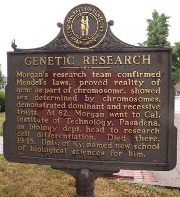
Pioneer in higher education in Kentucky and west. Founded by The Commonwealth of Virginia, 1780. Located in Lexington since 1789 — — Map (db m59049) HM
On Main Street (U.S. 25, 421) west of Jefferson Street (Kentucky Route 1928), on the left when traveling west.
Born in Lexington, son of Henry A. Tandy, respected African American contractor. Attended the Chandler School, Tuskegee Institute, Cornell Univ. 1st registered black architect in New York State, where he built landmark homes & buildings. A founder . . . — — Map (db m61032) HM
On West Broadway Street at St. Clair Street, on the right when traveling west on West Broadway Street.
(panel 1)
Governor William Goebel
The able and most effective advocate
and champion of the peoples cause
their loved and loyal friend.
On January 30th, 1900, he was shot
down by an assassin from the private
office of the . . . — — Map (db m123826) HM
On University Drive, on the right when traveling north.
(Front) School was chartered 1886; opened 1887 with three teachers and 55 students. The first state-supported institution of higher education for blacks, school gained funds from legislature for building and teachers, and from Frankfort city . . . — — Map (db m84462) HM
On Clifton Avenue, 0.5 miles west of Cheek Street, on the left when traveling west.
Firing an artillery piece required a carefully choreographed sequence of actions. On the command load, each man on the gun crew performed specific tasks to prepare the piece.
Step One—Load
1 sponges the barrel. 2 takes the . . . — — Map (db m162497) HM
On Wapping Street at Washington Street, on the left when traveling west on Wapping Street.
(Front) Lilian Lindsey, who lived in the Vest-Lindsey House, founded the Frankfort Public Library. It opened on December 12, 1908, in the McClure Building, and was managed by the Frankfort Woman's Club until 1965. The library moved to the . . . — — Map (db m84432) HM
On Mero Street (Kentucky Route 420) just east of Wilkinson Boulevard (U.S. 421), on the right when traveling west.
Erected in 1928 and dedicated September 3,
1929, Mayo-Underwood High School replaced
the 1884 Clinton Street High School. Mayo-
Underwoods main entrance faced Center
Street, with the Mero Street side encompassing
the 400 block, and the rear . . . — — Map (db m194238) HM
On Moscow Street (State Highway 94), on the right when traveling west.
Born in Hickman, Mr. Stahr became one of the towns most decorated citizens. Having studied in England as a Rhodes Scholar, Mr. Stahr went on to become President John F. Kennedy's selection as Secretary of the Army in 1961. During his tenure, the . . . — — Map (db m18448) HM
On Moscow Street (State Highway 94), on the right when traveling west.
Noted as one of Kentucky's most famous African American citizens, Hickman's Atwood served as the president of Kentucky State College from 1929 to 1962. During his tenure at the school, Atwood led the battle for desegregated education and improved . . . — — Map (db m18442) HM
On State Highway 339, 0.1 miles south of County Line Road (State Highway 1820), on the right when traveling south.
Site of Melber School
Site of 1st Melber school building in 1897. Became Melber Jr. H. S. in 1903. Building burned on Oct. 1, 1929. New brick building opened Aug. 25, 1930. Between 1937-1954, Melber served grades 1-12, and between 1954 1963, . . . — — Map (db m158897) HM
On S. 2nd Street at W. Court Street, on the right when traveling south on S. 2nd Street.
Graham was born & raised in Green Co. He was headmaster of Greensburg Academy, located at this site, from 1818-1823. In 1826, he moved to New Salem, Il. where Abraham Lincoln attended his school learning grammar and arithmetic. They remained close . . . — — Map (db m124184) HM
On Hudgins Highway (State Highway 569) at Hodgenville Road (State Highway 61), on the right when traveling west on Hudgins Highway.
Three miles west, birthplace of Mentor Graham, 1800-86, “The Man Who Taught Lincoln”. Sixty years a teacher. Green County 1818-26. After Illinois voted down slavery, moved to New Salem, 1826. There, from 1831-37, as tutor and friend, he . . . — — Map (db m124186) HM
By your own soul’s law learn to live. And if men thwart you, take no heed. If men hate you, have no care; sing your own song, dream your dream, hope your hope, and pray your prayer. — — Map (db m126372) HM
On East Kentucky Road (SR 1) at W. Hollow Road on East Kentucky Road (SR 1).
This Kentucky Poet Laureate was born and lived most of his life in W-Hollow, near Greenup. An educator and prolific writer, Stuart authored books, short stories, and poems which portray Appalachian Ky. He received Guggenheim fellowship, 1937; . . . — — Map (db m73779) HM
On River Road (State Road 334) 0.5 miles south of Adair Road (State Road 1605), on the right when traveling south.
Abraham Lincoln, 16th president of United States, won his first law case here, 1827. Charged by the Commonwealth of Kentucky with operating ferry without license; Lincoln pleaded his own case in trial at the home of presiding Justice of the Peace, . . . — — Map (db m160222) HM
On Dixie Highway East (U.S. 31W) just north of North Crestwood Street, on the left when traveling west.
Bond-Washington School
This site purchased in 1869 by the
trustees of the African School of
Elizabethtown. It was the location
of District A School from 1888-
1923, when East Side High School
was built with aid from the local
African . . . — — Map (db m223268) HM
On N Main just south of West Poplar Street, on the left when traveling north.
This Georgian mansion was built in 1825 by John Y. Hill. It is known as "Hill House" and as "Aunt Beck Hill's Boarding House." Jenny Lind sang here in 1851 and George Armstrong Custer and wife boarded here, 1871-73. Doctors William Allen and Robert . . . — — Map (db m171013) HM
On State Highway 6, 0.3 miles east of Maggard Street, on the right when traveling east.
Principal of the East Benham High School, 1934-60. Matthews taught math and coached ball teams. The students were children of employees of Wisconsin Steel Company. Joseph Matthews and his wife Ruth were leaders in black community and bought food, . . . — — Map (db m97118) HM
On South 2nd Street just north of East Clover Street, on the left when traveling north.
Harlan County is made up of 6 cities and each one is unique in its own right.
Benham
Benham was formerly a coal camp that was built by some major coal mining companies. It was incorporated in 1961. At one point, this town was booming . . . — — Map (db m181399) HM
On State Highway 6 east of Pirate Way, on the left when traveling east.
(Side One)
This brick facility was built in 1923 by the United States Coal and Coke Co., then leased to Lynch Colored Common Graded School District. Students from Benham and Lynch enrolled in the high school. The first four graduates . . . — — Map (db m97161) HM
Near State Highway 510 east of State Highway 221, on the right when traveling east.
Pine Mountain Settlement School – Realizing the need for better education in the area, William Creech donated land for the school. Katherine Pettit, founder of the Hindman Settlement School, and Ethel De Long Zande opened the school in 1913. It . . . — — Map (db m212425) HM
On West Penn Street at County Road 1004, on the right when traveling west on West Penn Street.
School named for Benjamin Banneker
Principals were
W. E. Newsom
E. O. David
Consolidated with
Harrison County School System 1963 — — Map (db m218105) HM
Carter-Dowling School Upon closing its one room schools in 1950, the Hart County Board of Education constructed Carter-Dowling School, a consolidated elementary school for "colored" children of Hart County. The School was named for Daisie C. . . . — — Map (db m39983) HM
On E South Street north of Main Street (U.S. 31W), on the left when traveling north.
(Side A)
In 1945, Hart County had 67 One-Room Schools scattered throughout the county. These 67 schools served students in grades first through eighth.
Not quite a decade later, all One-Room Schools in Hart County had been closed. At . . . — — Map (db m174340) HM
On Legrande Highway (Kentucky Route 218) north of Center Three Springs Road, on the right when traveling east. Reported missing.
Author, newspaperman. Wrote more than 40 books based on American history and designed especially for young people. A native of Three Springs, educated at Glasgow, Ky., and Vanderbilt Univ. On staff of the Louisville Courier-Journal, 1885-92; joined . . . — — Map (db m54730) HM
On Eminence Pike (Kentucky Route 55) south of Mulberry Road (Kentucky Route 1899), on the right when traveling south.
Chartered as a high school by
Kentucky Legislature in 1856. The
school had trustees Dr. D.
Porter, S.T. Drane, Morris Thomas,
Preston Thomas, James Drane, W. B.
Wilson, and W. J. Mason. In 1861,
the name Eminence College conferred
on it. Men . . . — — Map (db m136246) HM
On Washington Street (U.S. 51) at Clay Street (State Highway 58), on the right when traveling south on Washington Street.
First high school in Ky. west of Tenn. River established at Clinton, 1846. Frame structure erected; burned 1854. In 1850, Clinton Female Seminary was incorporated. Organized as Clinton Academy as charter made no mention of only women students. . . . — — Map (db m36982) HM
On South Lee Trover Todd Jr Highway (U.S. 41) at West Main Street (State Route 112), on the left when traveling north on South Lee Trover Todd Jr Highway.
Earlington founded in 1870 by St. Bernard Coal Co. Named for John Baylis Earle, who discovered No. 11 coal vein not far from this site, in 1869. John Bond Atkinson, the president of St. Bernard Coal, planned free public schools, free public library, . . . — — Map (db m88929) HM
On North Mc Euen Avenue (Kentucky Route 1337) north of County Route 3057, on the right when traveling north.
J.W. Million School
Black students went to Earlington Colored School by 1891. Wooden school replaced by brick building in 1905 by St. Bernard Mining Co. on land donated by J.B. Atkinson.
Inspired by Rev. Joseph W. Million, activist and . . . — — Map (db m171876) HM
On Union Street, 0.1 miles north of East Broadway Street, on the left when traveling north.
Born Jan. 15, 1869, Madisonville. Began law practice, 1892. Served as chairman of the first Insurance Rating Board, 1912. Circuit Court Judge, 1921-31. While Governor, 1931-35, he reorganized charitable and penal boards; recodified the educational . . . — — Map (db m88785) HM
On Beulah Road (Kentucky Route 70) 0.1 miles north of Beagle Park Loop (Kentucky Route 1302), on the left when traveling north.
Munns School was a one-room log structure
named for Eleanor Munns who once owned
the land. The present brick building was
built in 1879 and another room was added
in 1927-28. Munns School, used as a
Hopkins County school and a . . . — — Map (db m171881) HM
On North Kentucky Avenue at Couch Street, on the right when traveling north on North Kentucky Avenue.
Rosenwald High School
Here, Professor C. L. Timberlake established first high school in city for blacks. Rosenwald High School opened in 1932; operated until 1966. Rosenwald Foundation funded its construction. In 1936, basketball team . . . — — Map (db m88950) HM
On South Main Street (Kentucky Route 2083) at Kentucky Route 4002, on the right when traveling south on South Main Street.
Side 1
Cmdr. D. W. "Mush" Morton, USN
This World War II hero spent his early youth & attended elementary school in Nortonville, high school in Madisonville. Graduated from U.S. Naval Academy in Annapolis, Md., in 1930. Became . . . — — Map (db m88927) HM
On Watterson Trail south of Taylorsville Road (Kentucky Road 155), on the right when traveling south.
St. Edward Church began on this site on May 15, 1878, as St. Agnes Mission when 30 Catholic families gathered for Mass in a small log cabin on Market Street (Taylorsville Rd). By 1881 they had raised $700 to purchase a small plot of land 132 feet . . . — — Map (db m161797) HM
On Fern Creek Road at Ferndale Road, on the left when traveling north on Fern Creek Road.
Built on land purchased from S. A. Stivers; school opened with 25 pupils, Sept. 17, 1923. Established as alternative to distant Louisville schools, Fern Creek was a two-year school at first but later adopted a four-year program. The first four year . . . — — Map (db m204265) HM
On Berrytown Road east of La Grange Road (Kentucky Road 146), on the right when traveling east.
The Forest School was originally built in 1905 as one room, located between Anchorage and Obannon Road. The school was later relocated to two lots on Berrytown Road. In 1912 an additional room was added and in 1928 another room was added giving the . . . — — Map (db m161777) HM
On Stonestreet Road, on the right when traveling north.
Born in Jefferson Co., Stonestreet was the first woman to be elected superintendent of Jefferson Co. schools. An 1877 graduate of Nazareth Academy, she became a teacher in 1889. In 1897 she was elected superintendent by 845 votes, defeating two men. . . . — — Map (db m161669) HM
On St. Andrews Church Road, on the right when traveling east.
Wisertown
Area once known as Wisertown. Descendants and extended family of John (1793-1877) and Luzanna Wiser(1804-1873) lived here, including Gagels, Arnolds, and Webers. John came here 1817, married Luzanna 1821, bought farm 1838. They . . . — — Map (db m161573) HM
On East Washington Street, on the right when traveling east.
Parish established in 1866 by Bishop Martin J. Spalding to serve the German and Irish Catholics in Butchertown. Reverend Leopold Walterspiel appointed to organize congregation under the patronage of St. Joseph. The present church was dedicated in . . . — — Map (db m161179) HM
On Cherokee Parkway at Everett Avenue, on the right when traveling north on Cherokee Parkway.
Highland Mothers Club
Founded by Mary K. Lee and the mothers of her Highlands students. They began meeting in their homes, & later at Douglas Blvd. Christian Church, before first local PTAs were organized. They studied and educated each . . . — — Map (db m161753) HM
On Virginia Avenue west of South 36th Street, on the left when traveling west.
The Virginia Avenue Colored School opened in 1923. It was constructed via a million-dollar bond the Louisville Board of Education used to acquire sites and build new structures. Samuel Plato, one of the country’s first African American architects, . . . — — Map (db m161680) HM
On Frankfort Avenue at Stoll Avenue, on the right when traveling west on Frankfort Avenue.
Founded on May 9, 1842, the Kentucky School for the Blind became the sixth school for the blind in the United States. The Kentucky Legislature approved the founding of the school by charter on February 5, 1842.
Two of the most important . . . — — Map (db m104467) HM
On Frankfort Avenue at Stoll Avenue, on the right when traveling west on Frankfort Avenue.
Since 1842
The Kentucky School for the Blind, third such state supported school in US. Dr. Samuel G. Howe of Boston, pioneer educator of blind, invited to Kentucky to give public demonstration with his own pupils. Displayed before Ky. Legislature . . . — — Map (db m104425) HM
Near South Clifton Avenue, on the right when traveling south.
St. Frances of Rome School
Opened Oct. 17, 1887. School first held in church, then wood-framed school, built 1889. Present bldg. designed by Thomas Nolan, Sr. in Spanish Baroque style, dedicated in 1930. By 1889, 203 students were enrolled. . . . — — Map (db m161992) HM
On East Jefferson Street at South Floyd Street, on the left when traveling west on East Jefferson Street.
Born on this street, Alice Virginia was one of seven founders of P.E.O., an international philanthropic and educational organization for women. It began as a sorority at the Iowa Wesleyan College, 1869; owns Cottey College in Missouri, and provides . . . — — Map (db m203221) HM
On West Chestnut Street at South 1st Street, on the left when traveling east on West Chestnut Street.
Founded in 1869, the college was one of four medical institutions in city which merged with Medical Dept. of University of Louisville, 1908. College built this limestone Richardsonian Romanesque structure 1891-1893. Building was designed by firm of . . . — — Map (db m161258) HM
On South 8th Street south of West Muhammad Ali Boulevard, on the left when traveling south.
Nannie Helen Burroughs A suffragist, orator, educator, & club/church leader for gender and racial equality, she worked in Louisville for the Foreign Mission Board of Nat’l Baptist Convention from 1900-1910. She created the Woman’s Industrial . . . — — Map (db m203253) HM
On South 8th Street at West Liberty Street (U.S. 60), on the right when traveling south on South 8th Street.
Site of Kentucky's only Catholic high school for blacks. It existed at this location from 1928-1958, operated by the Archdiocese of Louisville. Founded in 1921, the school was administered by pastors of St. Augustine and St. Peter Claver churches, . . . — — Map (db m162237) HM
On South 6th Street south of West Muhammad Ali Boulevard, on the left when traveling south.
On this site stood the George D. Prentice School, which was one of nineteen in Louisville that were commandeered for use as hospitals during Civil War. Worden Pope, an early Louisville civic and political leader, built his home here ca. 1830. It . . . — — Map (db m203373) HM
On West Muhammed Ali Boulevard at South Fourth Street, on the right when traveling west on West Muhammed Ali Boulevard.
Thomas Merton - (1915-68)
Trappist monk, poet, social critic, and spiritual writer. Born in Prades, France. After education at Cambridge and Columbia Univ., he entered Abbey of Gethsemani, Trappist, Ky., 1941; ordained as priest, 1949. His . . . — — Map (db m144470) HM
On West Kenwood Drive at Kenwood Hill Road, on the right when traveling east on West Kenwood Drive.
The Little Loomhouse
Lou Tate Bousman (1906-79), born in Bowling Green, Ky. During Arts & Crafts movement, at Pres. Hoover’s request, she traveled Appalachia preserving historic coverlet patterns. Her work with Mrs. Hoover led to the . . . — — Map (db m161569) HM
On West Kentucky Street west of South 7th Street (Kentucky Route 1931), on the right when traveling east.
Located on original site of Simmons University and Bible Collège, a black institution. Opened Feb. 9, 1931, as the segregated branch of University of Louisville in response to black political activism. It was third municipally supported college for . . . — — Map (db m203388) HM
On West Kentucky Street at South 6th Street, on the right when traveling east on West Kentucky Street.
Designed in 1873 by B.J. McElfatrick, architect, as first black public school in Ky. Central Colored School served as cultural and educational center for city's black community until 1894. Then, because of overcrowding, Central relocated. Education . . . — — Map (db m161289) HM
On South 6th Street, on the right when traveling south. Reported missing.
Built in 1888 for German immigrant and hotelier Louis Seelbach (1852-1925) and designed by architects Wehle and Dodd in a modified Richardsonian Romanesque form. This house set the tone for other houses built on this block. In 1905, Seelbach & his . . . — — Map (db m161287) HM
On South 7th Street north of Zane Street, on the left when traveling north.
School proposed by Gen. Assoc. of Colored Baptists in Kentucky and chartered through legislature in 1873 as Ky. Normal and Theological Institute. Frankfort was the first site suggested but Assoc. selected Louisville. Charter amended in 1882, . . . — — Map (db m161288) HM
On Belgravia Court at St. James Court, on the right when traveling north on Belgravia Court.
Louisville Gay Liberation Front. In July 1970, the LGLF became the 1st org. in Ky. to openly advocate for gay equality. 17 young gay liberationists met in an apt. at 420 Belgravia Ct. owned by LGBTQ advocate Jack Kersey to protest Jones & . . . — — Map (db m248236) HM
On West Lee Street at South 2nd Street (State Road 1020), on the right when traveling east on West Lee Street.
Serving girls' education for almost 100 years, school was originally known as Female High School and provided women of Louisville with a strong educational base. Opened on April 7, 1856 at Center and Walnut, school functioned on 1st Street and at . . . — — Map (db m161356) HM
On South 4th Street north of West Breckinridge Street, on the right when traveling north.
The city's first Catholic school and Louisville's oldest existing school, founded 1831, by Mother Catherine Spalding. Recognized as co-founder of Sisters of Charity of Nazareth with Bishop J. B. David, she began a hospital and city's first orphan . . . — — Map (db m161367) HM
On South 4th Street, 0.1 miles south of York Street, on the right when traveling south.
Remembering the life and legacy of the lake Derek Smith, Spalding University has named the campus gymnasium in honor of this wonderful man. Derek, a member of UDFL's 1980 NCAA Championship Team and a nine-year NBA star, held his first high school . . . — — Map (db m179906) HM
On East Liberty Street at St. Boniface Place, on the left when traveling east on East Liberty Street.
Founded in 1836 to serve German Catholics and named for the Apostle of Germany, St. Boniface is the oldest Catholic parish in Louisville existing under its original name. The Gothic-style church, dedicated in 1900, was designed by D. X. Murphy and . . . — — Map (db m161749) HM
On Montgomery Street east of North 26th Street, on the right when traveling east.
Built in 1853, the Montgomery Street School was an educational institution for 155 years. Designed in classic Renaissance Revival style, it is a significant example of a mid-19th century educational facility. During the Civil War, it likely served . . . — — Map (db m161706) HM
Near South 11th Street at West Chestnut School, on the left when traveling north.
Muhammad Ali, then Cassius Clay, graduated from Central High school in 1960, the same year he won an Olympic gold medal in Rome. Ali would run alongside the city bus. which transported students, and race it to school. Other notable alumni from . . . — — Map (db m248242) HM
On West Chestnut Street east of South 10th Street, on the right when traveling east.
Dr. James Bond (1863-1929)
Born in Woodford County during slavery, James Bond was raised in Knox Co. He led a young steer to Berea College for his tuition. In 1896, became a trustee of Berea. After Day Law passed, he joined college's staff . . . — — Map (db m161254) HM
On West Chestnut Street at South 10th Street, on the right when traveling east on West Chestnut Street.
This Carnegie-endowed library was one of the first in the nation to extend privileges to the black community. The library was first in William M. Andrews' residence at 1125 West Chestnut, now gone. The present library was designed by the . . . — — Map (db m161253) HM
On South Brook Street, on the right when traveling south.
Alpha Kappa Alpha Sorority, Inc. was founded on January 15, 1908 on the campus of Howard University. Led by visionary leader, Ethel Hedgeman Lyle, 16 students founded the sorority on five basic tenets: to cultivate and encourage high scholastic and . . . — — Map (db m203470) HM
On South Brook Street, on the right when traveling south.
Alpha Phi Alpha Fraternity,
Incorporated was founded on an ice-
cold Tuesday December 4th, 1906. It
was founded on the campus of
Cornell University in Ithaca, New
York by the seven "Jewels” (Henry
Arthur Callis, Charles Henry
Chapman, Eugene . . . — — Map (db m203469) HM
Journalist and nationally known civil rights activist, Anne Braden was a key leader in the struggle for racial justice from the 1950s until her death. Although she and her husband, Carl, were once considered the most hated couple in Louisville, she . . . — — Map (db m114970) HM
On South 3rd Street (State Road 1020) 0.2 miles north of Eastern Parkway (Alternate U.S. 60), on the right when traveling north.
Originally this was site of the old Industrial School of Reform and House of Refuge, established 1860. During Civil War, institution used by Union troops as barracks and parade grounds. The property, with several original buildings, taken over by . . . — — Map (db m161354) HM
Renowned educator, writer, and social scientist,
Charles Henry Parrish, Jr. was born on January 12,
1899, in Louisville, KY. A graduate of historic
Central High School in 1916, Parrish went on to
attend Howard University receiving his A.B. . . . — — Map (db m203466) HM
In 1950-51 University of Louisville campus was integrated. One African American professor came from Louisville Municipal College, where only blacks had previously been enrolled. Charles H. Parrish, Jr., a noted sociologist and a lifelong civil . . . — — Map (db m203464) HM
On South Brook Street, on the right when traveling south.
Delta Sigma Theta Sorority, Incorporated was founded on January 13, 1913 by 22 collegiate women at Howard University to promote academic excellence and provide assistance to those in need. The first public act performed by the Founders of Delta . . . — — Map (db m203474) HM
On W. Cardinal Boulevard, 0 miles S. 2nd Street, in the median.
Scholar and educator, Dr. Parrish joined the faculty of Simmons University in 1921 and moved to Louisville Municipal College, the black branch of the University of Louisville, in 1931. In 1951, when the University of Louisville desegregated and . . . — — Map (db m114910) HM
On W. Cardinal Boulevard just west of S. 2nd Street, on the left when traveling west.
Scholar and educator, Dr. Love became the first black librarian at the University of Kentucky in 1955 and, a decade later, became the first director of Project Upward Bound and an assistant dean at the University of Louisville. A faculty member in . . . — — Map (db m114913) HM
On S. 3rd Street, 0 miles south of W. Cardinal, on the left when traveling north.
Author and historian, Dr. Hudson served as Chair of the Department of Pan-African Studies and in 2005 became permanent Dean of the College of Arts and Sciences. Dr. Hudson was a scholar in global African ancestry, inter-cultural education, . . . — — Map (db m114934) HM
Scholar, educator and activist, Dr. McMillan graduated from the University of Louisville in 1950. After a successful career as a public school educator in Michigan, Dr. McMillan returned to the University in 1976 as an assistant provost, professor . . . — — Map (db m115018) HM
Scholar and educator, Dr. Clement served as the first dean of Louisville Municipal College, the segregated branch of the University of Louisville, from 1931 to 1937. Under his leadership, Municipal attracted an extremely strong faculty and soon . . . — — Map (db m115014) HM
April 3, 1798, is the university's symbolic founding date. On this date, eight Louisvillians pledged financial support for a new school. The 1798 benefactors were: William Croghan, Alexander S. Bullitt, James Meriwether, John Thruston, Henry . . . — — Map (db m161352) HM
On South 3rd Street south of West Cardinal Boulevard, on the left when traveling south.
The United States faced two fundamental tasks during the Reconstruction period (1865-1877). One was the need to redefine and renormalize relations between the former Confederate states and the rest of the nation. The other was to redefine the role . . . — — Map (db m245713) HM
On South 2nd Street (Kentucky Route 1020) south of West Cardinal Boulevard, on the left when traveling north.
The fight against Hitler's fascism inspired a vigorous new postwar struggle against racism and discrimination at home. The NAACP legal battle began to bear fruit with Supreme Court decisions against segregation in transportation and restrictive . . . — — Map (db m245724) HM
On South Brook Street, on the right when traveling south.
Iota Phi Theta Fraternity, Incorporated was founded on September 19, 1963 on the campus of Morgan State University (then Morgan State College) by Albert Hicks, Lonnie Spruill, Jr., Charles Briscoe, Frank Coakley, John Slade, Barron Willis, Webster . . . — — Map (db m203480) HM
On West Brandeis Avenue, 0.1 miles west of S. 1st First, in the median.
This special plaza is dedicated to Jane Goldstein, Assistant Dean of UofL's College of Business.
Jane was a tireless advocate for the college, the university and the Louisville community. She taught, mentored, counseled, connected, funded, . . . — — Map (db m244642) HM
On South Brook Street, on the right when traveling south.
Kappa Alpha Psi Fraternity,
Incorporated was chartered and
incorporated on the campus of
Indiana University on January 5, 1911
with the sole purpose of achievement
in every field of human endeavor. This
was accomplished by the . . . — — Map (db m203472) HM
At this site rest cremated remains of U.S. Supreme Court Justice Louis Brandeis, who served on the Court from 1916-39. His support for the Law School, now named in his honor, is best shown by gift of his papers, which include more than 250,000 . . . — — Map (db m161353) HM
On South Brook Street, on the right when traveling south.
The National Pan-Hellenic Council (NPHC) was founded on May 10th, 1930 at Howard University. The founding members of the NPHC were Kappa Alpha Psi, Omega Psi Phi, Alpha Kappa Alpha, Delta Sigma Theta, and Zeta Phi Beta. The council's membership . . . — — Map (db m203468) HM
On South Brook Street, on the right when traveling south.
Omega Psi Phi Fraternity, Incorporated was founded on November 17th, 1911 on the campus of Howard University by Edgar Amos Love, Oscar J. Cooper, Frank Coleman and their Faculty Advisor, Dr. Ernest Everett Just. The Fraternity motto is “Friendship . . . — — Map (db m203473) HM
On South Brook Street, on the right when traveling south.
Phi Beta Sigma Fraternity, Incorporated was founded on Friday January 9th in 1914. It was founded on the beloved campus of Howard University in Washington, D.C. by the Honorable Founders Abram Langston Taylor, Leonard Francis Morse, and Charles . . . — — Map (db m203475) HM
On South Brook Street, on the right when traveling south.
Sigma Gamma Rho Sorority, Incorporated was founded on November 12th, 1922, on the campus of Butler University by seven young educators: Mary Lou Allison Gardner Little, Dorothy Hanley Whiteside, Vivian White Marbury, Nannie Mae Gahn Johnson, Hattie . . . — — Map (db m203478) HM
On West Cardinal Boulevard just west of S. 2nd Street.
Former mayor of Louisville and lieutenant governor of Kentucky, Wyatt also served as a member of the University of Louisville Board of Trustees and made the first motion to desegregate the University in 1949 — — Map (db m114911) HM
On W. Cardinal Boulevard at S. 2nd Street on W. Cardinal Boulevard.
Businessman and civil rights leader, Mr. Porter served twenty-four years on the board of trustees at the University of Louisville, four terms as chairman and helped guide the University into the state system of higher education. A firm believer that . . . — — Map (db m114950) HM
On South Brook Street, on the right when traveling south.
Zeta Phi Beta Sorority, Incorporated was founded on January 16th, 1920 on the campus of Howard University in Washington, D.C. by the organization's five Pearls (Arizona Cleaver Stemons, Pearl Anna Neal, Viola Tyler Goings, Myrtle Tyler Faithful & . . . — — Map (db m203477) HM
On Lyndon Lane at New La Grange Road (State Road 146), on the right when traveling north on Lyndon Lane.
An early settler, Alvin Wood, named this community in 1871. One of America's oldest military schools, Ky. Military Institute, founded, 1845; moved here, 1896. Points of interest in area: Central State Hospital, founded on site of Isaac Hite's home, . . . — — Map (db m161984) HM
On North Lexington Avenue (Kentucky Route 29) 0.1 miles south of West College Street, on the right when traveling south.
Bethel Academy
This was second Methodist school in United States. In 1790 Bishop Francis Asbury laid plans for Bethel Academy, four miles southeast of Wilmore on cliffs above Kentucky River. It was operating by 1794; closed ca. 1804, due to . . . — — Map (db m169977) HM
On Third Street (U.S. 40) at Court Street on Third Street. Reported missing.
Side One"Doer"
Mayo promoted railroads and helped organize banks to assist rail and coal companies. Having gained extensive wealth, he established many religious, educational and financial institutions to help the mountain people. . . . — — Map (db m106290) HM
360 entries matched your criteria. Entries 101 through 200 are listed above. ⊲ Previous 100 — Next 100 ⊳