On South 1st Street just north of Southeast Kent Street (State Route 92), on the right when traveling north.
This property is a contributing building to the Greenfield Public Square Historic District National Register of Historic Places by the United States Department of the Interior — — Map (db m193876) HM
On South 1st Street north of Southeast Kent Street (State Route 92), on the right when traveling north.
This property is a contributing building to the Greenfield Public Square Historic District National Register of Historic Places by the United States Department of the Interior — — Map (db m193877) HM
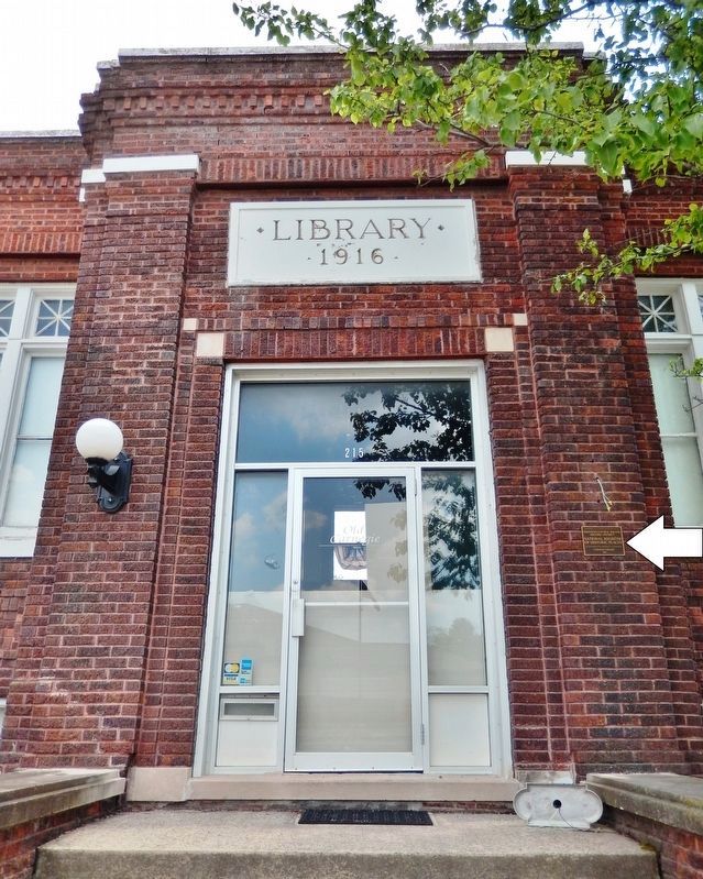
On Public Square just east of North 1st Street, on the right when traveling west.
This property is a contributing building to the Greenfield Public Square Historic District National Register of Historic Places by the United States Department of the Interior — — Map (db m193970) HM
On Allamakee Street, 0.1 miles north of 1st Ave. NW, on the right when traveling north.
The Norwegian-American Gjefle log house was built in 1870, and an addition in 1886, in Center Township. It was moved to this site in 1990. — — Map (db m69748) HM
On Chestnut Street at 1st Street, on the left when traveling north on Chestnut Street.
La Porte City's long history of protecting its citizens started with the formation of a bucket brigade in 1871. A bell summoned citizens to bring their buckets to fight fires. In those early years, the town’s volunteer fire department was praised . . . — — Map (db m193700) HM
On Main Street west of Commercial Street (U.S. 218), on the right when traveling west.
Mayor — Darrel Loveless City Council — Ivadell Bader • Kenneth Harmon • Gary Juhl Clifford McFarland • Duane Slaikeu Renovated 1982 by Junior L. McBride National Register of Historic Buildings — — Map (db m189799) HM
On 1st Street Southwest at East Bremer Avenue (State Route 3), on the right when traveling north on 1st Street Southwest.
Long before the Rock Island Railroad opened its new passenger depot in 1910 on land originally platted by William Sturdevant, this corner was an important commercial location. Edward Knott and his sons John and Alfred operated a horse importing and . . . — — Map (db m237099) HM
On 2nd Avenue Northwest just north of 1st Street West (County Highway D22), on the right when traveling north.
History of the Wapsipinicon Mill March 7, 1867 the Independence Mills Co. was organized for the purpose of buying water power and building a custom and merchants flouring mill. Work began immediately and began operation as a flouring mill . . . — — Map (db m162161) HM
On Lake Avenue North at West 3rd Street, on the left when traveling north on Lake Avenue North.
This property is listed in The National Register of Historic Places Iowa State Historical Department Division of Historic Preservation — — Map (db m238795) HM
On North Downey Street. Reported permanently removed.
"This cottage where I was born is physical proof of the unbounded opportunity of American life."
In 1871, Jesse Hoover built this two-room cottage near his blacksmith shop and moved in with his wife, Hulda, and young son, Theodore. . . . — — Map (db m162633) HM
On Downey Street at Wetherell Street, on the left when traveling east on Downey Street. Reported permanently removed.
Miss Amanda Garvin purchased this lot in 1870 and by 1872 had this small frame cottage built. She resided here until 1878. Herbert Hoover was familiar with this house and would have passed it often to and from school. The Garvin Cottage is . . . — — Map (db m162640) HM
On Downey Street south of Wetherell Street, on the left when traveling north. Reported permanently removed.
Charles Smith moved to West Branch in the 1880’s and pursued his trade as a carpenter and contractor. In 1903 Smith built this retirement dream home for himself and his wife. They celebrated many special occasions here including their 50th wedding . . . — — Map (db m162618) HM
On 1st Street NE north of State Street, on the right when traveling north.
Frank Lloyd Wright
1908
Prairie School Architecture
In Mason City
This Property is Listed in
The National Register of Historic Places
U.S. Department of [the] Interior — — Map (db m89571) HM
On State Street at Federal Avenue, on the left when traveling west on State Street.
Frank Lloyd Wright
1910
This property has
benn placed on the
National Register
of Historic Places
by the
United States Department
of the Interior — — Map (db m89586) HM
On Froelich Road, on the left when traveling east.
This store was built in 1891 by Edwin Froelich, after the previous general store burned down that had been located where the Frolelich Monument is currently located. It was called the Iron Clad Store for the exterior was covered with fire-proof . . . — — Map (db m203105) HM
On Washington Street (U.S. 63) south of Jefferson Street, on the right when traveling south.
Built in 1877 at a cost of $45,201, the Davis County courthouse is an outstanding example of Second Empire architecture with its distinctive mansard roof and dormer windows. The structure measures approximately 97 by 87 feet with walls made of . . . — — Map (db m90341) HM
On South Main Street at Division Street, on the right when traveling north on South Main Street.
No. 3003This S-4 Hudson class passenger locomotive was the fourth engine produced by the Baldwin Locomotive Works for the Chicago, Burlington and Quincy Railroad (CB&Q). In 1930 when the steam engine was built it was considered to be . . . — — Map (db m238371) HM
On Jefferson Street west of North 4th Street, on the left when traveling west.
This property has been placed on the National Register of Historic Places by the United States Department of the Interior Hedge's Building 1881 — — Map (db m238376) HM
On Hill Avenue at 18th Street (U.S. 71), on the right when traveling north on Hill Avenue.
This property is listed in The National Register of Historic Places Iowa State Historical Department Division of Historic Preservation — — Map (db m238671) HM
On Main Street north of West 4th Street, on the right when traveling south.
4th and Main Streets has hosted public entertainment since the 1840’s. Designed by America’s premier theater architects, CW and George Rapp, the Majestic is a Renaissance Revival style with French and Italian influences. The original structure, the . . . — — Map (db m126600) HM
On Central Avenue (U.S. 52) at East 8th Street, on the left when traveling south on Central Avenue.
Dubuque’s first jail stood on this site (1836) and was superseded by this building which has been in continuous use since 1857 as sheriff’s residence and jail. Its design is the finest example of Egyptian architecture to survive the classical . . . — — Map (db m126598) HM
On Central Avenue (U.S. 52) north of East 8th Street, on the left when traveling north.
Old Dubuque County Jail was built in 1857 by architect John Francis Rague. The Old Jail is one of only three surviving Egyptian Revival buildings in the entire United States. It is listed on the National Register of Historic Places and is also an . . . — — Map (db m126597) HM
On Riverside Drive just west of North Main Street, on the right when traveling west.
Iowa Historic District Central Park–North Main Street Historic District ———————— Farmer’s Trust and Savings Bank ca. 1900 This district is listed in The National Register of Historic Places — — Map (db m236691) HM
On 220th Trail west of 45th Avenue, on the right when traveling west.
The sandstone and frame building was erected in 1856 as a general store and a second floor residence. In 1890, the brick addition was erected. The Amana Society Main Office (Corporate Headquarters) was located in the frame portion of the building . . . — — Map (db m90203) HM
On East Market Street just west of North Clinton Street, on the right when traveling west.
Formerly First Presbyterian Church & North Presbyterian Church (Old School) Erected 1856-1865 This property is listed in the National Register of Historic Places — — Map (db m194099) HM
Near East Washington Street just west of South Clinton Street, on the right when traveling west.
Opened in 1902, the Hall of Liberal Arts was later renamed Schaeffer Hall for Charles A. Schaeffer, the University of Iowa president who turned the first spadeful of earth for the new building shortly before his death in 1898. The first of the four . . . — — Map (db m194175) HM
Near North Clinton Street at Iowa Avenue, on the right when traveling south.
This building the last Capitol of Iowa Territory became the first Capitol of the State of Iowa December 28, 1846 and was given to the University by and Act of the First General Assembly signed by Governor Ansel Briggs February 25, 1847 This . . . — — Map (db m194000) HM
Near South Madison Street at West Iowa Avenue, on the right when traveling north.
Builded by the Territory of Iowa out of stone quarried from the banks of the Iowa River Occupied by the Government of the Territory of Iowa from 1842 to 1846 and by the Government of the State of Iowa from 1846 to 1857 This tablet is the . . . — — Map (db m193999) HM
On Main Street (Business U.S. 61) near North Eighth Street, on the right when traveling west.
Daniel Burnham and John Root started their partnership in
July 1873 in Chicago Illinois. They met while working at
the architectural firm of Carter, Drake & Wright. Root had
the artistic genius and Burnham had the business sense and
charisma. . . . — — Map (db m229994) HM
On 1st Avenue Northeast (Business U.S. 151) just west of 10th Street Southeast, on the left when traveling west.
The Ausadie Apartment Building was built in 1923 for Austin and Sadie Palmer as an investment property, close to downtown Cedar Rapids. Designed by Cedar Rapids architect William J. Brown in the Colonial Revival style, the building contained 24 . . . — — Map (db m216499) HM
On 5th Street Southeast just south of 3rd Avenue Southeast, on the right when traveling south.
First Presbyterian, the second church to be established in Cedar Rapids, built its first church in 1850-1851 at 2nd Ave SE and 3rd Street SE. This, the second building, is the oldest intact church still in use in Cedar Rapids. Built in 1867-1869, . . . — — Map (db m216497) HM
On 3rd Street Southeast just south of 4th Avenue Southeast, on the right when traveling south.
This property is listed in the National Register of Historic Places Iowa State Historical Department Division of Historic Preservation — — Map (db m216502) HM
On 4th Avenue Southeast just west of 5th Street Southeast, on the right when traveling west.
Cedar Rapids’ first permanent school once stood along the 4th Avenue end of Greene Square. From 1855-1868, it educated students through eighth grade. High school-level programs — considered advanced education until the twentieth century — were . . . — — Map (db m216496) HM
On 1st Avenue Northeast (Business U.S. 151) just south of College Drive Northeast, on the right when traveling south.
Coe College was founded by Presbyterian minister Williston Jones in 1851. Its buildings and grounds were established beginning in 1853. The college went by different names, including "Cedar Rapids Collegiate Institute" and "Parsons Seminary," . . . — — Map (db m216500) HM
Near 5th Avenue Southwest north of 3rd Street Southwest, on the left when traveling north.
This building, known since 1906 as South Hall, was constructed in 1872 for student housing and dining facility. In 1882 art and music courses were taught in some of the vacant rooms. “Conservatory Hall,” as it came to be called, was remodeled into . . . — — Map (db m184808) HM
On Court Avenue at 1st Avenue, on the left when traveling west on Court Avenue.
This is the sole pre-Civil War commercial building that remains on the square. This building illustrates the art of the stone cutter as practiced in the 1850's and 1860's using native limestone.
Originally, this building was a tannery. Hides . . . — — Map (db m72771) HM
On John Wayne Drive near Court Avenue, on the right when traveling north.
This is one of the few one-story buildings around the square. Uses of this building include a grocery store, a confectionary, restaurants, including the Club Cafe, a health food and gift shop. For many years there was a bus stop on this end of . . . — — Map (db m72676) HM
On John Wayne Drive north of Court Avenue, on the right when traveling north.
In the early 1870s the City Bakery operated here in a wooden structure. This brick building was used by farm implement dealers in the late 1800s. In 1907 it was a grocery/meat market, and motion pictures were shown here in 1916.
By the 1930s . . . — — Map (db m72671) HM
On 1st Avenue north of Court Avenue, on the left when traveling north.
The original use of this building was a bank on the main floor and law offices on the second level. It also housed dry goods and groceries, several bakeries, a women's clothing store, a decorating business, a print shop, a consulting firm, and a . . . — — Map (db m72776) HM
On 1st Avenue north of Court Avenue, on the left when traveling north.
T.S. Mardis constructed this building and most of the brick structures facing the square. Dry goods and boots and shoes were sold here in the 1880's. By the 1890's the first floor was a hardware store with a tin shop in the back. For the next 60 . . . — — Map (db m72803) HM
On John Wayne Drive south of Jefferson Street, on the right when traveling north.
Under various owners, this building was used for furniture & undertaking, which was a popular business combination in the late 1800's and early 1900's. In 1963 this became the Iowa State University Extension Service office.
On this site circa . . . — — Map (db m72530) HM
On John Wayne Drive south of Jefferson Street, on the right when traveling north.
This building was originally one story. It served as a meat market and then the Ideal Restaurant for a few years. Upon completion of the second story, the building became a theater and live vaudeville performances were held on stage.
In 1916, . . . — — Map (db m72528) HM
On 1st Avenue at Jefferson Street, on the left when traveling north on 1st Avenue.
In 1869, a wood frame building stood on this lot, serving as a book store and the post office. The current brick building has housed a general store, a men's clothing store, and a chiropractic office in the front section of the main floor. From . . . — — Map (db m72811) HM
On Court Avenue at 1st Avenue, on the left when traveling west on Court Avenue.
This building is made of native limestone. Some of the businesses that have been in the building include a hardware and a tin shop, a bank, a travel agency, and an advertising circular.
During World War II, the Selective Service office was in . . . — — Map (db m72770) HM
On Court Avenue west of John Wayne Drive, on the left when traveling west.
In 1857 a single story wood frame structure was built on this property. The building was divided into two 12' wide stores, each with its own front door. For 30 years a jewelry business, which also sold organs, clocks, silverware and spectacles, . . . — — Map (db m72756) HM
On Court Avenue west of John Wayne Drive, on the left when traveling west.
Although this building appears to be one storefront, there are actually two separate buildings, and their histories intertwine. C. W. Eastman's Big Store first occupied this double storefront where dry goods were sold.
The Knights of Pythias . . . — — Map (db m72755) HM
On Jefferson Street west of John Wayne Drive, on the right when traveling west.
In 1874, in a wood frame building on this lot, Ho Cheung, a Chinese immigrant, ran A.R. Shong & Co., importers and dealers of tea and coffee. They also manufactured cigars and sold tobacco. The City Bakery was here in 1875. From 1885 through the . . . — — Map (db m72511) HM
On John Wayne Drive at Court Avenue, on the right when traveling south on John Wayne Drive.
This building is constructed of locally made soft bricks and originally housed three separate businesses. The east section was home to a variety of grocery stores, a jewelry store, a Skelgas appliance store, and a plumbing and heating business. . . . — — Map (db m72730) HM
On Jefferson Street at John Wayne Drive, on the right when traveling west on Jefferson Street.
This middle section of the building has been occupied by a bakery, drug stores, a pool hall, a dry cleaner, an engineering firm, and restaurants, including the Black and White Restaurant and the China Cafe.
In earlier years, the second floor . . . — — Map (db m72516) HM
On John Wayne Drive at Jefferson Street, on the left when traveling north on John Wayne Drive.
In 1864 this was the site of Irish immigrant Andrew Crawford's wood-frame grocery store.
This building was erected with one main facade for three stores. Notice the matching second-story windows.
Some of the businesses housed in the east . . . — — Map (db m72517) HM
On South 9th Street, on the right when traveling south.
Designed and built by Eli Cox.
Length: 79 feet Weight: 40 ton.
Covered timber superstructure, towne lattice truss
with overlay queenpost frame, fastened with round
wooden pins and iron bolts.
Originally located 18 miles N.E. of . . . — — Map (db m23170) HM
On Hogback Bridge Road, on the left when traveling north.
Built: 1884
By: Benton Jones
Type: Covered Timber Town Lattice Truss
overlaid by a Queenpost Frame
Size: 160 feet (98 ft truss with two 62 ft
approaches) x 15 feet wide
Jones was responsible for the last all-timber truss built in the . . . — — Map (db m72410) HM
On Elderberry Avenue south of Roseman Bridge Road, on the right when traveling south.
Built: 1883
By: Benton Jones & G.K. Foster
Type: Covered Timber Town Lattice Truss
overlaid by a Queenpost Frame
Size: 225 feet (104 ft truss with an 88 ft
approach to the south and a 33 ft approach
to the north) x 15.4 feet wide . . . — — Map (db m72438) HM
On High Avenue East east of Market Street (U.S. 63), on the right when traveling west.
The Centennial Building was completed in the same year as Custer's Last Stand and was named after our nation's 100th birthday.
From 1918-1955 the building was occupied as a pool hall & cigar store and it is believed that the tobacco was hung . . . — — Map (db m236345) HM
On 2nd Avenue East east of South Market Street (U.S. 63), on the left when traveling east.
• Built in 1909 and modeled after the Des Moines Fire Station, the Oskaloosa Fire Station originally stood two stories high.
• The first floor of the 1909 structure housed horses, wagons, and steam engines, while the second floor provided hay . . . — — Map (db m236350) HM
On High Avenue East at North 1st Street, on the right when traveling west on High Avenue East.
Look to the top. What do you see? IMB Soc. stands for the Iowa Masons' Benevolent Society.
This was an Oskaloosa based life insurance company organized in 1876. It targeted the Masonic fraternal community as a group. In those days, . . . — — Map (db m236346) HM
On High Avenue West at Market Street (U.S. 63), on the right when traveling west on High Avenue West.
• The Mahaska County Courthouse was erected on this site in 1845. The building was a two story wooden structure and was used not only as a courthouse but also for all manner of "frontier frolics" including church services, operas, and in 1849 a . . . — — Map (db m236335) HM
On High Avenue East at South 2nd Street, on the right when traveling east on High Avenue East.
The limestone blocks and gargoyles which form the base of this column were originally part of the jail that was built in 1901, and demolished in July of 1996. The current center opened on December 12, 1996. — — Map (db m237693) HM
On South 1st Street south of High Avenue East, on the right when traveling north.
• The Building was completed in 1886 at a cost of $132,158. It was dedicated by John F. Lacey, Oskaloosa Congressman and founder of the National Parks System.
• In 1916, the Courthouse was painted gray at a cost of $1,009. Years later the . . . — — Map (db m236349) HM
Near South Market Street (U.S. 63) north of 1st Avenue East, on the right when traveling north.
This property is listed in
the National Register of Historic Places
Iowa State Historical Department
Division of Historic Preservation — — Map (db m237691) HM
Near South Market Street (U.S. 63) south of 2nd Avenue West, on the right when traveling south.
•Establishment of our public library was made official on March 7, 1899 with a voter approved levy tax as a result of the work of the YMCA and the Oskaloosa Women's Club. It officially opened its doors to the public on Monday Sept 8th 1903. . . . — — Map (db m236338) HM
On High Avenue East at North 1st Street, on the right when traveling west on High Avenue East.
Dr. Warren Nugent, chief railroad surgeon with Iowa Central Railroad, built the building that housed the J.H. Pickett Drugstore, in 1892. He spared no expense in the richly detailed building both inside and out.
On South Main Street (Iowa Route 5) north of Washington Avenue East, on the right when traveling north.
This building is believed to be the first brick building built on the Square and could have been here as early as 1855. Early pictures show the building with arched windows, a corbeled brick cornice and a simple store front design with wood canopy. . . . — — Map (db m187833) HM
On South Main Street (Iowa Route 5) north of Washington Avenue East, on the right when traveling north.
Built in 1900 this building was a double front building. Around 1905 it was remodeled into one store. Astor Masonic Lodge 505 has been located on the second floor since 1922. The building’s most unique architecture features are the brick . . . — — Map (db m187841) HM
On Washington Avenue East west of South Main Street (State Route 5), on the left when traveling west.
This building dates back before 1886 and up until 1959 was used as a grocery store. Despite losing the original store front this building is still a contributing structure. It fits into the district because it has a recessed entrance which was a . . . — — Map (db m187870) HM
On South Main Street north of Washington Avenue East, on the right when traveling north.
This building was also built in 1886. Unlike its neighbor it relied more on lower cost elements for architectural detailing. Notice the brick hoodmolds on the building which were not costly but added a degree of class to the building. The . . . — — Map (db m187842) HM
On South Main Street (Iowa Route 5) south of Benton Avenue East (County Road H35), on the right when traveling north.
This building was built in 1879 by pioneer attorney John S. Townsend who owned many buildings himself and with his law partner T. B. Perry Sr. This utilitarian style double front building has housed a number of service and retail businesses. The . . . — — Map (db m187697) HM
Near South Clinton Street just south of Benton Avenue East (County Road H35), on the left when traveling south.
Developer: Albia Historic Preservation Board Architect: Daniel R. Hunt Contractor: Conley Construction, Inc. The Albia community’s effort to create a new bandstand reminiscent of an early structure, attractive architecturally, and user-friendly, . . . — — Map (db m187688) HM
Near Benton Avenue East (County Road H35) just west of South Main Street (State Route 5), on the left when traveling west.
Welcome to our Historic District. We hope this self-guided walking tour will be both interesting and educational. To begin the tour, please take one of the tour guides from the box below and follow the enclosed map. Thanks for spending time with . . . — — Map (db m187691) HM
On South Clinton Street south of West Benton Avenue (County Road H35), on the right when traveling south.
Despite having a façade from the early 1900’s this building was actually built before 1886. The new front was put on in 1903 by the Albia State Bank after fire ruined much of the building. This new façade is representative of the influence that the . . . — — Map (db m187903) HM
On Washington Avenue East at South Main Street (State Route 5), on the right when traveling east on Washington Avenue East.
This building was built in 1883 and until the 1930’s had two store fronts. It was then remodeled for one store. Over the years it has been home to a number of businesses from a restaurant & bakery to a boot & shoe store. One of the traits that . . . — — Map (db m187869) HM
On North Main Street (Iowa Route 5) at East Benton Avenue (County Road H35), on the left when traveling south on North Main Street.
This Italianate building was built in 1886 by Edward Doughtery. Following completion he moved his furniture and undertaking business, that he had started in 1873, into this location. Around 1900 Doughtery moved his business again, this time to . . . — — Map (db m187695) HM
On South Clinton Street south of West Benton Avenue (County Road H35), on the right when traveling south.
Built in 1869, this building originally was red brick and had three second story windows arched at the top. In 1912 Mark and Minnie Duncan purchased the building. At that time they remodeled it as it appears today. The upper windows were changed . . . — — Map (db m188094) HM
244 entries matched your criteria. The first 100 are listed above. Next 100 ⊳