By Jason Armstrong, July 11, 2021
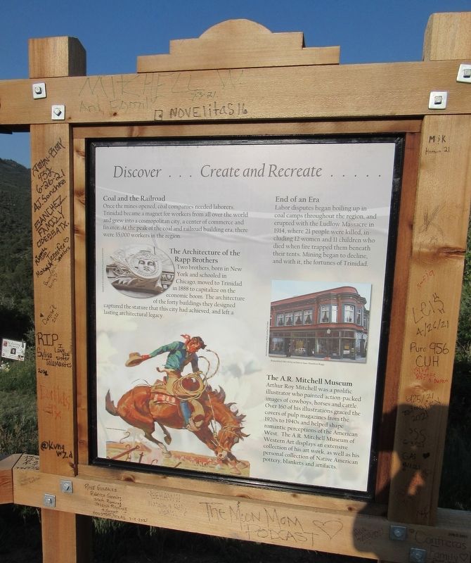
Discover...Create and Recreate (2nd Marker)
| On Interstate 25, 8 miles State Route 72, on the right. |
| On South Front Street at Factory Street (Colorado Highway 6) on South Front Street. |
| Near Interstate 70 Frontage Road (Interstate 70). |
| On Main Street west of South 5th Street, on the right when traveling west. |
| On Main Street west of North 6th Street, on the right when traveling west. |
| On Main Street, on the right when traveling west. |
| On Main Street at South 4th Street, on the right when traveling east on Main Street. |
| On Main Street at South 5th Street, on the right when traveling east on Main Street. |
| On East Main Street (U.S. 160) west of North Ash Street, on the right when traveling west. |
| On West Main Street (U.S. 160) at South Market Street, on the right when traveling east on West Main Street. |
| On Main Street (U.S. 160) at Chestnut Street, on the left when traveling west on Main Street. |
| On West Main Street (U.S. 160) west of North Market Street, on the right when traveling west. |
| On West Main Street (U.S. 160) at South Market Street, on the right when traveling east on West Main Street. |
| On North Market Street north of Main Street (U.S. 160), on the right when traveling south. |
| On Mildred Road north of Main Street (U.S. 160), on the left when traveling north. |
| On East Main Street (U.S. 160) at South Beech Street, on the right when traveling east on East Main Street. |
| On East Main Street (U.S. 160) at South Beech Street, on the right when traveling east on East Main Street. |
| On East Main Street east of South Market Street, on the right when traveling east. |
| On East Main Street (U.S. 160) at North Market Street, on the right when traveling west on East Main Street. |
| On West Main Street at South Maple Avenue, on the right when traveling east on West Main Street. |
| On East Main Street (U.S. 160) east of South Market Street, on the right when traveling east. |
| On West Main Street west of North Market Street, on the right when traveling west. |
| On East Main Street (U.S. 160) east of South Beech Street, on the right when traveling east. |
| On West Main Street (U.S. 160) at North Elm Street, on the right when traveling west on West Main Street. |
| On West Main Street west of North Market Street, on the right when traveling west. |
| On Grand Avenue (Business U.S. 160) at South Main Street, on the right when traveling east on Grand Avenue. |
| On North Main Street at Bauer Avenue, on the right when traveling south on North Main Street. |
| Near State Highway 10, 0.4 miles north of Moorefield Campground Road, on the left when traveling south. |
| On Morrow Point Dam Road, 0.1 miles north of U.S. 50, on the right when traveling north. |
| Near Morrow Point Dam Road, 0.1 miles U.S. 50, on the right when traveling north. |
| On Morrow Point Dam Road, 0.1 miles north of U.S. 50, on the right when traveling north. |
| On East Main Street, on the right when traveling north. |
| On State Highway 52, 0.1 miles north of Interstate 76, on the right when traveling north. |
| Near State Highway 194, 0.1 miles east of County Road 35, on the right when traveling east. |
| Near Colorado Route 194, 0.1 miles east of County Road 35, on the right when traveling east. |
| Near State Highway 194, 0.1 miles east of County Road 35, on the right when traveling east. |
| Near State Highway 194 near County Highway 35. |
| Near State Highway 194 east of County Highway 35. |
| On State Highway 194, 0.3 miles east of County Road 35, on the right when traveling east. |
| Near State Highway 194, 0.1 miles east of County Road 35, on the right when traveling east. |
| On Million Dollar Highway (U.S. 550) 2 miles south of County Highway 30, on the left when traveling north. |
| On Million Dollar Highway (U.S. 550) 2 miles south of County Highway 30, on the left when traveling north. |
| On Million Dollar Highway (U.S. 550) 0.2 miles west of County Highway 20, on the left when traveling east. |
| On Million Dollar Highway (U.S. 550) 0.1 miles south of County Highway 16, on the left when traveling north. |
| On Million Dollar Highway (U.S. 550) 0.1 miles south of County Highway 16, on the left when traveling north. |
| On Million Dollar Highway (U.S. 550) 2 miles south of County Highway 30, on the left when traveling north. |
| On Million Dollar Highway (U.S. 550) 2 miles south of County Highway 31, on the left when traveling north. |
| On Million Dollar Highway (U.S. 550) 2 miles south of County Highway 30, on the right when traveling north. |
| On Million Dollar Highway (U.S. 550) 2 miles south of County Highway 30, on the left when traveling north. |
| On Million Dollar Highway (U.S. 550) 0.1 miles south of County Highway 16, on the left when traveling north. |
| On Colorado Route 9 at County Road 2, on the left when traveling north on State Route 9. |
| On U.S. 24, 0.2 miles west of State Highway 9, on the left when traveling west. |
| On U.S. 24, 0.2 miles west of State Highway 9, on the left when traveling west. |
| On U.S. 285, 0.9 miles south of Packer Lane (County Road 34), on the right when traveling south. |
| On Frontage Road north of County Road 115, on the right when traveling north. |
| Near Colorado 82, 5.6 miles east of County Road 23. |
| Near Colorado 82, 5.5 miles east of County Road 23. |
| Near Colorado 82, 5.6 miles east of County Road 23. |
| On Colorado 82, 5.6 miles east of County Route 23, on the left when traveling east. |
| On Colorado 133, 0.5 miles north of Avalanche Creek Road, on the right when traveling north. |
| On Scenic U.S. 50/287 at State Highway 196, on the right when traveling west on U.S. 50/287Scenic . |
| On Scenic U.S. 50/287 at State Highway 196, on the right when traveling west on U.S. 50/287Scenic . |
| On Scenic U.S. 50/287 at State Highway 196, on the right when traveling west on U.S. 50/287Scenic . |
| Near County Highway 35.25 south of County Highway JJ. |
| On County Highway 35.25 south of County Highway JJ, on the right when traveling south. |
| Near Highway 165 at CanAm Highway (Interstate 25). |
| Near Interstate 25 at milepost 111.6,, 2.5 miles south of Young Hollow Road when traveling south. |
| On Main Street at 6th Street, on the right when traveling west on Main Street. |
| On U.S. 40 at milepost 114.5 at County Highway 52, on the right when traveling east on U.S. 40. |
| On Lincoln Avenue (U.S. 40) just west of 5th Street, on the right when traveling west. |
| On 8th Street (U.S. 286) at Pitkin Avenue, on the right when traveling north on 8th Street. |
| On 8th Street (State Highway 285) north of Pitkin Avenue, on the right when traveling north. |
| On County Highway 9, 0.5 miles north of Highway 2, on the left when traveling north. |
| On County Highway 9, 0.5 miles north of County Highway 2, on the left when traveling north. |
| On County Highway 2, 0.2 miles east of County Highway 52, on the right when traveling east. |
| On Million Dollar Highway (U.S. 550) 1.5 miles north of County Highway 825, on the left when traveling north. |
| On U.S. 550, 0.1 miles west of County Highway 31, on the left when traveling east. |
| On County Highway 2 at County Highway 4, on the right when traveling east on County Highway 2. |
| On County Highway 2, 0.4 miles west of County Highway 52, on the right when traveling east. |
| On County Highway 2, 0.4 miles west of County Highway 52, on the right when traveling east. |
| On Greene Street (County Highway 110) at East 16th Street, on the left when traveling north on Greene Street. |
| On Greene Street at Mineral Street, on the right when traveling north on Greene Street. |
| On Greene Street (County Highway 110) at Mineral Street, on the right when traveling north on Greene Street. |
| On U.S. 550, 0.1 miles west of County Highway 31, on the left when traveling east. |
| On Greene Street (County Highway 110) at West 15th Street, on the left when traveling north on Greene Street. |
| On Greene Street at Mineral Street, on the right when traveling north on Greene Street. |
| On County Highway 2, 0.4 miles west of Highway 52, on the right when traveling east. |
| On County Highway 2, 0.4 miles west of County Highway 52, on the right when traveling east. |
| On County Route 28, 6 miles west of U.S. 385, on the right when traveling west. |
| On County Route 28, 3.3 miles west of U.S. 385. |
| On U.S. 138 just east of 2nd Street, on the right when traveling east. |
| On South Main Street (State Highway 9) at South Park Avenue, on the right when traveling north on South Main Street. |
| Near South Main Street at Washington Avenue. |
| On South Ridge Street at East Lincoln Avenue on South Ridge Street. |
| On South Ridge Street at Washington Avenue on South Ridge Street. |
| Near Gold Run Road south of Glen Eagle Loop. |
323 entries matched your criteria. Entries 201 through 300 are listed above.
⊲ Previous 100 —
The final 23 ⊳