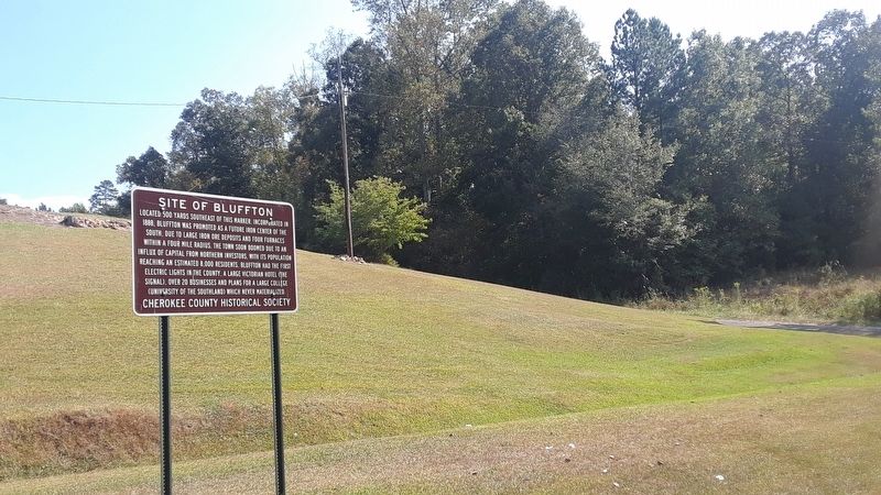
Located 500 yards southeast of this marker. Incorporated in 1888, Bluffton was promoted as a future iron center of the South, due to large iron ore deposits and four furnaces within a four mile radius. The town soon boomed due to an influx of . . . — — Map (db m140001) HM
Named by the Board of Directors
of
Alabama Power Company
to honor
James Mitchell
President 1912-1920
Major modifications to this project were completed in 1985. Three new generating units with a total capacity of 150,000 kilowatts . . . — — Map (db m72486) HM
On January 2, 1944, the State of Alabama granted Hunt Oil Company a permit to drill the A.R. Jackson Well No. 1 at this location near Gilbertown. Hunt Oil Company was owned by the famous oil man, H.L. Hunt of Dallas, Texas. Drilling commenced on . . . — — Map (db m80351) HM
On this site was the "A. R. Jackson Well No. 1". It was
Operated by Hunt Oil Company and was the first
producer in the State of Alabama. This oil well was
completed on February 16, 1944, and produced from
the Selma Chalk formation. It sparked . . . — — Map (db m286132) HM
The Clarke-Washington Electric Membership Corporation was organized near this site on March 2, 1936, by some 83 members from Clarke and Washington Counties. This was the first rural electric cooperative organized in Alabama under an executive order . . . — — Map (db m80356) HM
Side 1
First home of Creek and Choctaw Indians, Jackson’s first pioneer settlers arrived about 1800. The little village was first called Republicville, then Pine Level, before its incorporation by an act of the Mississippi Territory . . . — — Map (db m101591) HM
First village called Republicville. Town laid out in 1815 by Pine Level Land Company and named Pine Level. Incorporated 1816 and renamed Jackson for General Andrew Jackson. First commissioners, David Taylor, David White, Reuben Saffold, Peregrin . . . — — Map (db m101589) HM
Just west of this spot, along Ocre Ave. on a 10-acre tract, was the site of a WWII prisoner of war camp. The camp was one of twenty such labor camps in Alabama. Hdqrs. for the camp was at Camp Shelby in Hattisburg, MS. The camp was opened on . . . — — Map (db m101593) HM
The area from Stave Creek to Jackson Creek was one of sites for the making of salt during the years 1862-64.
Furnaces of native stone were built and salt water from dug wells evaporated by boiling in large kettles.
Amount of salt six hundred . . . — — Map (db m101607) HM
Here was located the large and important Central Salt Works. Official government reports indicate that salt was being mined at this works as early as 1816, but the Indians had obtained salt here for centuries prior to this. During the blockade of . . . — — Map (db m101605) HM
These springs, once called the “celebrated watering place,” believed at one time to have numbered seventeen, all in an area smaller than a baseball diamond, are about ¼ mile south from this point at the headwaters of Tallahatta Creek.
They and . . . — — Map (db m203671) HM
Side 1
In the summer of 1887, a notice was published confirming that the route for the Mobile and West Alabama Railroad would be the Choctaw Corner route. Soon the sounds of building could be heard over the swamp that was the . . . — — Map (db m101601) HM
Side 1
Clay County was formed by an act of the Alabama General Assembly on December 7, 1866. Less than a year later, Ashland was established as the county seat on land donated by Hollingsworth Watts for the construction of a . . . — — Map (db m95087) HM
The forests near Cheaha have been inhabited for thousands of years. Trade
routes brought other native and non-native people to the area searching for
ore, gemstones, venison, hides, furs, honey, beeswax, hickory nut oil, and
other medicinal and . . . — — Map (db m175335) HM
Native Americans were the first to inhabit the area known as
Lineville. The Creek Indian War of 1812, however, resulted in their
removal. The first white settlers here were William and Thomas
Lundie. Their settlement became known as Lundie's . . . — — Map (db m175281) HM
Shortly after the removal of the Creek Nation to Oklahoma during the Trail of Tears, the Alabama Gold Rush began in Cleburne County. The Striplin Gold Mines were constructed in the Carr Creek Placer in approximately 1837. The majority of the . . . — — Map (db m288226) HM
In profound appreciation of the Boll Weevil and what it has done as the Herald of Prosperity this monument was erected by the Citizens of Enterprise, Coffee County, Alabama — — Map (db m30306) HM
This building was built in 1903 with additions in 1916 and 1997. The first freight shipments and passengers came here on the Alabama Midland railroad in 1898 immediately after construction of the roadbed. That was also the year when most of the . . . — — Map (db m30307) HM
Original two-story brick structure built 1903 by Japheth Rawls, developer of some of earliest turpentine plants in Coffee County. Building remodeled 1928 and three-story wings added by Jesse P. Rawls, founder of first electric power system in . . . — — Map (db m30308) HM
George Colbert's stand sat atop the ridge before you. As one of many inns that dotted the Trace between Nashville and Natchez, it provided travelers with food and lodging.
With a Scottish father and Chickasaw mother, George Colbert used his . . . — — Map (db m107260) HM
This monument is to memorialize Chickasaw Chief George Colbert who operated a river ferry, traveler’s stand, and had a home on this Natchez Trace site. Colbert Co. AL was named in his honor. — — Map (db m84706) HM
Levi Colbert, a Chickasaw Chief, operated a stand near here that served Old Trace travelers in the early 1800's. Adjacent to this area was a spring which provided an abundant water supply. — — Map (db m84708) HM
Inns, or stands, provided occasional shelter for travelers along the Natchez Trace. These stands offered flood to eat and food for thought: local news, information, and ideas. The ever-changing mix of diverse populations—whites, American . . . — — Map (db m107263) HM
Wilson Dam
Potential floodwaters that surge downstream on the Tennessee River are collected in Wilson Lake. Then, through carefully controlled releases, the water is gradually sent through the dam. Releasing water through the dam serves . . . — — Map (db m124083)
The Francis Turbine is named for its inventor, James B. Francis, who developed the technology in 1848, while working as the head engineer of the locks and Canals Company in Lowell, Massachusetts.
Francis's design, which improved blade . . . — — Map (db m213304) HM
The Tennessee River has its headwaters in the mountains of Tennessee, Virginia, North Carolina and Georgia. The main stream forms at Knoxville, where the Houston and the French Broad Rivers join. The valley, 41,000 square miles in area, receives . . . — — Map (db m280032) HM
When the bombing of Pearl Harbor suddenly thrust the United States into World War II, President Roosevelt knew that industrial might would be the key to Ally victory. He needed to build thousands of ships, planes, and bombs, and that meant an urgent . . . — — Map (db m106194) HM
The Tennessee Valley Authority is much more than just “a power company.” TVA has been proving this for more than 80 years by powering the region’s progress and managing the natural resources in its care for the greatest public good. . . . — — Map (db m106190) HM
TVA has a rich history of improving quality of life and economic prosperity for people and businesses in the TVA service area. As times have changed, TVA has changed with them, updating and refining its focus to better serve it's enduring mission . . . — — Map (db m106187) HM
During the 19th Century, Muscle Shoals, the shallow but often-flooded rapids of this section of the Tennessee River, impeded navigation, steamboat traffic and agriculture, so the federal government explored the possibility of opening the channel to . . . — — Map (db m105705) HM
Wilson Dam and the TVA System
From the very beginning, TVA knew how important Wilson Dam would be to their operations. In fact, the Wilson Dam area served as the headquarters for TVA's initial agricultural and chemical programs. Today, Wilson . . . — — Map (db m124084)
Wilson Dam is the longest-operating hydroelectric facility in the TVA System and certainly one of the most significant. Built by the U.S. Army Corps of Engineers, primarily to supply power for nitrate production during World War I, Wilson Dam became . . . — — Map (db m106188) HM
With the U.S. entrenched in World War I, President Woodrow Wilson called for the U.S. Army Corps of Engineers to build nitrate plants at Muscle Shoals to produce explosives for the war effort—and a hydroelectric dam to power them both. . . . — — Map (db m106191) HM
Dedicated to civilian defense workers in critical industry for the war. US Army directed construction and production via Air Nitrate Corp. Army Projects here in 1917-1918 required 20,000 workers recruited from across the USA. The great flu-pandemic . . . — — Map (db m138776) HM WM
Center of Industry for new town of Sheffield. Five blast furnaces with 75 ft stacks build 1886~1895 1/2 mile west. Promoted by E. W. Cole and E. Ensley. Iron ore and limestone from Franklin Co., coke from Walker Co. and Virginia used. Hattie Ensley . . . — — Map (db m28428) HM
Side A Prehistoric man arrived in this area bout 10,000 years ago.
Later Indian cultures left many stone artifacts and pottery vessels.
In the 1780s, a French trading post and Indian village were located near the mouth of Spring Creek. . . . — — Map (db m83389) HM
Production Difficulties
Several complications impeded this plant's full operation including its inability to operate at the required pressure of 200 atmospheres at 500-600° C. Most importantly, ammonia synthesis could not be sustained due to . . . — — Map (db m183922) HM
An Experimental Plant
During World War 1, construction of the first ammonia synthesis plant in the U.S. began on this location in October 1917. With plans acquired by American and British espionage, construction of U.S. Nitrate Plant No. 1 . . . — — Map (db m183927) HM
On Jan. 21, 1933 President-elect Franklin Delano Roosevelt addressed an immense crowd at this crossing from his railroad car and promised "to put Muscle Shoals back on the map." He then toured the idle U.S. Nitrate Plant No. 2 and Wilson Dam with . . . — — Map (db m83392) HM
This sculpture is dedicated to the many individuals whose efforts made Sheffield and the Muscle Shoals area the “Hit Recording Capital of the World,” and to those who continue that legacy.
Legend of the Singing River
The . . . — — Map (db m167280) HM
In 1918, during World War I, the U.S. Government built this unique village of 85 bungalows, school, and officers barracks to house personnel at nearby Nitrate Plant No. 1. Prefabricated and standard size materials were used in construction along . . . — — Map (db m88110) HM
Born in Tennessee on October 22, 1818, Charles Womble was the son of Amos and Sarah (Jarman) Womble. By 1850, Womble owned a farm near the town of Frankfort, which he helped select as the new seat of government for Franklin County, Alabama. Involved . . . — — Map (db m192076) HM
Midway was one of the first settlements established in Conecuh County along the Post Road which later became the Old Federal Road. Long serving as a hub for Indian trails branching out to the north, northeast and northwest, the Midway town site once . . . — — Map (db m81277) HM
In the early 1900s, Repton was a bustling railroad town along the Louisville and Nashville Railroad. Among other businesses, it boasted several hotels, banks, stores, a livery stable, cotton gin and the only hospital with a Board Certified . . . — — Map (db m100840) HM
William Stewart Harlan was the manager of Jackson Lumber Company in Lockhart, established in the early twentieth century as a mill town during the booming demand for longleaf yellow pine. Marketed as Dixie Rift Flooring and Dixie Poles and . . . — — Map (db m111256) HM
The Depot In 1900, the L&N Railroad won the right to establish the railroad through this area. The town is named for Henry Opp, who represented L&N in successful legal negotiations. The coming of the railroad consolidated the surrounding areas . . . — — Map (db m39777) HM
The Horse Shoe Lumber Company
E.L. More, president of the A&F Division of the L&N Railroad, arrived in River Falls from Nashville in 1897 to spearhead the construction of a branch line of the L&N. Recognizing a business opportunity in the . . . — — Map (db m154408) HM
Born in South Carolina and orphaned as a young child,
Daniel Dozier arrived in Alabama around 1817. As an adult,
he operated a large farm and grist mill and served as minister
for several area churches. He was a moderator and leader in
the . . . — — Map (db m115007) HM
In 1904, Alabama industrialist Frazier Michel
Douglass, Sr. hired a carpenter from Alexander
City, Alabama to build the Douglass House. The
house is a two-story Queen Anne Victorian and
might be the only home of this architectural type
in . . . — — Map (db m163677) HM
The historic properties within the Luverne Historic District represent seventy years of history from the 1880s to the late 1940s. This district includes the first commercial businesses in downtown and middle to upper middle-class homes. These . . . — — Map (db m172462) HM
In 1946, the McPhillips family brought King Pharr Canning Company, a major vegetable canning operation to Cullman. Led by chairman Julian B. McPhillips of Mobile, and his two sons Julian L. McPhillips and W. Warren McPhillips (returning from Navy . . . — — Map (db m101093) HM
The first family to settle this area in 1832. Married Nancy Stewart Hanby, daughter of Gabriel Hanby, who was one of the original framers of the Alabama Constitution. They became parents of 11 children: 4 sons served in the Confederate Army. At one . . . — — Map (db m201371) HM
The Cullman County Electric Membership Corporation
the first rural electric cooperative in Alabama to provide
electricity. The cooperative, was organized May 25. 1936,
under an executive order signed by President Franklin D.
Roosevelt. Near . . . — — Map (db m295689) HM
Constructed in c. 1900 by G. P. Dowling, the Dowling-Steagall House is a Classical Revival dwelling featuring a full-height portico with Ionic columns and an elaborate door surround. A judge and prominent businessman, G. P. Dowling organized Ozark's . . . — — Map (db m36510) HM
The Cahaba Drug Store once covered this cellar hole. It was operated by Herbert Hudson and J. D. Craig.
On the same lot were T. L. Craig's large family grocery, Coleman's dry goods store, and Fellows' Jewelry.
All these men were related . . . — — Map (db m23008) HM
This cellar was under Joseph Babcock's brick store. During the Civil War the building was used as a commissary.
Babcock's warehouse and cotton shed were located to your right on the bluff overlooking the river. The family home, kitchen, and . . . — — Map (db m23287) HM
A "row" was a 19th century shopping mall. The word was used when a building or block had several similar storefronts arranged in a straight line or row.
This cellar marks the spot where David and Nicholas Crocheron built a large 2 story brick . . . — — Map (db m83509) HM
The grassed over mound of brick before you was once Dallas County's courthouse. This courthouse was built in 1834. It was dismantled prior to 1905 by brick salvagers.
Cahawba was the county seat from 1818 to 1866. This brought a lot of people, . . . — — Map (db m23010) HM
This artesian well was drilled to serve a factory which did not materialize. It was then used to water the grounds, a garden and pastures. In addition, by forcing water through pipes into his $50,000 home, E. M. Perine, a merchant prince, had the . . . — — Map (db m83518) HM
The Crocherons were from Staten Island, New York. Richard Conner Crocheron arrived in town about 1837 to help run the family store. He traveled north for his bride in 1843 after building her this brick home. The back wall adjoined the brick store . . . — — Map (db m22870) HM
1822 - Crocheron's Row
Cahawba's First Shopping Center
This large hole was dug in 1822 to be the
basement beneath Cahawba's first brick
store.
In the 19th century the word "row"
described a building that consisted of . . . — — Map (db m112577) HM
By 1858 many brick stores had been built in Cahaba, so everyone called this the "old brick store." Merchant Sam M. Hill turned the building into one huge dry goods store where shoppers could buy just about anything!
Col. Hill, like most of the . . . — — Map (db m23242) HM
Vine Street was Cahawba's business district. Stores, offices and hotels were tightly packed together along these three blocks. Homes were scattered over an entire square mile. Nearly every house had a yard of one or two acres. — — Map (db m83520) HM
Cahawba's homes were spread over an
entire square mile, many with yards of
one or two acres. That was not the case
here on Vine Street. Offices, stores and
hotels were tightly packed along this
main street. The steamboat landings on
the . . . — — Map (db m112560) HM
Offices, stores and hotels were tightly
packed along this main street. The
steamboat landings on the Alabama
River were just one block away, so this
was prime real estate.
Vine Street was 80 feet wide with brick
sidewalks. A town . . . — — Map (db m274486) HM
In the early 20th century, at least two
small, temporary manufacturing centers
were established on the abandoned
townsite of Cahaba. One was a sawmill
and the other was a mussel harvesting
camp.
W. W. Fox Lumber Company
If you . . . — — Map (db m274847) HM
Anvil used in Selma’s Confederate Arsenal to make armament for Southern forces.
Presented to Sturdivant Museum Association April 1, 1961 by the Southern Railway Company which as the Selma, Rome and Dalton Railroad Company purchased the anvil . . . — — Map (db m37690) HM
At the age of 20, Lewis lost his sight in 1957 from Glaucoma. He learned the
language of braille, other independent living and vocational skills during his
attendance at the Alabama Institute for the Deaf and Blind in Talladega, Alabama. . . . — — Map (db m112363) HM
following the Battle of Selma, April 2, 1865. This occupation protected the hotel from the arson and looting in the first 24 hours that destroyed much of downtown. In the next week Wilson methodically burned the huge military/industrial complex that . . . — — Map (db m80792) HM
Selma’s Water Avenue is one of the finest surviving examples of a 19th century riverfront street in the south. Located here are structures which reflect the architectural trends in commercial buildings from 1830 to 1900.
This was the main . . . — — Map (db m37669) HM
In the late '60s, cousins Randy Owen and Teddy Gentry discovered they shared a common interest in music. Joined by Jeff Cook, they started playing on a regular basis. Working their day jobs and playing any place they could locally in the evenings, . . . — — Map (db m25277) HM
Around 1889-1891 Fort Payne experienced a great industrial boom due to promotion by New England investors who speculated greatly on the area’s mineral deposits. During this period several highly ornate commercial and civic buildings, along with the . . . — — Map (db m261857) HM
Panel 1
1819-1838
(partially broken)
?on - During the middle 1700s, the Cherokee
?south into present day Alabama and
?important village of Willstown. Sequoyah
?kee syllabary while living in the area. In
?e Nation officially . . . — — Map (db m224648) HM
The A. A. Miller Dam Built in 1925 for the first Hydro Electric power in North Alabama. Lower Plaque Memorial cairn erected by William A. (Bill) Wise Grandson of A. A. Miller — — Map (db m182069) HM
Thriving iron ore and coal mining community of early 1900’s established by Colonel John Gordon Battelle five miles north of Valley Head. — — Map (db m61018) HM
Brigadier General Birkett Davenport Fry, CSA
(1822-1891)
In his lifetime General Birkett D. Fry was a cadet at Virginia Military Institute and West Point; 1st Lt. (U.S. Infantry) in Mexican War; lawyer in California; mercenary-soldier of . . . — — Map (db m95112) HM
Settled by A.J. Hall in 1852 and occupied by Confederate troops because of its value as a railroad stop during the War Between the States (1861-65), Canoe was the site of a March 27, 1865 encampment of Union forces. The 1870s brought expansion . . . — — Map (db m72265) HM
Williams Station, Alabama
1866-1897
Creek Indians lived in these parts some 200 years before trains began stopping here in 1866 to leave supplies for a farmer, William Larkin Williams, who lived nearby. Workers, who came first to build . . . — — Map (db m154553) HM
Recognized as “Alabama’s Oldest Bank,” the Bank
of Brewton opened for business on Monday, January 7, 1899. Brewton, Alabama was a prosperous town in the late 1800s. A local resident, Charles Sowell, participated in the flourishing times. A native . . . — — Map (db m239154) HM
Side 1
This tank was used to hold water for the City of Brewton Electric Light and Water Works Fire Protection System and was built circa early 1890's. This location was originally the Blacksher Miller Lumber Company, which became . . . — — Map (db m94172) HM
The Southern Pine Electric Membership Corporation was energized at this site on September 12, 1939, sending electric power flowing into 75 homes and businesses in rural areas of Escambia, Conecuh, Monroe and Baldwin Counties for the first time. The . . . — — Map (db m84372) HM
Truly an Escambia County landmark, Robbins and McGowin Co. organized in March 1897 with the consolidation of the J. I. Robbins and J. G. McGowin Stores, the millinery of Miss L. A. Cunningham, the Blacksher-Miller Commissary, and the J. E. Finlay . . . — — Map (db m130673) HM
Front As railroads were reconstructed following the Civil War, a junction of north-south and east-west lines was established along the Alabama-Florida border near the confluence of Big Escambia Creek and the Conecuh-Escambia River. A . . . — — Map (db m47484) HM
Nichols came to Alabama City in 1894 to supervise construction of the Dwight Manufacturing Company. While serving as the mill's first agent, he planned and began a model mill village and was elected Mayor of Alabama City. — — Map (db m18578) HM
In the fall of 1902, Captain William Patrick Lay, of Gadsden, began construction of a small hydro electric generating plant at the site of Wesson Mill on Big Wills Creek, just southwest of Attalla. The plant was constructed, in Lay’s words, . . . — — Map (db m83730) HM
William Patrick Lay (1853-1940), founder of Alabama Power Company, built his first hydroelectric plant on Big Wills Creek about 2 miles east on Simmons Lane.
Lay purchased the Old Wesson Mill in 1902 and built a small hydroelectric generating . . . — — Map (db m73995) HM
During the year of 1890, Capt. James M. Elliott, Jr., the famed riverboat captain and industrialist, began to draw up plans for a new town about two miles west of Gadsden. Elliott's dream was to develop the town as an industrial center and . . . — — Map (db m156368) HM
This stately Classic Revival house, built c. 1904, was the residence of Colonel Oliver Roland Hood (1867-1951), eminent Gadsden attorney and civic leader. Colonel Hood was one of the three incorporators of Alabama Power Company in 1906 and author of . . . — — Map (db m83732) HM
Dwight Manufacturing Company of Chicopee, Massachusetts selected this site in Alabama City for a cotton mill in 1894. The Mill and the village covering 240 acres was constructed under the direction of Howard Gardner Nichols.
There were 160 . . . — — Map (db m18575) HM
Side A:
In the early 1840’s, John S. Moragne, along with Gabriel and Joseph Hughes, began surveying for a city on the banks of the Coosa River near the settlement of Double Springs. The new city would be located on 120 acres of land at the . . . — — Map (db m39139) HM
Sardis community derived its name from Sardis Baptist Church which was founded in 1882 on another site. There were 20 charter members. They met in a brush arbor until a building was completed in 1887, at this site. The church was a wooden, box frame . . . — — Map (db m156365) HM
Wiley and JM Killingsworth owned and operated the
sawmill located on Boxes Creek just off the Byler
Road. In August 1903, the Killingsworths added a
cotton gin. On October 19, 1903, 6 year-old Sam
Killingsworth was involved in a gin accident in . . . — — Map (db m310091) HM
Belk was known as Beebe in the 19th century. Later, the name
was changed to Mulberry Tank for the water tank located on the
first railroad. It served the steam engine trains as a regular stop
until 1933. The name Belk was established in 1904 due . . . — — Map (db m285017) HM
Town of Berry Established 1883
Thompson Berry settled in this area in the 1840s. Berry devoted
most of his time to raising cattle and farming. As time passed, he
became the owner of a gin and gristmill and several thousand
acres of land . . . — — Map (db m163759) HM
T. A. Wilson built the theater in 1927. Since Red Bay had no electricity at that time, he used a Delco System. Shortly after, electricity became available and he had to switch from Delco to Alabama Power. When he first started in the business, he . . . — — Map (db m83742) HM
The Depot
The Depot, a treasured landmark in the history and growth of Red Bay, was built by Illinois Central Railroad in 1907. The trains provided a lifeline for towns like Red Bay. They brought necessities like sugar, flour, cheese, canned . . . — — Map (db m83746) HM
43585 entries matched your criteria. Entries 101 through 200 are listed above. ⊲ Previous 100 — Next 100 ⊳