2008 entries match your criteria. Entries 101 through 200 are listed.⊲ Previous 100 — Next 100 ⊳
Georgia Historical Society Historical Markers
The Georgia Historical Society has administered GA's historical marker program since 1998, erecting hundreds of new markers. GA's historical marker program was begun by the GA Historical Commission in 1953 and continued by the GA Department of Natural Resources. Their markers are now maintained by the Society. With over 3,000 markers, it is 2nd to Texas in state markers.
Near Cassville-White Road at Shinall Gaines Road NW.
Gen. William Tatum Wofford (June 28, 1824 - May 22, 1884), Cav. Capt. in the Mexican War, Col. and Brig. Gen. in the Confederate Army, is buried here. After Fredericksburg he succeeded to the command of Gen. Thomas R. R. Cobb, who was mortally . . . — — Map (db m30569) HM
On Joe Frank Harris Parkway (U.S. 41) at Cassville Road, on the right when traveling north on Joe Frank Harris Parkway.
May 19, 1864: Butterfield's (3d) Div., 20th A.C. [US], moving S.E., from McDow's, left the road here & marched to the Hawkins Price house, enroute to
Kingston. The 1st & 2nd Divs. [US], on roads W., had the same objective - an erratic move by . . . — — Map (db m13929) HM
On Joe Frank Harris Parkway (U.S. 41) 0.1 miles south of Willow Lane, on the right when traveling south.
Noble Hill Rosenwald School, now known as Noble Hill-Wheeler Memorial Center, built in 1923 as the first standard school for Black children in Bartow County School System. The school closed in 1955 when all schools for Black Children in Bartow . . . — — Map (db m13456) HM
On Joe Frank Harris Parkway (U.S. 41) at Willow Lane NW, on the right when traveling north on Joe Frank Harris Parkway.
May 19, 1864: Skirmishers of Polk's A.C. [CS] withdrew from this ridge E. to Cassville when pressed back by Butterfield's (3d) Div., 20th A.C. [US], from the Hawkins Price house. Battery C, 1st Ohio Lt. Art., supported by 73d Ohio, 19th Mich. & . . . — — Map (db m13941) HM
On Fire Tower Road at Gaddis Road, on the right when traveling east on Fire Tower Road. Reported missing.
On Chapman Hill; a school for boys established Jan. 1854. A large three-story brick bldg. flanked by two-story wings. Burned 1856; rebuilt 1857, destroyed by
Federal forces Oct. 12, 1864. This, & the Methodist Female College 3/4 mi. N.E., were the . . . — — Map (db m13942) HM
On Cassville Road NW (Old Route 41), on the left when traveling south.
In this valley was once situated the proud town of Cassville, begun in July 1833, as the seat of justice for Cass County and soon the center of trade and travel in the region recently comprising the Cherokee Nation. Both the county and town where . . . — — Map (db m12371) HM
On Old Allatoona Road at Allatoona Landing Road, on the left when traveling south on Old Allatoona Road.
Lt. Gen. John B. Hood, Army of Tenn. [CS], while enroute N. from Palmetto, Ga., sent Lt. Gen. A.P. Stewart's Corps to destroy the State R.R. from Big Shanty to the Etowah River. Stewart seized Big Shanty and Acworth on the 3d, and French's Div. was . . . — — Map (db m13935) HM
On Main Street (Georgia Route 293) at Gaston Westbrook Avenue, on the left when traveling north on Main Street.
Named for Joseph Emerson Brown, Gov. of Ga., 1857-1865, U.S. Senator, 1880-1891. Known as Stegall's Station prior to 1889; site of the Bartow Iron Works. May 20, 1864: Gen. Joseph E. Johnston's forces camped here after retreating from Cassville and . . . — — Map (db m10907) HM
On North Main Street SE (Georgia Route 293) at Sandtown Road SE, on the right when traveling west on North Main Street SE.
On Allatoona Creek in this vicinity, a Federal block-house, guarding State R.R. bridge, was garrisoned by Companies E, F, and I, of the 18th Wisconsin Regt. Oct. 5, 1864, while retreating from Allatoona, 2 mi. N., French’s Div. of Stewart’s A.C. . . . — — Map (db m105104) HM
On Covered Bridge Road SW, 0.1 miles west of Covered Bridge-Stilesboro Road SW, on the right when traveling west.
In 1886 the county contracted with Washington W. King, son of freed slave and noted bridge builder Horace King, and Jonathan H. Burke for the construction of this 138-foot bridge. It was adjacent to a mill owned by Daniel Lowry, of which the . . . — — Map (db m8478) HM
On Hall Station Road, 0.1 miles south of Old Hall Station Road, on the right when traveling south.
May 18, 1864. Howard’s 4th Corps leading, & two divs. of Palmer’s 14th [US], moved from Adairsville on this direct road to Kingston. They were halted just outside of Adairsville to await the support of the 15th A. C. of McPherson’s Army of the . . . — — Map (db m40581) HM
On East Railroad Street at Shaw Street, on the left when traveling west on East Railroad Street.
First Decoration, or Memorial Day, was observed in Kingston in late April of 1865, and has been a continuous observance here since that day, the only such record held by any community in this Nation. The first Memorial, or Decoration Day, was . . . — — Map (db m13976) HM
On Kingston Highway (Georgia Route 293) at Martin Circle, on the left when traveling west on Kingston Highway.
May 18, 1864. Lt. Gen. Wm. J. Hardee's A. C. marched from Adairsville on the road parallel to the State R.R. -- turning E. on this rd. to join Polk's & Hood's corps [CS] at Cassville, which had moved on the direct Adairsville - Cassville road. . . . — — Map (db m13962) HM
On Law Road, 1.2 miles north of Kingston Highway (Georgia Route 293), on the left when traveling north.
2.5 mi. N.E. is the antebellum house of Col. Hawkins F. Price; State Senator 1857-1865; Mem. Ga. Secession Convention. A landmark of military operations near Cassville, where both Gen. Daniel Butterfield & Gen. Hooker (20th A.C.) [US] had . . . — — Map (db m13497) HM
On West Main Street at Johnson Street, on the left when traveling east on West Main Street.
Maj. Gen. W.T. Sherman's Headquarters
May 19-23, 1864
Sherman [US] occupied the Hargis house for three days of reorganization of forces in the campaign that ended at Atlanta.
Assuming the Johnston's army [CS] had moved, from Adairsville, . . . — — Map (db m13965) HM
On West Main Street at Elliott Street, on the right when traveling east on West Main Street.
The original church, with another name and at another location, was built in 1845, rebuilt in Kingston in 1854, and dedicated by Rev. Lovick Pierce, a leading preacher of the nation and father of Bishop George F. Pierce. The only church remaining . . . — — Map (db m13537) HM
On Euharlee Road at Macedonia Road, on the right when traveling west on Euharlee Road.
In 1864, a road southward from Wooley's Bridge (Etowah River) crossed the road near this point and ran to Van Wert (Rockmart) and Dallas. This was the route of McPherson's Army of the Tennessee (15th and 16th Corps.), [US] right wing of forces . . . — — Map (db m13926) HM
On Hall Station Road, 1.4 miles north of Kingston Highway (Georgia Route 293), on the left when traveling north.
Ante-bellum plantation and residence of the Rev. Charles Wallace Howard, where he established a private school. May 18, 1864. Hardee's A.C. [CS] moved from Adairsville to Kingston on this road enroute to Cass Station. May 19, the 4th and 14th A.C. . . . — — Map (db m13195) HM
On West Main Street at Church Street, on the right when traveling east on West Main Street.
May 12, 1865
Brig. Gen. Wm. T. Wofford [CS] arranged with Brig. Gen. Henry M. Judah, U.S.A. for the surrender of some 3000 to 4000 Confederate soldiers, mostly Georgians, not paroled in Virginia, N. Carolina, and elsewhere.
During final . . . — — Map (db m13967) HM
On Johnson Street at West Main Street, on the left when traveling north on Johnson Street.
Apr. 12, 1862. James J. Andrews with 18 Ohio soldiers [US] in disguise, & 1 civilian, having seized the locomotive "GENERAL" at Big Shanty (KENNESAW) intending to wreck the State R.R., were forced to side track here & . . . — — Map (db m13963) HM
On Kingston Highway (Georgia Route 293) at Hall Station Road, on the right when traveling west on Kingston Highway.
May 19, 1864. The 4th, followed by the 14th A.C. [US] reached Kingston, 8 a.m. The 4th turned E. to Cassville; a div. of the 14th sent to Gillem's bridge, Etowah River, finding no retreating Confederates, Johnston's forces [CS] were at Cassville, . . . — — Map (db m13961) HM
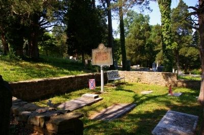
On Johnson Street, 0 miles east of Cemetery Street, on the left when traveling south.
Here sleep, known but to God, 250 Confederate and two Federal soldiers, most of whom died of wounds, disease and sickness in the Confederate hospitals located here - 1862-1864. These men were wounded in the battles of Perryville, Chickamauga, . . . — — Map (db m13980) HM
On Kingston Highway (Georgia Route 293) at Roberson Road, on the left when traveling west on Kingston Highway.
In 1864, this covered structure spanned the Etowah River on the plantation of Andrew F. Woolley, 0.5 mi. S. Next to the river was the Rome - Kingston R.R. discontinued, 1943. May 19, McPherson's Army of the Tenn. (15th & 16th Corps) [US] arched . . . — — Map (db m13925) HM
On Mount Pleasant Road, 1.7 miles Georgia Route 140, on the right when traveling north.
Author of "A Circuit Rider's Wife" and many other books and articles, lived from 1913 until her death in 1935.
The most productive years of her career were spent in a picturesque log cabin, which, according to legend, was once the home of a . . . — — Map (db m13230) HM
On Taff Road, 0.1 miles south of Rockmart Highway (Georgia Route 113), on the right when traveling south.
May 23-24, 1864: The 4th, 20th & two divisions of the 14th corps [US] converged here, from Etowah River crossings at Island Ford, Gillem’s & Milam’s bridges, & moved S.E. up the valley of Raccoon Cr. to Burnt Hickory P.O. (Huntsville).
The . . . — — Map (db m46621) HM
On South Sheridan Street south of East Central Avenue (U.S. 319), on the right when traveling north.
Ben Hill County, created by Act of July 31, 1906 from Irwin and Wilcox Counties, was named for Benjamin Harvey Hill (1823-1882), “one of America’s greatest orators.” A staunch supporter of the administration in the Confederate Senate, after the War . . . — — Map (db m40263) HM
On West Central Avenue (U.S. 319) at North Grant Street (U.S. 129), in the median on West Central Avenue.
Founded at Swan in 1895 by Mr. Philander H. Fitzgerald, lawyer, veteran and publisher of the AMERICAN TRIBUNE of Indianapolis, as a soldiers’ colony in the South. Fitzgerald was settled by Union veterans who, tired of Northern winters, flocked from . . . — — Map (db m40377) HM
On West Suwanee Street, 0 miles west of North Gordon Street, on the left when traveling west.
This was the home of General William Jordan Bush, last survivor of the 125,000 heroes from Georgia who fought for the South. Gen. Bush was born near Gordon, Ga. July 10, 1845, and died here Nov. 11, 1952. In the War Between the States he was a . . . — — Map (db m40168) HM
On West Central Avenue (U.S. 319) at Grant Street (U.S. 129), in the median on West Central Avenue.
On May 4, 1865, Jefferson Davis arrived in Washington, Georgia (178 miles NE of the Park), where he performed his last duties as President of the Confederate States of America. Shortly thereafter, with a small staff and escort, he departed enroute . . . — — Map (db m40378) HM
On Bethlehem Church Road, 0.1 miles south of Broom Road, on the left when traveling south.
Ozias Primitive Baptist Church was constituted July 14, 1832. Elders Wilson Conner and John Martial were the Presbytery. Members were John McDonald, Randall McDonald, Elijah Hunter, Penelope Hunter, Catherine McCall, Mary McDonald, Elizabeth . . . — — Map (db m57153) HM
On South Davis Street (U.S. 129) at East Washington Avenue, on the right when traveling north on South Davis Street.
Berrien County, created by Act of Feb. 25, 1856, was named for John MacPherson Berrien, “the American Cicero,” who was born Aug. 23, 1781 and died Jan. 1, 1856. He was Judge of the Eastern Circuit, U.S. Senator and U.S. Attorney General. . . . — — Map (db m40122) HM
On North Main Street (U.S. 129) at Flat Creek Church Road, on the left when traveling north on North Main Street. Reported missing.
Flat Creek Mills was a trading post and election precinct many years before the present Berrien County was created in 1856. Officers of the new county were sworn in here, and there being no court house, the first Inferior Court was held here in the . . . — — Map (db m50534) HM
On South Davis Street (U.S. 129) at East Washington Street, on the right when traveling north on South Davis Street.
In the summer of 1836, a company of militia under Capt. Levi J. Knight of near Ray City was sent to protect the settlers from marauding Indians on their way to join the Seminoles in Florida. When a party of Indians plundered the plantation of . . . — — Map (db m40123) HM
On North Davis Street (U.S. 129) at East Marion Street (Georgia Route 76), on the right when traveling north on North Davis Street.
The Old Coffee Road, earliest vehicular and postal route of this section, running southwestward from the Ocmulgee River to the Florida Line, passed through today’s Lax, Nashville, Cecil, Barwick and Thomasville. The thoroughfare was opened by . . . — — Map (db m40124) HM
Governor of Georgia (1877-1882), U.S. Congressman (1853-1855), U.S. Senator (1883-1894), Major U.S. Army in the Mexican War, Brigadier-General in the Confederate Army, Alfred Holt Colquitt is buried here. Born in Walton County, Georgia, April 20, . . . — — Map (db m25393) HM
On Anthony Road at Stephens Street, on the right when traveling east on Anthony Road.
Ballard-Hudson Senior High School was built in 1949 as the only high school in Macon for African Americans in grades nine through twelve. The school
represents the merger of two schools: Ballard High School, a private school with roots in Lewis . . . — — Map (db m38198) HM
On Ocmulgee National Park Road, 0.2 miles Emery Highway (Georgia Route 80), on the right when traveling south.
On July 30, 1864, Gen. Stoneman with 2,500 cavalry crossed Walnut Creek & placed his cannon on a ridge on the Dunlap farm. He attacked Macon to capture the gold in the Confederate Depository; to destroy the Armory, Arsenal & Laboratories, the . . . — — Map (db m98661) HM
On Mulberry Street at 2nd Street, on the right when traveling west on Mulberry Street.
Bibb County was created by Act of Dec. 9, 1822 from Houston, Jones, Monroe and Twiggs Counties. It was named for Dr. William Wyatt Bibb (1781-1820) of Elbert County. Dr. Bibb, physician, legislator, Congressman, Senator, was appointed Governor of . . . — — Map (db m44892) HM
Sidney Lanier, poet, linguist, musician, mathematician & lawyer, was born in this cottage, Feb. 3, 1842. He graduated from Oglethorpe Univ. then at Milledgeville, served as a private in the Confederate Army and was captured while commanding a . . . — — Map (db m664) HM
On Joe Tamplin Industrial Boulevard, 0.1 miles west of Riggins Mill Road, on the right when traveling west.
Camp Wheeler was an army training camp during 1917-19 and 1940-46. It was named for Joseph Wheeler (1836-1906), Confederate Lt. Gen. who was born in Augusta, Ga.
The tent camp was established in 1917 after efforts of local businessmen brought . . . — — Map (db m12415) HM
On Shurling Drive, 0 miles west of Gray Highway (U.S. 129), on the right when traveling west.
Founded in October 1899 by the Reverend E. K. Love under the auspices of the Missionary Baptist Convention of Georgia, Central City College served as a co-educational institution of learning for African-American students at both the high school and . . . — — Map (db m23065) HM
On Walnut Street, 0 miles east of 2nd Street, on the right when traveling east.
The Reverend Lot Jones, while on a missionary tour of Georgia, founded Christ Episcopal Church on March 5, 1825. It was the first congregation organized in Macon. On December 26, 1826, the Georgia General Assembly enacted, “that Christopher B. . . . — — Map (db m49579) HM
On D. T. Walton Sr. Way at Poplar Street on D. T. Walton Sr. Way.
The Macon City Hall, built in 1837 for the Monroe Railroad & Banking Co. and since remodeled, served from Nov. 18, 1864 till March 11, 1865 as temporary Capitol of Ga. Here Gov. Brown had his office and convened the last session of the Ga. . . . — — Map (db m60529) HM
On College Station Drive, 0 miles south of Columbus Road, on the right when traveling south. Reported missing.
Colonial Trading Path or “Lower Path” joined the heart of the Creek Nation on the Chattahoochee River to the English Trading Post in Ocmulgee Old Fields, now Ocmulgee National Monument. Here the chief towns of the ancient Creek Confederacy stretched . . . — — Map (db m206104) HM
On Thursday, April 26, 1866, the graves of Confederate soldiers in Rose Hill Cemetery and in the cemetery at 7th and Cherry Streets were decorated with flowers by the members of the Ladies’ Memorial Association, organized in March 1866 with Mrs. . . . — — Map (db m37572) HM
On Vineville Avenue (U.S. 41) at Vista Circle, on the right when traveling north on Vineville Avenue.
Approximately 100 feet south of this point stood the Confederate States Central Laboratory. Erected between 1862 and 1865, this laboratory-factory complex spread over 145 acres purchased December 2, 1862. It was intended as permanent facility and . . . — — Map (db m168256) HM
On Willie Smokie Glover Drive, on the right when traveling west. Reported missing.
In May 1539 Hernando de Soto landed in Florida with over 600 people, 220 horses and mules, and a herd reserved for famine. Fired by his success in
Pizarro's conquest of Peru, De Soto had been granted the rights, by the King of Spain, to explore, . . . — — Map (db m27272) HM
On 3rd Street, 0 miles north of Cherry Street, in the median.
After a revival of interest in camellias, the first public Camellia Show in the U.S. was held Feb. 5, 1932 at Burden-Smith & Co. At the suggestion of Henry T. Conner, immediately after the show, the Azalea and Camellia Soc. of America, forerunner of . . . — — Map (db m49669) HM
On Woolfolk Street at Smith Street, on the right when traveling west on Woolfolk Street.
Fort Hawkins was established at this site in 1806 on the eastern bank of the Ocmulgee River at the border of the Muskogee Creek Nation. The location was chosen by the fort’s namesake, Benjamin Hawkins, who served as the U.S. Agent for Indian Affairs . . . — — Map (db m59564) HM
Edward D. Tracy, Jr., was born in Macon, Georgia, on Nov. 5, 1833. His father served as Macon’s second Mayor (1826-1828), a Judge of Superior Court, and hosted General Lafayette during his visit to Macon in 1825. The younger Tracy graduated from the . . . — — Map (db m25388) HM
On Mulberry Street, 0 miles east of 2nd Street, in the median.
On May 4, 1865, Jefferson Davis arrived in Washington, Georgia (100 miles NE), where he performed what proved to be his last duties as President of the Confederate States of America. Shortly thereafter, with a small staff and escort, he departed . . . — — Map (db m25409) HM
This house, built in 1853 by Judge Asa Holt, was struck by a cannon ball from Gen. Stoneman's guns in East Macon during the Battle of Dunlap's Hill. July 30, 1864, when the Union army tried unsuccessfully to take Macon. The ball, now in the . . . — — Map (db m23376) HM
On Coleman Avenue at College Street, on the right when traveling east on Coleman Avenue.
Founded in Penfield, Georgia, January 14, 1833, as Mercer Institute, Mercer University, the “oldest child” of the Georgia Baptist Convention, has been the chief source of Baptist ministerial and lay leaders through the years. Among the . . . — — Map (db m44946) HM
On Mulberry Street at 1st Street, on the right when traveling west on Mulberry Street.
This church, organized in 1826, is on land deeded to it by the Georgia Legislature in the same year. In 1828, the first church building in Macon was erected on this site. The first appointed pastor was Thomas Darley, who had been ordained by Bishop . . . — — Map (db m29210) HM
On College Street at Georgia Avenue, on the left when traveling north on College Street.
On December 23, 1836, the Legislature of the State of Georgia chartered The Georgia Female College. The first class graduated July 26, 1840. In 1843, the name was changed to Wesleyan Female College; in 1919 to Wesleyan College.
The oldest . . . — — Map (db m54616) HM
On Poplar Street at New Street, on the right when traveling east on Poplar Street.
The history of Roman Catholicism in Macon dates to a visit in 1829 by Bishop John England of the Diocese of Charleston and the subsequent migration of Irish Catholic families in the 1830s. In 1841 Macon's Catholics received their first pastor, . . . — — Map (db m22189) HM
On Ward Street, 0.1 miles north of Vineville Avenue (U.S. 41), on the right when traveling north.
This African-American parish began in 1888 and was named St. Peter Claver in 1903, in honor of the Patron Saint of Negro Missions. The current school, convent, and rectory were built here after the parish moved from Pio Nono Avenue in 1913. The . . . — — Map (db m25123) HM
On Ocmulgee National Park Road, 0.2 miles Emery Highway (U.S. 80), on the right when traveling south.
The only battles fought at Macon took place here. Twice the Federals attacked Macon, emplanting their cannon on this farm, and twice they were repulsed. In the first attack under Gen. Stoneman on July 30, 1864, they shelled Macon from 10 A.M. until . . . — — Map (db m44995) HM
On Washington Avenue (U.S. 41) at High Place, on the right when traveling east on Washington Avenue.
This church was founded in 1826 as the city’s first Baptist congregation. It was first located at the site of the present Bibb County Courthouse. The fourth and final move, to this site, occurred in 1883 and the current building was dedicated in . . . — — Map (db m23046) HM
On Mulberry Street at 1st Street, on the right when traveling east on Mulberry Street.
Organized as the Presbyterian Church of Macon on June 18, 1826, by the Rev. Benjamin Gildersleeve and the Rev. Joseph C. Stiles, the church dedicated this house of worship, its third, on September 19, 1858, at the close of the ministry of the Rev. . . . — — Map (db m44944) HM
On Mulberry Street, 0 miles west of 1st Street, in the median.
On Nov. 15, 1864, after destroying Atlanta, Maj. Gen. W.T. Sherman, USA, began his March to the Sea. His army (650,000 infantry and 5,500 cavalry) moved in two widely separated wings. The Right Wing (15th and 17th Corps), Maj. Gen. O. O. Howard, . . . — — Map (db m25408) HM
On Mulberry Street, 0 miles west of New Street, in the median.
In July, 1864, Union forces under Maj. Gen. W.T. Sherman, USA, closed in on Atlanta. Finding its fortifications “too strong to assault and too extensive to invest,” Sherman sought to force its evacuation by sending Maj. Gen. Geo. . . . — — Map (db m44555) HM
On Mulberry Street, 0 miles west of 3rd Street, in the median.
On March 22, 1865, the Cavalry Corps, Military Division of the Mississippi [US], Bvt. Maj. Gen. James H. Wilson, USA, left the Tennessee River near Florence, Ala., and marched south to Selma to destroy its arsenals and foundries. On April 10th, . . . — — Map (db m25380) HM
This County, created by an act of the Georgia Legislature
July 30, 1912, is named for Chief Justice Logan E. Bleckley, of
the Georgia Supreme Court, one of the greatest jurists in the
history of this State. Born in Rabun County in 1827, he . . . — — Map (db m47553) HM
On Golden Isles Highway (U.S. 23) 0.3 miles north of Coley Station Road (Georgia Route 112), on the right when traveling north.
Evergreen Baptist Church, built in 1844, was split off from old Mt. Horeb Baptist Church, constituted October 15, 1809, which stood at or near the site of the Centenary Methodist Church. On February 14, 1844, the congregation and pastor found . . . — — Map (db m40312) HM
On Longstreet Church Road, 0.5 miles south of Broadhead Road, on the left when traveling north.
Longstreet Methodist Church was organized around 1812 and the original building is still in use. Land for the church was given by Charles Walker, one of the five sons of George Walker, Revolutionary soldier and early settler. The sons built on a . . . — — Map (db m40313) HM
On Dykes Street SE (Georgia Route 26) north of 8th Street SE, on the right when traveling north.
This highway coincides closely with a segment of a noted east-west Indian route called the Lower Uchee Path. Beginning at Old Town on the Ogeechee, the trail led this way by Carr’s Shoals, on the Oconee, above Dublin, thence via Cochran, . . . — — Map (db m40267) HM
On U.S. 82, 0.4 miles west of Petty Crossing Road, on the right when traveling east.
This ridge, interrupted only by major streams, extends south from the Altamaha River in Georgia to the Santa Fe River in Florida, a distance of 130 miles. It is an ancient barrier beach formerly many miles off-shore in the sea which covered this . . . — — Map (db m12423) HM
On Main Street (U.S. 301) near Brantley Street, on the right when traveling north.
This County, created by Act of the Legislature Aug. 14, 1920, is named for Benjamin D. Brantley. It is said that the old B. & W. Railroad, which was partly destroyed, marked the most southern point of advance of Sherman's Army. Among the first . . . — — Map (db m24045) HM
On Beasley Road (County Route 79) 0 miles Grooverville Road (County Route 275), on the left when traveling north.
This church had its beginning in 1832, on the plantation of William H. Ramsey, about 4½ miles Southwest of here. There being no Methodist services in the vicinity at the time he and his family moved to this area. Mr. Ramsey built a brush-arbor . . . — — Map (db m10025) HM
Near Liberty Church Road (County Route 94) 0 miles north of Grooverville Road (County Route 275), on the right when traveling west.
Between 1837 - 1841 the Baptists in this section were stirred on Missions, Sunday Schools and ministerial support. In 1841 the Ocklochnee anti-Missionary Baptist Assn. passed a ruling to dismiss members believing in the “new fangled . . . — — Map (db m10172) HM
On Campground Road, 0 miles east of Adel Highway (Georgia Route 76), on the left when traveling south.
The first Camp Meeting was held on this site in 1828 by a "few scattered Methodists" before any Methodist Church in the area was organized. William Hendry, William Blair and Hamilton W. Sharpe, as a committee, selected the site. Rev. Adam Wyrick was . . . — — Map (db m14761) HM
On Adel Highway (Georgia Route 76) at Coffee Road, on the right when traveling north on Adel Highway.
The Old Coffee Road, first vehicular and postal route of this area, passed here running southwestward from the Ocmulgee River via today's Lax, Nashville, Cecil, Barwick, and Thomasville to the Florida line above Tallahassee. The thoroughfare was . . . — — Map (db m14751) HM
On Radford Road (County Route 114) 0.8 miles west of Madison Highway (Georgia Route 333), on the left when traveling west.
Columbia Primitive Baptist Church was formally constituted on the first Sunday in October, 1833, after serving as an arm of Bethany Church more than a year. Moses Dees was the first delegate from Columbia to the annual meeting of the mother church, . . . — — Map (db m14749) HM
On Bethel Church Road, 1.5 miles south of Georgia Route 122, on the left when traveling south.
Bethel Primitive Baptist Church, the second Baptist Church to be organized in the area of old Lowndes County, was constituted September 2, 1826. The
organizing Presbytery were: Elders Benjamin Manning. Matthew Albritton and Henry Melton, with . . . — — Map (db m51514) HM
On Bethlehem Church Road at Grooverville Road, on the left when traveling south on Bethlehem Church Road.
Bethlehem Primitive Baptist Church about 4 miles Southwest of here, was constituted November 29, 1834. The charter members included: William T.
Rushing, his wife, Belinda; Asa Geiger, his wife, Nancy; William Jones, his wife, Elizabeth; James . . . — — Map (db m14747) HM
On East Screven Street (U.S. 84) at South Court Street (U.S. 221), on the right when traveling west on East Screven Street.
This county created by Act of the Legislature Dec. 11, 1858, is named for Preston Smith Brooks, zealous defender of States Rights. Born in S.C. Aug. 6, 1819, Brooks served in the Mexican War & in Congress. He died June 27, 1857. The first County . . . — — Map (db m26977) HM
On South Court Street (U.S. 221) at West Screven Street (U.S. 84), on the right when traveling south on South Court Street.
In August 1864, during the American Civil War, four men were executed in Brooks County, Georgia, for conspiring to plot a slave insurrection. The conspirators – led by a local white man, John Vickery, and three slaves named Nelson, George, and . . . — — Map (db m40368) HM
On Moultrie Highway (Georgia Route 333) at Coffee Road, on the left when traveling south on Moultrie Highway.
The Old Coffee Road, earliest vehicular and postal route of this area, crossed here, leading southwestward from the Ocmulgee River via today's Lax,
Nashville, Cecil, Barwick and Thomasville to the Florida Line. The thoroughfare was opened by . . . — — Map (db m14763) HM
On Thomasville Road (U.S. 84) 0 miles west of South Laurel Street, on the right when traveling east.
In this cemetery, during the last year of the War Between the States, a number of Confederate soldiers, 17 of them unknown, were buried. Memorial services for these soldiers were held as early as 1869. In 1871, on Memorial Day, April 26, a group of . . . — — Map (db m26978) HM
On Nov. 15, 1864, after destroying Atlanta and cutting his communications with the North, Maj. Gen. W. T. Sherman, USA, began his destructive Campaign for Savannah -- the March to the Sea. He divided his army [US] into two wings. The Left Wing (14th . . . — — Map (db m11957) HM
On U.S. 80 near U.S. 280, on the right when traveling south.
The highway northward is the Old River Road, one of the earliest routes west of the Ogeechee and a leading way from Savannah to Georgia's western frontier. It followed an old Indian trial [sic] along the Ogeechee to a point west of Bartow, . . . — — Map (db m12474) HM
On U.S. 280 at Black Creek Church Road, on the left when traveling south on U.S. 280.
On Dec. 6, 1864, the 15th Corps (US), the extreme right of Gen. Sherman's army on its destructive March to the Sea, camped near Jenk's Bridge on Great Ogeechee River, east of Blitchton. On the 7th, Oliver's brigade was sent in advance of Hazen's . . . — — Map (db m11939) HM
On Belfast-Keller Rd, on the left when traveling west.
This church, the oldest congregation in lower Bryan County, was certified by the Presbytery of Georgia in 1830. Its founders included rice planters on Bryan Neck, among them Thomas Savage Clay, Richard James Arnold and George Washington McAllister. . . . — — Map (db m18648) HM
On South College Street (Georgia Route 67) near Courthouse Street, on the right when traveling north.
This County created by Act of the Legislature Dec. 19, 1793, is named for Jonathan Bryan, Revolutionary patriot and member of the Executive Council in 1777. The "lost town" of Hardwick on the Ogeechee River was the first temporary County Site. Laid . . . — — Map (db m14952) HM
On Ford Avenue (State Highway 144) at Coastal Highway (U.S. 17), on the right when traveling east on Ford Avenue.
On May 10, 1754 GEORGE TOWN was established at the "Elbow" of Great Ogeechee River, eight miles east. In February, 1755, Gov. Reynolds, dissatisfied with Savannah as a capital and as a port, chose this new site because it has a . . . — — Map (db m8364) HM
On U.S. 144 at State Road 67, on the left when traveling south on U.S. 144.
Near here, on the West bank of the Ogeechee River, Fort Argyle was built in 1733, to command one of the main passes by which enemy Indians had recently invaded South Carolina, and to give protection to the settlers of Savannah from anticipated raids . . . — — Map (db m29523) HM
On Fort McAllister Road (State Highway 144 Spur) near Bryan Neck Road (State Highway 144), on the right when traveling east.
East 4.5 miles, on Great Ogeechee River, Fort McAllister was built 1861-62 to guard the "back door" to Savannah. During 1862-63, it repulsed 7 attacks by armored vessels, some mounting 15-inch guns. Dec. 13, 1864, its small garrison of 230 . . . — — Map (db m29452) HM
On Ford Avenue (State Highway 144) at Coastal Highway (U.S. 17), on the right when traveling east on Ford Avenue.
Situated at Genesis Point, 10 miles east on the right bank of the Great Ogeechee River below the "lost town" of Hardwick, this fort was the right of the exterior line designed for the defense of Savannah. It denied the use of the river to Union . . . — — Map (db m8387) HM
Dec. 1864. Fort McAllister, built 1861-62 to close the Great Ogeechee River to enemy ships, mounted 11 siege guns, 12 field pieces and 1 10-inch mortar. Below it, piles and torpedoes obstructed the channel. As the Union forces neared Savannah, the . . . — — Map (db m16103) HM
On July 1st and 29th, 1862, the fort was shelled by Union gunboats and on Nov. 19th by the ironclad "Wissahickon" and two escort craft. Hit below the waterline, "Wissahickon" withdrew after firing 17 11-inch and 25 other shells. The escorts withdrew . . . — — Map (db m16102) HM
On State Highway 144 at County Route 67, on the right when traveling west on State Highway 144.
On Dec. 6, 1864, the 15th Corps (US), Maj. Gen. P. J. Osterhaus, USA the extreme right of Gen. Sherman's army on its destructive March to the Sea, camped near Jenk's Bridge, on Great Ogeechee River east of Blichton. On the 7th, Oliver's brigade of . . . — — Map (db m15812) HM
On Fort McAllister Road (State Highway 144 Spur) near Bryan Neck Road (State Highway 144), on the right when traveling east.
On Dec. 12, 1864, the 3rd Cavalry Division [US], Brig. Gen. J. L. Kilpatrick, USA, covering the right rear of Gen. Sherman's army which was then closing in on Savannah, crossed the Great Ogeechee River near Fort Argyle and the Canoochee River near . . . — — Map (db m29458) HM
In July, 1862, the CSS "Nashville", Capt. Baker, ran the Union blockade and entered Savannah via Wilmington River with a cargo of arms. Loaded with cotton for Europe, she attempted to escape via Ossabaw Sound. Thwarted by the vigilance of the . . . — — Map (db m164870) HM
On U.S. 301 at Adabelle Road, on the right when traveling south on U.S. 301.
In 1870 a group of Croatan Indians migrated from their homes in Robeson County North Carolina, following the turpentine industry to southeast Georgia. Eventually many of the Croatans became tenant farmers for the Adabelle Trading Company, growing . . . — — Map (db m14156) HM
On Arcola Road (County Route 582) at McElveen Cemetery Road (County Route 327), on the left when traveling south on Arcola Road.
In the old McElveen Cemetery, one-third of a mile northeast of this marker, is the grave of John Abbot, pioneer naturalist of Georgia. Abbot was born in London June 1, 1751, and in early youth became devoted to the study and delineation of insects. . . . — — Map (db m24018) HM
On Statesboro Highway (U.S. 301) near Old River Road North, on the right when traveling south.
The highway crossing here is the Old Savannah Road, one of the earliest vehicular routes west of the Ogeechee River. It led from Savannah to the Rock Landing on the Oconee, to the south of the present Milledgeville. There it connected with the main . . . — — Map (db m11101) HM
On Old River Road North (County Route 474) at Jones Ln Memorial Highway (U.S. 301), on the right when traveling west on Old River Road North.
Three miles east of this point, on the old River Road, is located Union Meeting House (Methodist), the oldest church in Bulloch county, and one of the oldest churches in Georgia remaining continuously active since its organization. Title was . . . — — Map (db m10890) HM
On Georgia Route 119 at Turner Road, on the left when traveling west on State Route 119.
The highway crossing here is the Old River Road, one of the earliest white man’s routes west of the Ogeechee. The State authorized the opening of this portion of the old thoroughfare in 1777. It followed the course of an Indian trail that led to the . . . — — Map (db m54031) HM
On N. Main Street (U.S. 301) at Courtland Street, on the right when traveling south on N. Main Street.
Bulloch County was created by Act. of Feb. 8, 1776 from Bryan and Screven Counties. Originally, it contained part of Evans, Candler, Emanuel and Jenkins Counties. It was named for Archibald Bulloch (1730-1777), Revolutionary leader, elected Pres. of . . . — — Map (db m10401) HM
2008 entries matched your criteria. Entries 101 through 200 are listed above. ⊲ Previous 100 — Next 100 ⊳