By James Hulse, October 31, 2021
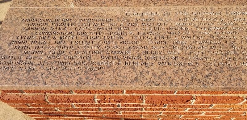
Closeup of the left side of the lower flat marker - Highway Marker
| On County Highway 1230 at County Highway 2000, on the left when traveling west on County Highway 1230. |
| On West 2nd Street, on the right when traveling west. |
| On U.S. 66, on the right when traveling east. |
| On West 2nd Street just west of North Pioneer Road, on the left when traveling west. |
| On West 2nd Street, on the right when traveling west. |
| On U.S. 66, on the left when traveling east. |
| On U.S. 66, on the left when traveling east. |
| On U.S. 66, on the left when traveling east. |
| On West 3rd Street (Business Interstate 40) west of North Pioneer Road, on the right when traveling west. |
| On West 3rd Street (Business Interstate 40) west of Pioneer Road, on the right when traveling west. |
| On U.S. 66, on the left when traveling east. |
| On U.S. 66, on the left when traveling east. |
| On North Jefferson Avenue at West Broadway Avenue, on the right when traveling south on North Jefferson Avenue. |
| On U.S. 66 near North Pioneer Road, on the left when traveling east. |
| On I-40 3 miles north of North County Road 1760. |
| On South Sheb Wooley Street south of West 3rd Street, on the right when traveling south. |
| On East Main Street (U.S. 66). |
| On East Main Street (U.S. 66). |
| On Bank X Road at Bank 19 Road on Bank X Road. |
| Near North Broadway Street at East Poplar Avenue, on the right when traveling south. |
| On North 4th Street (U.S. 283) at Elm Avenue, on the right when traveling north on North 4th Street. |
| On Old Route 66 0.2 miles west of Texas Avenue, on the right when traveling west. |
| On East Central Boulevard (State Highway 9) 0.3 miles east of Southeast 7th Street, on the right when traveling west. |
| Near East Central Boulevard (State Highway 9) 0.3 miles east of Southeast 7th Street. |
| On East Central Boulevard 0.3 miles east of Southeast 7th Street (State Highway 9), on the right when traveling west. |
| On West Broadway Street 0.1 miles west of Southwest 2nd Street, on the right when traveling west. |
| On East Central Boulevard (U.S. 62) 0.3 miles east of Southeast 7th Street, on the right when traveling west. |
| On East Broadway Street at East 2nd Street, on the right when traveling east on East Broadway Street. |
| On East Central Boulevard (State Highway 9) 0.3 miles east of Southeast 7th Street, on the right when traveling west. |
| Near E Central Boulevard. |
| On East Central Boulevard (U.S. 62) 0.3 miles east of Southeast 7th Street, on the right when traveling west. |
| On East Central Boulevard (State Highway 9) 0.3 miles east of Southeast 7th Street, on the right when traveling west. |
| On West Broadway Street at Southwest 2nd Street, on the left when traveling west on West Broadway Street. |
| On East Central Boulevard (U.S. 62) 0.3 miles east of Southeast 7th Street, on the right when traveling west. |
| On East Central Boulevard (U.S. 62) 0.3 miles east of Southeast 7th Street, on the right when traveling west. |
| On South 1st Street 0.2 miles north of SW Oklahoma Avenue, on the left when traveling north. |
| On East Central Boulevard (U.S. 62) 0.3 miles east of Southeast 7th Street, on the right when traveling west. |
| On West Broadway Street at North 1st Street (U.S. 281), on the right when traveling west on West Broadway Street. |
| On E. Central Boulevard at Wells Drive, on the right when traveling west on E. Central Boulevard. |
| On East Central Boulevard 0.3 miles east of Southeast 7th Street, on the right when traveling west. |
| On East Central Boulevard (State Highway 9) 0.3 miles east of Southeast 7th Street, on the right when traveling west. |
| Near East Central Boulevard (State Highway 9) 0.3 miles east of Southeast 7th Street. |
| On East Central Boulevard (U.S. 62) 0.3 miles east of Southeast 7th Street, on the right when traveling west. |
| On East Central Boulevard (U.S. 62) 0.3 miles east of Southeast 7th Street, on the right when traveling west. |
| On West Broadway Street at South 1st Street, on the left when traveling west on West Broadway Street. |
| On East Central Boulevard (U.S. 62) 0.3 miles east of Southeast 7th Street, on the right when traveling west. |
| On East Central Boulevard (State Highway 9) 0.3 miles east of Southeast 7th Street, on the right when traveling west. |
| On East Central Boulevard (State Highway 9) 0.3 miles east of Southeast 7th Street, on the right when traveling west. |
| Near E Central Boulevard. |
| On East Central Boulevard (State Highway 9) 0.3 miles east of Southeast 7th Street, on the right when traveling west. |
| On East Central Boulevard (U.S. 62) 0.3 miles east of Southeast 7th Street, on the right when traveling west. |
| On West Broadway Street at Northwest 3rd Street, on the right when traveling west on West Broadway Street. |
| On U.S. 281 0.1 miles north of Wichita Lane, on the right when traveling north. |
| Near East Central Boulevard (State Highway 9) 0.3 miles east of Southeast 7th Street. |
| On East Central Boulevard (U.S. 62) 0.3 miles east of Southeast 7th Street. |
| On East Central Boulevard (U.S. 62) 0.3 miles east of Southeast 7th Street, on the right when traveling west. |
| Near E Central Boulevard close to Wells Drive. |
| Near East Central Boulevard. |
| On East Central Boulevard (U.S. 62) 0.3 miles east of Southeast 7th Street, on the right when traveling west. |
| On East Central Boulevard (U.S. 62) 0.3 miles east of Southeast 7th Street, on the right when traveling west. |
| Near East Central Boulevard. |
| On East Main Street at Northeast 3rd Street, on the right when traveling west on East Main Street. |
| On West Broadway Street at South 1st Street (U.S. 281), on the left when traveling west on West Broadway Street. |
| On East Central Boulevard (State Highway 9) 0.3 miles east of Southeast 7th Street, on the right when traveling west. |
| On East Central Boulevard (U.S. 62) 0.3 miles east of Southeast 7th Street, on the right when traveling west. |
| On West Broadway Street 0.1 miles Southwest 2nd Street, on the right when traveling west. |
| On East Central Boulevard (U.S. 62) 0.3 miles east of Southeast 7th Street, on the right when traveling west. |
| Near East Central Boulevard (State Highway 9) 0.3 miles east of Southeast 7th Street. |
| On North Main Street north of 4th Street, on the right when traveling north. |
| On Hazlett Street (State Highway 9) at Mopope Street, on the left when traveling south on Hazlett Street. |
| On U.S. 281 0.5 miles south of Old U.S. 66, on the left when traveling south. |
| On State Highway 152 1.5 miles east of U.S. 281, on the right when traveling east. |
| On Old U.S. 66 east of South Coleman Avenue, on the right when traveling east. |
| On State Highway 58 0.3 miles south of 2nd Street, on the right when traveling north. |
| On Old 66 Road 0.5 miles west of Oklahoma Highway 58, on the right when traveling west. |
| Near Unnamed Driveway 0.1 miles north of Cache Meers Road (State Highway 115). |
| On Corral Road at Randolph Road, on the right when traveling west on Corral Road. |
| On Corral Road at Randolph Road, on the right when traveling west on Corral Road. |
| On Corral Road at Randolph Road, on the right when traveling west on Corral Road. |
| On Corral Road at Randolph Road, on the right when traveling west on Corral Road. |
| On Corral Road at Randolph Road, on the right when traveling west on Corral Road. |
| Near Randolph Road at Corral Road, on the left when traveling north. |
| Near Elgin Road at Dodge Hill Road. |
| Near Elgin Road at Dodge Hill Road. |
| On Corral Road at Randolph Road, on the right when traveling west on Corral Road. |
| On Corral Road at Randolph Road, on the right when traveling west on Corral Road. |
| On Corral Road at Randolph Road, on the right when traveling west on Corral Road. |
| On Corral Road at Randolph Road, on the right when traveling west on Corral Road. |
| On Corral Road at Randolph Road, on the right when traveling west on Corral Road. |
| On Randolph Road 0.1 miles east of Geronimo Road, on the right when traveling east. |
| On Corral Road at Randolph Road, on the right when traveling west on Corral Road. |
| On Corral Road at Randolph Road, on the right when traveling west on Corral Road. |
| On Corral Road at Randolph Road, on the right when traveling west on Corral Road. |
| On Randolph Road at Currie Road, on the right when traveling west on Randolph Road. |
| On Geronimo Road at Quanah Road, on the left when traveling north on Geronimo Road. |
| On Corral Road at Randolph Road, on the right when traveling west on Corral Road. |
| On Corral Road at Randolph Road, on the right when traveling west on Corral Road. |
| Near South Boundary Road 1 mile south of Sheridan Road. |
| Near Randolph Road at Fowler Road. |
339 entries matched your criteria. The first 100 are listed above.
Next 100 ⊳
