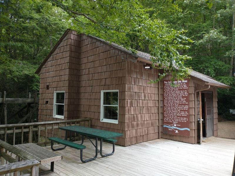
Visiting this area over 100 years ago, you would have found these mountains to be logged and pastured. During the later half of the 1800's a new industry found its way to East Tennessee and Western North Carolina.
An iron ore mine was operated . . . — — Map (db m177171) HM
The land you are standing on was farmed by the Miller family from the late 1800's to the 1960's. Three generations of Millers carved a home and a living out of this rocky mountain soil. Mountain farmers were compelled to be tough, strong, practical, . . . — — Map (db m286981) HM
Range School was in operation prior to Oct. 29, 1843. It began as a common school with classes held in a log sheep barn donated by Jonathan Range. In 1901, a one-room frame building was constructed near the original site. A brick building was . . . — — Map (db m53528) HM
Comedian, singer, painter, golfer, television host, scriptwriter, businessman and raconteur Archi Campbell is principally remembered for his roles on the long-running television series , "Hee Haw". One of his comedic trademarks was spoonerisms, . . . — — Map (db m179404) HM
Hamblen County
Established 1870; named in honor of
Hezekiah Hamblen
of Hawkins County.
Hawkins County
Established 1786; named in honor of
Benjamin Hawkins
member of Continental Congress from North Carolina; U.S. Senator . . . — — Map (db m210292) HM
One mile west is the site of the store established by John Carter and William Parker. This store was pillaged in the Shawnee raid of 1774. at the Sycamore Shoals Treaty in 1775, the proprietors were awarded the whole Carter's Valley as reparation. — — Map (db m91887) HM
On the site of this mill, Robert Patterson build a fort about 1775, shortly thereafter a mill. It was one of two stations at which the settlers took refuge during the Cherokee raid under The Raven in 1776. — — Map (db m91886) HM
On the site of this mill, Henry Rice built and fortified a mill in 1775. Here, in 1776, the settlers took refuge from warring Cherokee. In April, 1777, Capt. James Robertson and eight other pioneers had a fight with 30 or 40 Cherokee near here, in . . . — — Map (db m91888) HM
About 2 1/2 miles south, now under water, William Cocke had his plantation. A veteran of the Revolution and the War of 1812, he served in the legislatures of Virginia, North Carolina, Franklin, Transylvania, Territory South of the River Ohio, . . . — — Map (db m91862) HM
Three-tenths of a mile north at 132 Church Lane, Hugh G. Williams and Carrie Moore Williams, descendants of Hugh G. Moore, a founder of Mooresburg, resided here in the late 1800s. The Williams owned the Mooresburg Springs Hotel, a well-known mineral . . . — — Map (db m91863) HM
About 1½ miles west and north of here, in Carter’s Valley, Joseph Kinkead and John Long, first known pioneers to what later became Hawkins County, settled in 1769-70. The valley is named for Colonel John Carter, who first settled here and later . . . — — Map (db m104341) HM
Near here was the site of “New Market,” home of Joseph McMinn, Revolutionary veteran, governor of Tennessee, 1815–1821, and Indian agent for the Cherokee from 1822 to his death near Calhoun, on Hiwassee River, in 1824. He is buried . . . — — Map (db m104342) HM
Born here, Oct. 2, 1821: graduate USMA, 1842; resigned 1845, and a professor Cumberland U., and U. of Nashville until 1861. Appointed major, CSA, quickly advanced to brigadier general; Successively to corps command, Army of Tenn., and twice . . . — — Map (db m91881) HM
About 1 1/2 miles south is the stone house built by Thomas Amis between 1781 & 1783. He was Captain and Commissary of North Carolina troops in the Revolution; an original member of the Society of the Cincinnati, and legislator. He established here . . . — — Map (db m91872) HM
3½ miles southeast, on the south side of Big Creek, “The Father of Middle Tennessee,” then a captain, lived in 1777 and 1778. A fort here was garrisoned during the Indian troubles. From there in 1779, Col. Even Shelby embarked 300 men in canoes and . . . — — Map (db m210291) HM
John G. Bynum and his wife Nancy Bradley Phipps Bynum, owned this house during the Civil War. The value of his land and slaves in 1860 totaled $140,000, an enormous sum for the time. Bynum helped raise the county's first Confederate unit, the . . . — — Map (db m97662) HM
Dr. Franklin, a very well known and highly respected educator and humanitarian, founded Swift Memorial Junior College in 1883 and served as President of the school until 1926.
Dr. and Mrs. Franklin are buried in this plot on the campus of Swift . . . — — Map (db m91867) HM
Right To commemorate John Carter, sturdy pioneer, first merchant after whom this valley is named.
Left To commemorate Benjamin Hawkins of North Carolina, Senator of the United States, after whom this county is . . . — — Map (db m98426) HM
This county was both Spencer County, State of Franklin, and Hawkins County, State of North Carolina 1786 - 1788, and became Hawkins County, Tennessee in 1796. — — Map (db m91897) HM
7.9 miles north was the homestead of this pioneer, veteran of Lord Dunmore's War, and of the Revolution, originally from Botetourt County, Va. Among his descendants were Joseph Emerson Brown, governor of Georgia during the Civil War, and his son, . . . — — Map (db m91880) HM
The Church was organized in 1805 and in 1824 this cemetery was first used. In 1838 the Church split into the Old School or First Church and the New School or Second Church and this cemetery continued in use y the First Church. In 1881 the two . . . — — Map (db m91866) HM
Alexander Fain, Jordan Netherland, Albert Jones, and Nathaniel Mitchell, all Black Americans, purchased this land in 1868 "for the purpose of building a schoolhouse for the education of colored children." A two-room log building was constructed and . . . — — Map (db m91870) HM
Many of the early settlers of Hawkins County are buried in this cemetery, 170 yards south, including Joseph Rogers, the founder of Rogersville, and his descendants. The grandparents of David Crockett who were massacred by the Indians are also . . . — — Map (db m91864) HM
Joseph Rogers' tavern included the Old Tavern and Big Tavern Houses. Located 45 yards to the south, the Old Tavern House was built between 1790 and 1800. Built between 1800 and 1810, the Big Tavern House is located 25 yards south. Both Buildings . . . — — Map (db m91865) HM
In June 1861, 1,250 Hawkins County residents voted against secession, while 835 voted in favor. Rural residents tended to have Unionist sympathies but townspeople such as those in Rogersville sided with the Confederacy.
Confederate forces often . . . — — Map (db m114004) HM
The Hawkins County Chapter of the Association for the Preservation of Tennessee Antiquities, (A.P.T.A.), has chosen to fund and erect this monument to commemorate the nearby site of the original town well in Rogersville.
This marble block was . . . — — Map (db m91899) HM
Originated in 1875, St. Marks was the first black Presbyterian Church in Rogersville. Formerly located in the Tenth Civil District, now McKinney Avenue, the church moved to the corner of Kyle and Hasson Street in 1912. The Reverend William H. . . . — — Map (db m91868) HM
Dr. William H. Franklin, the founder and President of Swift College, was one of the first black graduates from Maryville College, receiving his degree in 1881. Swift College was named to honor Elijah E. Swift, president of the denomination's . . . — — Map (db m91869) HM
At the invitation of Territorial Gov. William Blount, George Roulestone and Robert Ferguson brought a printing press over the mountains from North Carolina, and established the Knoxville Gazette in a log cabin on the Hawkins County Courthouse . . . — — Map (db m91871) HM
Along Big Creek the 2nd Illinois Artillery spent an uncomfortable night as a cold rain fell in the early morning hours of November 6, 1863. Nearby, under orders to strike the Union camp that morning, two Confederate brigades were crossing the . . . — — Map (db m114918) HM
This hill-locked body of land was discovered in 1774 by Castleton Brooks, onetime Long Hunter, who settled here in 1775 and was killed by Indians in 1777. A fort was here in 1775, under the command of Captain Robert Kyle. — — Map (db m104337) HM
Born in Surry (now Sussex) Co., Virginia, in 1734, he settled here in 1778, having been forcibly ejected from a homestead about 12 miles east by one Robert Young. The courts of Spencer County, State of Franklin, met in his house 1785-87. On June . . . — — Map (db m91882) HM
Land, timber, and commercial opportunities drew settlers here to the banks of the Holston River. As the Civil War approached, the river's importance in the Tennessee Valley made it a contested transportation route. Hawkins County residents mostly . . . — — Map (db m97667) HM
Maxwell Academy was established by the Presbyterian Church in 1852 and named in honor of Captain George Maxwell, who fought in the Battle of Kings Mountain. Serving students in grades one through twelve, the academy was operation by the New . . . — — Map (db m91885) HM
About two miles southwest, about 1784, young Joab Mitchell, who had successfully made the trip to the North Fork of the Holston bringing salt for the besieged garrison at Big Creek Fort, was ambushed and mortally wounded by Indians. Beating them . . . — — Map (db m97664) HM
One-half mile west is this Presbyterian church, established in Carter's Valley in 1780 by Rev. Charles Cummings and Rev. Samuel Doak. It was moved to its present location in 1815. A cemetery is at the old site. — — Map (db m91884) HM
Judge and Mrs. Joseph A. Caldwell
relocated the 1840 Sullivan County
smokehouse to this site shortly after
1940 when they bought and restored
the Deery Inn for their residence. — — Map (db m158060) HM
Established in 1786, this was the first Methodist Episcopal Church to be erected on Tennessee soil. Bishop Francis Asbury preached here often. A ten-day revival held here by Rev. John A. Granade began the Great Revival of 1780-81. The chapel was . . . — — Map (db m82954) HM
The log section of Anderson Townhouse was built in 1792/95. It housed the first town commissioners of Blountville: Richard Gammon (1750-1833), Major George Maxwell (1751-1821) and Colonel John Anderson (1750-1817). All these men served the American . . . — — Map (db m69801) HM WM
This is where Union forces stood as they attacked Blountville on September 22, 1863, during a campaign to control the Virginia and Tennessee Railroad. On the day of the attack, the Confederates occupied Blountville while the Federal forces held the . . . — — Map (db m69699) HM
This is the Sullivan County Courthouse. Its interior was burned during the Union attack on Blountville on September 22, 1863, as Confederate and Federal forces vied for control of the Virginia and Tennessee Railroad, located a few miles east of . . . — — Map (db m69708) HM
You are in the former schoolyard of the Masonic Female Institute, where Confederate troops stood as they defended Blountville on September 22, 1863. Col. James E. Carter's 1st Tennessee Cavalry withdrew that morning of 1863 from the Watauga River to . . . — — Map (db m69806) HM
Here on September 22, 1863, Confederate forces commanded by Colonel James E. Carter fought a Union brigade led by John W. Foster. After delaying the Union advance for more than four hours, Carter withdrew toward Zollicoffer, now known as Bluff City. . . . — — Map (db m45822) HM
Dedicated to
the memory of the
Confederate soldiers
of
Sullivan County
Tennessee
War of 1861-65
Battle of Blountville
Sunday September 22,
1863 — — Map (db m158034) WM
William Deery built this kitchen about
1810 to serve his inn. Virginia Caldwell
described it as "tumble-down” in 1940
before the west and north walls were
reconstructed. It served as her weave
house. It is now furnished as an early
1800s . . . — — Map (db m158064) HM
This little building originally stood across the street and served as the office of attorney John Fain in the late 1800s. Some Blountville residents remember it as the office of attorney Homer Smith in the second quarter of the 20th century. It was . . . — — Map (db m210240) HM
Forged in Maryland by J. Regester & Sons, this bell was placed in a cupola atop the old section of the Sullivan County courthouse circa 1870, and hung there nigh 100 years.
This historic bell was mounted here on the courthouse lawn by the . . . — — Map (db m158019) HM
Tradition holds that Immanuel Lutheran Church, organized in 1793 by German immigrants, is the oldest Lutheran Church in Tennessee. Built with bricks made by Cain Pottery, the church contains an 1864 Belgium-produced bell. Before the erection of . . . — — Map (db m304894) HM
This military road from Chilhowee, Va. to present day Kingsport was completed September 1761 by Major Andrew Lewis under command of Col. Adam Stephen. Upon reaching the Long Island of the Holston, the militia erected Fort Robinson to treat for peace . . . — — Map (db m47541) HM
James Brigham, a pioneer and Revolutionary War
soldier, purchased 1,070 acres along Muddy Creek
in modern-day Sullivan County between 1782 and
1787. On December 11, 1792, he deeded 30 acres
to John Anderson, George Maxwell, and . . . — — Map (db m158022) HM
This 1790 log cabin was the office of the
James King Ironworks, which was located
at the junction of Beaver and Steele
Creeks near Bristol, TN. When the city
announced plans to construct its waste-
water treatment plant on the site in . . . — — Map (db m158063) HM
In September 1863, Confederate Gen. Samuel Jones’s command and Union Gen. Ambrose E. Burnside’s forces contested control of the Virginia and Tennessee Railroad a few miles east. On September 22, Union Col. John W. Foster’s brigade engaged the forces . . . — — Map (db m69712) HM
Built shortly after 1785 by William Deery. Stopping place for many distinguished travelers of early days, Andrew Jackson, James K. Polk, the Marquis de Lafayette, Prince Louis Phillipe, Andrew Johnson and others enjoyed its hospitality. It operated . . . — — Map (db m82955) HM
Ralph Blizard, a Hall of Fame long-bow fiddler, was a pioneer entertainer on radio stations WOPI, WJHL and WKPT, at first with his high school classmates. He recorded and toured with the New Southern Ramblers across the United States and the British . . . — — Map (db m45846) HM
William Deery built this brick building in the early 1800s to house his slaves. Very few original slave buildings still exist in northeast Tennessee. — — Map (db m210235) HM
Sullivan County was established by the North Carolina Assembly’s October 1779 session; its north of the Holston River section formerly in Washington County, Virginia; and its south of the river section formerly in Washington County, North Carolina. . . . — — Map (db m69711) HM
Dedicated to all veterans
of Sullivan County
to the honor and glory
of those who proudly served
to keep our country a land of freedom
— — Map (db m158036) WM
The Presbyterian Church established here in 1773 is probably the first church of any denomination to be established within the borders of Tennessee. It was also used as a fort, and school was held here on Sundays, in pioneer times. — — Map (db m45658) HM
You are standing in front of the Miller-Haynes house, known as the Cannonball House because of structural damage it sustained from Union cannon fire during the Battle of Blountville on September 22, 1863. During the artillery exchanges, Confederate . . . — — Map (db m69805) HM
In June of 1843 land was acquired from Laurence Snapp of Blountville and the first building of the church was erected across from the present Blountville Glass Company. The deed stated in Laurence Snapp's words that the land was given to James . . . — — Map (db m210247) HM
The historic log structure from the late 1700's was built in an area possibly known as Sapling Grove in Johnson County, Mountain City, TN. In the late 1950's it was moved to Elizabethton where it was a part of a tourist attraction which included a . . . — — Map (db m210252) HM
When first a settlement, this was called Choate's Ford. With establishment of the Abingdon, Va-Knoxville stage line, it became known as Middletown. Laid off as a town, following completion of the railroad, it became Union. Early in 1862, it was . . . — — Map (db m22907) HM
This pioneer from Maryland built the house which stands .1 mi. N., in 1773, bringing his bride here in 1775. Following his return from the Revolution, he opened his house to Methodist missionary preachers. Bishop Francis Asbury was a frequent . . . — — Map (db m80631) HM
2.1 Mi. E. on Island Park Road and on hill to left above the spring stood the residence fort of Captain Jacob Womack, who served in colonial & Revolutionary wars. Built before 1774 it served to protect nearby settlers from Indian attacks. About 1785 . . . — — Map (db m22908) HM
This owner-driver's popular Winston Cup title in 1992 prompted many drivers to field their own teams. The mechanical engineering graduate recorded two of his five career triumphs at Bristol. He died in a plane crash April 1, 1993, en route to . . . — — Map (db m224130) HM
Tennessee AMVETS dedicates
this memorial to all veterans
living or deceased who have
honorably served their country
that freedom may reign
December 15, 2001
Governor
Don Sundquist
— — Map (db m143588) WM
524 State Street
Built 1893
Tenants
Merchants Exchange Bank 1893
Exchange Bank & Trust 1900
The National Bank of Bristol 1902
Citizens Bank Of Bristol 1906
Bank Of Bristol 1911
The City Bank 1922
Ralph Peer Bristol . . . — — Map (db m258206) HM
On May 13, 1952, at Bristol, Virginia's Shaw Stadium, located less than one mile from here, nineteen year-old Ronald Andrew Necciai, pitching for the Class D Appalachian League Bristol Twins, struck out 27 Welsh Miners in a nine inning no-hit, . . . — — Map (db m258198) HM
The town of Bristol was planned and laid out by Joseph Rhea Anderson in 1852. Development began on this site in 1853 with the erection of Anderson's combined home and business. The building served as the community's first store, post office, bank, . . . — — Map (db m258194) HM
Bristol has long been known as a hub for traditional mountain music. In the summer of 1927, Ralph Peer, a record producer from Victor Talking Machine Company, traveled to Bristol and set up a portable recording studio four blocks east of this . . . — — Map (db m258047) HM
Landmark Bridge
Between Two States
Erected 1910
Placed on the
National Register of Historic Places
By the United States Department of the Interior
September 8,1988
Marker in memory of Mattie and Jim Owens
The National . . . — — Map (db m258193) HM
In 1927 Ralph Peer, a record producer with the Victor Talking Machine Company, set up a temporary music studio on this site. Over the next 12 days he recorded 76 songs by 19 artists, including the Stonemans, and the first recordings of Jimmie . . . — — Map (db m82956) HM
Victor
First Country Music Recordings
July • August 1927
State Street, Bristol
Ralph Peer/Victor • Carter Family
Stonemans • Jimmie Rodgers
1927 — — Map (db m304890) HM
Nine Bristol victories, nine Bristol pole positions. The only driver to lead every lap of a 500-lap Bristol event (1973). During unprecedented three Winston Cup title seasons (1976-78), he won five out of the six Bristol races. He retired with 83 . . . — — Map (db m224055) HM
Catherine "Cathy" DeCaterina, Bristol native, Fairmont Elementary, Tennessee High School, and Sullins College graduate, went on to study voice at the Julliard School in New York City. While singing in New York, she met and married Frank DeCaterina . . . — — Map (db m211074) HM
The Great Valley of Tennessee, the Southern Appalachian breadbasket, stretches from Bristol to Chattanooga and with its major turnpikes and railroads was strategically vital to both North and South during the war.
The “better half of the . . . — — Map (db m143534) HM
On this site was formerly located the Bristol general Confederate Hospital. It was housed in the former Exchange Hotel erected in 1858 (later known as the Nickels House). The building was demolished in about 1898. Sick and wounded soldiers were . . . — — Map (db m157955) HM
At this speedway on April 1, 1979, "The Intimidator" recorded the first of his 76 career NASCAR Winston Cup Series victories. The seven-time series champion won nine cup events and one Busch Series race here at Bristol. From 1985 to 1988, he won . . . — — Map (db m224052) HM
Bristol's all-time leading winner recorded 12 of his 84 career victories here. He won three Winston Cup championships (1981, 82, 85). Among the Tennessee resident's greatest achievements is his seven-race winning streak in Winston Cup events at . . . — — Map (db m224113) HM
The "Silver Fox" won 105 races at NASCAR's top level, including five at Bristol during a five year span (1967-71). This three-time champion won back-to-back titles in 1968 and
1969, a period when he won Three out of four Bristol events. He is one . . . — — Map (db m224057) HM
During the Civil War, Bristol was a strategic location on the East Tennessee and Virginia Railroad. The Confederate Medical Corps established hospitals in the town, which soon became an important medical center. Wounded soldiers were brought by . . . — — Map (db m82957) HM
The first burial in East Hill Cemetery was a five - year old girl in 1857. Since that time there have been approximately 4000 burials including the founder of Bristol. There are approximately 300 Civil War soldiers, veterans from other wars, and . . . — — Map (db m305054) HM
Born in Wales, 1719, he came here about 1771. A veteran of Braddock's Campaign and Lord Dunmore's War, he commanded a successful expedition against the Chickamauga towns, 1779. Member of the North Carolina State Senate, 1781, and brigadier general . . . — — Map (db m22995) HM
This fort was erected on high ground about two blocks south, in 1771, for the protection of the pioneer settlers. From it went forces to the battles of Point Pleasant, Long Island Flats and Chickamauga Towns. Here also occurred the preliminary . . . — — Map (db m82958) HM
(North Face)
Erected August 16, 1971
Honoring
A.P. Carter
Sara Carter
Maybelle Carter
Jimmie Rodgers
Who recorded the first Country and Western music to be distributed nationwide in Bristol, Tennessee on August 2, 1927
(West . . . — — Map (db m24036) HM
1/2 mile north, in 1784, Col. James King, Revolutionary veteran who was at Yorktown, built an ironworks at the mouth of Steel's Creek. A later associate was Governor William Blount. With the King Ironworks was also the first nail factory in the . . . — — Map (db m22911) HM
Erected in 2010 in honor of Joseph Rhea Anderson (1819-1888) who founded the original Town of Bristol, Virginia/Tennessee in 1852. Both sides of the town were given recognition on the official records of the time. He erected the first building in . . . — — Map (db m82959) HM
Colonel Isaac Shelby was a leader of frontier American forces resisting British rule. British officer Patrick Ferguson was aware of Shelby's presence in the area and sent out a warning, if the rebels did not desist in their opposition to British . . . — — Map (db m135593) HM
The winner of four NASCAR cup series championships, Jeff Gordon helped transform auto racing into a mainstream American sport. Gordon recorded 93 cup series wins in his career. His Bristol highlights include five cup victories, including four . . . — — Map (db m224125) HM
Jimmie Rodgers, known as “The Singing Brakeman” and “the Blue Yodeler,” was born in Meridian, Mississippi on September 8, 1897. After working as a brakeman for the railroad, a bout of tuberculosis forced Rodgers from the . . . — — Map (db m23145) HM
Born in a house 300 yards east of this road, Oct. 23, 1857, he held nearly every public office in his county, besides being three times member of the General Assembly. While
Speaker of the State Senate, he became Governor to succeed James B. . . . — — Map (db m157959) HM
It crosses the highway here. Originally a branch of the Great War and Trading Path, it was later an important route from Virginia to the west. The first mail route between Richmond and Washington ran over it. Many notables used it, including Andrew . . . — — Map (db m157952) HM
Legendary Junior Johnson claimed his first Bristol victory as both car owner and driver in the 1965 Southeastern 500. Drivers Charlie Glotzbach, Bobby Allison, Cale Yarborough and Darrell Waltrip drove his cars cars to more Bristol victories, giving . . . — — Map (db m224128) HM
Located 4 miles to the east in Bristol, Tennessee. Founded in 1867 by the Reverend James King and other Presbyterian leaders to provide "a thorough classical and scientific training, combined with moral and religious instruction." Since 1915 this . . . — — Map (db m22913) HM
599 entries matched your criteria. Entries 101 through 200 are listed above. ⊲ Previous 100 — Next 100 ⊳