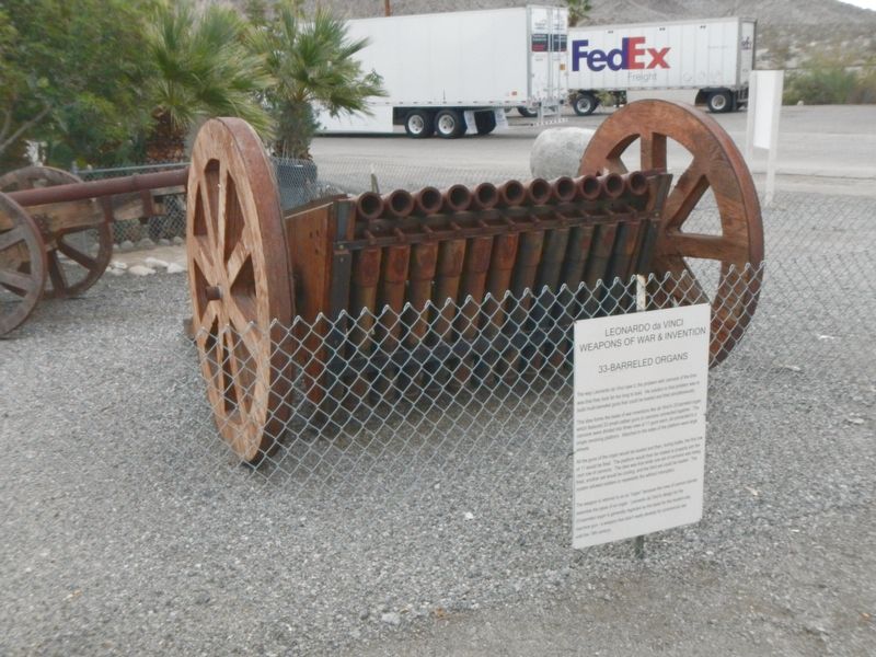
The way Leonardo da Vinci saw it, the problem with cannons of the time was that they took far to long to load. His solution to that problem was to build multi-barreled guns that could be loaded and fired simultaneously.
This idea forms the . . . — — Map (db m99299) HM
Training troops in desert warfare in preparation for Operation "Torch." The invasion of German held North Africa. The world's largest military installation, training 60 divisions and more than one million soldiers. — — Map (db m99284) HM
The Camp Young Airstrip was established at this site in March 1942 by order of General George S. Patton. It was used to provide Camp Young with supplies and other essential material. It supported air transportation for the command staff of the . . . — — Map (db m78550) HM
It was in 1346 that the English first used cannons which, propelled by exploding gunpowder, fired stone balls. Despite this, progress in that area of military weaponry was not fast, and it was here Leonardo's particularly applied his thinking. This . . . — — Map (db m99298) HM
The basic design of the catapult had been in use for hundreds of years before da Vinci embarked on improving it. He actually came up with different models. This particular design used a double leaf spring to produce an enormous amount of energy in . . . — — Map (db m99294) HM
“For conspicuous gallantry and intrepidity at the risk of life above and beyond the call of duty..”
Colonel Mitchell Paige, U.S. Marine Corps, October 26, 1942 • Hospital Corpsman First Class Robert E. Bush, U.S. Navy, May 2, 1945 • . . . — — Map (db m108612) WM
The D.T.C was established by Major General George S. Patton Jr. in response to a need to train American combat troops for battle in North Africa during World War II. The camp, which began operation in 1942 covered 18,000 square miles. It was the . . . — — Map (db m50700) HM
There are several designs for horse-drawn scythed chariots among Leonardo's sketches.
The first involved the use of four large scythes which were mounted in a manner similar to helicopter blades. Leonardo was a peaceable man who despised war, . . . — — Map (db m99297) HM
In 1933, Dr. Sidney R. Garfield opened Contractors General Hospital thirteen miles east of here. This facility successfully delivered health care to Colorado River Aqueduct workers through an innovative prepaid insurance plan. Later, in association . . . — — Map (db m153949) HM
Joseph L. Chiriaco came to California from Alabama in 1925. His work as a surveyor for the Los Angeles Bureau of Water and Power and later for the Metropolitan Water District on the Colorado River aqueduct, begun in 1931, brought him to the desert . . . — — Map (db m78543) HM
[This is a four sided monument displaying three different markers:]
Desert Training Center
Camp Young
Maj. Gen. George S. Patton Jr., U.S. Army, selected Camp Young as headquarters site for the Desert Training Center in . . . — — Map (db m32139) HM
During the opening days of the World War II, more than 18,000 square miles of the Arizona and California desert were designated by the U.S. Army as a military training facility. The facility, conceived by General George Patton and referred to as the . . . — — Map (db m78512) HM
Camp Coxcomb was established at this site in the Spring of 1942. It was one of fifteen such camps built in the southwestern deserts to harden and train United States troops for service on the battlefields of World War II. The Desert Training Center . . . — — Map (db m78513) HM
Camp Young, named after Lt. Gen. S.B.M. Young, the 1st Army Chief of Staff, was established at this site in the Spring of 1942. It was one of twelve such camps built in the southwestern deserts to harden and train United States Troops for service to . . . — — Map (db m78581) HM
Wall of Honor
These Stars are Dedicated to the Veterans of Riverside County who were awarded the Medal of Honor by the President of the United States.
These Recipients performed with Valor and Heroism “Above and Beyond” the . . . — — Map (db m114707) WM
This water trough was constructed on the Southern Pacific Railroad property along Cantaloup Avenue for watering teams of horses hauling cantaloupes and onions. It replaced a wooden trough on Front Street used in the early industry of shipping . . . — — Map (db m113032) HM
It seems to me that the strangest and wonder of existence are emphasized here, in the desert, by the comparative sparcity of the flora and fauna: life not crowded upon life…with a generous gift of space for each herb and bush and tree, each stem . . . — — Map (db m92513) HM
Mortar holes and rock paintings mark this as a one time Indian habitation. Gold and silver prospectors found the spring flowing as late as the 1920s. One of them, Gus Lederer, gave up roving and became known as "Mayor of Corn Springs." He lived in a . . . — — Map (db m63887) HM
The Iron Chief, Black Eagle and other mines produced gold at Eagle Mountain between 1881 and 1900 from ores containing as much as 54 per cent iron. L.S. Barnes secured options and sold the mines to Southern Pacific Railroad in 1909. Kaiser Steel . . . — — Map (db m124247) HM
The Palen Pass Maneuver Area was the largest training zone within the Desert Training Center/California-Arizona Maneuver Area. Various exercises occurred, including the mock battles of Palen Pass and Southern California, which involved two Divisions . . . — — Map (db m172166) HM WM
A common question asked by visitors entering Joshua Tree National Park through the southern entrance is “Where are the Joshua trees?” Sometime the Mojave yucca, a close relative is mistaken, for a Joshua tree. The reality is that Joshua . . . — — Map (db m92514) HM
Kavanish Village For some 400-500 years, the Indian Wells area was home to a series of Indian villages. Best known was the Cahuilla village of Kavanish. It was located north of the Whitewater River and northwest of where the Miles Avenue . . . — — Map (db m233013) HM
Dwight David Eisenhower, born on October 14, 1890, the third of six sons to a modest family in Denison, Texas, was raised in Abilene, Kansas. He excelled in baseball and football in high school. Eisenhower saw education as a way to better himself . . . — — Map (db m82137) HM WM
Eisenhower Mountain towers 1,952 feet above Eldorado Country Club, the oldest residential country club in Indian Wells, and the desert home of President and Mrs. Dwight D. Eisenhower.
"Ike" and Mamie spent many winters beneath the peak, . . . — — Map (db m113069) HM
The Eisenhower Walk of Honor allows all of us to recall the debt of gratitude owed to ordinary people for extraordinary acts of patriotism and courage. Men and women doing their duty for their country, honorably and with integrity.
This tribute . . . — — Map (db m114773) HM WM
Honoring the memory of the early Cahuillan Indian Clans who dug the Indian well 400 feet back of this monument, and the pioneer settlers, prospectors and stage line passengers who camped at the county well, located 50 feet back of this monument. The . . . — — Map (db m82466) HM
This K-8 one room schoolhouse, once known as the Indio Public School, was the second school building to be erected in the area that is now Indio. Originally situated on the Southeast corner of Bliss and Fargo, it was later moved behind the original . . . — — Map (db m78528) HM
Dr. June Robertson McCarroll was born June 30, 1867 in the Adirondacks and began her medical career in Chicago. She left a promising practice for Indio in 1904. Becoming the sole practicing physician for the entire Coachella Valley. She traveled by . . . — — Map (db m78540) HM
The Coachella Valley's developing agricultural industry created a need for electric services. Substation were located next to cold storage houses, providing power to preserve the Valley's bountiful produce. In 1943, the Imperial Irrigation District . . . — — Map (db m113068) HM
In 1926 Smiley Place was built by Dr. Harry W. Smiley. It served as the first medical office in Indio, as well as a residence for he and his wife, Frances. The Smiley's made significant contributions to the social and medical development of the . . . — — Map (db m50728) HM
USS Liberty Tree
May 1, 2004 this grand ole Cork Oak tree dedicated to honor all members of the Armed Forces. As a 50th commemoration of the Korean War 1950-1953, we honor the 5,720,000 Americans who served, the 33,651 killed in action, the . . . — — Map (db m142705) WM
This building was constructed by the Palm Springs Land and Irrigation Company as administrative offices in 1935. The company developed lots in the La Quinta Cove, known then as Vale La Quinta.
In the 1970s, the Frances Hack Real Estate Company . . . — — Map (db m233359) HM
The Bradshaw Trail
Circa 1862
To the Cahuilla, the native people of this valley, this point of land was important because it marked access to water. They dug a well into the wash with steps leading down to water level less . . . — — Map (db m232942) HM
Once connected to the Gulf of California, waters within the Salton Basin extended nearly to Palm Springs. Because of deposits from the silt laden Colorado River, the north end of the gulf (now in Imperial County) was sealed off and Lake Cahuilla was . . . — — Map (db m78567) HM
This property has been listed in the National Register of Historic Places by the United States Department of the Interior.
Designed by architect Albert Frey, the building resembles a ship with its curved prow, second-story ‘bridge’, . . . — — Map (db m131763) HM
In Memoriam
In Deep Appreciation of
These Courageous Young Americans
From the Coachella Valley
Who Have Made the Supreme Sacrifice.
Killed In Action
Vietnam
P.F.C. Dennis Read — Army
Spl./4th Class, Edwarxd Angiano . . . — — Map (db m113335) WM
These stars are dedicated to five citizens of this community who were presented with the Medal of Honor by the President of the United States.
Together, their fields of battle included World War II, Korea, Vietnam and service on the high . . . — — Map (db m206206) WM
Angel Cove is named for an angel-shaped rock formation located at the top of
the cove's largest canyon. The formation, depicted to the right, is best viewed
from a distance across the valley. The naming of Angel Cove is also attributed to
a . . . — — Map (db m232915) HM
WW II searchlights formed part of a system of aircraft detection linking (a) locator device, (b) searchlights, and (c) antiaircraft (AAA) guns. The locators Sent electronic information to the lights and guns, which in turn tracked the target in . . . — — Map (db m206326) HM
Bel Vista House
Architect Albert Frey
has been placed on the National Register
of Historic Places by the United States
Department of the Interior
1946 — — Map (db m192259) HM
Hollywood screen and television star, Charlie Farrell, was Mayor of the City of Palm Springs from 1948-1958. While Mayor, he helped secure the return of the Airport to the City after World War II. He founded the Racquet Club with actor Ralph Bellamy . . . — — Map (db m206193) HM
On this site in 1908, Nellie N. Coffman (1867-1950),
husband Harry and two sons, George Roberson and Earl Coffman established a small health resort hotel, Desert Inn. Her ability, determination, and charm extended the resorts reputation and people . . . — — Map (db m113078) HM
The Distinguished Flying Cross
Authorized by Act of Congress 2 July, 1926
"Wall of Honor"
Dedicated on November 11, 2004
Awarded to any person who, while serving in any capacity in the Armed Forces of the United States, . . . — — Map (db m206322) WM
This small Spanish Eclectic structure was the northernmost residence in the village of Palm Springs when it was built in the 1920s. As the city grew, there was an increasing need for community services, especially along "Main Street," and Dr. Smith . . . — — Map (db m82141) HM
Prescott T. Stevens, developer of the El Mirador Hotel, donated this site and the funds to build the Frances S. Stevens School, in memory of his wife and her interest in education. The first two rooms were completed in 1927. Katherine Finchy, who . . . — — Map (db m82139) HM
The F-16 is numerically the most important fighter int the Western worlds inventory. Developed for the US Air Force, it embodied lessons learned over Vietnam and was designed as an inexpensive and small version of the F-15.
Since it possessed . . . — — Map (db m206404) HM
This structure was built c. 1934 by the California Water & Telephone Company as a business office and switching center. It was purchased by General Telephone in 1967 and continued as a switching center until 1984. The structure is constructed of . . . — — Map (db m52738) HM
The United States Navy needed an all-weather carrier-based attack aircraft. The Douglas A-1 Skyraider did its job in the Korean War, but they desired a new aircraft with twin jet engines. The Grumman A 6 Intruder was introduced in 1963 and served as . . . — — Map (db m206437) HM
This property has been listed in the National Register of Historic Places by the United States Department of the Interior.
This Mediterranean/Spanish Revival home was built by John and Fannie Hamrick and designed by John Porter Clark and . . . — — Map (db m206177) HM
Dedicated to all American who offered their lives in support of freedom throughout the world.
Dedicated February 24, 2003 by Jewish War Veterans of the U.S.A., LCDR Ben Dobris Post 750, Palm Springs.
Donated By Wiefels & Son Funeral . . . — — Map (db m206278) WM
This property has been listed in the National Register of Historic Places by the United States Department of the Interior.
Loewy House, 1946.
Designed by architect Albert Frey for famed industrial designer Raymond Loewy. The house . . . — — Map (db m206182) HM
Desert pioneer, Carl Lykken, built the first general store in the village in 1914. For many years it contained the only telephone and the post office. The store was remodeled with the existing overhang and arches when sidewalks were installed in the . . . — — Map (db m52734) HM
Joining more than 200,000 locations around the world, this Palm Springs Pole brings the international initiative to this international city. Founded in 1955, the global Peace Pole Project seeks to "uplift humankind toward harmony rather than . . . — — Map (db m206210)
The McCallum Adobe, the oldest remaining building in Palm Springs was built in 1885 for John and Emily McCallum, the areas first white settlers. Originally constructed on the corner of Palm Canyon Drive and Tahquitz Way, and later a part of the . . . — — Map (db m52731) HM
The A-4 Skyhawk is a lightweight, single engine attack aircraft The first A-4 was delivered to the Navy in 1956 and the Marine Corp in November 1962; 765 A-4 aircraft have been sold worldwide. The A-4 is one of the most effective and versatile light . . . — — Map (db m206319) HM
The McDonnell Douglas F/A-18 Homet is a twin-engine, supersonic, all-weather,carrier-capable, multirole combat jet
designed as both a fighter and attack aircraft (hence the FA designation), Designed by McDonnell Douglas (row Boeing)
and Northrop, . . . — — Map (db m206443) HM
This public park was deeded to the City of Palm Springs in 1970 by the Mccallum Desert Foundation in memory of Pearl M McMannus, further implementing her life-long plan to improve and beautify Palm Springs. The building to the left was the adobe . . . — — Map (db m206212) HM
The Mig-15 was one of the first successful jet fighters to incorporate swept wings to achieve high transonic speeds. In combat over Korea, it outclassed straight-winged jet day fighters, which were largely relegated to ground attack roles. The . . . — — Map (db m206398) HM
Made famous by the Vietnam War, the MiG-17 was the primary enemy aircraft engaged in the skies over Vietnam by U.S. aircraft, such as the A-4, A-7, F-8, B-52, F-100, F-105 and its primary nemesis, the F-4 Phantom II. During that war and up until the . . . — — Map (db m206321) HM
The Oasis Hotel, constructed 1923-25, contained approximately 20 units and included the Tower Building, the only three story hotel building in Palms Springs for many years.
The 40 foot tower, with its pyramidal roof, provided access to the . . . — — Map (db m52742) HM
One of the two original tram cars that made the inaugural trip up Chino Canyon on September 12, 1963, it made over 175,000 round trips by the time it was retired in June 2000.
The Palm Springs Aerial Tramway was the longest and steepest . . . — — Map (db m210754) HM
The American Legion is the nation's largest wartime veterans service organization.
Post #519 was first chartered in May, 1939.
This austere war memorial building features a unique "lamella” roof created by interlocking pre-cut wood pieces . . . — — Map (db m206259) HM
This is one of the original street markers used following the incorporation of the City of Palm Springs in 1938. Dr. J. J. Kocher and Philip Boyd, then secretary of the Chamber of Commerce, had renamed the streets in 1930 at which time Main Avenue . . . — — Map (db m82140) HM
This bridge-like structure straddles a gully, allowing water, and the occasional boulder, to pass underneath without damaging the building. The walls of glass offer a view of the mountain. The interior ceiling is of perforated and corrugated . . . — — Map (db m210755) HM
In honor of those who have served in the armed services of the United States from the American Revolution to present and to those who gave their lives in service to protect our freedoms in all military conflicts.
We also pay special tribute . . . — — Map (db m206394) WM
Designed by Albert Frey, John Porter Clark, Robson Chambers, and E. Stewart Williams
This building is made of concrete block. Tubular aluminum bris-soliel offers shade, while allowing a view. In front of the City Council chamber is a large . . . — — Map (db m206254) HM
Founded in 1938, the Palm Springs Desert Museum is an educational institution that promotes a greater understanding of art, natural science and performing arts. This building designed by E. Stewart Williams, first opened in 1976 — — Map (db m206200) HM
The Palm Springs Desert Museum, founded in 1938, has occupied three distinct locations in downtown Palm Springs. This building, designed by local architect, E. Stewart Williams, AIA, was first opened in 1976. Williams then design an expansion that . . . — — Map (db m240219) HM
The Plaza Theatre opened in December 1936 with a screening of "Camille", a tragic love story starring Robert Taylor and Greta Garbo; actor Ralph Bellamy served as master of ceremonies for this event which attracted about 40 Hollywood celebrities. . . . — — Map (db m82142) HM
Sandcliff Historic District
Completed in 1964
Mid-Century Modern
Designer: Sherwin L. Barton (1918 - 1995)
Between 1950 and 1956, the population of Palm Springs increased 60%. Developers responded producing numerous "garden apartment" . . . — — Map (db m284121) HM
Called Twin Palms for its landmark trees, the singer's modern, view orientated home uses strong horizontal and vertical forms, natural materials and decorative trellis.
Historic Site No. 77 - Class One — — Map (db m206185) HM
This is the site of the first community church in Palm Springs. Welwood Murray donated the land in 1906 and the little church stood as a landmark in the village until 1934. The existing Carnell Building designed by Harold Williams was completed in . . . — — Map (db m52736) HM
In the Spring of 1905, the Colorado River, swollen by heavy rainfall and snow-melt, surged into an irrigation canal east of where you are standing. The great "red bull" as settler called the river, overflowed the canals banks and spilled into the . . . — — Map (db m210761) HM
A rare example of a Depression Era Art Modern style building in Palm Springs. The double and triple bands of horizontal 'streamline' moldings, flat unembellished blocky wall surfaces, and symmetrical façade are characteristics of the Art Modern . . . — — Map (db m52737) HM
On this site in 1909, Dr. Harry and Nellie N. Coffman opened the Desert Inn in a single-family house as a small sanitarium for patients suffering from tuberculosis and other respiratory ailments. It established Palm Springs as a desert health resort . . . — — Map (db m206204) HM
The Grace Lewis Miller Residence
Completed 1936
Architect: Richard Neutra
International Style Modern
A masterful interweaving of Neutra's interest in climate,
landscape and health with Miller's progressive attitudes regarding
the . . . — — Map (db m309759) HM
McNaughton, a famed set designer and art director for television and motion pictures, designed this home in the Hollywood Regency style. — — Map (db m206181) HM
The Kausik Cahuilla are the owners of one of California's most famous hot springs. This natural resource provided them with permanent, palatable mineral waters which
were used for curing, drinking, and agriculture. It also was a direct access to . . . — — Map (db m142125) HM
At 10,834 feet, San Jacinto Peak is the second highest peak in southern California. Its north face rises over the desert floor, creating one of the steepest escarpments in the United States. The peak also helps create a landscape of extremes. Mount . . . — — Map (db m210759) HM
In 1926, philanthropist Thomas O'Donnell (1870-1945) began construction of a private golf course, which he opened to the public in 1932. In 1936 the O'Donnell's commissioned architectural designer William Charles Tanner to design a new home which, . . . — — Map (db m206197) HM
The warm spring here was the site of Se-Khe (Boiling Water), important village of the Kawasic Cahuilla Indians. The Spanish called it Agua Caliente (Hot Water). A stage station of that name operated from 1862 to 1876. As early as 1871 the Indians . . . — — Map (db m142126) HM
Dougherty (1877-1947), was recognized for his bold American Impressionistic paintings of coastal landscapes.
Clark's designs often blended materials commonly found in Spanish revival buildings with elements typical of Modern Architectural . . . — — Map (db m206180) HM
Completed 1955
Mid-Century Modern
Wexler & Harrison, Architects
Robert Higgins, Builder / Developer
The Sunmor neighborhood is generally known as an "Alexander" neighborhood, however Bob Higgins developed the first eleven . . . — — Map (db m206195) HM
Earthquake Faults Crisscross this land and shape its restless landscape.
The San Andreas fault cuts along the eastern side of the Coachella Valley. From where you are standing it runs parallel to Interstate 10 toward the base of . . . — — Map (db m212019) HM
Over a century ago, conservationist Aldo Leopold and forester Robert Marshall prompted the Forest Service to consider wilderness preservation as a worthy goal. They argued that wilderness itself was as important a resource as timber, water, or . . . — — Map (db m210760) HM
The Tie Down or "hardstand' was utilized during World War II when the Palm Springs Army Air Field was used by the Ferrying Division of the Air Transport Command. The principal reason for establishing the base in Palm Springs was to provide a . . . — — Map (db m206194) HM
This is a recreation of the sign guiding visitors to the Tonopah Test Range that was (is) the operational base for the F-117 Nighthawk.
The Tonopah Test Range (TTR, also designated as Area 52) is a restricted military installation . . . — — Map (db m206402) HM
Designed by Albert Frey and Robson Chambers.
Conceived by developer Culver Nichols as
an entry statement to Palm Springs, the roof
is a hyperbolic paraboloid of steel I-beams
and corrugated metal roofing supported by
steel tubular pillars. . . . — — Map (db m131565) HM
These statues represent African-American pilots from the 332” fighter group that provided protection for allied bombers during missions over Nazi-controlled territory. At the beginning of WWI some were opposed to the idea of African-Americans . . . — — Map (db m206324) WM
In 1938 George Welwood Murray donated this land to provide for a library as a memorial to his father, Welwood Murray, pioneer hotel operator. Cornelia white donated an additional strip of property on the eastern end of the site. The existing . . . — — Map (db m52732) HM
After nearly a century of timber production, parts of the San Jacinto Mountains looked like nothing more than a logging camp. Where tall trees once stood, stumps and wood debris littered the landscape. Livestock grazing also took its toll. John Muir . . . — — Map (db m210763) HM
Constructed of stucco, concrete, and steel with parts of the foundation resting on boulders, the home features a mountain waterfall and has finishes including mahogany doors, wood floors, wrought iron, and handmade tiles. — — Map (db m218629) HM
Albert Frey Bel Vista Home. #3
Completed 1946
International Style Modern
Albert Frey, Architect
Culver Nichols and Sallie Stevens Nichols, Developers
Bel Vista is the first modern housing tract built in Palm Springs.
Originally, . . . — — Map (db m290061) HM
143 entries matched your criteria. The first 100 are listed above. The final 43 ⊳