In the early dawn of January 9, 1861, the first shot of the War Between the States was fired from Morris Island by Citadel cadets under the command of Major Peter Fayssoux Stevens. The cadets opened fire with 24 pound siege guns on a Federal ship, . . . — — Map (db m67853) HM
In memory of Major Sam M. Savas, Jr., CE, USA Citadel 1951 Died in Vietnam, 1965 In memory of Lt. Sam M. Savas, III, USN Naval Aviator Citadel 1979 Died in the service of his country October, 1985 — — Map (db m67855) HM
This 10-inch mortar, unearthed during the excavations in 1959, is similar to the one which fired the signal shot from Fort Johnson on April 12, 1861. Later in the war, the Confederate defenders of Fort Sumter mounted several of these weapons near . . . — — Map (db m30647) HM
Designed by Thomas J. Rodman, U.S. Army Ordnance Officer, this type of cannon was the largest gun used in combat during the Civil War. These two Rodmans were brought to Fort Sumter as part of the 1870's modernization program. Tube Weight: 50,000 . . . — — Map (db m30641) HM
Discovered during the excavations of Fort Sumter, these rifled guns were installed by Federal troops during the 1870's modernization program. Maximum Range: 6800 yards (6218 M) — — Map (db m30679) HM
Property was sold by Thomas Pockney in 1795. Structure built in 1796 by Joseph Olman. Purchased by John H. Dosher 1880s. Sold to famous cabinet maker Edwin S. Smith in the 1960s and functioned as Smitty’s cabinet shop Awarded the Preservation . . . — — Map (db m242807) HM
Robert Parker Parrott designed the 6.4-inch, 8-inch and 10-inch Parrotts to serve on land or sea. These versatile rifled cannon were simple and inexpensive to construct. This gun, like many of the other weapons in Fort Sumter, was brought to the . . . — — Map (db m30764) HM
When the Confederates opened fire in April 1861, several 8-inch Columbiads were mounted in Fort Sumter. This weapon probably has remained here since then, weathering the Union bombardment of 1863 and the clean up of the 1870's. Archeological . . . — — Map (db m30646) HM
Built to defend the port city during the French and Indian War, Charleston's Horn Work was designed in 1757 by Lieutenant Emanuel Hess, a Swiss engineer serving with a British regiment. Hess used a durable oyster-shell cement called tabby to . . . — — Map (db m242354) HM WM
The row of cannon in front of you dates from the Civil War, when radical advances in technology increased power, range, and accuracy. Some large, old smoothbore cannon were "rifled and banded" to enhance firepower. Banding (heating and tightening . . . — — Map (db m30639) HM
In February 1780, the British army, 12,500 men strong under the command of Sir Henry Clinton, returned to capture the port city. Under the direction of French engineers, Charleston laborers, including many enslaved people, hurriedly erected . . . — — Map (db m242336) HM WM
Battery Huger (ũ-jẽ) looms before you. Battery Huger, the black, concrete structure filling the center of Fort Sumter, was built in 1899 in response to the Spanish-American War. Named for Revolutionary War hero Isaac Huger, the battery . . . — — Map (db m30552) HM
The Union Navy blockaded Charleston Harbor from 1861-65, but blockade runners continued to slip in and out, carrying cargo crucial to the economic and military survival of the South. Using neutral ports like Bermuda and Nassau, blockade runners . . . — — Map (db m30691) HM
The City of Charleston named this public square for Revolutionary War hero Brigadier General Francis Marion in 1882. The six-acre property was sold by the city to the Board of Field Officers of the Fourth Brigade of the South Carolina Militia . . . — — Map (db m242803) HM
A Private Residence
This outstanding Georgian House, designated of National Importance was built by William Branford (1715-1767), planter and member of the Colonial Assembly, on land inherited by his wife Elizabeth Savage (1731-1817). It is . . . — — Map (db m258560) HM
During the first half of the nineteenth century, many buildings on Broad Street between Church and East Bay Streets served as auction houses and private venues for the sale of human property. The firm of William Payne & Sons was likely the busiest . . . — — Map (db m242571) HM
Load … Ready … Fire! A disciplined crew of five men could fire an accurate shot in less than one minute. Teamwork and timing during battle were essential to the crew of this 42-pounder smoothbore cannon, one of 27 guns that occupied these . . . — — Map (db m30922) HM
In 1861 the port of Charleston prospered. Keeping the city open to trade was crucial for Confederate survival. Confederate forts in Charleston Harbor - including Fort Sumter - protected Charleston throughout the war despite Union blockade, . . . — — Map (db m30769) HM
In the late 18th century, an imposing fortification straddled the "Broad Path" (now King Street) just north of Boundary Street (now Calhoun Street). This "Horn Work,” the generic term for a fortress with a central entrance to control the traffic in . . . — — Map (db m242355) HM WM
Cigar Factory This five-story commercial building, built in 1882 as a textile mill, was known as the Charleston Manufacturing Company, then Charleston Cotton Mills, in its early years. Leased to the American Tobacco Company in 1903, the plant . . . — — Map (db m67363) HM
This 1961 marker commemorating the first shots of the Civil War does not mention the causes of the conflict. In its 1860 "Declaration of Immediate Causes," South Carolina, the first state to secede, called for secession to protect the institution . . . — — Map (db m284869) HM
Confederate control of Fort Sumter, Fort Moultrie, and supporting fortifications kept Charleston Harbor open despite the blockade by Union ships. The main ship channel passed directly in front of you, between Fort Sumter and Fort Moultrie, within . . . — — Map (db m30702) HM
Dates of Historical Interest
1822 First constructed as a two-storied armory and fortress as a result of the Denmark Vesey slave uprising.
1842 Occupied by the first Corps of Cadets of the Military College of S.C. (20 students). . . . — — Map (db m242715) HM
Notable for its fine Georgian
paneling, this was home and
office to Dr. David Ramsay,
the distinguished patriot,
Revolutionary Historian and
physician. Dr. Ramsay
introduced the Small Pox
vaccine to Charleston
and helped found the . . . — — Map (db m27447) HM
When war came to the colonies in 1775, soldiers repurposed the neglected Horn Work for Charleston's protection. The completed Horn Work rose 30 feet from the bottom of the moat in front, stretched more than 600 feet across the north side, and . . . — — Map (db m242350) HM WM
(front)
Built 1964-65, this was originally a federal office building that housed more than 30 agencies of the U.S. government. Plans to locate a federal building here began as early as 1939, but World War Il delayed the effort into the . . . — — Map (db m242801) HM
The trustees of the College of Charleston laid the foundations of this building on the 21st day of December 1938 Erected by the City of Charleston with the aid of the income from the College Endowment it is dedicated to the physical well-being of . . . — — Map (db m135493) HM
The flags flying from the five shorter flagpoles that surround the American flag represent the flags flown over Fort Sumter during the Civil War. (Top Left): The First official flag of the Confederacy, known as the "Stars and Bars," or . . . — — Map (db m30817) HM
The First Shot
Across the harbor directly in front of you lies Fort Johnson. From Fort Johnson came the shot that began the Civil War. If a Union soldier at Fort Sumter looked toward Fort Johnson at 4:30 a.m., April 12, 1861, he would . . . — — Map (db m30785) HM
Fort Moultrie and Fort Sumter controlled Charleston Harbor. Fort Moultrie, on Sullivan's Island directly in front of you, had been an early harbor defense and was the site of Charleston's famous Revolutionary War palmetto-log fort. Fort Sumter was . . . — — Map (db m30856) HM
On April 12, 1861, Confederate forces bombarded Fort Sumter and the Civil War began. The Federal garrison surrendered the next day and evacuated on the 14th, leaving the fort in Confederate hands. Throughout the Civil War Fort Sumter was the center . . . — — Map (db m30573) HM
The lighthouse in the distance marks the southern tip of Morris Island. In July,1863, Union troops landed there and advanced two-thirds of the way up the island to a Confederate stronghold known as Battery Wagner. Unable to capture the battery by . . . — — Map (db m30376) HM
The Fort Sumter that you see today bears little resemblance to the imposing, three tiered brick fort of 1861. The fort's present appearance is the result of more than 100 years of change. Bombardment, reconstruction, and renovation have reshaped the . . . — — Map (db m30624) HM
(Front)
The man we honor and
here remembered served his
country in the time of war,
his state in time of peace.
In his beloved Charleston,
he was the preeminent Trial
Lawyer of the 20th Century, yet his
reach was broader . . . — — Map (db m49760) HM
Fort Sumter was designed with its strength toward the sea. The gorge, the lightly-armed rear wall facing inland, was vulnerable to attack from Morris Island. Early shelling left the gorge wall in ruins. Continued bombardment reduced the gorge to . . . — — Map (db m30919) HM
On the night of February 17, 1864, the H.L. Hunley set out from Sullivan's Island, directly in front of you, with a torpedo attached to a seventeen-foot spar on her bow. Her target was the U.S.S. Housatonic, anchored four miles . . . — — Map (db m30699) HM
(Front) A cemetery established here in 1841, also known as “God’s Acre” and later “the German Cemetery,” was maintained by St. Matthews Evangelical Lutheran Church until about 1860. That church, founded in 1840 by the . . . — — Map (db m44096) HM
Henry Hasslernyer opened his doors in 1932 and would be noted for being a world famous seafood restaurant for years to come. After Henry passed away in the mid 1970s, his daughter inherited the property and during her last years in business the . . . — — Map (db m242805) HM
Imagine being here in 1863, surrounded by Fort Sumter's ruins, when this shell (photo below) explodes on the parade ground. Throughout the Civil War the fort was the center of the bitter conflict to control Charleston Harbor. For nearly two years . . . — — Map (db m30627) HM
(top)
From 1933 until 1945, the National Socialist (Nazi) Regime in Germany implemented a racial theory declaring the “German Aryan Race” superior. The Nazis used this perverse theory and their military and industrial might to dominate . . . — — Map (db m266370) HM WM
On April 7, 1863, the Union Navy sent its new force of ironclad warships - eight monitors and the frigate New Ironsides - to attack Fort Sumter. The ironclads attacked from the water directly in front of you. As the Union fleet approached, . . . — — Map (db m30708) HM
The John P. Grace Memorial Bridge
Named to Commemorate
The former Mayor of Charleston
And President of the Cooper River Bridge CO.
The Grace Bridge (Modeled Here)
Spanned Charleston from 1929 to 2005.
Built by the Cooper River Bridge . . . — — Map (db m19216) HM
Founded 1750
The Cradle of Reformed Judaism
In The United States, 1824
Jews who settled in Charleston as early as
1695 worshipped informally until the founding
of this congregation in 1750. First synagogue
on this site, 1780-1792, was a . . . — — Map (db m52396) HM
Has Been Designated A
National
Historic Landmark
This Site Possesses National Significance
in Commemorating the History of the
United States of America
1980
Heritage Conservation and Recreation Service . . . — — Map (db m52964) HM
In honor of Major Robert Anderson and the one hundred, twenty-eight men of his command who for thirty-four hours: April Twelve-Thirteen, Eighteen hundred and Sixty-one withstood the destructive bombardment of Fort Sumter and withdrew with the . . . — — Map (db m87251) HM WM
The city named this square after Revolutionary War hero Brigadier General Francis Marion in 1882. In 1883, a small portion of the Horn Work's original tabby wall was enclosed by an iron fence on this site, where you see it today. It continues to be . . . — — Map (db m242381) HM WM
This concrete casemate was added to the fort in 1891. It was was the control room for an electrically operated minefield, which was placed in the main shipping channel to prevent the entrance of enemy vessels into the harbor. Long cables connected . . . — — Map (db m30935) HM
Site of three Confederate batteries in the initial attack, 1861. Confederate forces evacuated the island September 7, 1863, after a 58-day siege. Federal batteries on Morris Island bombarded Fort Sumter from 1863 to 1865. — — Map (db m19498) HM
Confederate batteries hidden in the dunes of Morris Island, directly in front of you, commanded the approach to Charleston Harbor. Union forces needed Morris Island, a key location from which to attack Fort Sumter, less than one mile away. On July . . . — — Map (db m84003) HM
Located 1.5 mi. SW of here, Mosquito Beach is a .13-mile strip of land that served African Americans during the Jim Crow era, when nearby Folly Beach was segregated. The beach began as a gathering spot for workers at a nearby oyster factory in . . . — — Map (db m242395) HM
Confederates used several field pieces like this 12-pounder mountain howitzer to defend against a surprise landing by Union forces. — — Map (db m30739) HM
This corner of the fort was the site of the only attempt by Union forces to storm Fort Sumter during the Civil War. On the night of September 8, 1863, a Union tugboat towed 500 sailors and marines in small boats to within 400 yards of Fort Sumter, . . . — — Map (db m30725) HM
This Georgian-era dwelling was constructed as the parsonage for St. Michael's Church by master builders Martin Miller & John Fullerton, one of the earliest known partnerships of house builders in colonial Charleston. Reverend Robert Cooper, the . . . — — Map (db m242804) HM
Fort Sumter's powder was stored in these specially constructed rooms in the corner (angle) of the gorge wall. Protecting gunpowder was critical; the gorge, at the rear of the fort, was considered a safe location. But Fort Sumter was designed to face . . . — — Map (db m30920) HM
The fort wall before you, called the right face, sustained the least damage of any of Fort Sumter's walls (scarps) during the Union bombardment of 1863-65. After the Civil War, the fort's first-tier casemates including those before you, were . . . — — Map (db m30673) HM
In the 1990s, local institutions collaborated to find the footprint of Charleston's historic Horn Work. A limited archaeological study in 1998 revealed that the foundation of the fortress rested approximately one foot below the surface of Marion . . . — — Map (db m242358) HM
Fort Sumter's original sally port (entrance) was located in front of you, in the center of the three-tiered gorge (rear) wall. The lightly armed gorge wall was vulnerable to attack by batteries on Morris Island, and as the war progressed Union . . . — — Map (db m30936) HM
Board of Directors
Chaired by Nancy Hawk and Nancy Stevenson
Ethel Jane Bunting, Elizabeth M. Guerard, William Halsey, Raphael Jones, Charles J. Smith, Kathleen Summerall
In 1973, 4.5 acres of this Historic Commercial District were . . . — — Map (db m242806) HM
283 East Bay Street is located in the Ansonborough neighborhood on a lot that was originally part of Rhettsbury, named for early-18th century owner William Rhett. By 1773, William Hendrick owned the corner lot that became 283 East Bay. Maritime . . . — — Map (db m242580) HM
A close look at the wall in front of you reveals Union artillery shells embedded in the brick. They were found during one of the longest sieges in U.S. military history. Batteries on Morris Island, about one mile behind you, and guns on Union . . . — — Map (db m30653) HM
This was the south end of a large slave trading complex known as The Mart or Ryan's Mart. It was opened in 1856 by Thomas Ryan after the City banned auctions of enslaved people and other goods from streets near the Exchange building. At that . . . — — Map (db m242255) HM
From 1856 to 1863, this was the north end of a slave trading complex known as The Mart or Ryan's Mart. It was opened by Thomas Ryan and extended south to a lot on Chalmers St. that became its main sales room. Prior to auction, enslaved people . . . — — Map (db m242347) HM
This flagpole is dedicated to all South Carolinians, whether now alive, lost in service, or since departed, who have served honorably in a military uniform of the United States of America.
Dedicated
November 11, 2015
by the . . . — — Map (db m242694) WM
The Roman Catholic Church
of
St. Mary's Charleston
Established 1789
Incorporated February 19, 1791
The first Roman Catholic Church in
South Carolina, North Carolina, and Georgia.
This is the third structure on this site.
The . . . — — Map (db m53004) HM
Morris Island, across the water directly in front of you, was the scene of the Civil War's first hostile cannon fire, preceding even the bombardment of Fort Sumter. By January 1861, Union troops occupying For Sumter were surrounded by Southern . . . — — Map (db m30724) HM
The British siege cut off all avenues of escape for the Patriot army trapped in Charleston. After six weeks of heavy bombardment, Generals Benjamin Lincoln and William Moultrie surrendered on May 12, 1780. The formal transfer of command took place . . . — — Map (db m242349) HM WM
In 1863 Union forces built a battery about two miles away in the marsh on lower Morris Island (in front of you). They mounted an eight-inch Parrott rifle called the Swamp Angel. This huge gun fired 150-pound shells and was aimed at the city of . . . — — Map (db m30367) HM
In 1780, this square and its surrounding buildings were within the footprint of a massive fortification called the Horn Work. This spot marked the northern perimeter of the City of Charleston, and there was an actual city gate in the center of . . . — — Map (db m242800) HM
In front of you stands a rifled and banded columbiad cannon mounted as a mortar (aimed upward). It is mounted like the gun being inspected by a South Carolina delegation after the evacuation of Fort Sumter by Union troops in April 1861. The . . . — — Map (db m30675) HM
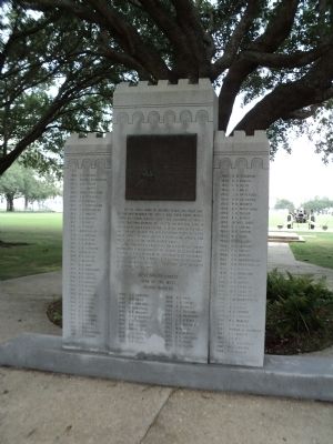
Erected by the United States 1932 In memory of the Garrison Defending Fort Sumter during the bombardment April 12-14, 1861 Major Robert Anderson First U.S. Artillery commandingCorps of Engineers Captain John G. Foster 1st Lieut. George . . . — — Map (db m30916) HM
Marion Square was once home to an extensive fortress that covered these public grounds and the surrounding area. Called the Horn Work, the name of the structure derived from its shape. Flanking the gateway on King Street were two . . . — — Map (db m242429) HM
An extensive fortress protected Charleston during the Revolutionary War. It was destroyed long ago, but remnants of its formidable tabby walls-cement made with oyster shells- lie just below the surface of these grounds. A fragment is preserved above . . . — — Map (db m242334) HM WM
This corner building was constructed shortly after the end of the Civil War under the ownership of Ireland-native Mary Monaghan Molony, widow of John Molony, who purchased the property in 1854. Earlier structures on the site were destroyed in The . . . — — Map (db m242591) HM
Historical records indicate that this three-story single house was constructed between 1800 and 1802 for cabinet maker Philip Moore. Prior to the building's construction, the property served as part of brewer Daniel Bourget's large estate, which was . . . — — Map (db m242594) HM
Launched in 1994, the international and inter-regional project “The Slave Route: Resistance, Liberty, Heritage” addresses the history of the slave trade and slavery through the prism of intercultural dialogue, a culture of peace and . . . — — Map (db m298160) HM
1812-WAR of 1812-1814 between the United States and Great Britain. This Company was mustered into active service.
1836-SEMINOLE WAR-The Washington Light Infantry was sent to St. Augustine for the protection of women and children. . . . — — Map (db m152765) HM
This three-story, masonry residence set on a raised basement was begun circa 1796 by Mrs. Frances Motte Middleton, daughter of Jacob and Rebecca Motte. The house was completed by Mrs. Middleton and her second husband and former brother-in-law, . . . — — Map (db m51273) HM
Firefighting in Charleston Fires, earthquakes, tornados, hurricanes, and epidemics… although Charleston has faced many kinds of disasters over its long history, fire has had the greatest impact on the city.
In 1698 a great fire swept . . . — — Map (db m135500) HM
This Charleston double house was built before 1789 by William Blake, a planter and descendant of former Proprietary Governor Joseph Blake. By 1803 Mary Smith Grimké, descendant of Landgrave Thomas Smith, and Judge John F. Grimké, a planter and . . . — — Map (db m133687) HM
This residence was constructed by Col. William Rhett (1666-1722), a prominent Charleston merchant and colonial militia leader. In 1706 he led a small fleet of local ships that repulsed a combined French and Spanish invasion of the city. Rhett is . . . — — Map (db m31849) HM
This substantial three-story Greek Revival Period Charleston single house is constructed of stucco-covered brick and features a two-tiered piazza with Tuscan columns and turned balusters, piazza screen and entrance door complete with pilasters, . . . — — Map (db m51485) HM
Founded 1818 by the Reverend Morris Brown
Closed by State Law 1834. Reopened By The Reverend R.H. Cain 1865
Present Edifice Built By The Reverend L.R. Nichols 1891
Redecoration By The Reverend F.R. Veal 1949
The Right Reverend F.M. Reid, . . . — — Map (db m219129) HM
Bicentennal
Historical Marker
Emanuel African Methodist Episcopal Church
Charleston, South Carolina
Commemorating the unique ministry of South Carolina born bishops, elected in the first century of the
Connection- . . . — — Map (db m52010) HM
The oldest African Methodist Episcopal (A.M.E.) church in the south, Emanuel A.M.E. Church was organized as
Hampstead Free African church in 1818 by Rev. Morris Brown. After seceding from the Methodist Church,
Charlestonians organized three . . . — — Map (db m51900) HM
Salvaged from the waters of the tidal zone around Fort Sumter, these bricks were placed in this wall 140 years after the beginning of the Civil War. — — Map (db m67310) HM
Fort Sumter, visible in the far distance of Charleston Harbor, looks very different today. Built after the War of 1812, its tow two tiers are gone, destroyed during the Civil War. The fort's center is now dominated by Battery Huger, a huge, black, . . . — — Map (db m47521) HM
The land now known as Liberty Square was once a place of arrival for survivors of the largest forced migration in world history. Gadsden's Wharf was the primary wharf for slave ships arriving in Charleston for 25 years, up until the banning of . . . — — Map (db m134227) HM
The National Register
of Historic Places
South Carolina
Department of Archives
And History
Charleston
Old E. Historic District
Harleston Boags Funeral Home
(Lower Plaque)
Harleston - Boags Funeral Home . . . — — Map (db m51484) HM
Eliza Jones (1775-1846) purchased this lot in the aftermath of the Ansonborough fire of 1838. She was the granddaughter of Robert Gibson, a graduate of Oxford University, and a Grand Master Mason, who, according to family legend, played a role in . . . — — Map (db m135489) HM
Philip Simmons is the most distinguished of Charleston ironworkers. Born on Daniel Island, Simmons began his eighty year career as a blacksmith at the age of thirteen under the apprenticeship of formerly enslaved Peter Simmons (no relation). Over . . . — — Map (db m134229) HM
Since 1670 this well-protected harbor has persisted as a center for shipping and trade. By 1770 Charleston was America's third busiest port; Gadsden's Wharf, located here, became its largest pier. Along this waterfront ships loaded cargo and . . . — — Map (db m47522) HM
Rice, Rattlesnakes, and Rainwater is a sculptural collection that explores the connections between Charleston's natural environment and its rich African-American history. The project consists of tabby (oyster-shell and concrete) houses and barrels . . . — — Map (db m135492) HM
Septima Poinsette Clark was born in Charleston, South Carolina in 1898, the daughter of Victoria Anderson of Haiti and Peter Poinsette, who grew up enslaved on the plantation of Joel Roberts Poinsette. Clark earned a teacher's certificate from The . . . — — Map (db m134228) HM
Native Charlestonian and daughter of a former lowcountry slave, Mrs. Septima Clark was a leader of the Civil Rights Movement. A graduate of Avery Normal Institute, Clark's first job was teaching African-American children on Johns Island. Her . . . — — Map (db m64797) HM
November 18, 1866 Bishop Patrick N. Lynch purchased a Jewish synagogue at 34 Wentworth Street and its adjacent property to establish a church for African American Catholics and approximately two years later he dedicated St. Peter's Catholic Church. . . . — — Map (db m31846) HM
1822 Organized as a place of worship for those
could not afford to rent pews in existing churches.
1824 Church built on Guingard St. as the first "free"
Church of the Episcopal Church in the United States. . . . — — Map (db m170910) HM
This significant single house was built by Benjamin DuPré, a French tailor, sometime after 1803. The entire area was known as “Gadsden’s Green” after Christopher Gadsden who divided this land into six wharf lots and 197 back lots, built a brick . . . — — Map (db m51826) HM
552 entries matched your criteria. The first 100 are listed above. Next 100 ⊳