"Came to the Sink of St Marys a dreary road, dessolate
as a frozen lake" - William Chamberlain, Aug 4, 1849
M.E.O. 1996
Guidebook available
Trails West Inc. P. O. Box 12035 Reno, Nevada 89510
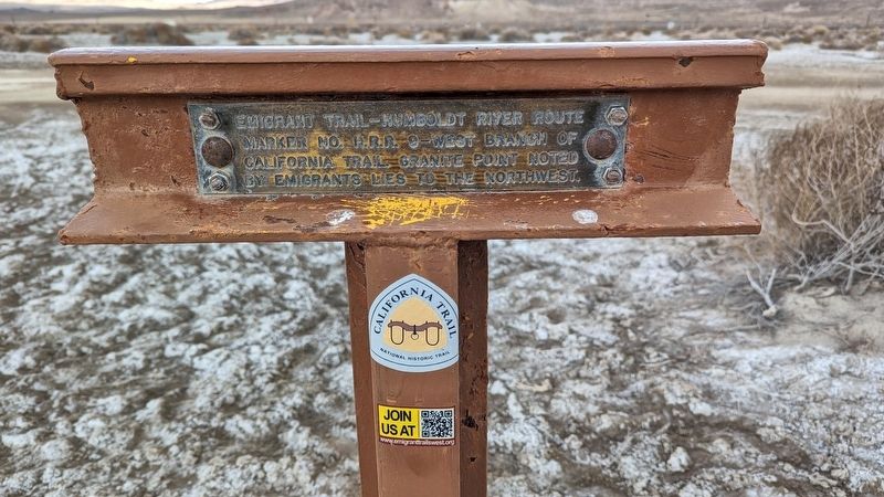
Emigrant Trail-Humboldt River Route . . . — — Map (db m264103) HM
Built in the late 1930s as "Red Rooster," later "Les Pyrenees Restaurant." Museum dedicated to those who lived, passed through and passed on here.
Recognized by Hampton Hotels Save-A-Landmark program as a site worth seeing — — Map (db m193155) HM
Overview of History
California Nursery Historical Park is 20 acres of prime agricultural land. People who inhabited the area included the Muwekma Ohlone, Spanish (Mission San Jose), Mexicans (Rancho Arroyo de la Alameda), and “Californios.” . . . — — Map (db m208723) HM
The Bank of California, a founding financier of the West, was established by William Chapman Ralston on July 5, 1864, the company quickly outgrew its quarters at this location and engaged architects Walter Danforth Bliss and William Baker Faville to . . . — — Map (db m70832) HM
We honor California's Native American tribes who preserved their families, language, culture, and religion despite a history of great evils committed against them. They confronted state sponsored genocide, forced assimilation, family separation and . . . — — Map (db m266244) HM
The large hill to the north, which became known as “California Hill,” was climbed by thousands of covered wagon emigrants heading west between 1841 and 1860. Many were bound for Oregon. California became the destination of the majority of travelers . . . — — Map (db m51229) HM
On this site, the Virginia City Agency of the Bank of California was established on September 6, 1864.
Here miners obtained the capital that financed the most spectacular boom in mining history. Nearly one billion dollars in gold and silver . . . — — Map (db m21540) HM
(Left Side of Base Holding Bell)
Only battleship
built on the
Pacific Coast
Launched at
Mare Island
Navy Yard
Nov. 20, 1919
Ship’s bell
dedicated and
rung for the
last time by
Governor
Earl Warren
Oct. 27, 1949
. . . — — Map (db m70035) HM WM
Forty-eight men of diverse education and cultural backgrounds from throughout California converged upon Monterey in September in 1849 to frame a constitutional government for California. Working together as Californians, they created this . . . — — Map (db m63348) HM
University of California, chartered March 23, 1868. Located between Franklin and Harrison, 12th and 14th Streets, from 1869 to 1873, using buildings of former College of California, successor to Contra Costa Academy founded by Henry Durant, June . . . — — Map (db m100544) HM
Junípero Serra
Serra played a decisive role in the European settlement of the New World. He was born Miquel José Serra in Petra on the Mediterranean island of Mallorca on November 24, 1713. Though not an assuming figure and plagued by ill . . . — — Map (db m143467) HM
Presentada por La Sociedad Aguacatera De California
en el 1946
En reconocimiento y aprecio por la gran contribución
de Antigua y toda Guatemala por el desarrollo de la
industria de aguacates en California.
Un jóven saludable, . . . — — Map (db m71194) HM
The California State Geological Society started collecting mineral specimens in 1865. In 1880, the California State Mining Bureau was founded. This plaque is dedicated to the miners and founders for their foresight. Todays collection displays . . . — — Map (db m46845) HM
About 60 feet above this marker a line of rocks marks the old Trappers and Emigrants Trail from Trinity River to Scott Valley. This route may have been used as early as 1829 by Hudson’s Bay trappers and others prior to the building of this road in . . . — — Map (db m57898) HM
These landmarks form the historic core of the first University of California campus, opened in 1873: Founders’ Rock, University House, Faculty Club and Glade, Hearst Greek Theatre, Hearst Memorial Mining Building, Doe Library, Sather Tower and . . . — — Map (db m290973) HM
The Great Seal of the State of California
designed by
Major Robert Selden Garnett,
U.S. Army,
and adopted by the Constitutional
Convention of 1849 at Monterey.
Commissioned a Brigadier General
in the Confederate States Army
He . . . — — Map (db m33659) HM
The Midwinter Exposition covered 160 acres and opened officially on January 27, 1894. 180 structures representing all California Counties, 4 other states, the Arizona Territory, and 18 foreign nations and villages, including a Japanese Village, . . . — — Map (db m132056) HM
The 1st California was one of four regiments that made up the “California Brigade” commanded by Colonel Edward D. Baker, U.S. Senator from Oregon and close friend of President Lincoln. In April, 1861, Baker helped to organize what was . . . — — Map (db m2230) HM
The California Cotton Mill was one of Oakland’s earliest and largest industries.
Jingletown was named for the mill workers’ habit of jingling coins in their pockets on payday.
At its height, the mill had 600 to 700 employees and 20 to 30 . . . — — Map (db m71211) HM
The historic Capitol was designed by architects M.F. Butler and Reuben Clark. Its style is an adaption of Roman Corinthian architecture. Work began in 1860 and by late 1869 the Capitol was partly occupied. In 1874, construction ended at a cost of . . . — — Map (db m154357) HM
Dedicated to All Veterans Who Answered the Call
to Serve this Great Nation
Northern California Veterans Cemetery
Igo, California
Dedicated November 11, 2005
Arnold Schwarzenegger, Governor
Thomas Johnson, Secretary . . . — — Map (db m63324) WM
The Bidwell-Bartleson Party
In 1841, John Bidwell and John Bartleson became the first Americans emigrants to undertake a wagon crossing from Missouri to California.
Although Oregon was the primary destination of early westward-bound . . . — — Map (db m140278) HM
The California Almond Growers Exchange founded in 1910, was first successful grower-owned co-operative for marketing California almonds. It pioneered in many fields, including almond production, mechanization and marketing. The first structure on . . . — — Map (db m11862) HM
Black Americans In The Golden State
Africans have had a presence and stake in California since before there was a California. Some 300 Africans accompanied the Spanish conquistador Hernan Cortes to the New World in 1519. And more than two . . . — — Map (db m216966) HM
James Williams
California Pioneer
James Williams, age 29 and a native of Cape Girardeau, Missouri, emigrated overland to California in 1843 along with his three brothers – John, age 25; Isaac, age 20; and Squire, age 19 – in a . . . — — Map (db m62440) HM
The primary purpose of the California Nursery Historical Park Master Plan is to tell the story of the California Nursery Company to current and future generations through the sharing of the site’s remaining historic buildings, majestic . . . — — Map (db m208557) HM
"California is one of the richest repositories of Native American rock art in North America.
Rock art - is an inclusive term for symbols created on natural rock surface.
pictograph - painted rock art.
petroglyph - . . . — — Map (db m205837) HM
Isamu Noguchi was commissioned to design a 1.6 acre public garden to enhance two office towers built on family land once used as a lima bean farm. California Scenario, an abstract metaphor of California's diverse natural environment, is considered . . . — — Map (db m308074) HM
A 3 foot narrow gauge railroad starting on land owned by Joseph E. Emery, later president and founder of the City of Emeryville.
The line started at 40th and San Pablo, extended through Berkeley and up San Pablo Creek to Bryant (Orinda) 23 . . . — — Map (db m72398) HM
CCT 24 was originally built for the famous Santa Fe Railway as part of its first order of all steel cabooses. Built in St. Charles, Missouri by American Car and Foundry, the 24 was part of the same class of cars as ATSF 999197, another caboose that . . . — — Map (db m163302) HM
If you had stood on this spot in 1769, 1823, and 1848, you would have been in three different countries! Each time California switched hands, life changed for its people.
Spanish Province
“California” was a Spanish province in 1769. For the . . . — — Map (db m214606) HM
Original Marker - Missing
First Replacement Marker - See Photo #2
Pilot Hill Grange No.1, of 29 charter members: Master, F. D. Brown; Secretary, A. J. Bayley; was organized August 10, 1870. The Grange Hall, dedicated at this site . . . — — Map (db m11607) HM
Commemorating the 100th anniversary of the founding in the Plaza area of the first gas service in Southern California June 28, 1867. — — Map (db m162929) HM
Originally planted in 1959 with California natives, the 1.5-acre
garden and greenhouse complex is now a collection of some 1,200
plant species representing many regions and climates from around
the world. In addition to exotic plants, it contains . . . — — Map (db m220283) HM
In the 1940s Jane S. Pinheiro, a local resident and self-taught wildflower artist, became concerned that rapid growth in the Antelope Valley was
endangering wildflower fields. Jane's dream was to have a "Poppy Park" to protect the official . . . — — Map (db m189239) HM
Near here on May 28, 1849, was the camp of a large party of gold seekers en route to California with a military escort under the command of Captain R. B. Marcy. The California Road was used by travelers for over 50 years. East of here about 4 miles . . . — — Map (db m39802) HM
Water for the Old Faithful Geyser of California comes from an underground river that is 350°F (177°C) and lives 2 miles below the earth's surface. When it flows over the hot molten magma deep in the earth, it boils, expands and is collected in . . . — — Map (db m251278) HM
This marks the site of the first
public school in California
Erected in 1847 — Opened April 3, 1848
This commemorative marker was erected
in 1957 by the Grand Lodge of Free
and Accepted Masons of the State of California . . . — — Map (db m53965) HM
When USC was founded in 1880, there were few avenues open to ambitious young Angelenos, who sought training in the different professions. Aspiring physicians were forced to leave the region to attend medical school in other cities, and future . . . — — Map (db m234144) HM
Marker One:
Father Junipero Serra: 1713 - 1784
Founder of the Missions of California, this Franciscan priest was the first to bring the grape to California, beginning with the first vineyard planted at Mission San Diego in 1779. His . . . — — Map (db m231450) HM
Westport
Westport, along with Independence, was a major outfitting point for the Santa Fe, Oregon, and California Trails. Founded in 1834 by John C. McCoy and platted around the trading post he built the previous year, Westport's early . . . — — Map (db m50723) HM
The 1906 earthquake had devastating consequences for the California Academy of Sciences. Immediately following the earthquake, dedicated staff members were able to rush to the Academy before the fire arrived and saved one carload of precious . . . — — Map (db m132051) HM
These eucalyptus trees mark the route of the narrow gauge California and Nevada railroad chartered in 1884 to connect California to the Nevada mines.
Only 23 miles of track were completed by 1891 from Emeryville to Bryant now Orinda. In addition . . . — — Map (db m133653) HM
Soon after miners discovered gold in underground quartz veins, mills were brought in to process ore. Dating back to at least the 1500’s, the mills used heavy iron pounders called stamps to crush the rock. Each mill had a series of stamps equipped . . . — — Map (db m215022) HM
A 1533 expedition sent by Hernan Cortes discovered Baja California,
leading to the name "California" and the belief that it was the famed
Island of California which then appeared on maps of the era.
Exploration and Cartography
. . . — — Map (db m165827) HM
From the early 1840s to 1865 the Oregon-California Trail was the most important route for settlers traveling west. Wagon trains camped at the Iowa, Sac and Fox Mission to take advantage of the spring and the blacksmith. They were followed in the . . . — — Map (db m47930) HM
The California Road
Originally a trail through the lands of the Shawnee Indians, running west from Westport through present day Johnson and Douglas Counties, this route was used throughout the 1830's and 1840's by Indians, missionaries, and . . . — — Map (db m50612) HM
You are at the entrance to The National California Emigrant Trail Interpretive Center. The purpose of the center is to gather and display historical knowledge about the emigrants who made the trek to California in the 1840s, 1850s, and 1860s. . . . — — Map (db m67509) HM
[Panel 1:] Pioneer Monument
Sculptor, Frank Happersberger (1859-1932)
Dedicated to the City of San Francisco on November 29, 1894, the Pioneer Monument was a gift of philanthropist James Lick. Lick, who died in 1876, left . . . — — Map (db m32183) HM
History When Spanish governors ruled the California territory, its capital was moved from town to town between San Diego and Monterey. San Jose had already been designated the capital by the time California was granted statehood in 1850. In . . . — — Map (db m137646) HM
Built for the 1915 Panama-California Exposition, the Plaza de California and its surrounding buildings created a grand entrance to the Exposition, announced by the ornate west archway. The California Building and Tower stand at the north, while the . . . — — Map (db m127568) HM
On this site was organized by the Rev. Sylvester Woodbridge, Jr., on April 15, 1849 the First Presbyterian Church of Benicia. This was the first protestant church established in California with an ordained resident pastor. The church of disbanded in . . . — — Map (db m95697) HM
In 1870, the year in which the Groezinger Winery (now Vintage 1870) was built, these flags: the California Bear flag (note how much more primitive in design it is in contrast with the present day version) and the American flag (then with 37 . . . — — Map (db m103540) HM
Since statehood, the people of California have sought and cherished a quality of life unsurpassed in this great nation. There have been among us those who chose to serve as peace officers and when called upon unselfishly gave more than we have the . . . — — Map (db m14814) HM
In commemoration of the Inauguration of the California Midwinter International Exposition
On this spot the first shovelfull of earth was turned
With ceremonies on August 24th, 1893. — — Map (db m233017) HM
Beginning in 1849, there plodded up the southern slope of Mount Oread a vast emigration bound for the golden land of California. One branch of the great California and Oregon Trail thus passed over the very ground now part of the university . . . — — Map (db m77573) HM
From Inner Spaces To Outer Space
The nation was celebrating
the tenth anniversary of the
Wright Brothers' powered
flight when the State Exposition Building first opened
in Exposition Park in 1913 — a place that
would become an . . . — — Map (db m233940) HM
A statewide network of Marine Protected Areas (MPAs) safeguards California's rich coastal resources. San Diego-Scripps SMCA, the first marine protected area in the state, was established in 1929 as the San Diego Marine Life Refuge. It surrounded the . . . — — Map (db m218330) HM
The Borough of California commemorates the establishment of California University of Pennsylvania of the State System of Higher Education, on this day July 1, 1983.
Mayor Joseph Dochinez
California Borough Council
Virginia . . . — — Map (db m202589) HM
Caravans of gold seekers in the Rush for California traveled this Trail in spring, 1849, under military escort commanded by Capt. R.B. Marcy. Route lay west from Ft. Smith, south side of Arkansas and Canadian rivers, across Oklahoma. Camp ground . . . — — Map (db m144810) HM
HISTORY
When Spanish governors ruled the California territory, its capitol was moved from town to town between San Diego and Monterey.
San Jose had already been designated the capitol by the time California was granted statehood in 1850. . . . — — Map (db m15017) HM
The first Masonic hall built in California was begun in the summer of 1850, occupied by the lodge October 14, 1850, and formally dedicated December 27, 1850. This building served as the Masonic Temple for Benicia Lodge No. 5 until 1888, when the . . . — — Map (db m16317) HM
The Russian-American Company grew crops and raised animals at Fort Ross to provide food for their Alaskan Colonies. In 1841, there were two windmills at Fort Ross. Grains, such as wheat, and barley, were ground into flour using millstones.
The . . . — — Map (db m85616) HM
Glenwood Canyon inspired the finest hour in American rail travel. During World War II a railroad official rode through here in the cab of a diesel freight locomotive. The view from the panoramic windshield so impressed him that he began steps to rig . . . — — Map (db m120140) HM
This Fountain
is Dedicated to
the Native Sons
of the Golden West
to Commemorate
the Admission of California
into the Union
September the Ninth
Anno Domini
MDCCCL
“The unity of our empire hangs on the decision of this day.” . . . — — Map (db m90968) HM
An ethnically diverse student body experienced a “Worker's Culture” here through painting, dance, music, theater, labor history and social science courses. Such artists as Anton Refregier, Ralph Stackpole, and Pablo O'Higgins taught . . . — — Map (db m91526) HM
Imported from Mazatlan, Mexico, the Mother Orange Tree was purchased on the streets of Sacramento when it was only a 2 to 3 year-old seedling in a tub. She was planted in 1856 and quickly grew into a California legend. The leafy greens of her robust . . . — — Map (db m62787) HM
On Oct. 25, 1882, the Veterans Home of California Association purchased 910 Acres in
Yountville for $17,750. On this site the first
building was erected.
Opened April 1, 1884 for Civil and Mexican
War veterans. By July 1, 1889, the Home . . . — — Map (db m144263) HM
Richard M. Nixon, the only native Californian elected to the Presidency of the United States of America, strongly believed in serving his community. His membership in the Native Sons of the Golden West reflected a lifelong devotion to public . . . — — Map (db m170611) HM
Each spring thousands of emigrants camped in these hills and meadows waiting for new grass to support their teams along the trail. Wagons lined St. Joseph streets to the east waiting for two to three days to be ferried from this point. The settlers . . . — — Map (db m47467) HM
The Most Beautiful Drive in America California's fabled road begins here in Dana Point and winds north along the scenic California coast linking waterside destinations, secluded stretches, and California's biggest cities. The road ends near . . . — — Map (db m256072) HM
From the 1830's to the 1870's, the 2,000-mile road connecting Missouri river towns with California and Oregon was America's greatest transcontinental highway. Several routes led west from the river, converging into one trail by the time the Fort . . . — — Map (db m80927) HM
This plaque commemorates the establishment of California University of Pennsylvania of the State System of Higher Education, on this day July 1, 1983
President John Pierce Watkins
Council of Trustees
Judy Ansill-Chairman • Donna . . . — — Map (db m201229) HM
In 1908 Elk Grove acquired through the efforts of Miss Harriet G. Eddy, then principal of Elk Grove Union High School, the first county free library branch in California. Subsequently, California's county free library branch system has become one of . . . — — Map (db m11868) HM
On this site
January 18, 1869
The California Theatre
Built by William C. Ralston
Opened with the following stock company
John McCullough • Lawrence Barrett • Harry Edwards • Willie Edouin • E.B. Holmes • William Mestayer • John T. . . . — — Map (db m143433) HM
1864
In the midst of the
Civil War, President
Abraham Lincoln
signs a law preserving
Yosemite Valley and
making it the nation's
first state park - it later
became a national park.
1890
Preservation . . . — — Map (db m235910) HM
Two plaques and a medallion are located at this site:
Oregon- California Trail
During the years 1841-1867 over 350,000 persons passed through Casper on their way West. The majority of them traveled through what is now the lobby . . . — — Map (db m92022) HM
California's First Theatre.
Monterey State Historic Park,
a California State Park.
For more information, go to our website: www.parks.ca.gov/mshp — — Map (db m239972) HM
Established in 1884 by Mexican War Veterans and members of the Grand Army of the Republic who recognized the need for a home for California’s aged and disabled veterans. In January 1897 the Veterans Home Association deeded the home and its 910 acres . . . — — Map (db m18743) HM
West of this point is the California Aqueduct which parallels Interstate Highway 5 for about 250 miles in the San Joaquin Valley. The aqueduct is a major part of the California State Water Project operated by the State Department of Water . . . — — Map (db m54686) HM
Hendy Stamp Mill
During the California Gold Rush, Hendy Iron Works built mining and stamp mill machinery exclusively. They supplied mining operations around the world with 5-stamp mills that could operate as a single unit or as multiple units . . . — — Map (db m30251) HM
In October of 1863, rich silver discoveries led to the formation of Montgomery Mining District and Montgomery City which, although short lived, supported a newspaper, The Pioneer. There were no continuous veins found and mining operations . . . — — Map (db m3492) HM
The Sacramento Valley Railroad running from Sacramento to Folsom, was begun at this site on February 12, 1855. Here, at Third and R Streets, was located the Sacramento passenger terminal. The turntable and freight depot were at Third and Front . . . — — Map (db m16056) HM
8814 entries matched your criteria. The first 100 are listed above. Next 100 ⊳
Thin black lines indicate changes in relevance. Between each pair of lines entries are ordered geographically but all have the same relevance.
* Inflectional forms of words are their plurals, singulars, and possessives as well as gramatical tenses and similar variations.