On U.S. 89 near Gomm's Pond Lane, on the right when traveling north.
Beginning in 1843, emigrants traveled across the continent along what became known as the Oregon Trail. Increased traffic during the 1850's resulted in the first government road construction project in the west. The 345 mile Central Division of the . . . — — Map (db m90521) HM
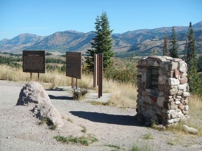
On Jackson Canyon Road near Wyoming Route 220, on the left when traveling west.
Oregon Trail approximately four miles north, on bend of North Platte visible to the north. Robert Stuart in 1812 erected the first white man's cabin in Wyoming. — — Map (db m164363) HM
Near Fort Caspar Road, 0.1 miles west of Wyoming Route 258, on the right when traveling west.
From 1840 to 1869, over 350,000 emigrants traveled past this area on the Oregon/California /Mormon Trails. The promise of free land, sudden riches, or religious freedom caused these pioneers to endure great hardships. Thousands of persons died in . . . — — Map (db m164516) HM
On South Center Street at East 1st Steet, on the right when traveling north on South Center Street.
Two plaques and a medallion are located at this site:
Oregon- California Trail
During the years 1841-1867 over 350,000 persons passed through Casper on their way West. The majority of them traveled through what is now the lobby . . . — — Map (db m92022) HM
Near S Guernsey Road, on the left when traveling south.
Dedicated to the pioneers of Wyoming Register Cliff acquired by the State of Wyoming through gift of the Henry Frederick family 1932 — — Map (db m86926) HM
Near Lucinda Rollins Road, on the right when traveling south.
has been designated a Registered National Historic Landmark Under the provisions of the Historic Sites Act of August 21, 1935 this site possesses exceptional value in commemorating or illustrating the history of the United States. U.S. Department . . . — — Map (db m86924) HM
Wagon wheels cut solid rock, carving a memorial to Empire Builders. what manner of men and beasts impelled conveyances weighting on those griding wheels? Look! A line of shadows crossing boundless wilderness.
Foremost, nimble mules drawing . . . — — Map (db m5748) HM
Near Lucinda Rollins Road near South Guernsey Road, on the left when traveling west.
Three panels are found at the Park Kiosk near the parking lot.
The Trail West
During the mid-1800s, more than 500,000 pioneers journeyed west. Never more than a rocky, rutted trail, the road west began in Missouri, crossing . . . — — Map (db m85924) HM
Cold Spring camping ground. Rifle pits on brow of hill 500 feet north. Erected by the Historical Landmark Commission of Wyoming 1943 — — Map (db m86711) HM
Near Lucinda Rollins Road near South Guernsey Road, on the left when traveling west.
The U.S. Army's Role in Protecting the Oregon Trail in Wyoming 1842 to 1870
Lieutenant John C. Fremont led an expedition west in 1842 to map a route to Oregon Territory. The scout, Kit Carson, guided the expedition. Lieutenant . . . — — Map (db m85771) HM
Near Lucinda Rollins Road near South Guernsey Road, on the left when traveling west.
Three plaques, under the same title, describe how the U.S. Army protected immigrants on the Oregon Trail.
Panel 1:
“If it is in contemplation to keep open communications with Oregon Territory, a show of military force in this . . . — — Map (db m85766) HM
On U.S. 191, 1.8 miles west of Wyoming Highway 351, on the right when traveling east.
This site is a crossing of the Lander Cut-off, the northern fork of the Oregon Trail. Originally called the Fort Kearney-South Pass-Honey Lake Wagon Road when it opened in 1858, it was the first federally-funded road project west of the Mississippi . . . — — Map (db m47092) HM
On W. Flaming Gorge Way (State Highway 374) at Center Street, on the right when traveling west on W. Flaming Gorge Way.
To All Pioneers
Who Passed
This Way
To Win And Hold
The West
Trail Crossed
30 Miles North
This Point
Erected By
People Of
Green River 1931 — — Map (db m67775) HM
This is the location of the junction of the original 1846 route of the Applegate Trail and the 1853 realignment of the trail as laid out by road engineers from Siskiyou County. The original route goes due east from this point and its traces are no . . . — — Map (db m152261) HM
On Crowder Flat Rd (Forest Road 73), on the right when traveling south.
The 1846 Applegate Trail, also known as the South Road to Oregon, lies behind this sign and heads westward along the banks of Fletcher Creek. It leaves Fletcher Creek after about two miles and then swings around the southern flank of Blue Mountain. . . . — — Map (db m152283) HM
On State Highway 21 at East Lake Forest Drive, on the right when traveling east on State Highway 21.
From the high ridge above the Boise River 5 miles southwest of here, westward-bound travelers got their first view of the Boise Valley. In 1811, Wilson Price Hunt and the Overland Astorians' party were the first white sojourners to enjoy the scene. . . . — — Map (db m119002) HM
On State Highway 21 at East Lake Forest Drive, on the right when traveling east on State Highway 21.
In 1906, at the age of seventy-five, Ezra Meeker began a journey east from his home in Puyallup, Washington, to retrace the route of the Oregon Trail over which he originally traveled in 1852 with his wife and young son. He traveled the route with . . . — — Map (db m118993) HM
On State Highway 21 at East Lake Forest Drive, on the right when traveling east on State Highway 21.
Concern for the safety of westward-bound emigrants became more immediate when news of the Utter party's disastrous confrontation with hostile Indians on September 9 and 10, 1860, reached western settlements. Colonel George Wright, commander of . . . — — Map (db m119004) HM
On State Highway 21 at East Lake Forest Drive, on the right when traveling east on State Highway 21.
Westward-bound emigrants entered Idaho after crossing Thomas Fork Valley. They soon encountered the climb and descent of Big Hill, witnessed nature's curiosities at Soda Springs, and discovered willing traders at Fort Hall.
In 1843 wagons . . . — — Map (db m118992) HM
On U.S. 21 at East Lake Forest Drive, on the right when traveling north on U.S. 21.
After the transcontinental railroad was completed on May 10, 1869, new stage and freight routes were established to connect southwester Idaho with newly established railheads.
Kelton, Utah, soon became the main shipping point for Boise, when John . . . — — Map (db m118996) HM
On South Main Street at East 2nd South, on the left when traveling south on South Main Street.
U.S.A. Cavalry Infantry
53 families and others
Founded Soda Springs
Built fort to protect emigrants
County seat Oneida County
1864 ---- 1867 — — Map (db m124492) HM
Stretching from Independence, Missouri, to Oregon City, the two thousand mile Oregon Trail lured over 300,000 pioneers on a long six month journey. When pioneers entered present-day Idaho, many had traveled more than one thousand miles of hot, dusty . . . — — Map (db m125674) HM
On West Madison Avenue near South Owyhee Street, on the left when traveling west.
Thursday July 24
"Traveled 13 miles struck the river 2 miles above the ford. Here we found a company ferrying in wagon beds we unloaded two our best wagon beds and commenced calking them got them finished and ferried their loads that . . . — — Map (db m125677) HM
On Hot Springs Road at Teapot Road/Ross Road, on the right when traveling west on Hot Springs Road.
Sunday July 27 "Traveled 15 miles 5 miles brought us to a marshy hollow (Hot Springs Creek) which wound to right of the direction were traveling. Traveled in this marsh 3 miles then drove out leaving this marsh to our right..." -- Susan . . . — — Map (db m125751) HM
On Northeast Teapot Road near Worth Lee Road, on the right when traveling west.
Saturday August 16 "...we passed a hot springs near the foot of the same range, the water of which was nearly at a boiling temperature, so that one could not hold is finger in it, and a dog careless stepping across it put one foot in and ran . . . — — Map (db m125752) HM
Friday September 10th "...Traveled along the foot of the mountain about 5 miles to another creek and stopped for the night. Plenty of dry bunchgrass. No timber, but willows and sage. Found eight graves here. Made fifteen miles." Parthenia . . . — — Map (db m125754) HM
On Immigrant Road at Canyon Creek Road, on the right when traveling west on Immigrant Road.
August the 13th "...the road to day way level but very rocky A long chain of mountains on our right and we travel close to them to day..." -- Absolom B. Harden, 1847
After the transcontinental railroad was completed in 1869, . . . — — Map (db m125755) HM
On Canyon Creek/Mayfield Road near Memory Lane, on the right when traveling west.
August 4th "This day we traveled nineteen miles over tolerably rough road ... After watering, we traveled eight and a half miles, which brought us to a barrel creek (Canyon Creek). Here we found a small creek running through a barrel-shaped . . . — — Map (db m125756) HM
On Washington Street (Illinois Route 64) just east of South 5th Street, on the left when traveling west.
Oregon has a rich art and cultural heritage that dates back to the days of the Lincoln Highway. Seeking peace and quiet from the hectic life of the city, motorists were now able to enjoy weekends and summers in nearby rural areas. Located on the . . . — — Map (db m209417) HM
Near U.S. 56 at West 183rd Street, on the right when traveling west.
Heavy freight wagons lumbering to and from New Mexico, and emigrant families and gold seekers heading west to Oregon and California all shared this route from Independence and Kansas City. The trails split here at Gardner Junction.
Preserving . . . — — Map (db m131353) HM
Near U.S. 56 at West 183rd Street, on the right when traveling west.
From the late 1820s to the 1870s, an estimated 300,000 fur traders, missionaries, settlers, and gold seekers followed these trails. In the 1840s and 1850s, emigrants from the eastern and central United States walked 2,000 miles from the Missouri . . . — — Map (db m131376) HM
Under this bridge lies a part of Oregon Ridge's past. Around 1850 the small valley you see below, now covered in greenery and maturing trees, was an open quarry supplying ore to the Oregon Iron Furnace.
To learn more about the miners, the . . . — — Map (db m219258) HM
On West College Street at North McCoy Street, on the right when traveling west on West College Street.
Hiram Young came to Missouri as an enslaved African American. He earned his freedom step by step. First he purchased his wife Matilda's freedom in the early 1840s. For children to be free, they had to be born to a free mother. The Youngs welcomed . . . — — Map (db m208243) HM
On West College Street at North McCoy Street, on the right when traveling west on West College Street.
Being at leisure one day, I rode over to Independence [from Westport, in May 1846]. The town was crowded. A multitude of shops had sprang up to furnish the emigrants and Santa Fe traders with necessaries for the journey; and there was an . . . — — Map (db m208146) HM
On West College Street at North McCoy Street, on the left when traveling east on West College Street.
The entire country had railroad fever in the 1830s, with the dream that one day a railroad might span the continent! In Independence merchants needed to move goods between the town square and the Wayne City steamboat landing on the Missouri River - . . . — — Map (db m208135) HM
On West College Street at North McCoy Street, on the left when traveling east on West College Street.
People on steamboats loaded with goods traveled upstream on the Missouri River "highway" to Independence, where the overland journey on the Santa Fe, Oregon, and California trails began. Between March and November, steamboats passed by or stopped . . . — — Map (db m208241) HM
On West College Street at North McCoy Street, on the right when traveling west on West College Street.
The Santa Fe Trail began in 1821 when William Becknell took trade items west and found a ready market in Mexico. He passed through this area before the village of Independence was platted in 1827 as the county seat for newly formed Jackson County. . . . — — Map (db m208242) HM
On East Red Bridge Road, on the right when traveling west.
(This marker has two panels. From the left panel:)
Key Map
Traveling across this bridge, the fourth Red Bridge near this location since 1859, you may notice art panels attached to each of the large pillars that rise at both . . . — — Map (db m210568) HM
On Red Bridge Road east of Minor Park North Entrance, on the right when traveling east.
Visiting the Trails Today
The Santa Fe, Oregon and California Trails had a significant role in the history of the United States and have been designated by Congress as National Historic Trails. The National Park Service partners with site . . . — — Map (db m199379) HM
On East Red Bridge Road east of East 110th Street, on the right when traveling east.
Why Did The Historic Trails Go Where They Went?
When Mexico won its independence from Spain in 1821, trade with the United States soon followed. William Becknell and five companions from the Franklin, Missouri area were the first to use . . . — — Map (db m199377) HM
Near Old Oregon Trail, on the right when traveling west. Reported permanently removed.
You are standing on the northern section of Scotts Bluff, looking across to the southern section. On the horizon the Wildcat Hills stretch far to the east (left). Below, the route of the Oregon Trail cuts through Mitchell Pass. A few traces of the . . . — — Map (db m156141) HM
On Old Oregon Trail Road, on the right when traveling west. Reported permanently removed.
The sight of Scotts Bluff thrilled emigrants journeying west on the Oregon Trail. After weeks of plodding across the wild and expansive plains, they were confronted by this massive promontory rising some 800 feet above the valley floor. The clay . . . — — Map (db m174219) HM
Near Old Oregon Trail, on the right when traveling west.
In the 1840’s and 50’s, thousands of pioneers followed the shallow Platte and North Platte Rivers across the plains on their way to Oregon and California. Covered wagons passed Scotts Bluff on both sides of the river. Emigrants could not lead . . . — — Map (db m87308) HM
Near Old Oregon Trail, on the right when traveling west. Reported permanently removed.
Out on the prairie, wagons following the Oregon Trail spread out to avoid the dust stirred up by wagons in front. But here at Mitchell Pass the emigrants encountered a difficult bottleneck where wagons had to squeeze through narrow ravines in . . . — — Map (db m174342) HM
Near Campbell Street near Sunridge Lane, on the right when traveling west.
In October 1861, a group of prospectors in search of the mythical Blue Bucket Mine, made camp on a creek six miles southwest of here. That evening, Henry Griffin discovered gold in the gulch which bears his name. That started a stampede which . . . — — Map (db m108152) HM
On Main Street near Valley Avenue, on the left when traveling north.
The lot which this building occupies was first the location of a wood frame structure housing the McCord Brothers blacksmith shop. In 1867, Dr. J.M. Boyd and John W. Wisdom leased the structure to open Baker City’s first drug store. Wisdom continued . . . — — Map (db m108041) HM
On Dewey Avenue (Oregon Route 7) near Auburn Avenue, on the right when traveling north.
The Old Post Office building served as Baker City’s post office for 58 years, from completion of construction in 1910 until 1968, when the Post Office relocated to a new Federal Building a block to the south. The building also housed offices of the . . . — — Map (db m108042) HM
On Old U.S. 30 at Oxman Ranch Road, on the left when traveling west on Old U.S. 30.
This spot was famous in early days as Express Ranch an important relay station on the Umatilla-Boise Basin stage and freight route. It was also a favorite camping place for emigrants and teamsters. — — Map (db m108121) HM
Near Oregon Trail Boulevard (Business U.S. 30) near Frontage Road, on the right when traveling north.
The last camp on the weary journey across the Snake River plains. Here the Oregon Trail left the Snake River and wound overland to the Columbia. Here camped Wilson Price Hunt, December 23, 1811; Capt. Bonneville, January 10, 1834; Nathaniel J. . . . — — Map (db m107217) HM
On Mill Street (County Route 410) near Sumpter Street, on the right when traveling north.
Bank was established in 1899 with a capital stock of $10,000.00. The first officers were A.P. Goss, President and A.H. Goss, Cashier. The bank was destroyed by fire on August 13, 1917 and the vault is all that remains. — — Map (db m111241) HM
The Quest symbolizes Alice E. Biddle, who in 1870 became the first woman to graduate from what is now Oregon State University. It reflects the energy, dedication and strength of all students in the pursuit of learning. — — Map (db m113343) HM
On SW Avery Park Drive, on the left when traveling east.
(Seven panels dealing with topics related to the Applegate Trail are found at this kiosk.)
Applegate Trail
Southern Route to Oregon
In 1846, Jesse Applegate and fourteen others from near Dallas, Oregon, established a . . . — — Map (db m116846) HM
On Pacific Hwy (U.S. 99) at Main Street, on the right when traveling south on Pacific Hwy.
(Two interpretive displays are located here next to the South Benton Community Museum):
(First Display)
In 1846, Jesse Applegate and fourteen others from near Dallas, Oregon, established a trail south from the Willamette Valley and . . . — — Map (db m116837) HM
Near Mt. Hood Highway (Oregon Route 35), on the right when traveling east.
In 1924 engineers constructing the first Mt. Hood Highway discovered a gravesite here. The grave was marked with an old wooden wagon tongue buried beneath decades of overgrown brush. When they dug up the site, they found the remains of an emigrant . . . — — Map (db m113603) HM
Near Washington Street near Abernethy Road, on the right when traveling north.
About four miles below Oregon City the Klackamass enters the Walhamettee: and, seated below the banks at its mouth, I saw a party of Indians of the Klackamass tribe, and I put ashore for the purpose of taking a sketch of them.
They were busy . . . — — Map (db m114759) HM
Near Washington Street near Abernethy Road, on the right when traveling north.
"He stood among his pioneer contemporaries like towering old (Mount) Hood ... a born leader of men." -- Willard H Res, description of John McLoughlin during speech, 1879
His personality was measured in patience, generosity, . . . — — Map (db m114065) HM
On McLoughlin Boulevard (Oregon Route 99) at S. 2nd Street, on the right when traveling south on McLoughlin Boulevard.
Born in Riviere du Loup, Canada, October 19, 1784.
1824 Came to the Oregon Country as Chief Factor of the Columbia Department of the Hudson's Bay Company.
1829 Located his claim to the present site of Oregon City.
1845 Resigned his . . . — — Map (db m8699) HM
Near Washington Street near Abernethy Road, on the right when traveling north.
"We pitched our tent... remaining at this camp for about one week, feasting on watermelons and good, fresh vegetables right from the garden, which are brought in by the Clackamas County farmers in great abundance." E.W. Conyers on arrival in . . . — — Map (db m114201) HM
On Mt. Hood Highway (U.S. 26), on the left when traveling west.
The pioneer road here detoured the Columbia River rapids and Mount Hood to the Willamette Valley. The road at first followed an old Indian trail. The later name was Barlow Road. Travel was difficult. Wagons were snubbed to trees by ropes on held . . . — — Map (db m112372) HM
On Northbound Rest Area (Interstate 205), on the right when traveling north.
From 1845 to 1849, George Abernethy was the first Provisional Governor of the Oregon Country, which extended from the Pacific Ocean to the Rocky Mountains and from California to Northern British Columbia. After arriving in Oregon in 1840 as part of . . . — — Map (db m8670) HM
On Northbound Rest Area (Interstate 205), on the right when traveling north.
Was early the site of an Indian salmon fishing village. The falls furnished the power for a lumber mill which began operation in 1842, a flour mill in 1844, a woolen mill in 1864 and the first paper mill in the Pacific Northwest in 1867. The first . . . — — Map (db m113514) HM
On Northbound Rest Area (Interstate 205), on the right when traveling north.
Still in use below this point-were opened on New Years Day, 1873, when the steamer Maria Wilkins became the first vessel to navigate up the west end of Willamette Falls. Farming and shipping interests had long sought to eliminate expensive portages . . . — — Map (db m8667) HM
The Grove of the States includes a tree representing each state in the USA and the District of Columbia. The idea for the Grove of the States was conceived by Oregon Attorney General Robert Y. Thornton to honor the passage of Lady Bird Jonson's 1965 . . . — — Map (db m127210) HM
On 7th Street south of Duane Street, on the left when traveling south.
This grove of nine trees is a part of the original landscaping planted around the historic 1886 Queen Anne style house of Captain George Flavel. The grove consists of a giant sequoia, ginko, Camperdown elm, bay laurel, pear, and four cork elms. . . . — — Map (db m168306) HM
On Columbia River Highway (U.S. 30) near North Buck Way, on the right when traveling north. Reported missing.
Deer Island in the Columbia was named by the Lewis and Clark Expedition which stopped to dine here November 5, 1805 on its way down river. Homeward bound the explorers camped on the island on March 28,1806. Captain Clark recorded "This morning we . . . — — Map (db m194989) HM
On Columbia River Highway (U.S. 30) at SW Old Portland Road, on the left when traveling north on Columbia River Highway.
One of the Oregon Country’s most picturesque fur-traders, Thomas McKay is buried near Scappoose.
He was a daring leader, famous storyteller and could drive a nail with a rifle ball.
A Canadian, he arrived with the Astorians as a teen-age boy; . . . — — Map (db m114416) HM
On Central Oregon Highway (U.S. 20) near Spencer Wells Road (County Route 23), on the left when traveling east.
Ages ago a river flowed across the high desert country in the rock canyon several hundred yards beyond this marker. The prehistoric river drained a large Ice Age lake that formed from the blocking of normal drainage in the area by lava flows. The . . . — — Map (db m157842) HM
On NE 1st Street at SE Maple Street, on the left when traveling north on NE 1st Street.
In 1846, Jesse Applegate and fourteen others from near Dallas, Oregon, established a trail south from the Willamette Valley and east to Fort Hall. This route offered emigrants an alternative to the perilous “last leg” of the Oregon Trail . . . — — Map (db m116842) HM
On Umpqua Highway (Oregon Route 38) 4 miles west of Loon Lake Road, on the right when traveling west.
On August 8th, 1850, the schooner Samuel Roberts grounded on this bar during her maiden voyage to Scottsburg as part of the Klamath exploring expedition.
She was the first recorded American Vessel to navigate the Umpqua River.
While waiting . . . — — Map (db m113339) HM
On Umpqua Highway (Oregon Route 38) at Main Street, on the left when traveling west on Umpqua Highway.
Few Oregon communities have had a more colorful history than Scottsburg. It was named for Levi Scott, a pioneer of 1844, who homesteaded here and founded the town in 1850. There was a lower town at the head of tidewater on the Umpqua River which . . . — — Map (db m113510) HM
Fort Harney, on the former Malheur Indian Reservation, was named for Gen. Wm. S. Harney, who took command of the Military Department of Oregon, Sept. 13, 1858. The fort was established Aug. 10, 1867, and became a permanent Military Post. By order of . . . — — Map (db m63026) HM
On U.S. 20 at South Harney Road, on the right when traveling east on U.S. 20.
Weary Oregon Trail emigrants, eager to ease travel or gain mileage, often attempted cutoffs and shortcuts. While many of these alternate routes proved successful, others did not--they became roads to ruin for some and the end of the trail for . . . — — Map (db m63032) HM
At this location on December 17, 1887 at 5:04PM the Golden Spike was symbolically driven by Charles Crocker of the Southern Pacific Railroad. This final connection completed freight and passenger service around the nation.
Mileage 428.8 . . . — — Map (db m160778) HM
(Marker 1)
In the 1860s the view from this spot on Main street would have looked much different than it does today. During the the Gold Rush boom of the 1850s, Jacksonville's early merchants and shopkeepers located their businesses along . . . — — Map (db m112901) HM
On North 5th Street at East D Street, on the left when traveling north on North 5th Street.
Dedicated
the first Sunday in
January, 1855
First church built in
Rogue River Valley
Tablet placed by
Crater Lake Chapter
Daughters of
the American Revolution
1932
— — Map (db m91766) HM
Near U.S. 97, 0.4 miles south of SW Culver Highway, on the left when traveling north.
This park is named for Peter Skene Ogden, 1793-1854. In the fall of 1825, Ogden led a Hudston's Bay Company trapping party on the first recorded journey into central Oregon, crossing the country to the north and east into the Crooked River Valley . . . — — Map (db m67889) HM
An ancient trail passed through here as part of an extensive Indian trade network linking peoples of the Northern Great Basin and Columbia Plateau to those living west of the Cascades. Obsidian, bear grass, and slaves were transported over these . . . — — Map (db m36498) HM
Near Interstate 5 at milepost 62 near Merlin Road, on the right when traveling north.
The perilous last leg of the Oregon Trail down the Columbia River rapids took lives, including the sons of Jesse and Lindsay Applegate in 1843. The Applegate brothers and others vowed to look for an all-land route into Oregon from Fort Hall (in . . . — — Map (db m167270) HM
On I-5 Frontage Road at Ritchie Road, on the right when traveling north on I-5 Frontage Road.
The narrow gorge of Canyon Creek has long served as a travel corridor. Native Americans likely trekked this canyon for thousands of years. Alexander McLeod of the Hudson's Bay Company provided the first written account of the route in 1829, while . . . — — Map (db m112856) HM
On Sunny Valley Loop north of Interstate 5, on the left when traveling north.
In 1846, Jesse Applegate and fourteen others from near Dallas, Oregon, established a trail south from the Williamette Valley and east to Fort Hall. This route offered emigrants an alternative to the perilous “last leg” of the Oregon . . . — — Map (db m63155) HM
On Old State Highway 99 South at Front Street, on the left when traveling north on Old State Highway 99 South.
In 1846, Jesse Applegate and fourteen others from near Dallas, Oregon, established a trail south from the Willamette Valley and east to Fort Hall. This route offered emigrants an alternative to the perilous "last leg" of the Oregon Trail down the . . . — — Map (db m114488) HM
Very near here, on a warm spring day in 1945, six people-a woman and five children-were killed by a Japanese "balloon bomb," or Fugo. The party had arrived for a picnic when they discovered the deflated balloon. While they gathered around the . . . — — Map (db m112533) HM
In 1846, Jesse Applegate and fourteen others from near Dallas, Oregon, established a trail south from the Willamette Valley and east to Fort Hall. This route offered emigrants an alternative to the perilous "last leg" of the Oregon Trail down the . . . — — Map (db m112867) HM
In 1846, Jesse Applegate and fourteen others from near Dallas, Oregon, established a trail south from the Willamette Valley and east to Fort Hall. This route offered emigrants an alternative to the perilous “last leg” of the Oregon . . . — — Map (db m112707) HM
On Oregon Route 31 south of Old Fort Rock Road, on the left when traveling south.
Fort Rock is the remnant of a maar volcano or tuff ring, formed when rising basaltic magma encountered water and exploded violently. The exploded debris – called tuff – fell back to earth around the volcanic vent to form this . . . — — Map (db m113585) HM
On Fremont Hwy (U.S. 395), on the right when traveling south.
Behind you to the east is a steep cliff called Abert Rim, made of many layers of hardened lava flows. This 30-mile-long, 2,500-foot-high, steep cliff is an example of a fault scarp, produced over millenia by great blocks of rock tilting and moving . . . — — Map (db m112536) HM
On State Line Road, on the right when traveling west.
Marker on Left:
In 1846, Jesse Applegate and fourteen others from near Dallas, Oregon, established a trail south from the Willamette Valley and east to Fort Hall. This route offered emigrants an alternative to the perilous . . . — — Map (db m147032) HM
On Cheshire Ave at N Lincoln St, on the right when traveling west on Cheshire Ave.
(The following two of four interpretive displays located in this park highlight the Applegate Trail):
(First Display)
In 1846, Jesse Applegate and fourteen others from near Dallas, Oregon, established a trail south from the Willamette . . . — — Map (db m116803) HM
On Oregon Route 58 south of Edenvale Road, on the left when traveling north.
Elijah Bristow, a veteran of Andrew Jackson's army, erected his cabin here on Pleasant Hill in 1846, earliest year of settlement in Lane County. He and his wife Susannah then led in establishing the county's first church and first school. This . . . — — Map (db m99218) HM
On Yaquina Bay State Park Road west of Oregon Coast Highway (U.S. 101), on the left when traveling north.
The old Yaquina Bay Lighthouse established in 1871 is the earliest aid to navigation, standing within the range of the first recorded landfall made from a ship to the shores of the Pacific Northwest. Captain James Cook made this landfall on March . . . — — Map (db m113917) HM
1847 entries matched your criteria. Entries 201 through 300 are listed above. ⊲ Previous 100 — Next 100 ⊳
* Inflectional forms of words are their plurals, singulars, and possessives as well as gramatical tenses and similar variations.