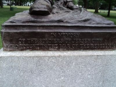
On Lincoln Park Road, on the left when traveling west.
In memory of the Soldiers of Jersey City who fought in the War of the Rebellion. [ Back of Monument: ] This monument is erected by the executor of the estate of the late Edward J. Donnelly, Sergt. Co. C, 5th N.J. Volunteers and a . . . — — Map (db m42406) HM
On Washington Boulevard at Town Square Place, on the right when traveling north on Washington Boulevard.
Southeast of this spot, the Half Moon anchored Sept. 11-12, 1609. Here, the community of Pavonia was established Jan. 10, 1630. Washington made this area the keystone of the campaign, 1776. Hamilton and his friends planned the city Feb. 22, 1804. — — Map (db m35586) HM
On Hudson Street 0.1 miles south of Essex Street, on the right when traveling south.
Liberty State Park, across the Morris Canal, features the majestic Central Railroad of New Jersey Terminal, hundreds of acres of green space, and the State's only ferry access to Ellis Island and the Statue of Liberty.
Once Neglected, Now . . . — — Map (db m239443) HM
On Grand Street west of Washington Street (County Road 627), on the right when traveling east.
1804
Designated as a public square by Alexander Hamilton & Associates of the Jersey Company.
1850s Originally named Washington Square Park.
1904
Battle of Paulus Hook Obilisk dedicated by the Daughters of the . . . — — Map (db m239401) HM
Near Montgomery Street just west of Barrow Street, on the left when traveling west.
In 1991, led by the Friends of Van Vorst Park, Inc., an unprecedented community empowerment movement began whereby over 450 residents worked together for many years to improve the park's public safety and beauty. The Friends of Van Vorst Park, Inc., . . . — — Map (db m239386) HM
On Summit Avenue (County Route 617) south of Magnolia Avenue, on the right when traveling north. Reported permanently removed.
Jersey City’s oldest building, the Newkirk House was erected circa 1690 a few blocks northeast of the nearby Dutch settlement of Bergen Square (1660). Occupied for two centuries by the Newkirk family, the sandstone structure was sold by . . . — — Map (db m156027) HM
Near Morris Pesin Drive, on the right when traveling east. Reported missing.
On the foggy, drizzly morning of June 13, 1958, Morris Pesin (1911-1992) made his historic 8 minute canoe trip to the Statue of Liberty with a Jersey Journal reporter to dramatize the close proximity of the Jersey City shoreline to Ms. . . . — — Map (db m126346) HM
“A life is not important except in the impact it has on other lives.”
Jack Roosevelt Robinson
1919–1972
Jack Roosevelt Robinson, the first African-American to break the color barrier in Major League Baseball, played in his . . . — — Map (db m6101) HM
On Belmont Avenue at West Side Avenue, on the left when traveling west on Belmont Avenue.
Hudson County’s great public work of the 1890’s was Hudson (now Kennedy) Boulevard, a 20-mile landscaped roadway running through the county. Construction caused the demolition or relocation of many buildings and was completed in 1895. The road . . . — — Map (db m42419) HM
On Montgomery Street at Bergen Avenue, on the left when traveling east on Montgomery Street.
In grateful memory of Right Reverend Monsignor Roger A. McGinley Priest and Patriot who by teaching and example raised the level of citizenship in our city, and by founding Saint Aedan’s Parish in 1912, serving as its pastor for twenty-four . . . — — Map (db m35589) HM
Near Ash Street at Hudson Terrace, on the left when traveling east.
Completed in 1859, the Northern connected Jersey City to Upper Piermont (today's Sparkill) and then to Piermont. By 1860, it branched west to Monsey. On May 21, 1870, along this route, known today as the Erie Path, the line was extended north from . . . — — Map (db m138616) HM
On Phillip Street, on the right when traveling west.
Henry Hudson’s “Half Moon” anchored off Communipaw in 1609. In 1633 the Dutch West India Company built the first house occupied by “John the Laugher.” A small colony of Dutch houses and farms developed along the shore where . . . — — Map (db m42415) HM
On Lincoln Park Road, on the right when traveling west.
to the Volunteer Fireman of Jersey City Erected through the bequest of Capt. Frederick T. Farrier as a token of the friendship and esteem in which he held his former associates in the Volunteer Fire Department. Edwin M. Farrier 1931 . . . — — Map (db m42413) HM
On Christopher Columbus Drive near Brunswick Street, on the right when traveling west.
Knights of Rizal ❖ The Organization The Knights of Rizal is a civic and patriotic organization that was established by law as an instrumentality by which the teachings of Philippine national hero, Dr. Jose Rizal, may be propagated . . . — — Map (db m302854) HM
On Grove Street north of Montgomery Street, on the right when traveling north.
(On Sculpture)
In Memoriam
Erected by the people of Hudson County to commemorate the valor of the soldiers sailors and marines of the Civil War
(On Plaque)
Soldiers' and Sailors' Monument
Memorial Day • May 30, 1899 . . . — — Map (db m302837) WM
On Bergen Avenue at Highland Avenue on Bergen Avenue.
The Old Bergen Church, a Dutch Reformed Church, is a classic blending of Greek Revival details and form, with New Jersey Dutch influences. Originally founded in 1662 at Bergen Avenue and Vroom Street, the church has undergone two rebuildings on this . . . — — Map (db m6137) HM
Sculptor James Earle Frazer Erected in 1930 by the Lincoln Association of Jersey City with contributions from the school children of Jersey City. Rededicated February 12, 2005 75th Anniversary [ Pedestal Inscription: ] Lincoln . . . — — Map (db m42408) HM
Near Washington Boulevard 0.1 miles east of Normandie Avenue, on the left when traveling east.
In Memoriam - U.S.S. Maine -
destroyed in Havana Harbor
February 15th 1898.
This tablet is cast from metal recovered from the U.S.S. Maine. — — Map (db m227337) HM WM
On Park Street, on the right when traveling north.
Built 1872 at “Demarests Station” on the Northern Railroad of New Jersey. Designed by noted architect J. Cleveland Cady, it was considered the “handsomest on the line.” The depot was built of Palisades stone quarried on the . . . — — Map (db m7508) HM
On Newark Avenue (County Route 639) at Jersey Avenue, on the right when traveling east on Newark Avenue.
William was born September 10, 1969. One of eight (8) children, William built his first piragua (snow cone) cart at the age of nine to become the youngest entrepreneur in Jersey City’s history. He served downtown for over fifteen years on hot . . . — — Map (db m302848) HM
On Van Vorst Street at Essex Street, on the right when traveling south on Van Vorst Street. Reported unreadable.
The Morris Canal was an engineering marvel. Created by manual labor, it was mainly intended to transport coal from Pennsylvania's anthracite coal fields to northern New Jersey's industries.
In 1831, the canal operated from Phillipsburg on . . . — — Map (db m239391) HM
On Main Street (West Virginia Route 74) just south of Collins Avenue, on the left when traveling north.
Constructed in two phases: east end construction circa 1883; east end remodeled and west end constructed circal 1900. The depot closed in 1974. The last passenger train passed through in the Spring of 1981.
Restoration began in the early . . . — — Map (db m42243) HM
Near West Park Drive west of Lakeview Drive when traveling west.
Prior to restoration, the Lincoln Park Wetland Restoration Project Area was a landfill covered in refuse and debris. The area was also cut off from the tides of the Hackensack River. These conditions allowed nuisance, exotic, and non-native plant . . . — — Map (db m289423) HM
Near West Park Drive west of Lakeview Drive when traveling west.
The Journey... The journey to the construction of the Lincoln Park Wetland Restoration Project has been long and varied throughout the past century. Many different concepts, visions, and plans have been developed for Lincoln Park West, although . . . — — Map (db m289418) HM
On Hamburg Turnpike (U.S. 202), on the right when traveling east.
This house, which is Wayne’s oldest, was built in 1695 by Ardent Schuyler, one of the leaders of the original settlement. William Colfax, who married Hester Schuyler in 1783, gave the house the Colfax name. — — Map (db m7704) HM
On Main Street (U.S. 206) at Church Street, on the left when traveling north on Main Street.
The Hill Memorial Headquarters of the Sussex County Historical Society
Built 1916 in Renaissance Revival style by gift of Joshua Hill. Dedicated June 8, 1917. Listed 1985 on State and National Historic Registers as the oldest Museum Building in . . . — — Map (db m8091) HM
On Winfield Scott Place, on the left when traveling south.
This monument dedicated to “Seven Astronauts” who died national heroes as members of the crew of the “Challenger” January 28, 1986 ------------------------------ Erected in their memory by the students of Elizabeth October . . . — — Map (db m40752) HM
The Statue of Liberty was the first statue designed by Bartholdi to be completed. Earlier, in the 1850s, while traveling in Egypt, the Nubia and Ethiopia, he designed an immense lighthouse for the opening of the Suez Canal in Egypt, but the design . . . — — Map (db m49315) HM
Near Battery Place near Robert F. Wagner Jr. Park, on the right when traveling south. Reported permanently removed.
Left: Ferries, Tugs and Tall Ships
Not so long ago, New Yorkers travelling overseas left from passenger terminals located on Manhattan’s west side piers. Steamship lines owned their own terminals, and the arrivals and departures of great . . . — — Map (db m134089) HM
Near Greene Street 0.1 miles south of Essex Street, on the left when traveling south.
Still existing today are the remnants of the Morris Canal, an artificial waterway constructed in the 19th century to connect the New Jersey counties between the Hudson and Delaware Rivers.
You Can Still See
The Sugar House, located just . . . — — Map (db m239444) HM
Near North 4th Street at East Washington Avenue, on the right when traveling north.
History of Baldwin Locomotive Works
The age of steam locomotives had it origin with the Baldwin Locomotive Works. Baldwin Locomotive Works of Philadelphia and later Eddystone, Pa, was one of the most successful builders of steam . . . — — Map (db m251528) HM
Near Audrey Zapp Drive, on the right when traveling east.
This terminal was completed in June, 1889 and became fully operational on October 6, 1889. For almost 80 years it served as the main passenger terminal for the Central Railroad Company of New Jersey at this strategic Jersey City waterfront . . . — — Map (db m13290) HM
On Hudson River Waterfront Walkway, on the right when traveling south.
This was the second giant clock to decorate the top of the Colgate company warehouse (nearby). This version, created in 1924, was removed and relocated after the company left Jersey City in 1988.
Why Eight Sides?
The clock is octagonal . . . — — Map (db m239407) HM
On Bohnert Place at Zazzette Street, on the left when traveling east on Bohnert Place.
Harvey Springstead was arguably the best known locomotive engineer to both passengers and employees of the New York Division of the Erie Railroad. Moving to our town in 1890 he was not only a respected engineer but also a community leader along . . . — — Map (db m192903) HM
Near Washington Street 0.1 miles south of Dudley Street, on the right when traveling north. Reported unreadable.
The Morris Canal's original shipping basin was constructed here after the 102-mile-long canal reached Jersey City in 1836. The canal, built between 1825 and 1836 and from Phillipsburg on the Delaware River to Jersey City, transported chiefly . . . — — Map (db m239449) HM
Near Montgomery Street west of Barrow Street, on the left when traveling west.
Cornelius Van Vorst gave this hilly land to the Township of Bergen in 1835. He graded, landscaped and fenced it in 1851. From 1841 to 1856, this was Van Vorst Township. In latter years, it merged with Jersey City. Brownstones around this park built . . . — — Map (db m239384) HM
On Sip Avenue at Newkirk Street, on the right when traveling east on Sip Avenue.
In 1660, as the last Dutch Director-General of the colony of New Netherland, Stuyvesant was instrumental in the establishment of the Village of Bergen, which was near this site. The Scottish-American sculptor J. Massey Rhind was commissioned to . . . — — Map (db m100143) HM
On Main Street at East Street, on the left when traveling east on Main Street.
Built west from Elizabeth and Jersey City in the 1830s, reaching Easton in 1852. This stop spawned the town of Clinton Station, renamed Annandale in 1873. — — Map (db m16926) HM
On Wanaque Avenue at Cannonball Road, on the left when traveling south on Wanaque Avenue.
Replaced the original train station which was situated on the north side of the tracks. The New York, Susquehanna and Western lines which passed through Pompton Lakes came from Jersey City and went to Wilkes-Barre, Pennsylvania and Middletown, New . . . — — Map (db m40538) HM
On Lake Road (County Route 80) at Burnside Avenue, on the right when traveling west on Lake Road.
In 1880 the fledgling Jersey City & Albany Railway Co. completed a track through this area on easements granted by Abraham and Mary Conger, large landholders and prominent citizens. In 1883 a new railroad timetable listed the stop as . . . — — Map (db m44285) HM
On Bergen Avenue at Montgomery Street, on the left when traveling south on Bergen Avenue.
In Memoriam - U.S.S. Maine - Destroyed in Havana Harbor February 15, 1898.
This tablet is cast from metal recovered from the U.S.S. Maine.
Presented to the People of Jersey City, N.J. by General Joseph Wheeler - Post No. 4 A.V.F.S. . . . — — Map (db m6102) WM
On Main Street (County Route 624) at Plane Street, on the left when traveling west on Main Street.
Near this location, over 100 years ago, canal boats heavily laden with Pennsylvania coal were approaching the summit of Morris Canal Plane 7 East.
Much like a canal “lock”, an inclined plane is a simple machine which allows boats . . . — — Map (db m88949) HM
Constructed 1859-1865 for the Central Railroad of New Jersey, this 112 foot earthen embankment double arch culvert supports the original bridge from which the Borough of High Bridge is named. — — Map (db m5040) HM
On North Walnut Street at East 3rd Street on North Walnut Street.
Organized about the year 1769. Early meetings held in academy woods, Gilpin’s Wharf and Thelwell’s School. Church Built in 1789.
Dedicated to Bishop Francis Asbury. Here is buried Allen McLane, Lieutenant in Caesar Rodney’s Regiment 1779; . . . — — Map (db m92275) HM
Reflecting the need for additional river crossings as the area grew in the late 19th century, the contract for the original bridge was awarded in July 1890 to Riverside Bridge and Iron Works of Paterson, N.J. for $8,895. This original bridge was . . . — — Map (db m62435) HM
Near Audrey Zapp Drive, on the right when traveling east.
After passing the Statue of Liberty and being processed at Ellis Island, where did the new Americans go? Once declared “clearly and beyond a doubt, entitled to land” almost two-thirds of the immigrants processed at Ellis Island . . . — — Map (db m49339) HM
Near Washington Street 0.1 miles south of Dudley Street, on the left when traveling south.
By the late 1850s, the original canal basin (the "Little Basin") proved to small to handle the growing canal traffic. To the south of it, the Big Basin was constructed in 1859. Canal traffic continued to increase during the Civil War years and . . . — — Map (db m239451) HM
In the decades following the War of 1812, Fort Gibson continued to be used as a military installation. Large magazines were built to store explosive black powder, which was too unstable to be kept at the Navy Yard in Brooklyn. During the Civil War, . . . — — Map (db m49335) HM
Near 34th Avenue Northeast 0.2 miles east of North Broadway (U.S. 83), on the right when traveling east.
On December 12, 1944, a B-17 Bomber on a training flight from the Army Air Base at Sioux City, Iowa, crashed while attempting an emergency landing at the Minot Airfield. Five of the crewmen perished in that tragic mishap. This memorial plaque is . . . — — Map (db m240917) HM
On Noble Street at North 13th Street, on the right when traveling east on Noble Street.
In Pennsylvania's rolling hills lay the resources to fuel the Industrial Revolution. Coal and iron ore rode the rails to factories, foundries and faraway cities. Philadelphia became the "workshop of the world," sending products to Delaware River . . . — — Map (db m214199) HM
On Pollitt Drive at Fair Lawn Ave. on Pollitt Drive.
Radburn Station, located in the Borough of Fair Lawn, was built in 1930 and designed by the architect Clarence S. Stein. Stylistically, the building is significant since the station is a fine example of the Dutch Colonial Revival trend in . . . — — Map (db m62968) HM
On Kinderkamack Road (County Route 503) at Soldier Hill Road, on the left when traveling north on Kinderkamack Road.
The Continental Army advanced to Englewood on August 23, 1780, with some units foraging as far south as Jersey City. The main body of the army moved west of the Hackensack River on September 4th, camping in two lines west of Kinderkamack Road, one . . . — — Map (db m7552) HM
On Grand Street just west of Washington Street (County Road 627), on the left when traveling west.
105 Grand Street
Greek Revival Townhouse
Built Circa 1837
by Dudley S. Gregory
First Mayor of Jersey City
The land was formerly owned by
Robert Fulton
inventor of the steamboat
Listed on the
National Register . . . — — Map (db m239398) HM
Near Emmans Road at Canal Street, on the left when traveling north.
The Morris Canal was an engineering marvel of its time. A system of 23 lift locks and 23 inclined planes enabled the canal to overcome more elevation change than any other transportation canal ever built. Large changes in elevation were . . . — — Map (db m33270) HM
Near Waterloo Valley Road, on the right when traveling east.
The Morris Canal was an engineering marvel of its time. A system of 23 lift locks and 23 inclined planes enabled the canal to overcome more elevation change than any other transportation canal ever built. Large changes in elevation were . . . — — Map (db m99051) HM
The most spectacular view from Pier 76 is facing south, where the iconic skyline of lower Manhattan rises next to New York Harbor landmarks like the Statue of Liberty and Freedom Tower. The city owes its success to this harbor, which was first . . . — — Map (db m228805) HM
The most spectacular view from Pier 76 is facing south, where the iconic skyline of lower Manhattan rises next to New York Harbor landmarks like the Statue of Liberty and Freedom Tower. The city owes its success to this harbor, which was first . . . — — Map (db m228802) HM
On Old Haverstraw Rd. 0.1 miles south of New York State Route 304.
Proclaimed by royal decree almost three centuries ago this onetime Indian trail wound its way northward through Long Clove to the Hudson River below. Kings Highway's original purpose was military as the English Crown feared invasion by the French . . . — — Map (db m84080) HM
The Tappan Indians, from time immemorial, occupied these lands fronting on the river shore. Here, in summer, they lived upon the fish and oysters which the waters produced in abundance. In the Algonkian dialect, spoken by them, they called this . . . — — Map (db m44310) HM
Near Gap Road (Pennsylvania Route 741) east of Bishop Road, on the right when traveling east.
Builder: Budd Company, Red Lion, PA Build Date: 1937 Retirement Date: 1982 Number Built: 2 Weight: 97,000 lbs. Length: 85 ft. PHMC Cat No. RR78.52 The Crusader: As the nation pulled itself out of the Great Depression, the Reading Company . . . — — Map (db m19967) HM
Near Parker Avenue (New York State Route 9G) 0.2 miles east of Washington Street ( Route 9G), on the left when traveling east.
Although the river dates back some 60 million years, the river we see today was shaped during the last Ice Age. About 16,000 years ago, a massive ice field gouged the riverbed to a depth below sea level, thus allowing water from the Atlantic Ocean . . . — — Map (db m142780) HM
On Maywood Avenue south of West Central Avenue, on the right when traveling south.
Maywood Station, located in the Borough of Maywood, Bergen County, New Jersey was built in March 1872. Stylistically, the building is significant as the station is a fine example of Railroad Architecture with Carpenter Gothic features. The . . . — — Map (db m291239) HM
On Main Street (Old New Bridge Road), on the left when traveling west.
Site of:Hackensack Indian Village, and The Real George Washington Bridge This 10½ acre park named after Teaneck Mayor and open space advocate Clarence “Jim” Brett is one of the most historically significant site in Teaneck, indeed . . . — — Map (db m40228) HM
Born May 16, 1810 in Staffordshire, England.
Taylor came to the United States in 1829 and settled for a time in Jersey City. He worked in the potteries of Troy, Indiana; Orrsville, Kentucky; Cincinnati, Ohio, and East Liverpool, Ohio, to . . . — — Map (db m4465) HM
On Albany Street at Easton Avenue on Albany Street.
Date 1903
William H. Brown, Engineer
The New Jersey Railroad, chartered in 1832, was completed between Jersey City and New Brunswick in 1835. On January 2, 1836, the first train, a new locomotive named "The New Brunswick" traveled down from . . . — — Map (db m95769) HM
On Millville Road at River Road (County Route 521), in the median on Millville Road.
Block House Hill - Block house during French and Indian War.
Home of Capt. Shimer - across this way.
End of Jersey City-Milford Turnpike one mile south.
Brick House built 1776 - one and one-half miles south.
Minisink Church, . . . — — Map (db m231581) HM
On Tower Avenue at Burgoyne Road / Rogers Street, on the right when traveling north on Tower Avenue.
In 1756 the French erected a mill on the river opposite this spot for sawing and preparing timbers used in Fort Carillon, renamed Fort Ticonderoga when captured by General Amherst in 1759.
General Abercromby used the saw mill as his headquarters . . . — — Map (db m125190) HM
On West San Antonio Avenue east of West Paisano Drive (U.S. 85), on the right when traveling east.
One of the oldest survivors of America's steam railroading era, this locomotive was built 29 years after the steam engine was first developed for transportation. Breese, Kneeland & Company of Jersey City, New Jersey also operated as the New York . . . — — Map (db m37851) HM
On W. Ridgewood Avenue at Garber Square, on the left when traveling east on W. Ridgewood Avenue.
Ridgewood Station
Date: 1916
W. W. Drinker and Frank A. Howard, Engineers
Ridgewood Station is a fine, and possibly unique (for New Jersey) example of the Mission Revival style, first popularized in California during the 1890's. Distinctive . . . — — Map (db m108051) HM
Near Clinton Street west of South Delaware Avenue, on the right when traveling south.
"Take it to the top. The world's out there waiting, and it's yours for the taking."
- Kool & the Gang
Founded: 1964
Lived in: Jersey City, New Jersey
Inducted to New Jersey Hall of Fame: . . . — — Map (db m220954) HM
You are standing on a site which saw one of the worse acts of sabotage in American history!
Prior to the U.S. entering WWI, the shoreline on which you now stand was occupied by an extensive munitions depot operated by the Lehigh Valley . . . — — Map (db m126349) HM
On Audrey Zapp Drive, on the right when traveling east.
New Jersey Central Jersey Central Lines Honoring the employees of the Central Railroad of New Jersey 1849 – 1976 Dedicated by the Central Railroad of New Jersey Veteran Employees Association — — Map (db m51512) HM
On Hudson Street at Essex Street, on the right when traveling south on Hudson Street.
In 1822 George P McCulloh, a Morristown businessman conceived the idea for the Morris Canal.
The canal would cross the State of New Jersey from the Hudson River at Jersey City to the Delaware River at Phillipsburg.
Rising a total of 914 . . . — — Map (db m239442) HM
On North Park Drive near School Street, on the right when traveling west.
On the rainy Tuesday evening of February 6, 1951, a crowded rush-hour express train departed from Exchange Place in Jersey City headed toward Bayhead in New Jersey. “The Broker”, named for the many Wall Street employees it . . . — — Map (db m125813) HM
On U.S. 202 0.1 miles east of Barney Lane, on the right when traveling east.
Industrial transportation route
extending from Phillipsburg to
Jersey City. The canal, an engineering feat of locks and inclined
planes, revitalized the iron
industry in Morris County.
New Jersey Register of Historic Places
National . . . — — Map (db m41900) HM
On South Main Street (New Jersey Route 122) 0.1 miles south of Sawmill Street, on the left when traveling north.
Early industry started along Lopatcong Creek between South Main Street and the Delaware River. Water, that was readily available from the creek, powered grist and sawmills. The unused water was returned to the creek which then emptied into the . . . — — Map (db m157211) HM
On Orange Heritage Trail 0.1 miles east of Greycourt Avenue.
The origins of a railroad in this area date back to 1836, when the Hudson & Delaware Railroad was chartered to build a rail line from Newburgh, New York to Chesterville, New York (now known as Greycourt) with the intention of extending the line to . . . — — Map (db m60266) HM
Near West Main Street west of Collegeview Road, on the right when traveling west.
This piece of steel, known as C-40, was obtained from the New York - New Jersey Port Authority from the National Institute of Standards and Technology (NIST) where it was studied as part of the federal investigation into the collapse of the . . . — — Map (db m200910) HM WM
Near Main Street (Pennsylvania Route 358) at Union Street, on the right when traveling west.
This is a mile post or mile marker. These are placed at many points along a railroad track. Engineers, conductors, and dispatchers all needed to be on the same page when they were controlling train movements. Mile markers assured that everyone was . . . — — Map (db m191440) HM
One of the thirteen original colonies
Capital-Trenton
Dutch merchants established trade with the Lenape Indians and set up trading posts at present day Jersey City in 1618 and Fort Nassau in 1624. Swedish settlers came to the area in 1638. . . . — — Map (db m194655) HM
British close the Port of Boston in response to Boston Tea Party, Mar 25. 1st Continental Congress is called in response to the Intolerable Acts, Oct 20, 1774. Jan Zabriskie & Annetje Ackerman enlarge the 1752 house in 1767. He dies; . . . — — Map (db m190753) HM
Near Amboy Avenue at N Park Drive, on the right when traveling north.
Transportation has loomed large in the history of Iselin. In pre-Colonial times, the area was crossed with east-west trails used by the Lenni Lenape people journeying between the Hudson and Delaware Rivers. In the 1770s, the corner of Green . . . — — Map (db m125782) HM
On North Park Drive near Amboy Avenue (Route 35), on the left when traveling west.
Woodbridge Golden Bears
Formed in 1940, the Woodbridge Alumni Golden Bears was a semi-pro football team in the Raritan Valley Conference composed of former local high school standouts. The Golden Bears played 11 seasons before disbanding in 1954. . . . — — Map (db m126382) HM
On Avenue D west of East 57th Street, on the right when traveling west.
This playground is named for Harry Maze (1902-1971), a lawyer and Brooklyn politician who served the 23rd City Council district from 1966-1969.
During his tenure as a City Council member, Maze sponsored a bill to build a tunnel from the base . . . — — Map (db m265175) HM
On Green Street 0.1 miles west of South Street, on the right when traveling west.
Situated in the center of Orange County, Goshen has a long and storied history as a major focal point of the nation's railroad infrastructure. When the builders of the New York & Erie Railroad began construction, they envisioned a railroad that . . . — — Map (db m60384) HM
On Bank Avenue just east of Main Street, on the right when traveling east.
Dating to 1851 and designed by Philadelphia architect Samuel Sloan as an Italianate Villa, the iconic Caleb Clothier House remains as one of the several founders' "cottages" along the Delaware River bank in Riverton.
Clothier and nine other . . . — — Map (db m194862) HM
On Railroad Avenue at Academy Street, on the left when traveling north on Railroad Avenue.
The town's original name came from Jacob Neighbor, an early resident who prospered in the hills of California during the gold rush of 1849. Upon his return, he built two of the first businesses in town, a large sawmill along the banks of the South . . . — — Map (db m21807) HM
On Walnut Street at N. Seventh Street, on the right when traveling east on Walnut Street.
By 1929, Harrisburg's growth as a freight and passenger rail hub in the eastern United States necessitated the introduction of new rail interlocking technologies to guide the convergence of high volume locomotive traffic through the city. At that . . . — — Map (db m6849) HM
On Walnut Street at South 17th Street, on the right when traveling west on Walnut Street.
A virtually traffic-free Walnut Street greeted passersby in 1865. The homes in this photo housed the city's wealthiest, most influential citizens. Rittenhouse Square can be seen in the center of the photo, with the tower of Holy Trinity Church . . . — — Map (db m191879) HM
On Tennessee Avenue south of Screaming Eagle Blvd, on the left when traveling south.
Private First Class Milton A. Lee
Shreveport, LA
CO B, 2D battalion, 502D IN
On 26 Арril 1968, near the city of Phu Bai, Vietnam, Private Lee served as the Radio Telephone Operator for his platoon. While on patrol, his platoon . . . — — Map (db m248064) HM
On Audrey Zapp Drive at Phillip Street, on the right when traveling east on Audrey Zapp Drive.
Prior to 1860, the area surrounding you was mostly brackish waters, salt marshes and mudflats of a tidal estuary. Known to the native Lenape as Communipaw Cove, these wetlands were a rich source of fish, waterfowl and shellfish. Early Dutch and . . . — — Map (db m49794) HM
On Liberty Walk, on the left when traveling north.
The land we know as Liberty State Park has undergone many changes. Known to the Lenape Indians as Communipaw Cove, it was a place of saltmarshes and oysters. Later Dutch and English settlers harvested salt hay for their livestock. To native people . . . — — Map (db m69423) HM
On Washington Street just east of Allen Street, on the right when traveling east.
Ocean County Courthouse (1850)
118 Washington Street
Built from borrowed plans1 used to construct the Hudson County Courthouse, this two-story red brick building was designed in a neo-classical Greek . . . — — Map (db m208310) HM
On Jerome Avenue north of East 164th Street, on the right when traveling north.
What was here before?
A creek, called Metipathe by the Lenape, once ran through this land into the Harlem River after following a course along what are now River and Jerome Avenues. When European settlers arrived, the creek was sold to John . . . — — Map (db m228714) HM
On New York State Route 10, on the left when traveling south.
The New York & Oswego Midland Railroad was incorporated in 1866.
The route chosen stretched from Oswego on Lake Ontario to Jersey City, NJ. When the panic of 1873 hit, the Midland entered bankruptcy. In 1880, a new group of investors bought . . . — — Map (db m137623) HM
As the gateway to the Ramapo
Pass, Suffern became an
important stop after the Erie
Railroad laid its tracks from
the Piermont Pier in 1841.
In 1848, rails were extended
from Jersey City to Suffern.
From this period to the mid
20th century . . . — — Map (db m84081) HM
112 entries matched your criteria. The first 100 are listed above. The final 12 ⊳
Thin black lines indicate changes in relevance. Between each pair of lines entries are ordered geographically but all have the same relevance.
* Inflectional forms of words are their plurals, singulars, and possessives as well as gramatical tenses and similar variations.