814 entries match your criteria. Entries 101 through 200 are listed.⊲ Previous 100 — Next 100 ⊳
Texas 1936 Centennial Markers and Monuments Historical Markers
In 1935/1936 the State of Texas Legislature created a commission to celebrate the 100th anniversary of Texas independence from Mexico. Part of this consisted of placing about 1,100 statues, and granite and bronze markers and monuments around Texas. See more at the Texas Historical Commission website 1936 Texas Centennial Markers.
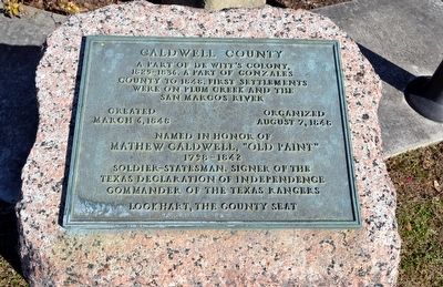
A part of De Witt’s Colony,
1825-1836. A part of Gonzales
County to 1848. First settlements
were on Plum Creek and the
San Marcos River
Created March 6, 1848
Organized August 7, 1848
Named in honor of
Mathew . . . — — Map (db m91552) HM
(side 1)
Born in Rouen France November 22, 1643. Came to Canada in 1668. Founded a first settlement near Montreal. Led several expeditions on the Great Lakes and the Ohio and Illinois rivers. Completed the exploration of the Mississippi, . . . — — Map (db m120700) HM
First called by German immigrants Karlshaven, an important port of Texas. Cargoes of ships were hauled to and from points in Texas and Mexico by carts until 1860 when the San Antonio and Mexico Gulf Railroad and the Indianola Railroad were completed . . . — — Map (db m120706) HM
An Early Landing Place of
Supplies for the Interior
Captain Jack Shackelford's
"Red Rovers" of Alabama
Disembarked at This Point
A Town Established Here in 1836
Was Burned by Indians in 1840 — — Map (db m181121) HM
In Whose Honor Jefferson County, Texas
Was Named Chief Justice of Calhoun County
1848-1856 Born in Kentucky
March 12, 1801 Died July 25, 1865 — — Map (db m237452) HM
First official county seat of Callahan County, 1877 - 1883. The first unofficial county seat was Callahan City where the commissioners court was organized, July 30, 1877, and several civil and probate cases filed. By an invalid election, October . . . — — Map (db m79092) HM
Formed from Bexar Territory
Created February 1, 1858
Recreated August 21, 1876
Organized July 3, 1877
Named in Honor of
James H. Callahan, 1812-1856
Soldier in the Texas Revolution
Captain of the Texas Rangers
County . . . — — Map (db m80805) HM
Founder of Brownsville and partner in firm of M. Kenedy and Company, which opened the Rio Grande to steamboat navigation and controlled much of the commerce of Northern Mexico, 1848-1868.
This house, erected about 1850,
was the birthplace of . . . — — Map (db m117849) HM
Created February 12, 1848
From Nueces County
Organized August 7, 1848
Named in Honor of Ewen Cameron 1811-1843 Captain in the Mier Expedition Shot at Queretaro County Seat, Santa Rita 1848-1849 Brownsville, Since the Earliest Battles of . . . — — Map (db m220711) HM
Created February 12, 1848
Since 1535 men of all nations of the earth sailed
the blue waters of the Gulf of Mexico to the green
valley of the Rio Grande in search of happiness,
and each found it in his own time and in his own way. . . . — — Map (db m118636) HM
Oldest permanent fort in Texas called Fort Taylor in March, 1846 Later renamed in honor of Major Jacob Brown killed here in May, 1846 Permanent post established, 1849 Evacuated by Federal troops in 1861; by Confederates, 1863 Reoccupied by . . . — — Map (db m222837) HM
At this site the last battle of the Civil War, known as Palmito Hill, was fought by Confederate troops under Colonel John S. (Rip) Ford and Union Forces on May 13, 1865, 34 days after Lee's surrender at Appomattox. — — Map (db m118442) HM
These palmetto piling are the remains of the Boca Chica Crossing of the railroad from Boca Chica Inlet to White's Ranch on the Rio Grande. Begun by General Francis H. Herron, U.S.A., in 1864 and completed in 1865 by General Philip H. Sheridan for . . . — — Map (db m164594) HM
The beacon for the commerce of the Rio Grande
Erected by the United States Government in 1852
Extinguished during the Civil War
Discontinued, 1888 - 1895
Permanently discontinued, 1905
Erected by the State of Texas . . . — — Map (db m156329) HM
The spot where "American blood was shed on American soil" April 25, 1846 Here Captain Philip Thornton and 62 dragoons were attacked by Mexican troops. — — Map (db m164598) HM
Formed from Young and Bexar territories; created August 21, 1876, organized June 29, 1888. Named in honor of Samuel P. Carson 1798-1840, statesman of the United States and the Republic of Texas. Wheat, oil and gas contribute to its wealth. . . . — — Map (db m149695) HM
Formed from Bowie County land. Created April 25, 1846; organized July 13, 1846.
Named in honor of Gen. Lewis Cass (1782-1866). United States soldier and statesman, a strong advocate of annexation of Texas. Important river port city of . . . — — Map (db m159846) HM
Formed from Jefferson and Liberty counties.
Created February 12, 1858. Organized August 2, 1858.
Named in honor of General Thomas Jefferson Chambers
1802-1865
The first and only superior judge of Texas before the Revolution. Member of . . . — — Map (db m121264) HM
On this site first known as Perry's Point, a fort, established in 1830 by General Manuel Mier y Terán for the purpose of halting Anglo-American colonization was named Anahuac, the Aztec name of Mexico City, then the capital of Texas. The . . . — — Map (db m117183) HM
Surveyor General of Texas, 1829. Sole superior judge of Texas before 1836. Active in the cause of independence. Member of Secession Convention, 1861. Chambersea, later Anahuac, and a Texas county were named in his honor. — — Map (db m121340) HM
Built before 1835 as a home and trading post by Martin Lacy, Indian agent for the Mexican government.
Used as a place of refuge after the massacre of the Killough family, October 5, 1838. — — Map (db m121259) HM
Originally established as Mission San Francisco de los Tejas in 1690 by Franciscan missionaries for the purpose of Christianizing and civilizing the Neches and other Indians of the region. Reestablished in 1716. Abandoned temporarily due to French . . . — — Map (db m121257) HM
Here at the opening of the 18th century stood a village of the Neches Indians. Their name was given to the river and later to a mission, San Francisco de Los Neches, established near by. With the Cherokees, the Neches Indians were expelled from . . . — — Map (db m121335) HM
Noted as interpreters and messengers of peace, the Delawares were chiefly instrumental in bringing other tribes to the General Treaty at Bird's Fort (in the present county of Tarrant) in 1843. — — Map (db m121258) HM
Birthplace of James Stephen Hogg, son of Lucanda McMath Hogg and Joseph Lewis Hogg. Born March 24, 1851. Died March 3, 1906. First native Texan to serve as governor. Inspirer of the passage of the Railroad Commission Law, Stock and Bond Law, Alien . . . — — Map (db m40474) HM
Named in honor of Joseph T. Cook • Native of North Carolina • Early settler in Nacogdoches • Owner of land on which a military company under Captain Black built a fort never attacked by Indians • On adjacent land, James Cook built a store and . . . — — Map (db m237454) HM
Formed from Young and Bexar
Territories
Created • Organized
August 21, 1876 • April 11, 1887
Named in honor of
George Campbell Childress
1804 – 1841
A member of the Convention
in 1836
Co-author of the Texas . . . — — Map (db m96825) HM
Formed from Cooke County
Created December 24, 1857
Organized August 6, 1860
Disorganized in 1862
because of Indian raids
Reorganized August 4, 1873
Henrietta, headquarters for
buffalo hunters until 1878
The first Hereford . . . — — Map (db m96691) HM
Created August 21, 1876, from Bexar County. Named for a native of New Jersey, Robert Cochran, a private who died for Texas Independence in the siege of the Alamo.
Indian hostilities and the distance to market and supplies made settlement slow. . . . — — Map (db m76252) HM
Established by the United States Army, October 28, 1852, as a protection to frontier settlers against Indians. Named in honor of
Lieutenant T.L. Chadbourne,killed at Resaca de la Palma, May 9, 1846. Occupied by Federal troops, 1852-1859; . . . — — Map (db m77861) HM
One mile southeast to Fort Chadbourne, a station on the Butterfield Mail and Stage Line, which linked St. Louis and San Francisco, 1858-1861. The fort was established in 1852, occupied until its surrender to State forces in 1861, and garrisoned at . . . — — Map (db m143124) HM
Formed from Tom Green County
Created March 13, 1889
Organized April 23, 1889
Named in Honor of
Richard Coke
1829 - 1896
Governor of Texas 1874-1876
Member of United States Senate
1878 - 1896
County Seat, . . . — — Map (db m82995) HM
Formed from Travis and Brown
counties. Created February 1,
1858, Organized October 6, 1864.
Named in honor of
Robert M. Coleman
1799-1837
A signer of the Declaration
of Independence
A hero of San Jacinto,
Organizer of . . . — — Map (db m91740) HM
Originally established on the Colorado River by the United States Army as a protection for the frontier against hostile Indians
Moved in August, 1856, to this site
Abandoned by Federal troops February 26, 1861
The site became . . . — — Map (db m94553) HM
In early Texas had Apache, Comanche, Kiowa camps and mountain lookouts. White settlement began at Camp Colorado, U.S. 2nd Cavalry post on Jim Ned Creek, 1857. County was created Feb. 1, 1858. Named for Robert M. Coleman (1799-1837), a signer of . . . — — Map (db m94526) HM
Formed from Fannin County Created April 3, 1846 Organized July 13, 1846 Named in honor of Collin McKinney 1766-1861 Land surveyor Signer of the Texas Declaration of Independence Member of Congress, Republic of Texas Member of the Texas . . . — — Map (db m171047) HM
Formed from Young and Bexar
Territories
Created • Organized
August 21, 1876 • November 4, 1890
Named in Honor of
James Collinsworth
1806-1838
The first Chief Justice of the
Republic of Texas. Signer of the
Declaration of . . . — — Map (db m100235) HM
Oldest permanent settlement and
once largest town in Colorado
County. Established by the pioneer
Alley family (William, John, Rawson,
Thomas and Abraham), all members
of Austin's original 300 settlers.
Terminus of the Buffalo Bayou, . . . — — Map (db m143994) HM
Site of the camp,
March 19-26, 1836
of the Texas Army
under General Sam Houston,
who directed the retreat
from Gonzales to the San Jacinto — — Map (db m76821) HM
A part of Stephen F. Austin's
First Colony
Created March 17, 1836
Organized in 1837
The river traversing the region was called “Colorado” (red) by Spanish explorers who mistook it for the reddish Brazos. From the river, the . . . — — Map (db m71994) HM
Site of projected capitol of
Stephen F. Austin's colony, 1823.
First settlement at this point shown on
Stephen F. Austin's map of 1835 as Montezuma.
The municipality of Colorado was created by the
provisional government of Texas . . . — — Map (db m130393) HM
Site of the Camp, March 20-26, 1836, of one division of General Santa Anna's Army under the command of General Joaquín Ramírez y Sesma. It crossed the Colorado at Atascosita Ford, eight miles below Columbus. — — Map (db m29707) HM
First German settlement in Colorado County • Founded in 1837 by William Frels who immigrated to Texas in 1834 and fought for independence, 1835-1836 • Proposed site of Hermann University, first institution of higher learning sponsored by . . . — — Map (db m237458) HM
Formed from Travis and Bexar
land districts
Created March 24,1846
Organized July 13, 1846
Named for the river
so called from the pancake shape
of the islands formed by its springs
New Braunfels, county seat
established March . . . — — Map (db m130112) HM
Soldier in the Texas Revolution · Father of Texas botany · Editor of the New Braunfelser Zeitung, 1852-1872 Erected by the State of Texas 1936 Additional marker New Braunfels German Heritage Center of Texas recognizes this property Site of . . . — — Map (db m156494) HM
Founded on March 21, 1845 by Carl, Prince of Solms-Braunfels, Commissioner-General of the Society for the Protection of German Immigrants in Texas. Named after Prince Solms' estate, Braunfels, on the Lahn River in Germany. Its permanence was assured . . . — — Map (db m117665) HM
Established in 1850 by John F. Torrey 1821••1893
Pioneer promoter of Texas industry • He operated a flour, grist and saw mill, a sash, door and blind factory (1850), a cotton factory (1863) and the first woolen factory in Texas • with . . . — — Map (db m210383) HM
First settled in 1854 by five families, the county, created and organized 1856, was named for Comanche Indians, Lords of Texas frontier, who were losing hunting grounds to settlers.
First county seat was Cora. Comanche has been county seat . . . — — Map (db m98274) HM
Created February 1, 1858
Organized March 11, 1879.
Named for the river which the Spaniards called the Concho because of the many shells that they found in it.
Paint Rock, The County Seat — — Map (db m30087) HM
Gainesville was a station on the Southern Overland Mail Line (Butterfield Route), which provided semi-weekly mail and stage service between St. Louis and San Francisco, 1858-1861. The line was 2795 miles long – one of the longest stage . . . — — Map (db m96750) HM
Created March 20, 1848. Organized March 10, 1849.
Named in honor of
William G. Cooke
1808-1847
Captain of the "New Orleans Greys," 1835
Assistant Inspector General
at San Jacinto, 1836
Member of the Santa Fe Expedition, 1841 . . . — — Map (db m121775) HM
Formed from Bell County
Created February 4, 1854
Organized March 4, 1854
Named in Honor of
James Coryell
Born in Tennessee in 1796
Member of the Bowie Expedition
tο the old San Saba Silver
Mines in 1831
A Texas . . . — — Map (db m217503) HM
Formed from Tom Green County Created February 26, 1887 Organized September 3, 1927. Named in honor of William Carey Crane 1816-1885. A Baptist minister President of Baylor University 1863-1885 Crane, The County Seat. — — Map (db m85569) HM
Established in 1855 by the United States Government as a protection to travelers and mail on the overland route from San Antonio to San Diego. Abandoned in 1861. Reoccupied in 1868 for a short time. — — Map (db m126687) HM
Formed from
Young and Bexar Territories
Created • Organized
August 21, 1876 • September 20, 1986
Named in honor of
Stephen Crosby
1800-1869
came to Texas in 1845
Commissioner of the General Land
Office
County seat, . . . — — Map (db m105191) HM
In memory of Henry Clay Smith, 'Uncle Hank'...Born in Germany, August 15, 1836, died, May 20, 1912 and Elizabeth Boyle Smith, 'Aunt Hank,'...Born July 12, 1848, died, June 5, 1925....Pioneers of the Plains, builders of the Rock House, 1877, a . . . — — Map (db m246409) HM
A town founded in 1879 by a colony of English Quakers under the leadership of Isaac Paris Cox who purchased for them 82 sections of land. The town, first named Marietta in honor of Mary Cox, wife of the leader, was renamed Estacado in 1886 when . . . — — Map (db m106238) HM
Built in 1858 as a station on the Butterfield overland mail route St. Louis to San Francisco · Abandoned in 1859, when the line was shifted to the Davis Mountain route. — — Map (db m116734) HM
This is a two-sided marker
(Front): Native Georgian. Came to Texas 1856. Although opposed to secession he aided in raising 18th Texas Infantry as Lt. Colonel, C.S.A. Made commanding Colonel of 18th in 1862. After service in Vicksburg area . . . — — Map (db m44613) HM
Formed from El Paso County; Created March 10, 1911; Organized April 18, 1911; Named for David B. Culberson 1830-1903 famous constitutional lawyer, a Confederate officer, member of the Texas legislature, member of the United States congress; Van . . . — — Map (db m43479) HM
Formed from Young and Bexar
territories
Created Organized
August 21, 1876 July 28, 1891
Named in honor of James W. Dallam
1818-1847
Compiler of digest of decisions
of Supreme Court of the
Republic of Texas, 1845 . . . — — Map (db m88747) HM
The unincorporated town of Dallas was designated as a postoffice by the Republic of Texas in 1843. The County of Dallas was created by the first Legislature of Texas on March 30, 1846 from portions of Robertson and Nacogdoches counties. Both city . . . — — Map (db m158020) HM
Visited in 1840 by Colonel Wm. G. Cooke's preliminary exploration for a route between Austin and Red River. A community also called Cedar Springs, established in this vicinity in 1843 by Dr. John Cole, rivalled Dallas in an election in 1848 for . . . — — Map (db m148843) HM
Site of the First Agency, January, 1845, of the Texian Land and Emigration Company. Generally known as "Peters' Colony" in honor of William S. Peters who, under a colonization contract secured in 1841 from the Republic of Texas, introduced more . . . — — Map (db m148647) HM
Established by Joseph H. Sherrard, William L. Killem, Pleasant Taylor and John M. Crockett in 1862 to manufacture pistols for the State of Texas. — — Map (db m152507) HM
Created February 1, 1858
Recreated August 21, 1876
from Bexar Territory
Organized February 13, 1905
Named in honor of
Nicholas Mosby Dawson
1808-1842
Who fought at the Battle of
San Jacinto and fell at
Dawson's . . . — — Map (db m110193) HM
Formed from Young and Bexar
Territories
Created August 21, 1876
Organized October 3, 1890
Named in honor of
Erastus “Deaf” Smith
1787-1837
Came to Texas in 1821
Rendered valuable service as a scout and
spy during . . . — — Map (db m56022) HM
Formed from Lamar and Hopkins
Counties
Created July 29, 1870
Organized October 6, 1870
The name describes its position
and triangular shape
Cooper, the county seat — — Map (db m119291) HM
Created April 11, 1846
from Fannin County
Organized July 13, 1846
with Denton as county seat
Both town and county are
named in honor of
John B. Denton
1807-1841
Pioneer preacher, lawyer
and Indian fighter
First county seat . . . — — Map (db m121786) HM
Born in Tennessee July 26, 1806, came to Texas in January, 1836, as a Methodist circuit rider. Killed in the Village Creek Indian fight May 24, 1841 in what is now Tarrant County. Named for Gen. Edward H. Tarrant who commanded the volunteers. Denton . . . — — Map (db m121788) HM
De Witt County
Included in the colonial grant in 1825 to Green De Witt, Texas empesario ▲ Settled until 1840 largely by Anglo Americans ▲ Created a county of the state of Texas March 24, 1846, its area being taken from Gonzales, . . . — — Map (db m195686) HM
Created March 24, 1846
from Gonzales, Victoria
and Goliad counties;
Organized July 13, 1846,
with Cuero as the county seat
Named in honor of
Green De Witt
A Texas Empresario
Born in Kentucky September 16, 1797
Died in . . . — — Map (db m131927) HM
Privates Gregg, William Max, W. H. Kilpatrick and other soldiers who met death in this region while serving under General R. S. MacKenzie, Fourth U.S. Cavalry, 1871-1872 and 1874-1875. With no hope of honor if victorious; no dream of mercy if they . . . — — Map (db m104773) HM WM
Here behind extensive breastworks Major Thomas M. Anderson, Tenth U.S. Infantry, maintained a supply camp for the Cavalry under General Ranald S. Mackenzie, Fourth U.S. Cavalry, who in 1874-1875 forced the Indians of the region onto reservations and . . . — — Map (db m104771) HM
In this first cemetery of Donley County, sixteen rods west lie the first dead of Old Clarendon. Here white civilization sank its roots in sadness and from the graves in this sacred acre strong pioneer spirits turned to face the future with greater . . . — — Map (db m151697) HM
Formed from Young and Bexar
territories
Created • Organized
August 21, 1876 • March 22, 1882
Named in honor of
Stockton P. Donley
1821 – 1871
a Confederate officer
elected to the Texas Supreme
Bench in 1866 . . . — — Map (db m96829) HM
The J.H. McCleskey No. 1 Discovery Well of the Ranger Pool was drilled by Warren Wagner under the supervision of W.K. Gordon of the Texas Pacific Coal and Oil Company, July 2 - October 17, 1917. Initial production was three million feet of gas. . . . — — Map (db m98133) HM
Created February 26, 1887
from Tom Green County
Organized January 15, 1891
Named in honor of
Matthew Duncan Ector
1822-1879
Member of the Texas Legislature
A Confederate Officer and
outstanding jurist
Odessa, The County . . . — — Map (db m86704) HM
The regal highway extending between his Catholic majesty's far flung kingdoms of New Spain, from Mexico City to the Kingdom of New Mexico, passed here. From 1581 onward it was the route followed by conqueror, padre, merchant, adventurer and settler. . . . — — Map (db m239454) HM
On May 4, 1598, Don Juan de Oñate, Adelantado and Capitain-General, Governor of New Mexico, first named El Paso del Rio del Norte.
Through this old pass, the lowest snow-free feasible route from the Atlantic to the Pacific through the Rocky . . . — — Map (db m24743) HM
Approximate site of
the Mission and Pueblo of
San Antonio
de Senecú
Established by Don Antonio de Otermín and Father Fray Francisco Ayeta. O.F.M. in 1682 - Maintained by Franciscan missionaries for the civilizing and Christianizing of the . . . — — Map (db m37951) HM
This block was the site of the stage station of the Southern Overland Mail line which connected St. Louis and San Francisco with a semi-weekly stage and mail service, 1858-1861. — — Map (db m60719) HM
Resentment over private control of the salt lakes in the region, often called Guadalupe Lakes, in 1877 led to the El Paso Salt War which entailed the loss of many lives and much property. — — Map (db m118294) HM
814 entries matched your criteria. Entries 101 through 200 are listed above. ⊲ Previous 100 — Next 100 ⊳