776 entries match your criteria. The first 100 are listed. ⊳
Virginia Civil War Trails Historical Markers
By J. J. Prats, May 11, 2008
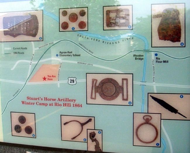
Closeup of Map and Photos of Artifacts on Marker
| 1 ► Virginia, Albemarle County, Charlottesville, Woodbrook — Rio Hill — Artifacts Found at Rio Hill — |
| Near Woodbrook Drive west of Seminole Trail (U.S. 29). | |||
| 2 ► Virginia, Albemarle County, Charlottesville, Woodbrook — Rio Hill 1864 Skirmish — George A. Custer Attacks a Confederate Winter Camp — |
| Near Woodbrook Drive west of Seminole Trail (U.S. 29). | |||
| 3 ► Virginia, Albemarle County, Scottsville — Scottsville — When War Came — |
| On East Main Street (Virginia Route 6) just east of Valley Street (Virginia Route 20), on the right when traveling east. | |||
| 4 ► Virginia, Alexandria, Seminary Hill — Fort Ward — 1861-1865 — |
| Near West Braddock Road, on the right when traveling west. | |||
| 5 ► Virginia, Alexandria, Taylor Run — Alexandria — Alexandria in the Civil War |
| On Callahan Drive at King Street (Virginia Route 7), on the right when traveling north on Callahan Drive. Reported permanently removed. | |||
| 6 ► Virginia, Alexandria, Taylor Run — Alexandria in the Civil War — "Alexandria is ours!" — |
| Near Callahan Drive at King Street (Virginia Route 7), on the right when traveling north. | |||
| 7 ► Virginia, Alleghany County, Covington — Averell’s Salem Raid — Narrow Escape at Island Ford Bridge — |
| On Mall Road, 0.2 miles east of Horse Mountain View (Virginia Route 648), on the left when traveling east. | |||
| 8 ► Virginia, Alleghany County, Longdale Furnace — Australia Furnace — Alleghany Iron for the Confederacy — |
| On Longdale Furnace Road (Virginia Route 269) at Collierstown Road (Virginia Route 770), on the right when traveling west on Longdale Furnace Road. | |||
| 9 ► Virginia, Alleghany County, Longdale Furnace — Lucy Selina Furnace — Alleghany Iron for the Confederacy — |
| On Longdale Furnace Road (Virginia Route 269) at Collierstown Road (Virginia Route 770), on the right when traveling west on Longdale Furnace Road. | |||
| 10 ► Virginia, Alleghany County, Low Moor — Jackson River Depot — Crook's Raid — |
| On Selma Low Moor Road (Virginia Route 696) 0.2 miles west of Oakland Drive, on the right when traveling west. | |||
| 11 ► Virginia, Amelia County, Amelia Court House — Amelia Court House — Fatal Delay — Lee's Retreat — |
| On Virginia Street at Court Street (Virginia Route 38/1007), on the right when traveling north on Virginia Street. | |||
| 12 ► Virginia, Amelia County, Deatonville — Deatonville — "Continuous shifting battle" — Lee's Retreat — |
| On East Sayler's Creek Road (Virginia Route 617) west of South Genito Road (Virginia Route 616), on the right when traveling west. | |||
| 13 ► Virginia, Amelia County, Jetersville — Amelia Springs — Two Days of Action — Lee's Retreat — |
| On Amelia Springs Road (Virginia Route 642) 0.2 miles south of St. James Road, on the right when traveling north. | |||
| 14 ► Virginia, Amelia County, Jetersville — Hillsman House — Lee’s Retreat — April 6, 1865 — |
| Near Saylers Creek Road (Virginia Route 617), on the left when traveling south. | |||
| 15 ► Virginia, Amelia County, Jetersville — Holt's Corner — Lee's Army Divides — Lee's Retreat — |
| On Sayler's Creek Road (Virginia Route 617) at James Town Road (Virginia Route 618), on the left when traveling west on Sayler's Creek Road. | |||
| 16 ► Virginia, Amelia County, Jetersville — Overton / Hillsman House — War's Horror Knocks at the Door — |
| On Saylers Creek Road (County Route 617) 1 mile south of James Town Road (County Route 618), on the right when traveling east. | |||
| 17 ► Virginia, Amelia County, Mannboro — Namozine Church — Pursuit Cathces Up — Lee’s Retreat — |
| On Mill Quarter Road (County Route 622) at Namozine Road (Route 708), on the left when traveling north on Mill Quarter Road. | |||
| 18 ► Virginia, Appomattox County, Appomattox — Battle of Appomattox Station — Final Blow — Lee's Retreat — |
| On Main Street (Virginia Route 131), on the right. | |||
| 19 ► Virginia, Appomattox County, Appomattox — Confederate Artillery Position — Battle of Appomattox Station — |
| Near Jamerson Lane (Virginia Route 1014) at Jones Street (Route 1012). | |||
| 20 ► Virginia, Appomattox County, Appomattox — Custer's Third Brigade — Battle of Appomattox Station — |
| Near Jamerson Lane (Virginia Route 1014) at Jones Street (Virginia Route 1012). | |||
| 21 ► Virginia, Appomattox County, Appomattox — Robertson House Fight — Last Casualties at Appomattox — Lee's Retreat — |
| Near Oakville Road (Virginia Route 26) north of Richmond Highway (U.S. 460), on the right when traveling south. | |||
| 22 ► Virginia, Appomattox County, Appomattox — Robertson House Fight — Last Cavalry Clash at Appomattox — Lee's Retreat — |
| Near Oakville Road (Virginia Route 26) north of Richmond Highway (U.S. 460), on the right when traveling south. | |||
| 23 ► Virginia, Appomattox County, Appomattox — Walker's Last Stand — Custer's Charges — |
| Near Jamerson Lane (Virginia Route 1014) at Jones Street (Virginia Route 1012). | |||
| 24 ► Virginia, Appomattox County, Vera — Lee’s Rear Guard — Final Blow — Lee’s Retreat — |
| On Howe Flood Highway (State Highway 24), on the left when traveling south. | |||
| 25 ► Virginia, Arlington County, Arlington, Arlington Mill — Early Engagement — "A Skirmish at Arlington Mills" — |
| On Columbia Pike (Virginia Route 244) east of South Dinwiddie STreet, on the left when traveling east. | |||
| 26 ► Virginia, Arlington County, Arlington, Foxcroft Heights — Freedman’s Village — A New Home for African Americans — |
| On South Oak Street at Southgate Road, on the right when traveling north on South Oak Street. | |||
| 27 ► Virginia, Arlington County, Arlington, Old Glebe — Fort Ethan Allen — Mr. Lincoln’s Forts — Defenses of Washington - 1861-1865 |
| On Old Glebe Road, on the right when traveling north. Reported permanently removed. | |||
| 28 ► Virginia, Arlington County, Arlington, Old Glebe — Fort Ethan Allen — Mr. Lincoln's Forts — Defenses of Washington, 1861 - 1865 — |
| Near North Old Glebe Road south of North Stafford Street, on the right when traveling north. | |||
| 29 ► Virginia, Arlington County, Arlington, Woodmont — Fort C.F. Smith — Defending the Capital |
| Near 24th Street North. Reported permanently removed. | |||
| 30 ► Virginia, Arlington County, Arlington, Woodmont — Fort C.F. Smith — Mr. Lincoln’s Forts — Defenses of Washington, 1861-1865 |
| Near 24th Street North. Reported permanently removed. | |||
| 31 ► Virginia, Arlington County, Arlington, Woodmont — Fort C.F. Smith — Protecting the Capital |
| Near 24th Street North. Reported permanently removed. | |||
| 32 ► Virginia, Arlington County, Arlington, Woodmont — Fort C.F. Smith — Defending the Capital — Defenses of Washington, 1863-1865 — |
| Near 24th Street North, 0.1 miles east of 23rd Road North, on the left when traveling east. | |||
| 33 ► Virginia, Arlington County, Arlington, Woodmont — Fort C.F. Smith — Protecting the Capital — Defenses of Washington, 1863-1865 — |
| On 24th Street North, 0.1 miles west of 23rd Road North, on the right when traveling west. | |||
| 34 ► Virginia, Arlington County, Arlington, Woodmont — Fort C.F. Smith — Mr. Lincoln's Forts — Defenses of Washington, 1863-1865 — |
| On 24th Street North, 0.1 miles west of 23rd Road North, on the right when traveling west. | |||
| 35 ► Virginia, Augusta County, New Hope — Battle of Piedmont — Final Action at New Hope — |
| On Battlefield Road (County Route 608), on the left when traveling south. | |||
| 36 ► Virginia, Augusta County, Swoope — West View — Confederate Camps — 1862 Valley Campaign — |
| On Parkersburg Turnpike (Route 254), on the right when traveling west. | |||
| 37 ► Virginia, Augusta County, West Augusta — Mountain House — Jackson's March — 1862 Valley Campaign — |
| On Shenandoah Mountain Drive (U.S. 250) at Ramsey's Draft North, on the right when traveling west on Shenandoah Mountain Drive. | |||
| 38 ► Virginia, Bedford County, Bedford — Avenel — In the Eye of the Storm — Hunter’s Raid — |
| Near Avenel Avenue north of Burwell Way, on the right when traveling south. | |||
| 39 ► Virginia, Bedford County, Bedford — Bedford — Hunter’s Raid — 1864 Valley Campaign — |
| On South Bridge Street at West Main Street (U.S. 221), on the left when traveling north on South Bridge Street. | |||
| 40 ► Virginia, Bedford County, Bedford — Peaks of Otter — “A rougher road could not be imagined” — Hunter’s Raid — |
| On Blue Ridge Parkway near Peaks Road (Virginia Route 43). | |||
| 41 ► Virginia, Bedford County, Forest — New London Academy — Confederate Cavalry Line — Hunter’s Raid — |
| On East Lynchburg Salem Turnpike (U.S. 460) at Thomas Jefferson Road (Virginia Route 811), on the right when traveling west on East Lynchburg Salem Turnpike. | |||
| 42 ► Virginia, Botetourt County, Buchanan — Buchanan Bridge — An Artillery Duel Ensued — Hunter’s Raid — |
| Near Lowe Street (County Road T-1305) west of Main Street (U.S. 11), on the right when traveling west. | |||
| 43 ► Virginia, Botetourt County, Buchanan — The Anchorage — Unexpected Guests — Hunter's Raid — |
| On Main Street (U.S. 11) at 15th Street (County Road T-1313), on the right when traveling south on Main Street. | |||
| 44 ► Virginia, Botetourt County, Buchanan — Wilson Warehouse — “Fit only for … owls and bats.” — Hunter’s Raid — |
| On Lowe Street (County Road T-1305) at Washington Street, on the right when traveling south on Lowe Street. | |||
| 45 ► Virginia, Brunswick County, Alberta — Danieltown — A Side Raid: 32 Troopers Captured — Wilson-Kautz Raid — |
| On Christanna Highway (Virginia Route 46) at New Hope Road, on the right when traveling north on Christanna Highway. | |||
| 46 ► Virginia, Brunswick County, Dolphin — Smoky Ordinary — “Rebel cavalry” — Wilson-Kautz Raid — |
| On Liberty Road at Old Stage Road, on the left when traveling east on Liberty Road. | |||
| 47 ► Virginia, Brunswick County, Lawrenceville — Brunswick County Courthouse — |
| On North Main Street (Business U.S. 58) south of Bank Street, on the left when traveling south. | |||
| 48 ► Virginia, Caroline County, Bowling Green — Star Hotel — Conspirator's Lair — |
| On North Main Street (State Highway 2) at Courthouse Lane (Local Route 1204), on the right when traveling north on North Main Street. | |||
| 49 ► Virginia, Caroline County, Guinea — Guinea Station — Grant Maneuvers South — Lee vs. Grant – The 1864 Campaign — |
| Near Stonewall Jackson Road (Virginia Route 606) near Guinea Station Road (Virginia Route 634). | |||
| 50 ► Virginia, Caroline County, Milford — Milford Station — Lee Avoids A Trap — Lee vs. Grant – The 1864 Campaign — |
| On Colonial Road at Antioch Road, on the right when traveling south on Colonial Road. | |||
| 51 ► Virginia, Caroline County, Port Royal — Port Royal — Union Supply Depot — |
| On King Street north of Water Street, on the right when traveling north. | |||
| 52 ► Virginia, Caroline County, Ruther Glen — Carmel Church — Gathering for North Anna — Lee vs. Grant - The 1864 Campaign — |
| On Jericho Road (Virginia Route 207) at Jefferson Davis Highway (U.S. 1), on the left when traveling south on Jericho Road. | |||
| 53 ► Virginia, Caroline County, Woodford — Bethel Church — Union Command Meets — Lee vs. Grant - The 1864 Campaign — |
| On South River Road, on the right when traveling south. | |||
| 54 ► Virginia, Charles City County, Charles City — Piney Grove — The Front Line and the Home Front — |
| Near The Glebe Lane near Southall Plantation Lane. | |||
| 55 ► Virginia, Charles City County, Charles City — Stuart's Ride — Safe among Friends and Family — 1862 Peninsula Campaign — |
| On Adkins Road (Virginia Route 618) at Church Lane, on the right when traveling south on Adkins Road. | |||
| 56 ► Virginia, Charles City County, Charles City — Stuart's Ride — Coffee at Rowland’s — 1862 Peninsula Campaign — |
| Near John Tyler Memorial Highway (Virginia Route 5) 0.2 miles east of Herring Creek Road (Virginia Route 640), on the right when traveling east. | |||
| 57 ► Virginia, Charles City County, Charles City — Westover — McClellan’s New Base — 1862 Peninsula Campaign — |
| Near Westover Road (Virginia Route 633) 2.1 miles east of Harrison Landing Road. | |||
| 58 ► Virginia, Charles City County, Charles City — Wilcox’s Landing — Crossing the James — Lee vs. Grant – The 1864 Campaign — |
| On Wilcox Wharf Road, 0.2 miles south of Dalmation Drive, on the left when traveling south. | |||
| 59 ► Virginia, Charlotte County, Charlotte Court House — Charlotte Court House — Foraging Parties: “People complimented us” — Wilson-Kautz Raid — |
| On David Bruce Avenue (Virginia Route 40) at Legrande Avenue (Virginia Route 47), on the right when traveling east on David Bruce Avenue. | |||
| 60 ► Virginia, Charlotte County, Drakes Branch — Drakes Branch — "Burnt all the depot buildings" — Wilson-Kautz Raid — |
| On Depot Street at Drakes Main Street (Virginia Route 47), on the right when traveling south on Depot Street. | |||
| 61 ► Virginia, Charlotte County, Keysville — Keysville — Foraging and Destruction — Wilson-Kautz Raid — |
| On King Street (Virginia Route 40) at J Street, on the left when traveling east on King Street. | |||
| 62 ► Virginia, Charlotte County, Randolph — Wilson-Kautz Raid — “Destroy both those roads” — |
| On River Road (County Route 607) at Mulberry Hill Road (County Route 641), on the right when traveling west on River Road. | |||
| 63 ► Virginia, Charlotte County, Saxe — Carrington's Mill — "The D_ _ _ Rebels" — Wilson-Kautz Raid — |
| Near Hailey Road (County Route 759) at Sylvan Hill Road (County Route 612). | |||
| 64 ► Virginia, Charlotte County, Wylliesburg — Wylliesburgh — First Rest — Wilson-Kautz Raid — |
| On Jackson-Vaughan Road (County Route 607) at Moody Circle Road, on the left when traveling west on Jackson-Vaughan Road. | |||
| 65 ► Virginia, Charlottesville, North Downtown — Charlottesville — Confederate Heroes Remembered |
| On West Market Street at First Street, on the right when traveling west on West Market Street. Reported permanently removed. | |||
| 66 ► Virginia, Chesapeake, Deep Creek North — Village of Deep Creek — The Dismal Swamp Rangers |
| Near Luray Street. Reported permanently removed. | |||
| 67 ► Virginia, Chesapeake, Deep Creek North — Village of Deep Creek — "The den of the Rebels" — |
| On Luray Street, 0.3 miles north of George Washington Highway North (Business U.S. 17), on the right when traveling north. | |||
| 68 ► Virginia, Chesapeake, Greenbrier West — Village of Great Bridge — A Vital Link |
| On Locks Road, 0.3 miles west of North Battlefield Boulevard (Virginia Route 168), on the left when traveling west. Reported permanently removed. | |||
| 69 ► Virginia, Chesapeake, Greenbrier West — Village of Great Bridge — A Vital Link — |
| On Locks Road, 0.3 miles west of North Battlefield Boulevard (Virginia Route 168), on the left when traveling west. | |||
| 70 ► Virginia, Chesapeake, Pleasant Grove East — The Cuffeytown Thirteen — Patriot Heroes — |
| On Long Ridge Road at Cuffee Road, on the left when traveling north on Long Ridge Road. | |||
| 71 ► Virginia, Chesapeake, Pleasant Grove West — Dismal Swamp Canal — The Battle of South Mills — |
| Near Douglas Road (Old U.S. 17) at George Washington Highway (Old U.S. 17), on the right when traveling south. | |||
| 72 ► Virginia, Chesapeake, Pleasant Grove West — Glencoe — "He was brave, gentle and polished" — |
| On South George Washington Highway (U.S. 17), on the left when traveling north. | |||
| 73 ► Virginia, Chesapeake, Pleasant Grove West — Pleasant Grove Baptist Church Cemetery — Home of the Jackson Greys — |
| On St. Brides Road, 0.3 miles south of Benefit Road, on the left when traveling south. | |||
| 74 ► Virginia, Chesapeake, Pleasant Grove West — Seven Patriot Heroes — Homes and Last Resting Places — |
| Near Relay Road at Ballahack Road, on the left when traveling south. | |||
| 75 ► Virginia, Chesterfield County, Chester — Battery Dantzler — Dueled with Union Gunboats — |
| On Battery Dantzler Road, 0.2 miles east of Old Stage Road, on the left when traveling east. | |||
| 76 ► Virginia, Chesterfield County, Chester — Battle of Chester Station — May 10, 1864 |
| On West Hundred Road (Virginia Route 10) east of Parker Lane, on the right when traveling east. Reported missing. | |||
| 77 ► Virginia, Chesterfield County, Chester — Bermuda Hundred Landing — Butler’s Campaign Begins — Bermuda Hundred Campaign — |
| On Bermuda Hundred Road, 1.4 miles east of Allied Road, on the right when traveling east. | |||
| 78 ► Virginia, Chesterfield County, Chester — Dutch Gap Canal — Butler's Bypass — Bermuda Hundred Campaign — |
| Near Henricus Park Road, 1.3 miles east of Coxendale Road (County Route 615). | |||
| 79 ► Virginia, Chesterfield County, Chester — Half-Way House — Butler’s Headquarters — Bermuda Hundred Campaign — |
| On Jefferson Davis Highway (U.S. 1) at Wonderview Drive, on the right when traveling north on Jefferson Davis Highway. | |||
| 80 ► Virginia, Chesterfield County, Chester — Sgt. James Engle — Medal of Honor Recipient — Bermuda Hundred — |
| On Tobacco Bay Place south of Greyledge Boulevard, on the left when traveling south. | |||
| 81 ► Virginia, Chesterfield County, Chester — USCTs At Dutch Gap — U.S. Colored Troops Construct the Canal — Bermuda Hundred — |
| Near Henricus Park Road, 1.3 miles east of Coxendale Road. | |||
| 82 ► Virginia, Chesterfield County, Chesterfield — Chesterfield Court House — Soldiers and Refugees — Lee’s Retreat — |
| Near Iron Bridge Road (Virginia Route 10) at Wagners Way. | |||
| 83 ► Virginia, Chesterfield County, Enon — Point of Rocks — U.S. Military Hospital Site — Bermuda Hundred — |
| Near Enon Church Road (Virginia Route 746) at Ramblewood Drive, on the left when traveling west. | |||
| 84 ► Virginia, Chesterfield County, Pickadat Corner — Battle of Swift Creek — "Brave to Madness" — |
| On Jefferson Davis Highway (U.S. 1 / 301), on the right when traveling north. | |||
| 85 ► Virginia, Chesterfield County, Richmond — Fort Stevens — Butler’s Campaign Ends — Bermuda Hundred Campaign — |
| On Pams Avenue at Norcliff Avenue, on the left when traveling north on Pams Avenue. | |||
| 86 ► Virginia, Clarke County, Arcadia Farm — Battle of Cool Spring — Sharp Action at the Shenandoah River — 1864 Valley Campaign — |
| On Castleman Road (Virginia Route 603) at Harry Byrd Highway (Virginia Route 7), on the right when traveling east on Castleman Road. | |||
| 87 ► Virginia, Clarke County, Longwood — Battle of Cool Spring — Sharp Action at the Shenandoah River — Early's 1864 Attack on Washington — |
| On Parker Lane, on the right when traveling north. | |||
| 88 ► Virginia, Clarke County, Longwood — Battle of Cool Spring — Union Advance and Confederate Counterattack — Early's 1864 Attack on Washington |
| Near Parker Lane, on the left when traveling north. Reported missing. | |||
| 89 ► Virginia, Clarke County, Longwood — Col. George D. Wells Leads the Way — Battle of Cool Spring — Early's 1864 Attack on Washington — |
| Near Parker Lane south of Alder Lane, on the right when traveling south. | |||
| 90 ► Virginia, Clarke County, Longwood — Confederate Counterattack and Union Retreat — Battle of Cool Spring — Early's 1864 Attack on Washington — |
| Near Parker Lane at Alder Lane, on the right when traveling south. | |||
| 91 ► Virginia, Clarke County, Longwood — Thoburn’s Rescue — Battle of Cool Spring — Early’s 1864 Attack on Washington — |
| Near Parker Lane at Alder Lane, on the left when traveling north. | |||
| 92 ► Virginia, Colonial Heights — Dunlop Station — "…burning cartridges like shooting stars" |
| On Old Town Drive at East Ellerslie Drive, on the right when traveling south on Old Town Drive. Reported unreadable. | |||
| 93 ► Virginia, Colonial Heights — Ellerslie — Beauregard’s Headquarters — |
| On Longhorn Drive, 0.1 miles north of Ellerslie Avenue, on the left when traveling north. | |||
| 94 ► Virginia, Colonial Heights — Fort Clifton — Guardian of the Appomattox — |
| On Brockwell Lane, 0.3 miles east of Conduit Road, in the median. | |||
| 95 ► Virginia, Colonial Heights — Fort Clifton — A stronghold that was never taken — |
| Near Brockwell Lane, 0.3 miles east of Conduit Road. | |||
| 96 ► Virginia, Colonial Heights — Lee at Violet Bank — Siege Headquarters |
| Near Virginia Avenue at Arlington Avenue. Reported permanently removed. | |||
| 97 ► Virginia, Colonial Heights — Lee at Violet Bank — Siege Headquarters — |
| On Virginia Avenue at Arlington Avenue, on the right when traveling north on Virginia Avenue. | |||
| 98 ► Virginia, Culpeper County, Brandy Station — Battle of Brandy Station — The Largest Cavalry Battle of the Civil War — |
| On Beverly Ford Road (County Route 677) at St. James Church Road (County Route 676) on Beverly Ford Road. | |||
| 99 ► Virginia, Culpeper County, Brandy Station — Battle of Brandy Station — Headquarters Hill — |
| On Fleetwood Heights Road (Virginia Route 685) near Stuart Lane, on the right when traveling east. | |||
| 100 ► Virginia, Culpeper County, Brandy Station — Battle of Brandy Station — Battle for Fleetwood Hill — |
| On Fleetwood Heights Road (Virginia Route 685) at Stuart Lane, on the right when traveling east on Fleetwood Heights Road. | |||
776 entries matched your criteria. The first 100 are listed above. Next 100 ⊳