In early 1890, the Burlington Railroad established Siding 7 three-quarters of a mile up the tracks north from here. The siding consisted of four short, fan-shaped tracks and a hand-operated turntable over an open pit used for servicing engines. . . . — — Map (db m119899) HM
According to tradition, American Indians were stricken with an epidemic known as “fell disease” about the middle of the 16th century that threatened to obliterate the tribes. A messenger arrived from the Great West with news of a . . . — — Map (db m124081) HM
Tribal tradition states that as long ago as the 16th century the Fall River Valley and canyon area were seldom without groups of tipis belonging to North American Plains Tribes. They knew the curative value of the warm springs located there and used . . . — — Map (db m184455) HM
John S. Robertson (1866-1937) was a pioneer in farming and fruit growing in the Black Hills. His dryland orchard was located about four miles north, at an elevation of 4,200 feet. Born in Ohio in 1866, Robertson homesteaded in Fall River County in . . . — — Map (db m184459) HM
This highway along Fall River is dedicated to Leslie Jensen, 15th Governor of South Dakota 1937-1939, a native of Hot Springs, and a son of Chris Jensen, Black Hills Pioneer and Lillie May Haxby Jensen. Educated in Hot Springs, Culver Military . . . — — Map (db m184428) HM
This highway along Fall River is dedicated to Leslie Jensen, 15th Governor of South Dakota 1937-1939, a native of Hot Springs, and a son of Chris Jensen, Black Hills Pioneer and Lillie May Haxby Jensen. Educated in Hot Springs, Culver Military . . . — — Map (db m184450) HM
Gigantic Mammoths, ancestors of the elephants of today, once roamed freely across the High Plains of North America. A repository of their remains, along with other prehistoric animals, lay undisturbed until their discovery over 26,000 years later, . . . — — Map (db m184458) HM
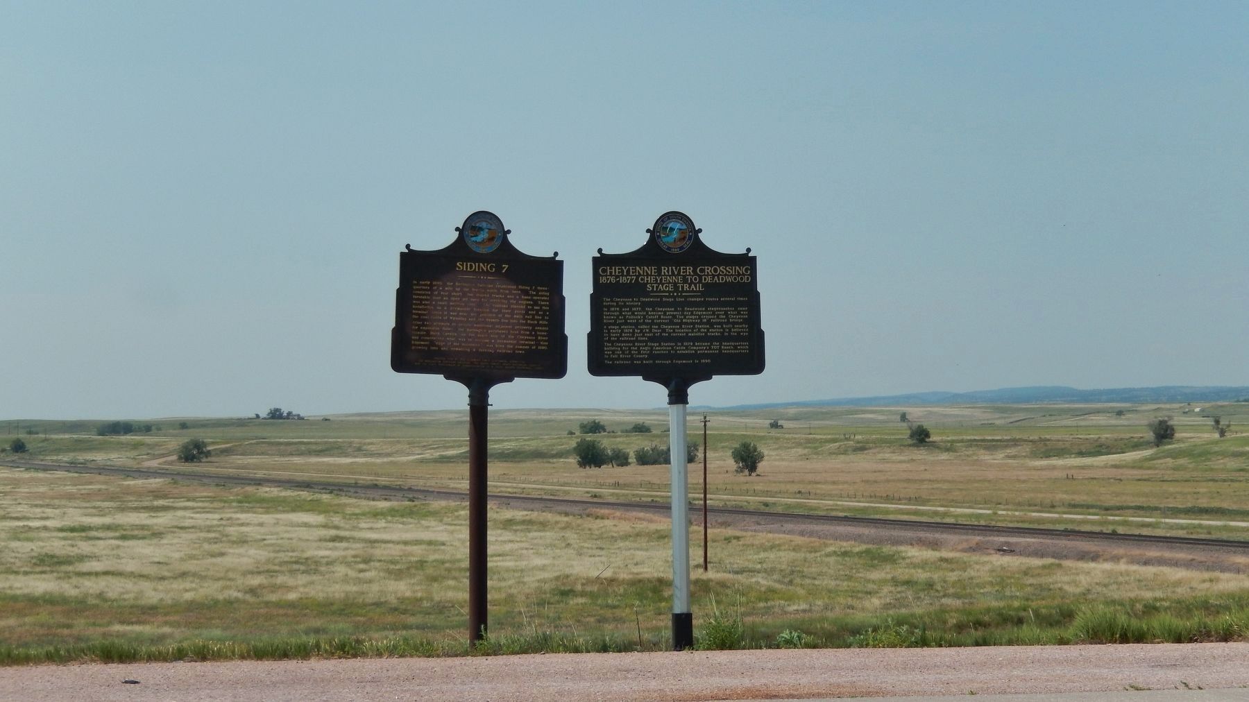
Approximately 125 yards east of this spot the Wood Stage Station served as a stop on the Sydney to Deadwood Trail. This station offered the first glimpse of the Black Hills to travelers seeking their fortune in the newly opened gold fields. The . . . — — Map (db m184456) HM
Born Oct. 23, 1858 on a farm near Volney, Iowa. Homesteaded in McCook County, South Dakota in 1879. Moved to Faulk County in 1883 where he married Emma Beaver in 1888. The following year the first of five sons was born. Gov. Byrne was elected to the . . . — — Map (db m179950) HM
First county seat of Faulk County, when this area surveyed October 1882 by Albert Mellen, Louis Kniesel just south and F.M. McMullen, a mile west, were "squatting" on the land. First post office, Cecrops, Nora Reppy, postmistress, was . . . — — Map (db m179952) HM
In this city, on July 17, 1925, by action of the South Dakota Department of the American Legion, the nation-wide organization of Legion Junior Baseball was first proposed as a program of service to the youth of America. — — Map (db m197681) HM
In 1877 some Sisseton Christian Indians sponsored by the Presbyterian Mission, with Daniel Renville as native pastor, decided to take homesteads near Yellowbank Creek north of this point. That year they erected their church, the first in Grant . . . — — Map (db m197527) HM
The town was named for H.E. Bonesteel, early day freighter. Its first postmaster was Francis M. Safeser, 1 August 1892. By 1905 it had 754 people and had made the Big Time Headlines. It came about his way. In 1902 the railroad reached Bonesteel . . . — — Map (db m234830) HM
1893 Die Bethlehem Duetsche Congregational Gerininde Later Bethlehem German Congregational or Stone Church. This was the first deed registered in organized Gregory County. Church grounds were donated by John Hoffman April 8, 1897.
This pioneer . . . — — Map (db m234934) HM
was established by Brig. Gen. W. S. Harney in 1856 and named by him for Col. Daniel Randall, Deputy Paymaster U.S. Army. Construction was started on June 26, 1856 by 1st Lts. George H. Paige, 2nd Inf. and D.S. Stanley, 1st Cavalry, Col. E. Lee 2nd . . . — — Map (db m188367) HM
provided in further explanation of the plane orientation table to the right rear.
Legend
A - Comdg. Off. Qtrs.
B - Officers Qtrs.
C - Barracks
D - Hospital
E - Guard House
F - Magazine
G - Commissary & Store
H - . . . — — Map (db m187793) HM
(side 1)
In 1889 South Dakota was admitted to the union and western
South Dakota was opened for settlement. The next year surveying was conducted throughout the summer and the town of Midland, named for its location halfway between the . . . — — Map (db m124087) HM
Harlan J. Bushfield, born August 6, 1882 in Atlantic, Iowa, came to Miller in 1883. He earned his law degree from the University of Minnesota in 1904 and returned to Miller to practice law. In 1912, Bushfield married Vera Cahalan, a fellow Miller . . . — — Map (db m185466) HM
Ree Heights Roadside Park
The railroad beat the settlers into this area where farms are giving way to cattle ranches, now as it was then. Ree Heights first postmaster was Wm. H. Love 8 June 1882. Three miles South are the Ree Heights, . . . — — Map (db m185461) HM
The town of Epiphany came into being between the years 1889-1892 and was named by Bishop Martin Marty. In 1893 Father William Kroeger a Catholic priest and medical doctor established the town of “Kroeger”. He built his own laboratory where he made . . . — — Map (db m179876) HM
U.S. Highway 85 Regina, Canada – El Paso, Texas 1588 miles through five states South Belle Fourche • 78 Deadwood • 103 North State Line • 80 Williston, N.D. • 219 Probably the first white men to traverse this area were Wilson Price Hunt and his . . . — — Map (db m231200) HM
Following the disastrous battles of the Rosebud and Little Big Horn
(Custer) in Montana in June, 1876, the Sioux, save Gall and Sitting
Bull with 400 lodges who went to Canada and Crazy Horse and his
band, in the main, started to drift back to . . . — — Map (db m183413) HM WM
Historically that meridian is significant. For two generations the Insurance Companies and other world-wide lending agencies would not, as a matter of agreed policy, lend a shiny dime west of this line. There reason was that some geographer had . . . — — Map (db m123868) HM
On the Bluff, a quarter of a mile North, ancient Indians, pre-dating the Aricara, built a fortress or strong point, involving an exterior perimeter of over 2,000 yards, enclosing about 50 acres, and with bastions, at intervals all along its . . . — — Map (db m220068) HM
Camp S-207 (SE-207 in 1933): ¼ mile W and 2 miles S on Farm Island Companies: Number unknown -- (Blacks) 06/27/33 - 10/22/33; 796 -- (North Dakotans) 10/23/33 - 11/01/34; 2756 -- 10/20/34 - 09/30/37.
The Civilian Conservation Corps was a . . . — — Map (db m220042) HM
Coe Isaac Crawford was born on January 14, 1858 on a farm near Volney, IA. Growing up, he worked nine months out of the year and attended school only in the winter months. At age 15 he left home to attend school fulltime in the neighboring town of . . . — — Map (db m220039) HM
The first and only hanging in Hughes County was April 18, 1885 when James H. Bell, who killed Forest G. Small with a hatchet on Dec. 4th, 1884, was hanged to a ladder leaned against the county flag pole here after a mob took him from the county jail . . . — — Map (db m124279) HM
Hughes County Courthouse (marker side 1)
The Hughes County Courthouse was built and occupied in February 1935, to replace the original 1883 brick structure. The new Courthouse was designed by architects Hugill and Blatherwick of Sioux . . . — — Map (db m124269) HM
Born in Canada, John Sutherland taught school in Wisconsin and received his law degree from Brown University. He came to Dakota Territory in 1884. The young Scottish attorney led Pierre’s campaign committee to resounding victories in the . . . — — Map (db m124080) HM
On this, then private, pasture dotted with Sioux Effigies (see marker north 1 mile), Colonel Charles Lindbergh landed his Ryan monoplane, "The Spirit of Saint Louis", September 1st 1927 at exactly 4 pm. On May 21st he had been the first person to . . . — — Map (db m176674) HM
On September 22, 1804 Lewis & Clark passed by this river and camped a couple of miles up the Missouri. They called it Reuben River for Reuben Fields, one of their hunters. In 1839 however this was called Medicine Knoll River by Nicollet & Fremont, . . . — — Map (db m220071) HM
Stephen Return Riggs became a Missionary to the Sioux in Minnesota in 1837. Thomas L. Riggs was born in 1847 and twenty-five years later was delegated to serve the Teton Sioux on the Missouri. His first Station, Hope, was west of the Missouri, . . . — — Map (db m178666) HM
Pierre Was a Cowtown (marker side 1)
Yes sir, Mister, Pierre was a cowtown. Why they built the sidewalks two feet off the ground to keep the cows from spattering ‘em up. The stockyards ran longside the river for half a mile and three . . . — — Map (db m124153) HM
An Aricara lookout surprised by a Sioux War party and badly wounded, took flight to warn his kinsmen. He ran about one-half mile and keeled over dead. The Sioux, admiring his bravery, placed a rock for each drop of his blood and a cairn where he . . . — — Map (db m177386) HM
In the field 400 yards south is a monument to and vestiges of the site of Fort Sully. After General Alfred Sully's troops had fought the Battle of Whitestone Hill near Ellendale, North Dakota, against the Indians in the fall of 1863, they marched . . . — — Map (db m220040) HM
This huge structure and its lake, 200 miles long, will cover a multitude of Historic Sites. Oahe is a Dacotah (Sioux) Indian word meaning "Something to stand upon," a foundation, and so it was that in 1875 Thomas L. Riggs, Congregational . . . — — Map (db m112897) HM
The partnership of Registre Loisel and Hugh Heney in 1802 set up a fur post on Cedar Island, within sight, about 5 miles down stream. Loisel was called Little Beaver by the Indians. This was part of Louisiana, receded by Spain to France in 1800 and . . . — — Map (db m219925) HM
This marker commemorates the immigration of the first large groups of Swiss, Low German and Hutterian Brethren from Russia to Dakota Territory.
The first group of fifteen families arrived in Yankton on October 17, 1873. However a . . . — — Map (db m182291) HM
Highmore, so named as highest point on Northwestern between Chicago and Missouri River, was called Siding No. 5, until Peter O. Swalen was appointed postmaster 7 June 1882, soon after the first surveyors found him and 31 other squatters holding down . . . — — Map (db m185462) HM
Tom Berry was the first of three Governors elected from West of the Missouri River since statehood in 1889.
Berry with his wife, Lorena McLain, (1879-1963), are buried in the family plot in the Belvidere Cemetery ½ mile north of this marker. . . . — — Map (db m184634) HM
Camps NP-2: 8 miles S of Wall on SD 240, 13 miles W (1 mile W of Sage Creek); and NP-3: 3/4 mile S. of Cedar Pass Visitor Center. Company: 2754 (NP-2) -- 11/1/39 - 10/24/41; (NP-3) -- 10/24/41 - 3/25/42. The Civilian Conservation Corps was a . . . — — Map (db m45287) HM
Cleveland T. Hall is credited by records of historical societies and of the U.S. Department of the Army with carrying the message which saved our nation's capital at the only time it has been seriously threatened by an invasion of enemy forces. . . . — — Map (db m180766) HM
This marks a camp-site of Dakota's first highway 1857, known as Noble's Trail, from Ft. Ridgley, Minn., to the Missouri River.
Also marks the site of Levi Hain's log cabin, erected 1876. — — Map (db m180749) HM
Robert S. Vessey was born near Oshkosh, Wisconsin, May 16, 1858. His father was a minister-farmer with a family of 15 children. He attended common school, but dropped out at an early age to work and assist in the support of his father’s family. He . . . — — Map (db m180805) HM
Wood and water were essential to pioneer road builders and in 1857, when the Fort Ridgely & South Pass Wagon Road was built by Col. W.H. Nobles, the springs at Wessington Hills was a natural on the Reconnaissance to the Missouri River. On the . . . — — Map (db m180808) HM
Mighty few towns have one of them hi-faluting, swank Rolls-Royce type of hyphenated names. In 1904, Murdo Mackenzie, head of the Matador brand, with herds from Mexico to Canada, shipped trainload after trainload of Texas steers to Evarts to graze on . . . — — Map (db m134517) HM
Reading Brands
Two old cowpokes reading twenty brands wont agree on all of them but generally speaking this is how to read a brand.
A letter like this (image of backwards letter F) is a reverse F. But this (image of letter F leaning . . . — — Map (db m134569) HM
Home of roving Indians until 1862. The exploring party of Nicollet, scientist, and Fremont, ‘Pathfinder of the West,’ visited Oakwood Lakes July 1838, leaving the first reliable record.
The region East of the Big Sioux was ceded by the Santee . . . — — Map (db m179692) HM
A region of buffaloes and Indians until 1870s. Indian mounds are found at Spirit Lake. In 1838 the Nicollett-Fremont party skirted the NE corner. In 1857 Inkapaduta’s renegade Indians passed through with two white women captives, victims of the . . . — — Map (db m179691) HM
This is the homestead site of Charles and Caroline Ingalls
and their daughters Mary, Laura, Carrie and Grace
In four of her Little House series of stories of pioneering by the Ingalls and Wilder families, Laura Ingalls Wilder, . . . — — Map (db m209488) HM
De Smet Forest Half mile South East of De Smet
De Smet Forest was established by the South Dakota Fish, Game and Parks Department in 1946 and is one of hundreds of small roadside parks now existent or planned along South Dakota highways. At . . . — — Map (db m123917) HM
As a lasting tribute to the memory of Father Pierre Jean De Smet of the Society of Jesus, who for over thirty years offered his life in the service of the Indian people traveling far beyond the Rocky Mountains and sharing with them his deep love of . . . — — Map (db m182757) HM
Beginning in 1883, worship in homes of German immigrant settlers
Organized July 13, 1895
Founding Pastor J. Hansen
Pioneer Members
August Albrecht
Carl Albrecht
Ferdinand L. Albrecht
William Albrecht
Herman Eick
Karl . . . — — Map (db m182754) HM
Organized as Emmanuel in 1882
Reorganized as St. Paul
April 17, 1898
Located on present church site
O. I. Satre, Founding Pastor
Charter Members
O. I. Satre
Karel Dahl
B. Christopherson
C. Bergerson
P. A. Ranklev . . . — — Map (db m182752) HM
Originally Lake Thompson Ev. Lutheran
Organized March 30, 1882
6½ miles S.E. of DeSmet
O. I. Satre, Founding Pastor
Charter Members
John Ekse · Knudt Simonson
Ove Johnson · Ole Berqvan
O. S. Sorsdal · Iver Amundson
Iver . . . — — Map (db m182749) HM
On the low hill immediately west of this spot stood the homestead claim shanty of Almanzo and Laura Ingalls Wilder. Mrs. Wilder (1867-1957) is known all over the world as the author of the "Little House" books, a series of autobiographical accounts . . . — — Map (db m182759) HM
Born March 8, 1884, in homestead shanty 3 miles S. ½ mile E. to Thomas and Bersha Dunn, was one of three children. From rural school he entered State College, Brookings, in 1901 to study art under Ada B. Caldwell, of whom he wrote: "She took a . . . — — Map (db m179939) HM
Dakota Territory was created in 1861 and got its first big impetus in 1874 when gold was confirmed in the Black Hills by General Custer. A hundred years later on August 27, 1961, a gold rush was created by Joe Floyd’s KELO-LAND TV and Radio . . . — — Map (db m182765) HM
You are about to enter
Kingsbury County
A region of buffaloes and Indians until 1870s. Indian mounds are found at Spirit Lake. In 1838 the Nicollet-Fremont party skirted the NE corner. In 1857 Inkepaduta's renegade Indians passed through . . . — — Map (db m179687) HM
Charles B. Kennedy arrived at this location in March 1878. He said, upon his arrival, "There is not a tree in sight, nor sign of human habitation, only paths made by Indians and Buffalo leading to a flowing spring near by." This spring led to his . . . — — Map (db m237341) HM
Lake Herman was the original stopping point on the Indian Trail that led from the pipestone quarries in Minnesota to the Three Rivers of the Sioux, a Sioux sanctuary near Fort Thompson on the Missouri. State Highway No. 34 closely follows this . . . — — Map (db m180136) HM
Lake County was started October, 1873 when Herman N. Luce and John T. Hare, the first qualified County Commissioners, met at the cabin of William Lee near the site of old Madison, to organize. William Van Eps platted the old town of Madison June . . . — — Map (db m177441) HM
Soldier Statesman
Educator Conservationist
Through his leadership twenty million acres of school lands were saved for posterity in South Dakota, North Dakota, Montana, Idaho, Wyoming and Washington.
President of this school 1889 - . . . — — Map (db m177759) HM
In 1877 a group of Swiss chose a point on the shore of Lake Badus for a colony. In 1878 Joseph Burkler, his family and some single men, arrived. In 1879 the colony was augmented by 11 other families who came by rail to Luverne, Minnesota and thence . . . — — Map (db m179686) HM
Lake County So named because of its beautiful lakes. It had been the realm of the Dacotah (Sioux) Indians with few white intruders until ceded by the Yankton tribe in 1858. In 1857 the Noble's Trail was built across its NE corner and that year . . . — — Map (db m177453) HM
Camp F-6 (Roubaix): 100 yards N of Lake entrance: W of road. Companies: 792--6/3/33-5/15/35: 10/18/35 6/1/40; 10/1/40-10/11/41; 2759V-(Detachment from Park Creek)--5/15/35-10/18/35.
The Civilian Conservation Corps was a federal work-relief . . . — — Map (db m185223) HM
Near this point in 1875 occurred the first of two initial gold discoveries in the Deadwood area. The more accepted account of the
discovery states that in late August; 1875 a party consisting of Frank
Bryant, John B. Pearson, Thomas Moore, Richard . . . — — Map (db m185224) HM
"Deadwood's Sky Pilot." Henry Weston Smith, was born in Ellington, Connecticut, January 110, 1828. At 23 he became a Methodist exhorter. This led to ordination in the Methodist Episcopal church and he served various communities in New England. In . . . — — Map (db m184295) HM
Near this point in 1875 occurred the second of two initial gold discoveries in the Deadwood area. It was made by the Lardner party of eight prospectors, steered here by John B. Pearson, a man already familiar with Deadwood Gulch. Their "Discovery . . . — — Map (db m185225) HM
Camp F-3 (Este): Located 1/2 mile west astride Estes Creek.
Companies: 789 - - 5/18 - 7/30/41
2759V - - (WWI Vets) 7/30/41 - 7/28/42
The Civilian Conservation Corps was a federal relief program during 1933-1942 that gave jobless men . . . — — Map (db m184412) HM
South Dakota's rich western heritage has been remembered along the inter-state highway system at safety rest areas and tourist information centers.
The eight pillars which thrust skyward here merge in the framework of a tipi, the Plains . . . — — Map (db m202618) HM
Frontcame to these hills in 1833 seven of us
De Lacompt
Ezra Kind
G W Wood
T Brown
R Kent
Wm King
Indian Crow
all ded but me Ezra Kind
Killed by Ind beyond the high hill got our gold June 1834
got all of the . . . — — Map (db m184176) HM
In 1940, fourteen South Dakota chapters of the Daughters of the
American Revolution (DAR) contributed funds for the planting of
18.000 Ponderosa "Penny Pines" in a 25 acre tract along the west
side of Highway 85, about 4 1/2 miles from Deadwood . . . — — Map (db m184013) HM
Cattle began arriving in the 1860s when the cattle drives came up from the south bringing the large herds of long horned cattle, and in the 1870s homesteaders brought small herds to the Whitewood area. The natural tall prairie grass of the High . . . — — Map (db m184172) HM
In November of 1887, the Fremont, Elkhorn and Missouri Valley Railroad pulled into Whitewood. These passenger and freight trains were the first to reach the Northern Black Hills from the East. Whitewood remained the end of the line for three years . . . — — Map (db m184290) HM
Augustana was founded as Augustana Seminary in Chicago in 1860 by the Scandinavian Evangelical Lutheran Augustana Synod. The school's purpose was "to educate young men for the holy ministry in the Lutheran church . . . (and) to prepare men for the . . . — — Map (db m183483) HM
Augustana was founded as Augustana Seminary in Chicago in 1860 by the Scandinavian Evangelical Lutheran Augustana Synod. The school's purpose was "to educate young men for the holy ministry in the Lutheran church . . . (and) to prepare men for the . . . — — Map (db m183585) HM
First appeared on maps as Commerce City 1866. Its first postmaster was Benjamin Hill, appointed 14 May 1868. First settler here, L.P. Hyde, 1861. Cuppett, Hewit, & Rea built a blockhouse spring 1868 where Court House now stands. County organized 30 . . . — — Map (db m177394) HM
Receiving Congressional appropriations in 1899, the Hiawatha Asylum for Insane Indians was the second federal mental hospital and the first dedicated to American Indians. The first patient arrived in 1902, and through 1934, more than 370 . . . — — Map (db m183486) HM
In 1915, Elizabeth Harney, who trained as a practical nurse, built this hospital with the backing of Dr. Samuel Young. Elizabeth opened the hospital in 1916 and employed doctors Young, Volin, and Stevens. The Harney family lived in the upper . . . — — Map (db m227327) HM
In 1886 the Cedar Rapids, Iowa Falls & Northwestern Railroad built a railway line from Larchwood, Iowa, through Springdale Township, Lincoln County, to Sioux Falls, Dakota Territory. The Springdale Station depot was established here; later it became . . . — — Map (db m183589) HM
Iona established 11 Feb. 1898, Ray Gooder, Postmaster. Here E. L. Senn, newspaper crusader fought the cattle rustlers and lost his newspaper by fire in early days. — — Map (db m184644) HM
On Sept. 17, 1804, Lewis and Clark camped on the west bank below the Island and passing it on the 18th said: "Passed an Island about the middle of the river at 1 mile this island is about a mile long and has a great proportion of Red cedar on . . . — — Map (db m179941) HM
Wal partner, in 1862 when the Civil War was being fit and Dakota Territory took in everything South of Canada to the Rocky Mountains, the legislature gave a ferry license across the Old Muddy down at Yankton to J.S. Presho. Come 1872 they were . . . — — Map (db m177439) HM
White River has been so called since Perrin de Lac camped near mouth and met Cheyennes in 1802. 16 Sept. 1804 Sgt. Patrick Gass and Reuben Fields reconnoitering were at this point. — — Map (db m184643) HM
Camp SCS-2 (DPE-22 in 1934): in city park at SW corner of Presho. Companies: 2756—8/1/34-10/20/34; 758—5/29/35-10/25/35; 2737—4/3-/36-10/15/36; 4726—5/15/38-10-15-38; 2770 detachment from Huron—late 1935 and early 1936.
The Civilian . . . — — Map (db m184640) HM
Flowing just north of here, Medicine Creek runs through the center of Lyman County, emptying into the Missouri River 27 miles (43 kilometers) to the northeast. The place-names of this Central South Dakota area read like an index to early state . . . — — Map (db m184639) HM
Frank Leroy Farrar was born in Britton on April 2, 1929, son of third-generation Marshall County homesteaders. He was an Eagle Scout and Boys State governor and graduated from Britton High School. Farrar then earned business and law degrees from the . . . — — Map (db m197801) HM
Major John Clowney, 30th Wisconsin Infantry with Cos. B. E. G. and K, Captains Burton, Devlin, Swain & Klatt, started the fort on 1 August 1864, pursuant to orders of General John Pope, Department Commander. They were mostly from the north woods and . . . — — Map (db m179954) HM
You are entering
Roberts County
South Dakota
Long the home of Sisseton, Wahpeton & Cuthead Yanktonaise Sioux, it became part of Deuel & Cheyenne Counties in 1862; Deuel extending N to 46th parallel (4 miles N) in 1872. The Reservation . . . — — Map (db m185145) HM
The Milwaukee, building from Marion to the Missouri, in 1880 soon reached Nation, platted in 1879 by Robert and J. B. Nation, with Orlan K. Bullard its postmaster on 5 January 1880 and when changed to Bridgewater on November 20th he continued to . . . — — Map (db m180129) HM
Farmer’s Union Local No. 253 was organized Dec. 15, 1917. Charter Members were J.C. Heinrich, John Noordsy, Henry Preshun, Robert Kaster, Elmer Goodyear, John Reecy, Leo Wingert, Henry Dykstra, Alfred Waechter, John Witkop, and G. H.Kirchner. The . . . — — Map (db m179883) HM
349 entries matched your criteria. Entries 101 through 200 are listed above. ⊲ Previous 100 — Next 100 ⊳