1618 entries match your criteria. Entries 101 through 200 are listed.⊲ Previous 100 — Next 100 ⊳
Historical Markers and War Memorials in South Dakota
By Ruth VanSteenwyk, May 28, 2020
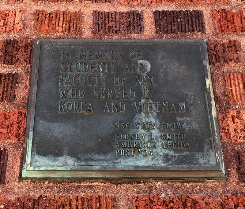
Korea and Vietnam Plaque
| 101 ► South Dakota, Brown County, Aberdeen — Northern State University Veterans Memorial — |
| On 12th Avenue South East at South Jay Street on 12th Avenue South East. | |||
| 102 ► South Dakota, Brown County, Aberdeen — Northern State University World War I Memorial — |
| On 12th Avenue South East at South Jay Street on 12th Avenue South East. | |||
| 103 ► South Dakota, Brown County, Aberdeen — South Dakota Boy's State — Home of — |
| 104 ► South Dakota, Brown County, Aberdeen — Swisher Field — Clark Swisher — |
| Near South Roosevelt Street, 0.1 miles south of Melgaard Rd.. | |||
| 105 ► South Dakota, Brown County, Aberdeen — T. Clarkson Gage Homestead — |
| On 131st Street, 0.5 miles west of 385th Avenue, on the right when traveling west. | |||
| 106 ► South Dakota, Brown County, Aberdeen — The Great Northern Railroad Depot — |
| On Court Street at Railroad Ave. SE, on the right when traveling north on Court Street. | |||
| 107 ► South Dakota, Brown County, Bath — Bath, South Dakota — |
| On State Highway 395, 0.5 miles north of U.S. 12, on the right when traveling north. | |||
| 108 ► South Dakota, Brown County, Columbia — Waterfowl — |
| On Sand Lake Dr., 0.2 miles east of County Highway 16, on the right when traveling east. | |||
| 109 ► South Dakota, Brown County, Columbia — 318 — Columbia — 1879 — |
| Near 396th Avenue. | |||
| 110 ► South Dakota, Brown County, Columbia — Columbia Marsh — |
| On 396th Ave., 0.8 miles 120th St., on the right when traveling north. | |||
| 111 ► South Dakota, Brown County, Columbia — 686 — Daly Corners — |
| On 401st Avenue (County Road 18) at 120th Street (County Road 9), on the right when traveling north on 401st Avenue. | |||
| 112 ► South Dakota, Brown County, Columbia — 570 — Father Alexandra Ravoux — |
| Near 396th Avenue, 0.6 miles south of 115th Street, on the left when traveling south. | |||
| 113 ► South Dakota, Brown County, Columbia — 580 — Hamlin Garland — |
| On Hamlin Garland Highway (123rd Street) (County Road 11) 0.5 miles west of 391st Avenue (County Road 14), on the right when traveling west. | |||
| 114 ► South Dakota, Brown County, Columbia — Sand Lake National Wildlife Refuge — Welcome to — |
| On Sand Lake Dr., 0.2 miles County Highway 16. | |||
| 115 ► South Dakota, Brown County, Columbia — Sand Lake's Observation Tower — …A Bird's Eye View — |
| On Sand Lake Dr, 0.2 miles County Highway 16. | |||
| 116 ► South Dakota, Brown County, Columbia — Songbirds — Neotropical Migrants — |
| On Sand Lake Dr., 0.2 miles County Highway 16, on the right when traveling east. | |||
| 117 ► South Dakota, Brown County, Columbia — The View from the Top — |
| On Sand Lake Dr, 0.2 miles County Highway 16. | |||
| 118 ► South Dakota, Brown County, Frederick — 548 — Aurland — |
| On 391st Avenue (County Road 14) 0.5 miles north of 112th Street (State Highway 10), on the left when traveling north. | |||
| 119 ► South Dakota, Brown County, Frederick — 616 — Colin Campbell Fur Post — |
| Near 382nd Avenue, 0.1 miles north of 111st Street, on the right when traveling north. | |||
| 120 ► South Dakota, Brown County, Frederick — Frederick, South Dakota Veterans Memorial — |
| On Main St at 5th Ave on Main St. | |||
| 121 ► South Dakota, Brown County, Frederick — In Memoriam — |
| Near 101st Street, 0.2 miles west of 392nd Avenue, on the right when traveling west. | |||
| 122 ► South Dakota, Brown County, Frederick — In Memory of the Finnish Pioneers — 1882 — 1955 — |
| On 391st Avenue (County Road 14) at 104th Street (County Road 4), on the right when traveling north on 391st Avenue. | |||
| 123 ► South Dakota, Brown County, Frederick — Old Finnish Apostolic Lutheran Church — National Register of Historic Places — |
| On 392nd Avenue north of 101st Street, on the right when traveling south. | |||
| 124 ► South Dakota, Brown County, Frederick — Philip Cain Gelling Homestead — |
| On 391st Avenue, 0.2 miles north of 111th Street. | |||
| 125 ► South Dakota, Brown County, Frederick — Savo Hall — National Register of Historic Places — |
| On 104th Street (County Road 3) at 391st Avenue (County Road 14), on the left when traveling east on 104th Street. | |||
| 126 ► South Dakota, Brown County, Frederick — 319 — Savo Monument — |
| On 391st Avenue (County Road 14) at 104th Street (County Road 3), on the right when traveling north on 391st Avenue. | |||
| 127 ► South Dakota, Brown County, Frederick — 92-B — South Dakota — You Are Entering — |
| On U.S. 281, 0.2 miles south of 102nd St Southeast, on the right when traveling south. | |||
| 128 ► South Dakota, Brown County, Frederick — The First Frederick School — |
| On 5th Ave. | |||
| 129 ► South Dakota, Brown County, Frederick — Tveit Homestead — |
| On 391st Avenue (County Road 14) 0.7 miles north of 112th Street (State Highway 10), on the right when traveling north. | |||
| 130 ► South Dakota, Brown County, Groton — Groton South Dakota Veteran's Memorial — |
| Near U.S. 37, 0.2 miles north of Highway 12. | |||
| 131 ► South Dakota, Brown County, Houghton — 515 — Civilian Conservation Corps Camp — |
| On 112th Street (State Highway 10) 1.3 miles west of 400th Ave., on the right when traveling east. | |||
| 132 ► South Dakota, Brown County, Houghton — 424 — Ralph Herseth — Twenty-First Governor — |
| On 112th Street (State Highway 10) at 3rd Street, on the right when traveling east on 112th Street. | |||
| 133 ► South Dakota, Brown County, Houghton — Sand Lake National Wildlife Refuge — |
| On County Route 7, 1.3 miles 400th Ave.., on the right when traveling east. | |||
| 134 ► South Dakota, Brown County, Mansfield — John Mansfield — |
| On N. 2nd St., 0.1 miles north of E. Main St., on the left when traveling north. | |||
| 135 ► South Dakota, Brown County, Stratford — Oakwood Post — |
| On Rondell Avenue just east of 2nd Street, on the left when traveling east. | |||
| 136 ► South Dakota, Brown County, Stratford — Stratford Veterans Memorial — |
| On Randell Street, 0.2 miles west of Railway Street, on the right when traveling east. | |||
| 137 ► South Dakota, Brown County, Westport — Madison Gregory — 1848-1885 — |
| On 120th St.. | |||
| 138 ► South Dakota, Brown County, Westport — Pioneers with Unknown Grave sites in Westport Cemetery — Memorial to — |
| On 120th St. | |||
| 139 ► South Dakota, Brule County, Chamberlain — Barger Park — Established 1989 — |
| On West Mott Avenue at North Courtland Street (South Dakota Highway 50), on the right when traveling west on West Mott Avenue. | |||
| 140 ► South Dakota, Brule County, Chamberlain — 169 — Chamberlain — 1880 — |
| On North Main Street (State Highway 50) at Rodeo Avenue, on the left when traveling north on North Main Street. | |||
| 141 ► South Dakota, Brule County, Chamberlain — Dignity — of Earth and Sky — |
| On Interstate 90 at milepost 263. | |||
| 142 ► South Dakota, Brule County, Chamberlain — Divine Infant Home — 1890-1992 — |
| Near Saint Joseph's Drive at Red Cloud Drive, on the right when traveling north. | |||
| 143 ► South Dakota, Brule County, Chamberlain — 582 — Historic Highway — |
| On 344th Avenue, 0.2 miles north of 251st Street, on the left when traveling north. | |||
| 144 ► South Dakota, Brule County, Chamberlain — 456 — Lewis & Clark Memorial Bridge at Chamberlain — |
| Near Interstate 90 at milepost 264. | |||
| 145 ► South Dakota, Brule County, Chamberlain — Lewis and Clark Bicentennial 1804-2004 — |
| Near Interstate 90 at milepost 263. | |||
| 146 ► South Dakota, Brule County, Chamberlain — Missouri River Bridges of South Dakota — National Historic Civil Engineering Landmark — |
| Near Interstate 90 at milepost 263. | |||
| 147 ► South Dakota, Brule County, Chamberlain — Mount Rushmore National Memorial — |
| On I-90 E, on the right when traveling east. | |||
| 148 ► South Dakota, Brule County, Chamberlain — Purple Heart Memorial Highway — |
| Near Interstate 90 at milepost 264. | |||
| 149 ► South Dakota, Brule County, Chamberlain — 114 — Sojourn at Camp Pleasant — Lewis & Clark Expedition — |
| On Interstate 90 at milepost 264. | |||
| 150 ► South Dakota, Brule County, Chamberlain — St. Joseph's Memorial — |
| Near Saint Joseph Drive north of North Main Street (South Dakota Highway 50), on the right when traveling north. | |||
| 151 ► South Dakota, Brule County, Chamberlain — State Capitol - Pierre — |
| On I-90 E, on the right when traveling east. | |||
| 152 ► South Dakota, Brule County, Chamberlain — The Making & Meaning of Dignity — |
| Near U.S. 90 at milepost 263. | |||
| 153 ► South Dakota, Brule County, Chamberlain — World's Only Corn Palace - Mitchell — |
| On I-90 E, on the right when traveling east. | |||
| 154 ► South Dakota, Brule County, Chamberlain, Chamberlain Township — The Missouri River — Chamberlain and the Lewis & Clark Expedition — |
| Near State Highway 50 south of Thunder Road, on the right when traveling south. | |||
| 155 ► South Dakota, Brule County, Chamberlain, Chamberlain Township — The Plant Life — Chamberlain and the Lewis & Clark Expedition — |
| Near State Highway 50 south of Thunder Road, on the right when traveling south. | |||
| 156 ► South Dakota, Buffalo County, Fort Thompson — Spirit of the Circle Monument Stone — |
| On State Highway 47 just north of Lower Road, on the left when traveling north. | |||
| 157 ► South Dakota, Buffalo County, Fort Thompson — The Crow Creek Reservation — |
| On State Highway 47 north of Lower Road, on the right when traveling south. | |||
| 158 ► South Dakota, Buffalo County, Fort Thompson — The Lower Brule Sioux Reservation — |
| On State Highway 47 north of Lower Road, on the right when traveling south. | |||
| 159 ► South Dakota, Buffalo County, Fort Thompson — The Spirit of the Circle Monument — |
| On State Highway 47 north of Lower Road, on the right when traveling south. | |||
| 160 ► South Dakota, Buffalo County, Gann Valley — Center of Population (South Dakota) — |
| Near Osman Ave at Finucane Ave. | |||
| 161 ► South Dakota, Butte County, Belle Fourche — "Buckskin Johnny" Spaulding Cabin — Historic Structure — |
| Near 5th Avenue (CanAm Highway) (U.S. 85) just north of Faulk Street, on the right when traveling north. | |||
| 162 ► South Dakota, Butte County, Belle Fourche — Belle Fourche — "Beautiful Fork" — |
| On State Street (Business U.S. 212) just east of 8th Avenue, on the left when traveling east. | |||
| 163 ► South Dakota, Butte County, Belle Fourche — Butte County Jail — 830-6th Avenue — Historic Structure — |
| Near 6th Avenue just north of Indian Street, on the left when traveling north. | |||
| 164 ► South Dakota, Butte County, Belle Fourche — Butte County War Memorial — |
| Near 5th Avenue (U.S. 85/212) just north of Faulk Street, on the right when traveling north. | |||
| 165 ► South Dakota, Butte County, Belle Fourche — Korean War Memorial — |
| Near 5th Avenue (U.S. 85/212) just north of Faulk Street, on the right when traveling north. | |||
| 166 ► South Dakota, Butte County, Belle Fourche — Lasting Legacy — |
| On 5th Avenue (U.S. 85) at National St. on 5th Avenue. | |||
| 167 ► South Dakota, Butte County, Belle Fourche — Minnesela, So. Dak. — 1882 - 1901 — |
| On Gaver Rd., 1 mile east of Helmer Rd., on the left when traveling east. | |||
| 168 ► South Dakota, Butte County, Belle Fourche — Sheepherder's Monuments — |
| 169 ► South Dakota, Butte County, Belle Fourche — The Great Western Cattle Trail — |
| Near 5th Avenue (U.S. 85/212) just north of Faulk Street, on the right when traveling north. | |||
| 170 ► South Dakota, Butte County, Belle Fourche — Tri-State Area Veterans Memorial — |
| On 5th Avenue (CanAm Highway) (U.S. 85) just north of Indian Street, on the right when traveling north. | |||
| 171 ► South Dakota, Butte County, Belle Fourche — Vietnam War Memorial — 1961-1975 — |
| Near 5th Avenue (U.S. 85/212) just north of Faulk Street, on the right when traveling north. | |||
| 172 ► South Dakota, Butte County, Belle Fourche — Welcome to Belle Fourche — The Geo Center of the U.S. — |
| On 5th Ave (U.S. 85) near Edmunds Street, on the right when traveling north. | |||
| 173 ► South Dakota, Campbell County, Eureka — Hoffnungstal EV. Lutheran Church — |
| On 112th Street (State Highway 10) at 320th Ave, on the right when traveling west on 112th Street. | |||
| 174 ► South Dakota, Campbell County, Herreid — 652 — You are about to enter South Dakota / You are now leaving South Dakota — |
| On U.S. 83 at 102nd St. SE, on the right when traveling south on U.S. 83. | |||
| 175 ► South Dakota, Campbell County, Mound City — Mound City, South Dakota — |
| On 306th Avenue (U.S. 83) 0.3 miles north of 3rd Street, on the left when traveling north. | |||
| 176 ► South Dakota, Campbell County, Pollock — 654 — Flint Store and Post Office — |
| On 296th Ave at State Highway 10, on the right when traveling north on 296th Ave. | |||
| 177 ► South Dakota, Campbell County, Pollock — Lewis and Clark and the Legend of Stone Idol Creek/Lewis and Clark Expedition Meet The Arikara — |
| On State Highway 1804 at 294th Ave, on the right when traveling west on State Highway 1804. | |||
| 178 ► South Dakota, Campbell County, Pollock — Lewis and Clark/Pollock, South Dakota — |
| On State Highway 10 at A Ave, on the left when traveling west on State Highway 10. | |||
| 179 ► South Dakota, Campbell County, Pollock — 662 — Old Pollock / Lot Distribution in New Pollock / Lake Pocasse — |
| On State Highway 1804 at 294th Ave, on the right when traveling west on State Highway 1804. | |||
| 180 ► South Dakota, Campbell County, Pollock — Pollock, South Dakota Settlers / National Bicentennial Wagon Train — |
| On B Avenue (State Highway 1804) at Park Street, on the right when traveling north on B Avenue. | |||
| 181 ► South Dakota, Charles Mix County, Lake Andes — Civilian Conservation Corps Camp — |
| On 382nd Avenue, 0.2 miles south of State Highway 50, on the right when traveling south. | |||
| 182 ► South Dakota, Charles Mix County, Marty — 119 — Martin Marty / Rev. Sylvester Eisenman — |
| On 303rd Street east of 388th Avenue, on the right when traveling east. | |||
| 183 ► South Dakota, Charles Mix County, Marty, Wahehe Township — Treaty of 1858 — Yankton Sioux Tribe — Missouri National Recreational River — |
| On 390th Avenue, 0.2 miles north of County Road 2, on the right when traveling north. | |||
| 184 ► South Dakota, Charles Mix County, Marty, Wahehe Township — 647 — Yankton Sioux Treaty of 1858 Monument — |
| On 390th Avenue, 0.2 miles north of County Road 2, on the right when traveling north. | |||
| 185 ► South Dakota, Charles Mix County, Pickstown — Buffalo Tipi Covers — |
| On U.S. 18, 0.5 miles west of Missouri Drive, on the right when traveling west. | |||
| 186 ► South Dakota, Charles Mix County, Pickstown — Circle of Life — |
| On U.S. 18, 0.5 miles west of Missouri Drive, on the right when traveling west. | |||
| 187 ► South Dakota, Charles Mix County, Pickstown — Fort Randall Dam - Lake Francis Case — |
| On U.S. 18, 0.7 miles west of Lewis Avenue, on the right when traveling west. | |||
| 188 ► South Dakota, Charles Mix County, Pickstown — Gifts of the Buffalo — |
| On U.S. 18, 0.5 miles west of Missouri Drive, on the right when traveling west. | |||
| 189 ► South Dakota, Charles Mix County, Pickstown — Pickstown / Lewis and Clark — Lewis and Clark National Historical Trail — |
| On Lewis Avenue at U.S. 18, on the right when traveling south on Lewis Avenue. | |||
| 190 ► South Dakota, Charles Mix County, Pickstown — Pickstown Centennial Garden Memorial — |
| On Lewis Avenue north of Abnor Drive, on the left when traveling north. | |||
| 191 ► South Dakota, Charles Mix County, Pickstown — Star Power — |
| On U.S. 18, 0.5 miles west of Missouri Drive, on the right when traveling west. | |||
| 192 ► South Dakota, Charles Mix County, Pickstown — Tipi: "They Dwell" — |
| On U.S. 18, 0.5 miles west of Missouri Drive, on the right when traveling west. | |||
| 193 ► South Dakota, Charles Mix County, Pickstown — Women's Work: Making & Raising Tipis — |
| On U.S. 18, 0.5 miles west of Missouri Drive, on the right when traveling west. | |||
| 194 ► South Dakota, Charles Mix County, Pickstown, White Swan Township — A Gathering Place for Eagles — |
| 195 ► South Dakota, Charles Mix County, Pickstown, White Swan Township — Fort Randall Area — |
| 196 ► South Dakota, Charles Mix County, Pickstown, White Swan Township — Fort Randall Eagle Roost — |
| 197 ► South Dakota, Charles Mix County, Pickstown, White Swan Township — Missouri River — |
| 198 ► South Dakota, Charles Mix County, Ravinia — Ravinia School — 1917 – 1967 — |
| On Elm Avenue (County Road 21) 0.1 miles south of 293rd Avenue (U.S. 18), on the left when traveling south. | |||
| 199 ► South Dakota, Charles Mix County, Ravinia — The Ravinia Consolidated School — |
| On 293rd Street (U.S. 18) 0.1 miles west of Elm Avenue (County Road 21), on the right when traveling east. | |||
| 200 ► South Dakota, Charles Mix County, Wagner — Armed Forces Memorial — |
| On Front Avenue Southeast at 1st Street Southeast, on the right when traveling south on Front Avenue Southeast. | |||
1618 entries matched your criteria. Entries 101 through 200 are listed above. ⊲ Previous 100 — Next 100 ⊳