817 entries match your criteria. Entries 101 through 200 are listed.⊲ Previous 100 — Next 100 ⊳
Historical Markers and War Memorials in Vermont
By Jordan Romano
Manchester Vampire Marker
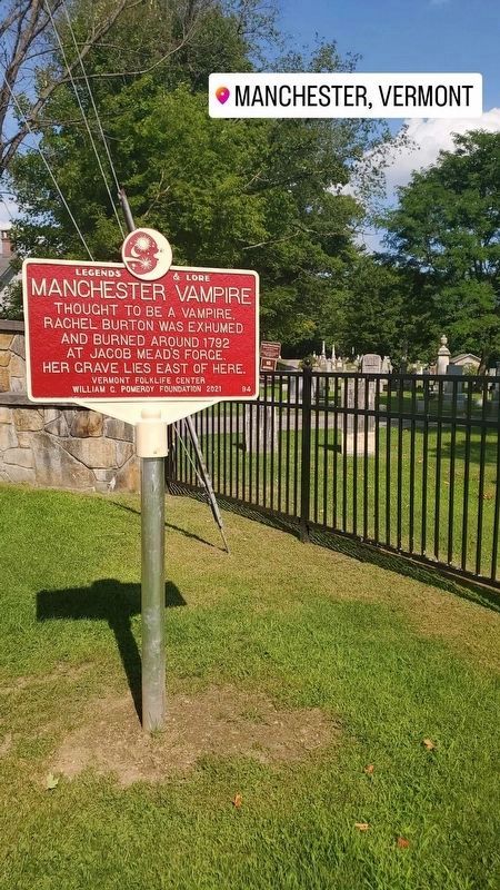
| 101 ► Vermont, Bennington County, Manchester, Manchester Center — 94 — Manchester Vampire — Legends & Lore — |
| On Cemetery Avenue. | |||
| 102 ► Vermont, Bennington County, Manchester, Manchester Center — The Manchester Depot — |
| On Highland Avenue near Elm Street, on the left when traveling north. | |||
| 103 ► Vermont, Bennington County, Manchester, Manchester Center — The Revolutionary War — |
| On Main Street (Alternate Vermont Route 7) at Union Street, on the right when traveling north on Main Street. | |||
| 104 ► Vermont, Bennington County, Manchester, Manchester Center — The Soldiers' Monument — |
| On Main Street (Vermont Route 7A) at Union Street, on the right when traveling north on Main Street. | |||
| 105 ► Vermont, Bennington County, Manchester, Manchester Center — The Southern Vermont Arts Center — |
| On Southern Vermont Art Center Drive, 0.2 miles west of West Road, on the right when traveling west. | |||
| 106 ► Vermont, Bennington County, Manchester Center — Ye Olde Tavern — Vermont Register of Historical Places — |
| On Main Street (Vermont Route 7A) at Palmer Place, on the right when traveling south on Main Street. | |||
| 107 ► Vermont, Bennington County, North Bennington — The Paper Mill Village Bridge — |
| On Murphy Road, 0.1 miles south of N Bennington Road (Vermont Route 67A), on the right when traveling north. | |||
| 108 ► Vermont, Bennington County, North Bennington — House Where Lt .Colonel Baum Died — |
| On U.S. 67 close to Harrington Rd, on the right when traveling east. | |||
| 109 ► Vermont, Bennington County, North Bennington — Hub of History — |
| On River Road at Murphy Road, on the left when traveling west on River Road. | |||
| 110 ► Vermont, Bennington County, North Bennington — McWaters Park — |
| On River Road at Murphy Road, on the left when traveling west on River Road. | |||
| 111 ► Vermont, Bennington County, North Bennington — Paper Mill History / Covered Bridges Span Rivers And Time — |
| On Murphy Road, 0.1 miles south of N Bennington Road (Vermont Route 67A), on the left when traveling north. | |||
| 112 ► Vermont, Bennington County, North Bennington — Railroad Station — North Bennington, Vermont — |
| Near Buckley Road (Vermont Route 67) at Depot Street, on the right when traveling north. | |||
| 113 ► Vermont, Bennington County, North Bennington — Seth Warner House — |
| On Murphy Road at Riverside Drive, on the right when traveling south on Murphy Road. | |||
| 114 ► Vermont, Bennington County, Old Bennington, North Bennington — Birthplace of Vermont — |
| On Murphy Road near Austin Hill Road, on the right when traveling west. | |||
| 115 ► Vermont, Bennington County, Old Bennington, North Bennington — Henry Covered Bridge — across the Walloomsac River — |
| On Murphy Road near Ore Bed Road, on the left when traveling north. | |||
| 116 ► Vermont, Bennington County, Old Bennington — Anthony Haswell — 1756 - 1816 — |
| On Monument Circle. | |||
| 117 ► Vermont, Bennington County, Old Bennington — Before the Battle Monument — |
| On Monument Circle at Monument Avenue on Monument Circle. | |||
| 118 ► Vermont, Bennington County, Old Bennington — Bennington Battle Monument — |
| On Monument Ave. at Main Street (Vermont Route 9), on the left when traveling north on Monument Ave.. | |||
| 119 ► Vermont, Bennington County, Old Bennington — Captain Samuel Robinson — |
| On Monument Avenue at Bank Street, on the right when traveling north on Monument Avenue. | |||
| 120 ► Vermont, Bennington County, Old Bennington — Colonel Seth Warner — |
| On Monument Circle at Monument Avenue on Monument Circle. | |||
| 121 ► Vermont, Bennington County, Old Bennington — Continental Storehouse Site — |
| On Monument Circle, on the right when traveling south. | |||
| 122 ► Vermont, Bennington County, Old Bennington — New Hampshire at the Battle of Bennington — |
| Near Monument Circle. | |||
| 123 ► Vermont, Bennington County, Old Bennington — Site of the Catamount Tavern - 1767 — |
| On Monument Avenue near Highway 9. | |||
| 124 ► Vermont, Bennington County, Pownal — Vermont U.S. 7 follows historic route — |
| On Center Street south of N Pownal Road, on the left when traveling south. | |||
| 125 ► Vermont, Bennington County, Pownal, North Pownal — Early Eighteenth Century Settlement |
| On Vermont Route 346, 0.1 miles west of Indian Massacre Road, on the right when traveling east. Reported missing. | |||
| 126 ► Vermont, Bennington County, Pownal, North Pownal — Pownal — Two Presidents Taught Here — |
| On Vermont Route 346 at North Pownal Road, on the right when traveling north on State Route 346. | |||
| 127 ► Vermont, Bennington County, Rupert, West Rupert — Lt. Col. Robert Cochran — Revolutionary Hero Settled Here, 1769 — |
| On Vermont Route 153. | |||
| 128 ► Vermont, Bennington County, Rupert, West Rupert — Town of Rupert Great War Memorial — |
| On Rupert Road (Vermont Route 315), on the right when traveling west. | |||
| 129 ► Vermont, Bennington County, Rupert, West Rupert — Town of Rupert World War II Memorial — Roll of Honor — 1941-1945 — |
| On Rupert Road (Vermont Route 315), on the right when traveling west. | |||
| 130 ► Vermont, Bennington County, Shaftsbury — Governor Jonas Galusha Homestead — |
| On Ethan Allen Highway (Vermont Route 7A) 0.5 miles north of Tunic Road, on the right when traveling south. | |||
| 131 ► Vermont, Bennington County, Shaftsbury — Shaftsbury — The Birthplace, 1805, of Jacob Merritt Howard — |
| On Ethan Allen Highway (Alternate Vermont Route 7A) at Tunic Road, on the right when traveling north on Ethan Allen Highway. | |||
| 132 ► Vermont, Bennington County, Sunderland — Sunderland — Allen families lived here — |
| On Alternate Vermont Route 7, 0.1 miles south of Hill Farm Road, on the right when traveling south. | |||
| 133 ► Vermont, Bennington County, Sunderland, Arlington — Chiselville — |
| On Sunderland Hill Road, on the right when traveling north. | |||
| 134 ► Vermont, Bennington County, West Rupert — West Rupert Veterans Memorial — 1761- 2011 — |
| On East Street, on the left when traveling east. | |||
| 135 ► Vermont, Bennington County, Windhall, South Londonderry — Scott Nearing & Helen Knothe Nearing — |
| On Upper Taylor Hill Road at Stone Cabin Road, on the left when traveling south on Upper Taylor Hill Road. | |||
| 136 ► Vermont, Caledonia County, Barnet — Ben's Mill — |
| On West Barnet Road, on the left. | |||
| 137 ► Vermont, Caledonia County, Barnet — Henry Stevens / Henry Stevens, Jr. — |
| On U.S. 5, on the right when traveling north. | |||
| 138 ► Vermont, Caledonia County, Barnet — Moore Round Barn — |
| On Vermont Route 5, on the left when traveling south. | |||
| 139 ► Vermont, Caledonia County, Barnet — The Comerford Development at Fifteen Mile Falls — |
| On Interstate 91 at milepost 121.8, on the right when traveling north. | |||
| 140 ► Vermont, Caledonia County, Danville — Danville Civil War Memorial — |
| On Park Street. | |||
| 141 ► Vermont, Caledonia County, Danville — Danville Veterans Memorial — |
| On Park Street. | |||
| 142 ► Vermont, Caledonia County, Danville — Greenbank's Hollow — A Forgotten Village — |
| On Greenbanks Hollow Road at Brook Road, on the right when traveling south on Greenbanks Hollow Road. | |||
| 143 ► Vermont, Caledonia County, Danville — Thaddeus Stevens — |
| On Theodore Roosevelt Hwy (U.S. 2) at Peacham Road, on the right when traveling east on Theodore Roosevelt Hwy. | |||
| 144 ► Vermont, Caledonia County, East Burke — Mountain View Farm — |
| On Darling Hill Road at East Darling Hill Road, on the right when traveling south on Darling Hill Road. | |||
| 145 ► Vermont, Caledonia County, Groton — Town of Groton Civil War Memorial — |
| On Scott Highway (U.S. 302) at Mill Street, on the right when traveling west on Scott Highway. | |||
| 146 ► Vermont, Caledonia County, Groton — William Scott — The Sleeping Sentinel — |
| On Scott Highway (U.S. 302) 1.2 miles west of Seyon Pond Road (County Route 24), on the left when traveling west. | |||
| 147 ► Vermont, Caledonia County, Hardwick — Camp Wapanacki — |
| On Hines Road, on the left when traveling south. | |||
| 148 ► Vermont, Caledonia County, Lyndon, Lyndonville — Lyndon Veterans Memorial — |
| On Broad Street (U.S. 5) at Depot Street, on the right when traveling north on Broad Street. | |||
| 149 ► Vermont, Caledonia County, Lyndon, Lyndonville — Site of Lyndon's First Town Meeting — July 4, 1791 — |
| On Vail Drive, on the left when traveling north. | |||
| 150 ► Vermont, Caledonia County, Lyndon Center — District 6 Schoolhouse — 1857-1900 — |
| Near Cemetery Circle west of Center Street, on the right when traveling west. | |||
| 151 ► Vermont, Caledonia County, Lyndon Center — Elizabeth Rowell Thompson — |
| On Institute Circle just north of College Road, on the left when traveling north. | |||
| 152 ► Vermont, Caledonia County, Lyndon Center — Lyndon Town House — 1809 — |
| Near Center Street at Cemetery Circle, on the left when traveling north. | |||
| 153 ► Vermont, Caledonia County, Lyndon Center, Lyndonville — Vail Campus — |
| On Center Street (Vermont Route 122) at College Road, on the right when traveling north on Center Street. | |||
| 154 ► Vermont, Caledonia County, Lyndonville — Theodore N. Vail — Pioneer in Creating the Telephone Industry — |
| On College Road, 1 mile Center Street (Vermont Route 122), on the left when traveling south. | |||
| 155 ► Vermont, Caledonia County, Passumpsic — Passumpsic Veterans Memorial — |
| On Bridge Street at U.S. 5, in the median on Bridge Street. | |||
| 156 ► Vermont, Caledonia County, Peacham — Caledonia County Grammar School — |
| On Bayley-Hazen Road, 0.1 miles south of Church Street, on the right when traveling south. | |||
| 157 ► Vermont, Caledonia County, Ryegate — James Whitehill Stone House — 1808 — |
| On Peacham Road at Stonehouse Road, on the right when traveling south on Peacham Road. | |||
| 158 ► Vermont, Caledonia County, St Johnsbury, St. Johnsbury — Eugene “Geno” McDonough — |
| On Main Street near Eastern Avenue, on the right when traveling south. | |||
| 159 ► Vermont, Caledonia County, St Johnsbury, St. Johnsbury — Green Mountain Supermarket — |
| On Railroad Street north of Eastern Avenue, on the left when traveling north. | |||
| 160 ► Vermont, Caledonia County, St Johnsbury, St. Johnsbury — Newell Hall — |
| On Main Street (U.S. 2) north of Western Avenue, on the right when traveling north. | |||
| 161 ► Vermont, Caledonia County, St Johnsbury, St. Johnsbury — Parrot Gun No. 107 — |
| On Main Street (U.S. 2) near Eastern Avenue, on the right when traveling north. | |||
| 162 ► Vermont, Caledonia County, St Johnsbury, St. Johnsbury — Parrot Gun No. 126 — |
| On Main Street (U.S. 2) at Eastern Avenue, on the right when traveling north on Main Street. | |||
| 163 ► Vermont, Caledonia County, St Johnsbury, St. Johnsbury — St Johnsbury Civil War Memorial — |
| On Main Street (U.S. 2) at Eastern Avenue, on the right when traveling north on Main Street. | |||
| 164 ► Vermont, Caledonia County, St Johnsbury, St. Johnsbury — St Johnsbury World War I Memorial — |
| On Main Street (U.S. 2) at Eastern Avenue, on the right when traveling north on Main Street. | |||
| 165 ► Vermont, Caledonia County, St Johnsbury, St. Johnsbury — St Johnsbury World War II Memorial — |
| On Main Street (U.S. 2) near Eastern Avenue, on the right when traveling north. | |||
| 166 ► Vermont, Caledonia County, St. Johnsbury — Northeastern Speedway — |
| On Vermont Route 18 just east of Slate Ledge Road. | |||
| 167 ► Vermont, Caledonia County, St. Johnsbury — Court House Grounds & Park — |
| On Main Street (U.S. 2) south of Eastern Avenue (U.S. 2), on the right when traveling north. | |||
| 168 ► Vermont, Caledonia County, St. Johnsbury — First American Platform Scale |
| On Portland Street (U.S. 2) at Spaulding Road, on the right when traveling east on Portland Street. Reported permanently removed. | |||
| 169 ► Vermont, Caledonia County, St. Johnsbury — First American Platform Scale — |
| On Western Avenue (U.S. 2) at Mount Vernon Street, on the right when traveling east on Western Avenue. | |||
| 170 ► Vermont, Caledonia County, St. Johnsbury — Site of Camp Baxter — |
| On U.S. 5 at Interstate 91, on the right when traveling north on U.S. 5. | |||
| 171 ► Vermont, Caledonia County, St. Johnsbury — St. Johnsbury Athenaeum — |
| On Main Street (U.S. 2) at Eastern Avenue (U.S. 2), on the left when traveling north on Main Street. | |||
| 172 ► Vermont, Caledonia County, St. Johnsbury — St. Johnsbury Trade School — |
| On Western Avenue (U.S. 2) 0.3 miles west of Main Street, on the left when traveling west. | |||
| 173 ► Vermont, Caledonia County, Wheelock, Lyndonville — Wheelock — The Dartmouth College Land Grant — |
| On Vermont Route 122 at Sutton Road, on the right when traveling north on State Route 122. | |||
| 174 ► Vermont, Chittenden County, Bolton, Colbyville — The Long Trail — |
| On Vermont Route 2, on the left when traveling east. | |||
| 175 ► Vermont, Chittenden County, Burlington — 103 Church Street — c.1820s — |
| Near Church Street, 0.1 miles north of College Street, on the right when traveling south. | |||
| 176 ► Vermont, Chittenden County, Burlington — 2nd Vermont Volunteer Infantry Regiment — |
| Near Park Street (Vermont Route 127) at Sherman Street, on the right when traveling south. | |||
| 177 ► Vermont, Chittenden County, Burlington — Arahmi — |
| On Lake Street at Penny Lane on Lake Street. | |||
| 178 ► Vermont, Chittenden County, Burlington — Battery Park — Scene of British Attack in War of 1812 — |
| Near Battery Street. | |||
| 179 ► Vermont, Chittenden County, Burlington — Burlington Civil War Memorial — 1907 — |
| On College Street at St. Paul Street, on the right when traveling east on College Street. | |||
| 180 ► Vermont, Chittenden County, Burlington — Camp Burlington / Le Cantonnement des Troupes à Burlington — |
| Near Park Street at Sherman Street, on the left when traveling north. | |||
| 181 ► Vermont, Chittenden County, Burlington — Captain John Lonergan — 1837 - 1902 — Hero of Gettysburg — |
| On St. Paul Street north of Main Street (U.S. 2), on the right when traveling north. | |||
| 182 ► Vermont, Chittenden County, Burlington — Celebrating Champlain — Parades and Pagentry — |
| On College Street at Lake Street, on the right when traveling west on College Street. | |||
| 183 ► Vermont, Chittenden County, Burlington — Chittenden County Trust Company — 1931 — |
| On Church Street south of College Street, on the right when traveling south. | |||
| 184 ► Vermont, Chittenden County, Burlington — Church Street — Burlington, VT — |
| On Main Street (U.S. 2) at Church Street, on the right when traveling west on Main Street. | |||
| 185 ► Vermont, Chittenden County, Burlington — City Hall Park — Burlington, VT — |
| Near Main Street (U.S. 2) east of St. Paul Street when traveling west. | |||
| 186 ► Vermont, Chittenden County, Burlington — Exchange Block — 1878 — |
| On Main Street at Church Street, on the right when traveling west on Main Street. | |||
| 187 ► Vermont, Chittenden County, Burlington — Family and Religious Life — Burlington's Little Italy — "Piccola Italia" — |
| On Cherry Street at St. Paul Street, on the right when traveling west on Cherry Street. | |||
| 188 ► Vermont, Chittenden County, Burlington — First International Ice Hockey Game — Premier Match International De Hockey Sur Glace — |
| On Lake Street, 0.2 miles north of College Street, on the left when traveling north. | |||
| 189 ► Vermont, Chittenden County, Burlington — First Vermont Lesbian and Gay Pride Parade — |
| On St. Paul Street at College Street, on the right when traveling north on St. Paul Street. | |||
| 190 ► Vermont, Chittenden County, Burlington — Howard Bank Building — |
| On Church Street at College Street, on the right when traveling north on Church Street. | |||
| 191 ► Vermont, Chittenden County, Burlington — Little Italy — |
| On Battery Street at Cherry Street, on the right when traveling south on Battery Street. | |||
| 192 ► Vermont, Chittenden County, Burlington — Masonic Temple — c.1897 — |
| On Church Street at Pearl Street, on the left when traveling north on Church Street. | |||
| 193 ► Vermont, Chittenden County, Burlington — Mayor Francis Cain — |
| Near Park Street at Sherman Street, on the left when traveling north. | |||
| 194 ► Vermont, Chittenden County, Burlington — Neighborhood Groceries — Burlington's Little Italy — "Piccola Italia" — |
| On Battery Street at Cherry Street, on the right when traveling north on Battery Street. | |||
| 195 ► Vermont, Chittenden County, Burlington — Quadricentennial Celebration — Burlington's International Waterfront Festival — |
| On College Street at Lake Street, on the right when traveling west on College Street. | |||
| 196 ► Vermont, Chittenden County, Burlington — Site of the Old Gas Station — |
| Near College Street at St. Paul Street. | |||
| 197 ► Vermont, Chittenden County, Burlington — Trees for the 21st Century — |
| Near Park Street at Sherman Street, on the left when traveling north. | |||
| 198 ► Vermont, Chittenden County, Burlington — William Wells — |
| Near Park Street at Pearl Street, on the left when traveling north. | |||
| 199 ► Vermont, Chittenden County, Burlington, Centennial — Burial Place of General Ethan Allen — Born 1738 – Died 1789 — |
| Near Colchester Avenue, 0.3 miles east of East Avenue. | |||
| 200 ► Vermont, Chittenden County, Burlington, Centennial — Centennial Field — |
| On University Road, 0.1 miles south of Colchester Avenue, on the right when traveling north. | |||
817 entries matched your criteria. Entries 101 through 200 are listed above. ⊲ Previous 100 — Next 100 ⊳