This site was originally the location of the Byron S. Dorsey Farm Implements and Hardware Store and the Mt. Airy Savings Bank, shown above. Later the Bank moved and the space was occupied by the Hub, which sold clothing and other sundries. After . . . — — Map (db m199399) HM
The First National Bank began business March 10, 1904 in the building that had been used by Jones & Co., Bankers. In 1905 the First National Bank constructed a new facility on this site. It was there until a fire destroyed the building on March 25, . . . — — Map (db m98469) HM
This was the site of the original American Store before it moved to another downtown location. It has been home to several food related establishments since then, most notably the Olde Town Restaurant. Other businesses that have been located here . . . — — Map (db m199405) HM
The Condon Building was originally built in 1910 for John Condon's Confectionaries & Tea Room. Later it became Mrs. Henley's Tea Room.
The building was modernized in the late 1940s and became Browning's Grocery. Later it became the home of . . . — — Map (db m199416) HM
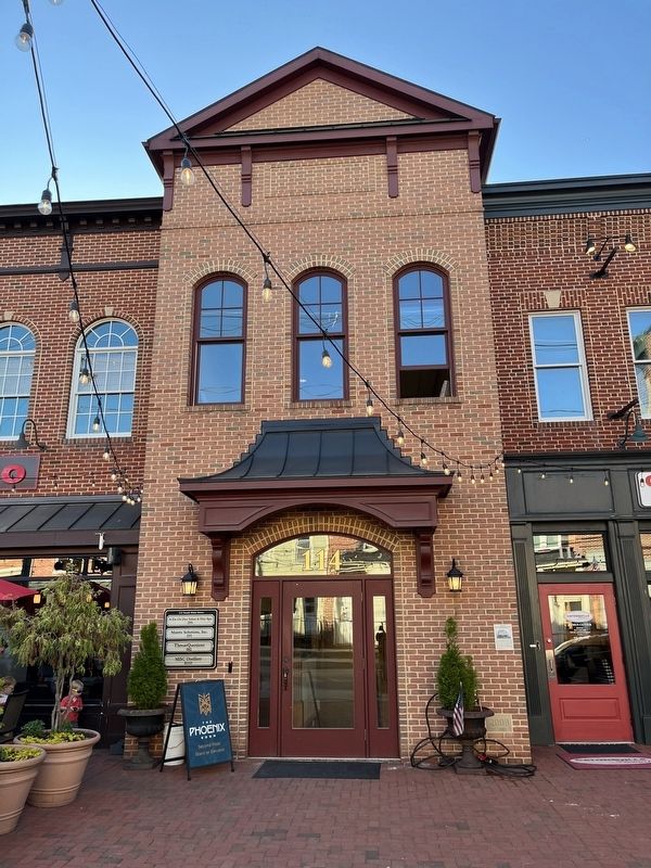
This building was originally constructed in 1957 on land owned by the B&O Railroad. It was built by Ira Watkins as the Lynn Shop, which sold ladies and children's clothes. Since then, this building has been home to:
The building in which the Gun Shack is now located was built in 1912 as the Mount Airy Post Office (shown on the left). The 3rd Floor of this building was the second site of the Mount Airy Telephone Exchange. The building has been the home to . . . — — Map (db m199417) HM
On this site there once stood the Adam Ruland Bakery, and to the right of it a private residence known as the Linthicum House. Both are shown above. The great fire of 1903 reportedly started in the flue of the store to the south of the bakery and . . . — — Map (db m199397) HM
The William Hood Building is the only structure in Mount Airy to escape destruction by fire over the years. It has been the home to several businesses including:
• Selmann and Hood General Merchandise Store
• Hood's Dry Goods . . . — — Map (db m199367) HM
This area was used for cooking meals in the summertime in order to reduce heat in the house as well as doing the laundry, canning food for the winter and storing canned and dry food. — — Map (db m188480) HM
Like it's neighbors this house is 3 story, 3 bay frame dwelling with a rear wing. Standing on a stone foundation, it is covered with weather-boards. Dr. William C. Karsner built this home c. 1884.
He served the people of . . . — — Map (db m33574) HM
This home was occupied by several notable people over the years. The bridge tender for the long bridge, Mr. Hevelow, used the railing from the bridge to fence in the yard. Capt. Ed Sheridan operated the ferry which would transverse the canal, until . . . — — Map (db m145125) HM
This building has been greatly altered since it was constructed. It maintains the continuity of the closely-built dwellings along George Street. This is another of the houses built by Thomas Conrey using the products of his mill on the causeway. . . . — — Map (db m145127) HM
The building is considered to be the oldest building in Chesapeake City. Charles and Sarah Beaston purchased Bayard House in 1809 and opened as a tavern and inn in 1829. The tavern was run by Firman Layman until his death in 1881. In 1911, it was . . . — — Map (db m144510) HM
Architecturally the Whiteoak House is representative of vernacular buildings constructed in Chesapeake City in the 1840's and 50's. Old timers in Chesapeake City claim this house rests on the 1st lot sold in town. In 1854, Richard Bayard leased the . . . — — Map (db m144831) HM
Built in 1769 as the home of Dr. Abraham Mitchell, noted physician. During the Revolutionary War he converted the house into a hospital for the use of wounded soldiers of the Continental Army. General Lafayette was a friend of the Mitchell family . . . — — Map (db m154175) HM
Directly across the street stood Washington Hall. The Institute's first building erected 1894 by Jacob Tome (1810-1898) founder and benefactor of The Tome School — — Map (db m147383) HM
This is the site of Saint Charles Roman Catholic Church. The parish began as a “Station Chapel” in the nearby home of the Charles Pye Family. Priests from St. Thomas Manor House in Port Tobacco came by on horseback to minister to the people. Saint . . . — — Map (db m6738) HM
The widow Eilbeck, mentioned in Washington’s diary, lived here. Her daughter, Ann Eilbeck, married Col. George Mason of Gunston Hall, Virginia. Araby built about 1700. — — Map (db m128784) HM
The structure known as Friendship House was rescued in 1968 from the Nanjemoy Creek site by members of the Historical Society of Charles County.
[Captions:]
Disassembly of the house was meticulous, with each piece of . . . — — Map (db m131658) HM
On this location Maj. R. G. Watson and his daughter Mary, both Confederate agents, lived and carried on a direct mail and slave route between the North and the South during the entire Civil War. Because of the unobstructed view from these cliffs, . . . — — Map (db m5938) HM
This property
Has been placed on the
National Register
Of Historic Places
By the United States
Department of the Interior
c. 1847 — — Map (db m114669) HM
Charles Goldsborough, governor of Maryland in 1818, lived in a manor house across Shoal Creek. The house was demolished in the early 1970s and this rare brick stable building is all that remains of the plantation. It was moved here in 1987 and . . . — — Map (db m138287) HM
On January 15, 2008 a major fire gutted this 1925 building and destroyed two antiques businesses. The historic structure was about to be demolished when community members rallied to save this facade so that it could remain a part of our streetscape . . . — — Map (db m205063) HM
The David and Polly Robbins Heritage Center, opened in 2007, features exhibits on Native Americans, hunting and trapping, local Dorchester County industry, including both canning and seafood. The workshop of Ron Rue, a local and internationally . . . — — Map (db m138291) HM
• Come in and explore the history of wooden boatbuilding in Dorchester County and the Chesapeake Bay.
• Meet Captain James B. ("Mr. James") Richardson and the other innovative builders who created the wooden vessels that shaped the local . . . — — Map (db m138283) HM
This colonial tenant house was built on the Spocott Farm around 1800 and was used by the Radcliffe family and those who worked for them.
Much more than an employee
This home's most well known residents were Columbus and Adaline . . . — — Map (db m205111) HM
Founded 1840 at “Tobacco Stick” Gethsemane was first pastored by Dr. E.F. Ewell in a country Schoolhouse, then in a converted barn. The final building was purchased in 1860, rebuilt in 1892 and razed in 1986. — — Map (db m114977) HM
This building was constructed sometime between 1707 and 1720 as a Chapel of Ease for members of Dorchester Parish who lived too far away from their parish church; Old Trinity Episcopal Church in Church Creek, MD, to conveniently attend services. . . . — — Map (db m114987) HM
Built in 1873 a cost of $3,500, Grace Episcopal Church was constructed as a replacement for the Chapel of Ease, now located next door to the Church, and was a part of the Dorchester Parish of the Episcopal Church. Its parent church was Old Trinity . . . — — Map (db m114986) HM
This street scene photo taken on the bridge crossing Rocky Fountain Creek around 1870, clearly shows the three white tannery buildings on the east side of Buckeystown Pike. The tanning of animal hides was the town's earliest industry. The red brick . . . — — Map (db m19385) HM
None of the structures you see here in Crampton’s Gap existed during the battle on September 14, 1862. George Alfred Townsend constructed all the stone buildings and walls, as well as the Correspondents’ Arch, between 1884 and 1896. Townsend, . . . — — Map (db m1931) HM
The house served as Union Gen. William B. Franklin's 6th Corps Headquarters on the afternoon of September 14th, 1862 during the Battle of Crampton's Gap. Owned by the Burkittsville Preservation Association, Inc. a 501c3 non-profit, 2 West . . . — — Map (db m173630) HM
James H. Gambrill prospered as a miller after the Civil War, and the family moved up in the world - from a modest dwelling on the lowlands near the mill to this 17-room house on the hill. The three-story frame structure, built about 1872, has . . . — — Map (db m194067) HM
1777 Built at direction of Maryland General Assembly
1778-79 Quartered Hessian and Convention prisoners captured at Bennington and Saratoga
1782 Quartered Hessian and Bayreuth Yager Regiments following Cornwallis' surrender
1799 . . . — — Map (db m2739) HM
The limestone barracks in front of you, built in 1778, is among the oldest and most important surviving American military structures in the nation. The barracks consisted of two L-shaped buildings, but only the eastern wing remains today. During the . . . — — Map (db m103369) HM
Sir Winston Churchill visited the Barbara Fritchie House while en route with Franklin D. Roosevelt from "Shangri-la" to Washington, D.C. — — Map (db m78351) HM
“We are conscious that it is a considerable undertaking to assume the task of editing a daily newspaper. The duties of the position are rather laborious, requiring constant attention: yet we have fully calculated the chances of success and are . . . — — Map (db m107233) HM
112 West Church St. Has been placed on the National Register Of Historic Places by the United States Department of the Interior 1814 — — Map (db m2724) HM
"Lot No. 1" on Jesserong's plat of Middletown as he laid it out in the year 1767. The Lutheran Parsonage and the two story "Lecture Hall Building" which was located to the front right of the parsonage and the little brick "Pastors Study" located . . . — — Map (db m5301) HM
This house (ca. 1830) was the birthplace of Thomas C. Harbaugh (1849-1924); One of the most popular American writers of the late 19th and early 20th centuries. His family moved to Ohio when he was 2 years old. Harbaugh wrote thousands of "Dime . . . — — Map (db m5302) HM
The first building on this corner was a two story, frame dwelling, built in the early 1800s. The property was purchased by the Middletown Savings Bank in 1907, and the house was soon moved to the rear of the lot. The current building was built in . . . — — Map (db m1870) HM
The dwelling located here at #8 West Main Street is significant as an early 19th century vernacular log building that was modified in the ca. 1930's with the application of a simulated Flemish bond brick veneer facade. It reflects the development of . . . — — Map (db m5299) HM
From 1790 to 1862, Philip Appleman (1755-1830) and his son John (1793-1862) operated a tannery and harness shop on the land that included this property and the four properties to your right, and extended back to South Street (now Washington Street). . . . — — Map (db m5312) HM
Eight thousand Confederates under Gen. Lafayette McLaws marched by this church on September 10-11, 1862, heading south to Harper’s Ferry. Since no Federals were in the area, McLaws expected no encounters with the enemy. Unknown to him, however, . . . — — Map (db m166869) HM
Presumably built by Philip Clovinger, 10 West Main began as a one-story log dwelling constructed in the early 1800's. In 1821 Thomas Powell, described as Middletown's first blacksmith, acquired the property and improved the building for commercial . . . — — Map (db m5300) HM
Given its location, the Coblentz-Long Building has associations with the growth and development of the National Pike and with the Civil War. In 1768 Conrad Crone platted the lots of the entire block 2-14 West Main, known as Smithfield, which were . . . — — Map (db m5297) HM
Built in 1888, this Queen Anne building was constructed to house the Valley Saving Bank (VSB) until 1923, and then served as a U.S. Post Office until the 1960s. When the Post Office relocated, the building began functioning as a private residence. . . . — — Map (db m107653) HM
This is the entrance to the 133.45 acre John Routzahn farm, established in 1866, known as Woodmere and located on the north and south sides of the Old National Pike. The brick manor house at 400 East Main Street was the original farm house built by . . . — — Map (db m5311) HM
1. The Central Trust Company Bank —
The Central Trust Company was an impressive Greco-Roman building on the corner of Church and West Main Streets on the square. MAny local residents lost their life's savings when the bank met its demise . . . — — Map (db m131819) HM
The ruins before you are the remains of a mansion, built ca. 1785 and known for centuries as the Ironmaster's Mansion or Catoctin Manor. The enormous house was surrounded by out-buildings, including quarters for the enslaved domestic servants and a . . . — — Map (db m184329) HM
The ruins of the Catoctin Manor are a symbol of the wealth and aristocracy originating from early industrial America. Brothers James and Thomas Johnson established Catoctin Furnace in 1774, which was highly successful in producing pig iron. Thomas . . . — — Map (db m184255) HM
(Climbing among the ruins is dangerous, damages your historic resources and it prohibited.)
One a magnificent house, the ironmaster’s mansion was an imposing structure that gave the furnace manager an overview of the furnace complex. The . . . — — Map (db m184250) HM
As early as 1750, Robert Turner bought land here on the top of South Mountain. The date of construction is unknown, but by 1790 a full-fledged inn was in operation at “Turner’s Gap.” Since then, the building has been in almost continuous use as . . . — — Map (db m1600) HM
As early as 1750, Robert Turner bought land here on the top of South Mountain. The date of construction is unknown, but by 1790 a full-fledged inn was in operation at “Turner’s Gap.” Since then, the building has been in almost continuous use as . . . — — Map (db m243581) HM
Built by the B&O Railroad, opened July 4, 1873 and operated until 1929. Razed 1942. This was one of the most exclusive mountain resorts in the east. Many nationally prominent people, including four United States Presidents, were guests here. — — Map (db m5413) HM
The Casselman Inn. You are standing in front of the Casselman Inn, which was opened in 1842 by Solomon Sterner. This establishment has also been known as Sterner House, Drovers' Inn, Farmers' Hotel and Dorsey Hotel. There was a large outdoor . . . — — Map (db m360) HM
Built in 1776 on the road between Salisbury and Pocahontas, Pa. by Solomon Glotfelty, as part of a larger log structure. Moved to Penn Alps in 1972 to be used as an artisan's studio. — — Map (db m137543) HM
This humble log cabin is a rare survivor of a common dwelling built by early settlers on the Allegheny frontier. Built after 1813 as a two-story log building, its large size has led some to believe it was once used as a tavern, giving respite to . . . — — Map (db m4921) HM
This humble log cabin is a rare survivor of a common dwelling built by early settlers on the Allegheny frontier. Built after 1813 as a two-story log building, its large size has led some to believe it was once used as a tavern, giving respite to . . . — — Map (db m243583) HM
The large stone fireplace that now stands like a sentinel along the railroad tracks is a solitary reminder of Oakland's colorful hey-day. In the late 1800’s the area from here to the B&O station was a virtual beehive of activity. With twelve . . . — — Map (db m204239) HM
The domed building on the hill to your right is the Garrett County Courthouse. Built in 1907 in a classical Greek style and designed by Architect J. Riley Gordon, this is the second building in Oakland to be called the Garrett County Courthouse. The . . . — — Map (db m487) HM
Directly behind you, John W. Garrett built Garrett Memorial Church in 1869 as a memorial to his brother Henry S. Garrett who died in 1867. The site was originally chosen by his brother for a church, but he died before steps could be taken to build . . . — — Map (db m467) HM
Facing the railroad tracks directly in front of you was the Glades Hotel. Deriving its name from the nearby area called “Youghiogheny Glades,” the Glades Hotel was built in the mid-1850’s by Perry Lyle directly across the tracks from . . . — — Map (db m468) HM
Dailey’s Park. The Garrett County Historical Society welcomes you to Dailey’s Park. This park is named in honor of John and Ann Rebecca Dailey, who owned and operated the Glades Hotel in Oakland from 1859 to 1881. Historian Thomas Scharf noted . . . — — Map (db m466) HM
[Top plaque:]
1896
Baker House
[Center plaque:]
This property has been
placed on the
National Register
of Historic Places
by the United States
Department of the Interior
[Lower plaque:] . . . — — Map (db m138215) HM
Founded in 1671. First church erected at Gravelly near Michaelsville, the three succeeding churches erected on the present location, one mile south of this point. Colonial vestry house erected 1766. — — Map (db m146955) HM
Court House erected 1791. Burned and re-erected 1858. Enlarged 1904. Portraits of notable men born in Harford adorn court room, including Edwin Booth, who gave his first theatrical performance there. — — Map (db m1225) HM
The Liriodendron mansion was built in 1898 as a summer home away from the heat of the Kellys’ Mount Vernon home. The mansion was named after the tulip poplar trees that shade the 200-acre grounds. The Kelly family lived in the mansion until the . . . — — Map (db m173896) HM
The slate-roofed stone building at the bottom of the hill is a springhouse. It was built in the early 19th century to protect a source of drinking water for the people living in the house on the hill. Archer Hays had the house built in 1808, and the . . . — — Map (db m177536) HM
Solid wooden beams frame and support the slate roof
The windows with louvered covers allow fresh air to circulate
Sturdy shelf for items that need not be kept as cold
Thick stone walls built into side of the hill protect the water source . . . — — Map (db m177537) HM
One of the earliest buildings in Bel Air. Enlarged in 1814 by Thomas A. Hays (1780–1861), an attorney, landowner and entrepreneur. Moved to present location in 1960. Retains original interior features and woodwork, weatherboard and shutters. — — Map (db m159925) HM
Concord Point, like all lighthouses, was run by the United States
Lighthouse Establishment (LHE). All building projects were
approved and paid for by the LHE.
Several outbuildings were added to the Keeper's House property
including a well in . . . — — Map (db m164220) HM
Several outbuildings were added to the property after the initial construction of the Keeper’s House.
A well was dug in 1827 and research indicated that a pump was installed to draw water.
The pump house was added over the well in 1851. This . . . — — Map (db m165843) HM
On the point where the mighty Susquehanna River meets the Chesapeake Bay stands the lighthouse that protected vessels from dangerous waters for 148 years.
Built in 1827 to protect vessels from dangerous shoals and currents at the mouth of the . . . — — Map (db m164071) HM
Prior to the building of the Conowingo Dam in 1928, this area
flooded every spring when the snow melted. Light keepers used
a boat to go from the house to the lighthouse in order to light the lamps.
Raised wooden walkways were constructed . . . — — Map (db m164989) HM
This area has always been susceptible to flooding. Several times throughout the year, the entire property would have been under water. There are reports of light keepers taking a boat from the house to the lighthouse in order to light the . . . — — Map (db m165844) HM
Havre de Grace resident John Donahoo constructed the
lighthouse Keeper's House with attached kitchen, as well as
the lighthouse in 1827. It was originally a one and half story
structure measuring 34 by 20 feet with two rooms and an
attached . . . — — Map (db m164975) HM
Canvasback ducks float quietly on the water The hunter waits Flocks of ducks appear in the sky, cup their wings and drop down to the waiting canvasbacks The hunter's ploy has worked For it was not real canvasbacks that lured the ducks but well . . . — — Map (db m161524) HM
In 1920, the Keeper's House and property were sold by the U.S. Government.
The light had been automated and a keeper was no longer necessary.
The building became a boarding house until the mid-1930s. It then
became a bar, dance hall and . . . — — Map (db m164986) HM
The Rock Run Mill was built in 1794 by John Stump, a prominent businessman, on land originally known as “Land of Promise.” The mill was in continuous operation until 1954. It is one of the oldest mills still standing in Harford County.
The . . . — — Map (db m188608) HM
363 entries matched your criteria. Entries 101 through 200 are listed above. ⊲ Previous 100 — Next 100 ⊳