4036 entries match your criteria. The first 100 are listed. ⊳
Exploration Topic
By Mark Hilton, August 22, 2018
A County Older Than the State, Baldwin County Marker (reverse)
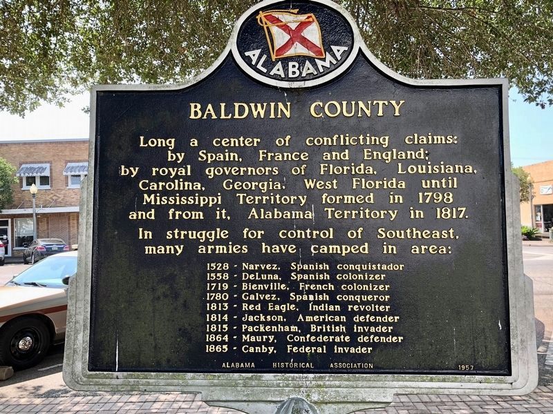
| 1 ► Alabama, Baldwin County, Bay Minette — A County Older Than the State, Baldwin County — |
| On Courthouse Square (U.S. 31) at Hand Avenue, on the left when traveling east on Courthouse Square. | |||
| 2 ► Alabama, Baldwin County, Gulf Shores — Indian Village Achuse — |
| On Alabama Route 180 east of Gasque Lane, on the right when traveling west. | |||
| 3 ► Alabama, Baldwin County, Magnolia Springs — The Springs — |
| Near Magnolia Springs Highway (County Route 49) 0.1 miles east of Oak Street. | |||
| 4 ► Alabama, Baldwin County, Spanish Fort — Bay of the Holy Spirit — |
| On Battleship Parkway (U.S. 98) near Interstate 10, on the right when traveling east. | |||
| 5 ► Alabama, Baldwin County, Spanish Fort — Caisson Trace — |
| On Caisson Trace at Spanish Main Street, on the left when traveling west on Caisson Trace. | |||
| 6 ► Alabama, Baldwin County, Spanish Fort — Spanish Fort — |
| On Spanish Main Street north of Spanish Fort Boulevard (U.S. 31), on the right when traveling north. | |||
| 7 ► Alabama, Butler County, Greenville — Bartram's Trail — |
| On Sherling Lake Road (County Road 44) 1 mile west of Braggs Road (State Route 263), on the right when traveling west. | |||
| 8 ► Alabama, Calhoun County, Oxford — The "Shattering" of the Mississippian World — AD 1540 to AD 1730 — Choccolocco Park Interpretive Trail — |
| Near Leon Smith Parkway. | |||
| 9 ► Alabama, Cherokee County, Cedar Bluff — Indian Village of Costa — |
| On Old Alabama Route 9 west of Sewell Ferry Road, on the right when traveling west. | |||
| 10 ► Alabama, Choctaw County, Gilbertown — First Oil Well In Alabama — |
| On Paragon Road (County Road 16) 2 miles west of State Route 17, on the left when traveling west. | |||
| 11 ► Alabama, Clay County, Delta — Home Sweet Home — |
| 12 ► Alabama, Cleburne County, Muscadine — Hernando de Soto in Alabama — |
| Near Interstate 20 (Interstate 20) west of Alabama Route 37, on the right when traveling west. | |||
| 13 ► Alabama, Colbert County, Muscle Shoals — Explore the River — |
| On Reservation Road. | |||
| 14 ► Alabama, Dallas County, Cahaba — Alabama's Native Prairie |
| On Capitol Street at Cahaba Road, on the right when traveling east on Capitol Street. Reported permanently removed. | |||
| 15 ► Alabama, DeKalb County, Sulphur Springs — The De Soto Trail — Hernando De Soto In Alabama — |
| Near Interstate 59, 1 mile north of County Road 140, on the right when traveling south. | |||
| 16 ► Alabama, DeKalb County, Sulphur Springs — The De Soto Trail — |
| Near Interstate 59, 1 mile north of County Road 140, on the right when traveling south. | |||
| 17 ► Alabama, Elmore County, Wetumpka — Bartram's Trail — |
| On West Fort Toulouse Road, 0.1 miles west of U.S. 231, on the right when traveling west. | |||
| 18 ► Alabama, Elmore County, Wetumpka — William Bartram Arboretum — 1739 - 1823 — |
| Near West Fort Toulouse Road, 0.2 miles south of Jackson Park Road. | |||
| 19 ► Alabama, Houston County, Columbia — Omussee Creek Mound and the Ancestors of the Creeks — Creek Heritage Trail — |
| On Omussee Creek Road, 0.5 miles north of Picnic Road, on the right when traveling north. | |||
| 20 ► Alabama, Houston County, Cottonwood — Southern Boundary of the United States — 1795-1819 — |
| On U.S. 231 at State Line Road, on the right when traveling north on U.S. 231. | |||
| 21 ► Alabama, Lauderdale County, Florence, East Florence — Jesse Clopton James — City of Florence Walk of Honor — |
| On Hightower Place. | |||
| 22 ► Alabama, Lee County, Smiths Station — Line 32° 28´ North Latitude — |
| On County Road 430, 0.6 miles south of County Road 248, on the left when traveling south. | |||
| 23 ► Alabama, Limestone County, Ardmore — Hernando De Soto in Alabama — De Soto Trail — |
| 24 ► Alabama, Lowndes County, Tyler — Talisi visited by De Soto — Sept. 18, 1540 — |
| On U.S. 80 at County Road 7, on the right when traveling west on U.S. 80. | |||
| 25 ► Alabama, Macon County, Tuskegee — Bartram's Trail — |
| On Forest Road 949, 0.2 miles north of State Route 186, on the left when traveling north. | |||
| 26 ► Alabama, Madison County, Huntsville — Armstrong • Collins • Aldrin — Launched: July 16, 1969 • Landed: July 20, 1969 • Splashdown: July 24, 1969 — "That's one small step for a man, one giant leap for mankind." — |
| Near Tranquility Base, 0.5 miles west of Old Madison Pike NW, on the left when traveling west. | |||
| 27 ► Alabama, Madison County, Huntsville — Cernan • Evans • Schmitt — Launched: December 7, 1972 • Landed: December 11, 1972 • Splashdown: December 19, 1972 — "...America's challenge of today has forged man's destiny of tomorrow." — |
| Near Tranquility Base, 0.5 miles west of Old Madison Pike NW, on the left when traveling west. | |||
| 28 ► Alabama, Madison County, Huntsville — Conrad • Gordon • Bean — Launched: November 14, 1969 • Landed: November 19, 1969 • Splashdown: November 24, 1969 — "I see the Surveyor! I see the Surveyor!" — |
| Near Tranquility Base, 0.5 miles west of Old Madison Pike NW, on the left when traveling west. | |||
| 29 ► Alabama, Madison County, Huntsville — External Tank — Liquid Propellent Supply for Space Shuttle Main Engines — |
| Near Tranquilty Base, 0.5 miles west of Madison Pike, on the left when traveling west. | |||
| 30 ► Alabama, Madison County, Huntsville — Lovell • Swigert • Haise — Launched: April 11, 1970 • Splashdown: April 17, 1970 — "Okay Houston, Hey, We've got a problem here..." — |
| On Tranquility Base, 0.5 miles west of Old Madison Pike NW, on the left when traveling west. | |||
| 31 ► Alabama, Madison County, Huntsville — McDivitt • Scott • Schweickart / Stafford • Young • Cernan — Launched: March 3, 1969 • Splashdown: March 13,1969 — Launched: May 18, 1969 • Splashdown: May 26, 1969 — |
| Near Tranquility Base, 0.5 miles west of Old Madison Pike NW, on the left when traveling west. | |||
| 32 ► Alabama, Madison County, Huntsville — Ms. Baker: Monkeynaut — |
| Near Tranquility Base, 0.5 miles west of Madison Pike, on the left when traveling west. | |||
| 33 ► Alabama, Madison County, Huntsville — Saturn V — |
| Near Tranquility Base, 0.5 miles west of Old Madison Pike NW, on the left when traveling west. | |||
| 34 ► Alabama, Madison County, Huntsville — Schirra • Eisele • Cunningham / Borman • Lovell • Anders — Launched: October 11, 1968 • Splashdown: October 22, 1968 — Launched: December 21, 1968 • Splashdown: December 27, 1968 — |
| Near Tranquility Base, 0.5 miles west of Old Madison Pike NW, on the left when traveling west. | |||
| 35 ► Alabama, Madison County, Huntsville — Scott • Worden • Irwin — Launched: July 26, 1971 • Landed: July 30, 1971 • Splashdown: August 7, 1971 — "It's really rolling hills, up and down we go, buckin' bronco!" — |
| Near Tranquility Base, 0.5 miles west of Old Madison Pike NW, on the left when traveling west. | |||
| 36 ► Alabama, Madison County, Huntsville — Shepard • Roosa • Mitchell — Launched: January 31, 1971 • Landed: February 5, 1971 • Splashdown: February 9, 1971 — "...It's been a long way, but we're here." — |
| Near Tranquility Base, 0.5 miles west of Old Madison Pike NW, on the left when traveling west. | |||
| 37 ► Alabama, Madison County, Huntsville — U.S. Army/NASA Juno II — |
| Near Tranquility Base, 0.5 miles west of Madison Pike, on the left when traveling west. | |||
| 38 ► Alabama, Madison County, Huntsville — Young • Mattingly • Duke — Launched: April 16, 1972 • Landed: April 20, 1972 • Splashdown: April 27, 1972 — "Look at the size of that rock!" — |
| Near Tranquility Base, 0.5 miles west of Old Madison Pike NW, on the left when traveling west. | |||
| 39 ► Alabama, Marshall County, Guntersville — Indian Village Tali — |
| On Gunter Avenue (U.S. 431) at Court Street, on the left when traveling south on Gunter Avenue. | |||
| 40 ► Alabama, Mobile County, Dauphin Island — Dauphin Island — |
| On Bienville Boulevard at Lackland Street, on the right when traveling east on Bienville Boulevard. | |||
| 41 ► Alabama, Mobile County, Grand Bay — William Bartram Trail — Traced 1773-1777 — Deep South Region — |
| Near Interstate 10, 2 miles east of Franklin Creek Road. | |||
| 42 ► Alabama, Mobile County, Le Moyne — Ellicott's Stone — Erected April 9th, 1799 |
| On U.S. 43 at milepost 19,, 0.1 miles south of Lofton Road, on the right when traveling north. Reported damaged. | |||
| 43 ► Alabama, Mobile County, Mobile — Crown & Scepter of Isabel — |
| Near Government Street (U.S. 90) just east of South Hamilton Street, on the right when traveling east. | |||
| 44 ► Alabama, Mobile County, Mobile — Hernando de Soto — C 1500-1542 — |
| Near South Franklin Street south of Government Street (U.S. 90), on the left when traveling north. | |||
| 45 ► Alabama, Mobile County, Mobile — Isabel La Catolica — 1451-1504 — |
| Near Government Street (U.S. 90) just east of South Hamilton Street, on the right when traveling east. | |||
| 46 ► Alabama, Mobile County, Mobile — Our Spanish Heritage — |
| On Government Street (U.S. 90) east of South Hamilton Street, on the right when traveling east. | |||
| 47 ► Alabama, Mobile County, Mobile — Pierre Le Moyne d'Iberville — |
| On St Francis Street at North Conception Street, on the right when traveling east on St Francis Street. | |||
| 48 ► Alabama, Mobile County, Mobile — Tristan de Luna y Arellano — 1519–1573 — |
| Near Battleship Parkway (U.S. 98) 0.7 miles south of Interstate 10, on the right when traveling east. | |||
| 49 ► Alabama, Montgomery County, Maxwell Air Force Base — Site of Indian Town Tawasa — 1540-1814 — |
| Near West Hickory Street at Chennault Circle when traveling west. | |||
| 50 ► Alabama, Montgomery County, Montgomery — Alabama River: The Grand Avenue — |
| Near Water Street west of Whitman Street, on the right when traveling west. | |||
| 51 ► Alabama, Montgomery County, Montgomery — Europeans Along the Alabama River — |
| Near Water Street. | |||
| 52 ► Alabama, Montgomery County, Montgomery — Struggle For Colonial Empire — |
| Near Water Streer at Commerce Street, on the right when traveling west. | |||
| 53 ► Alabama, Pickens County, Aliceville — George Downer Field — Aliceville, Alabama — Dedicated Nov. 7, 1961 — |
| On Alabama Route 17, 0.2 miles south of Iron Bridge Road, on the right when traveling south. | |||
| 54 ► Alabama, Russell County, Fort Mitchell — Archaeology And Our Understanding of the Creek People — Creek Heritage Trail — |
| Near County Route 165, 2.3 miles south of Nuckols Road (Road 39). | |||
| 55 ► Alabama, Russell County, Phenix City — The Creek Town of Coweta — Creek Heritage Trail — |
| Near Dillingham Street at Brickyard Road (Route 61). | |||
| 56 ► Alabama, Russell County, Phenix City — William Bartram Trail — Traced 1773-1777 — Deep South Region |
| On U.S. 280 just east of General Colin Powell Parkway, in the median. Reported missing. | |||
| 57 ► Alabama, St. Clair County, Pell City — None — A County Older Than The State — St. Clair County — |
| On Cogswell Avenue at 18th Street, on the right when traveling west on Cogswell Avenue. | |||
| 58 ► Alabama, Sumter County, York — Line 32° 28´ North Latitude — |
| On 4th Avenue (U.S. 11) 0.6 miles north of Longshore Drive, on the right when traveling north. | |||
| 59 ► Alabama, Talladega County, Childersburg — Coosa — |
| On Plant Road (Alabama Route 235 at milepost 2), on the left when traveling north. | |||
| 60 ► Alabama, Talladega County, Childersburg — De Soto's Visit — |
| On U.S. 280 at Childersburg Fayettville Highway (State Highway 76), on the right when traveling south on U.S. 280. | |||
| 61 ► Alabama, Talladega County, Childersburg — History Of Childersburg — |
| On 1st Street Southwest (State Highway 76) at 6th Avenue Southwest, on the right when traveling east on 1st Street Southwest. | |||
| 62 ► Alabama, Talladega County, Childersburg — The De Soto Trail / Chief Coosa And His Dominion — Alabama De Soto Trail — |
| On U.S. 280 at Childersburg Fayettville Highway (State Highway 76), on the right on U.S. 280. | |||
| 63 ► Alabama, Washington County, Chatom — Washington County — First County in Alabama — |
| On Court Street north of Central Avenue (Alabama Route 56), on the left when traveling north. | |||
| 64 ► Alaska, Anchorage — Captain James Cook — R.N., F.R.S. — Navigator, Explorer, Chartmaker, Scientist, Humanist / 1728 – 1779 — |
| Near L Street. | |||
| 65 ► Alaska, Anchorage — Resolution Park 1776 / 1778 — |
| On L Street, on the right when traveling south. | |||
| 66 ► Alaska, Fairbanks North Star Borough, Fairbanks — Alaska's Gold Rush Era — |
| On Richardson Highway (Alaska Route 2), on the right when traveling south. | |||
| 67 ► Alaska, Fairbanks North Star Borough, Fairbanks — Tanana Valley Gold — |
| On Richardson Highway (Alaska Route 2), on the right when traveling south. | |||
| 68 ► Alaska, Juneau Borough, Juneau, Twin Lakes — Wagner Mine — |
| On Salmon Creek Lane. | |||
| 69 ► Alaska, Sitka Borough, Sitka — 250th Anniversary of the Bering- Chirikov Expedition — 1741-1991 — |
| 70 ► Alaska, Sitka Borough, Sitka — Noow Tlein — |
| 71 ► Alaska, Skagway — Skagway Centennial Statue — 1897 — |
| On Broadway, on the right when traveling north. | |||
| 72 ► Arizona, Apache County, Lupton — One Days Ride to Zuni — |
| Near Interstate 40 at milepost 359. | |||
| 73 ► Arizona, Cochise County, Bisbee — Discovery of Ore |
| On Arizona Route 80 at milepost 341,, 0.2 miles west of Main Street, on the right when traveling west. Reported missing. | |||
| 74 ► Arizona, Cochise County, Bowie — Parke Camp Site — |
| Near Fort Bowie Trail, 0.4 miles south of Apache Pass Road. | |||
| 75 ► Arizona, Cochise County, Hereford — The Coronado Expedition, 1540-42 — |
| Near East Montezuma Canyon Road.. | |||
| 76 ► Arizona, Coconino County, Flagstaff — Beale Road — Historic Site — |
| On U.S. 180, on the right when traveling north. | |||
| 77 ► Arizona, Coconino County, Flagstaff — Henry Lee Giclas — December 10, 1910 - April 2, 2007 — |
| Near West Mars Hill Road, 0.6 miles west of West Santa Fe Avenue. | |||
| 78 ► Arizona, Coconino County, Flagstaff — Lowell Observatory — National Historic Landmark — |
| Near West Mars Hill Road, 0.6 miles west of West Santa Fe Avenue. | |||
| 79 ► Arizona, Coconino County, Flagstaff — The Lawrence Lowell Telescope — |
| Near West Mars Hill Road, 0.6 miles west of West Santa Fe Avenue. | |||
| 80 ► Arizona, Coconino County, Fredonia — 29 — Pipe Springs National Monument — |
| On U.S. 89A at milepost 609, on the left when traveling north. | |||
| 81 ► Arizona, Coconino County, Fredonia — Prickly Pears and Pinion Nuts — Dominguez y Escalante Expedition 1776-1976 — |
| On U.S. 89A at milepost 609, on the left when traveling north. | |||
| 82 ► Arizona, Coconino County, Grand Canyon National Park — Bright Angel Trail — |
| 83 ► Arizona, Coconino County, Grand Canyon National Park — Colonel Claude Hale Birdseye — 1878-1941 — Explorer • Geographer • Surveyor — |
| Near Hermit Road. | |||
| 84 ► Arizona, Coconino County, Grand Canyon National Park — Early Explorer — |
| On Hermits Road, on the right when traveling east. | |||
| 85 ► Arizona, Coconino County, Grand Canyon National Park — Kolb Studio — Grand Canyon National Park — |
| 86 ► Arizona, Coconino County, Grand Canyon National Park — Mining on Horseshoe Mesa — |
| 87 ► Arizona, Coconino County, Grand Canyon National Park — The Best Section — |
| Near Hermit Road at West Rim Trail. | |||
| 88 ► Arizona, Coconino County, Grand Canyon Village — Spanish Discovery — |
| Near Desert View Drive (Arizona Route 64) 14.6 miles east of South Entrance Road, on the left when traveling east. | |||
| 89 ► Arizona, Coconino County, Marble Canyon — Dominguez y Escalante Expedition — 1776 - 1976 — Treacherous Descent |
| On U.S. 89A at milepost 557, on the left when traveling east. Reported missing. | |||
| 90 ► Arizona, Coconino County, Marble Canyon — Impossible Canyons — Dominguez y Escalante Expedition 1776-1976 — |
| On U.S. 89A at milepost 538.3, on the right when traveling west. | |||
| 91 ► Arizona, Coconino County, Page — Crossing of the Fathers — Dominguez y Escalante Expedition 1776-1976 — |
| On Lake Powell Boulevard at Navajo Drive, on the right when traveling north on Lake Powell Boulevard. | |||
| 92 ► Arizona, Coconino County, Page — Emma Dean — |
| On Lake Powell Boulevard at Navajo Drive, on the right when traveling north on Lake Powell Boulevard. | |||
| 93 ► Arizona, Coconino County, Page — Major John Wesley Powell — 1834-1902 — |
| Near U.S. 89. | |||
| 94 ► Arizona, Coconino County, Sunset Crater Volcano National Monument — "The Peaks" — |
| 95 ► Arizona, Coconino County, Sunset Crater Volcano National Monument — Geological Infant — |
| 96 ► Arizona, Coconino County, Walnut Canyon National Monument — A Time of Change — |
| 97 ► Arizona, Coconino County, Williams — Bill Williams Mountain — Elevation 9,264 Ft — |
| On West Bill Williams Avenue/West Route 66, on the left when traveling east. | |||
| 98 ► Arizona, Coconino County, Williams — William Sherley Williams — Sculpture by B.R. Pettit — |
| On East Railroad Avenue near South 9th Street, in the median. | |||
| 99 ► Arizona, Graham County, Safford — The Gila Valley |
| On U.S. 70 at milepost 341, on the right when traveling east. Reported missing. | |||
| 100 ► Arizona, Greenlee County, Clifton — San Francisco River — |
| On The Coronado Trail (U.S. 191 at milepost 163), on the right when traveling north. | |||
4036 entries matched your criteria. The first 100 are listed above. Next 100 ⊳