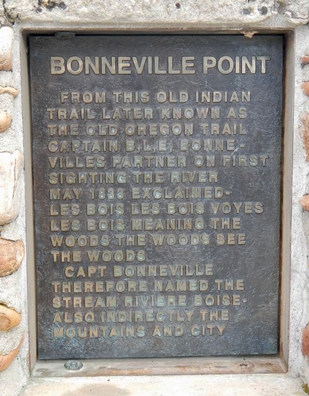
From this old Indian trail later known as the Old Oregon Trail Captain B,L,E, Bonnevilles partner on first sighting the river May 1833 exclaimed - Les Bois Les Bois Voyes Les Bois meaning The Woods The Woods See The Woods
Capt Bonneville . . . — — Map (db m71837) HM
From the high ridge above the Boise River 5 miles southwest of here, westward-bound travelers got their first view of the Boise Valley. In 1811, Wilson Price Hunt and the Overland Astorians' party were the first white sojourners to enjoy the scene. . . . — — Map (db m119002) HM
Bonneville Point
According to tradition, a hunting party led by the explorer Captain Benjamin Bonneville reached this promontory in 1833. They saw the lush river valley below and exclaimed in French, “Les bois; les bois; vouyez . . . — — Map (db m71835) HM
Sacajawea and Pomp
Sacajawea was a Lemhi Shoshoni Indian born near Salmon, Idaho around 1790. She was the only Idaho native, and the only female, to be a member of the famed Lewis and Clark "Corps of Discovery" expedition that opened up the . . . — — Map (db m73205) HM
Hunt’s party laid the groundwork for future trapping expeditions across the Snake River Plain. Donald Mackenzie, who accompanies Hunt and later joined the British North West Company, returned to establish trade relations with resident Indian bands. . . . — — Map (db m71834) HM
Beaver pelts lured the first Euro-Americans deep into the American West. In 1810, only four years after Lewis and Clark completed their epic journey, John Jacob Astor established the Pacific Fur Company. He soon financed sea and land expeditions to . . . — — Map (db m71832) HM
Discovered in 1812 by trappers returning home from Astoria, Oregon, this valley and its large lake soon became an important fur trade center.
Donald Mackenzie, Jim Bridger and a host of famous beaver hunters operated here. Two major summer . . . — — Map (db m105867) HM
In 1870, Brigham Young appointed Ezra T. Clark, David Hess, and Nicholas Barkdull to colonize this area.
Originally known a Twin Creeks, Joseph C. Rich surveyed the site in 1871. In 1872, the new settlement was named Georgetown in honor . . . — — Map (db m140244) HM
Capt. John Mullan U.S. Army
Capt. John Mullan, US Army, Constructor and surveyor.
He was directed to mark a wagon and railroad route from Fort Benton, Montana to Walla Walla, Washington from 1853-1855.
He built the actual road . . . — — Map (db m110000) HM
An old emigrant road headed west across Camas Prairie and then descended to the valley below on its way to rejoin the Oregon Trail 28 miles west of here.
This route, discovered by Donald Mackenzie's fur trade party in 1820, came into use for . . . — — Map (db m125602) HM
As the pioneers passed through this parched landscape they were happy to find any available water.
Most water is soaked up like a giant sponge when it reaches the lava fields, but here, small creeks to the north cover the porous lava rock with a . . . — — Map (db m109897) HM
Searching the mountain wilderness for beaver, Alexander Ross came up Wood River and discovered this summit, Sept. 18, 1824.
Leading a large brigade of Hudson's Bay Company trappers, he wondered whether he ever could get through unknown . . . — — Map (db m110051) HM
The Payette River is named for Francois Payette, a French-Canadian trapper and early explorer of the major tributaries of the Snake River. At that time, British, Canadian, and American fur companies competed for the region's abundant natural . . . — — Map (db m119236) HM
At Mamaloose Point, two miles
South, Kullyspell house,
first trading post in Idaho,
was built September, 1809 by
David Thompson
and
Finnan Macdonald — — Map (db m112928) HM
Idaho’s fur trade began in the fall of 1809 when David Thompson built a trading post 2½ miles southwest of here. Kullyspell House (Thompson spelled “Kalispell” that way) was the earliest fur trade post in the American Pacific . . . — — Map (db m112927) HM
Coming from Canada, the famous map maker and trader for the North West Company explored this area and river in 1808.
On May 8 somewhere near here, Thompson's famished party, all sick from eating a "much tainted" antelope, met ten lodges of . . . — — Map (db m122201) HM
In this area are a group of springs famous to Oregon Trail travelers, most of whom stopped to try the "acid taste and effervessing gasses" of the waters.
Earlier, fur traders often -- less elegantly -- called the place "Beer Springs" after . . . — — Map (db m105967) HM
(left panel:)
Tour Our National Byways
Click on the Tour Our National Byways photograph to enlarge it and view the local byway routes. (center panel:)
The springs of Soda Springs - indeed a . . . — — Map (db m106214) HM
This is an east-west travel corridor of the earliest emigrant trails that continued even after the arrival of railroads and highways. Early explorers, such as John Fremont, Jedediah Smith, Osborne Russell, and missionary Narcissi Whitman were among . . . — — Map (db m106846) HM
Discovered this valley in 1818 or 1819 while hunting beaver for Donald MacKenzie's Northwest Company trappers.
An Iroquois leader -- he also explored Grey's River nearby in Wyoming. Aside from his trapping skills, he was noted for his unusual . . . — — Map (db m105964) HM
You are nearing the junction of historic Highway 11, now designated as Gold Rush Historic Byway.
Winding its way through spectacular scenery, it passes through the traditional homeland of the Nez Perce Indians on the Weippe Prairie and the National . . . — — Map (db m109758) HM
Founded by Seth S. Slater, May 6, 1861, Slaterville (permanent population, 50) had 5 edifices – built mainly of colored blankets – 2 stores, 2 houses, and a saloon.
When the Colonel Wright “snapped her tow-line on the Grand Rapids . . . — — Map (db m110703) HM
The brass monument nearby is provided by the Idaho Society of Professional Land Surveyors in cooperation with the National Geodetic Survey to commemorate the “Lewis and Clark” Corps of Discovery campsite at Canoe Camp, Idaho.
. . . — — Map (db m110468) HM
Lewis and Clark called this place Canoe Camp.
For 11 days in 1805 the Corps of Discovery camped here in the company of Nez Perce while building five canoes for the journey to the Pacific.
For thousands of years before that, this riverbank was . . . — — Map (db m110465) HM
Guided by Twisted Hair and several other Nez Perce, Capt. William Clark selected this as a camp site because of the many large ponderosa pines that grew here then. The canoe makers chopped out small portions of the pine logs, then used fire or . . . — — Map (db m109875) HM
Welcome to
Canoe Camp
One of 38 sites of Nez Perce National Historical Park
These grounds have been inhabited for thousands of years by the Nez Perce people, but are best known as the place where the Lewis and Clark . . . — — Map (db m109872) HM
After more than a month’s search, they finally had reached a westward river where they could use canoes.
From here they continued another 16 miles with their pack horses before they found a campsite with trees suitable for making canoes.
But at . . . — — Map (db m109757) HM
When the Lewis and Clark Corps of Discovery entered this area in September 1805, they were not only hungry, but still anxious to locate a water route to the Pacific Ocean.
Under the direction of a Nez Perce headman, Twisted Hair, the explorers . . . — — Map (db m159484) HM
Orofino is situated on the north and south banks of the Clearwater River.
The area’s mild climate and convenient location made it a thriving Nez Perce village site long before Lewis and Clark stopped here in 1805.
Lumberjack Days
. . . — — Map (db m109888) HM
Canoe Camp is part of the Nez Perce National Historical Park and a key site along the Northwest Passage Scenic Byway
An Interesting Drive
The 202-mile Northwest Passage Scenic Byway stretches from Lewiston to Lolo Pass on US Highway . . . — — Map (db m109886) HM
After the hardships of the mountain passage, the Weippe Prairie was a place of relief for the Corps of Discovery. The Nez Perce befriended them and renewed their hope of reaching the Pacific Ocean.
"the pleasure I now felt in having tryumphed . . . — — Map (db m121438) HM
The brass monument nearby is provided by the Idaho Society of Professional Land Surveyors to commemorated the "Lewis and Clark" Corps of Discovery campsite near Weippe Prairie, Idaho.
Datum NAD 83 and NAVD88
Latitude N 46º21' 00" Latitude . . . — — Map (db m121581) HM
I Set out early and proceeded ... to a Small Plain in which I found maney Indian lodges ... I met 3 Indian boys, when they saw me they ran and hid themselves. -- Capt. William Clark, September 20, 1805
After Lewis and Clark's Corps of . . . — — Map (db m121582) HM
In late September of 1805, three young Nez Perce spied several men dressed in strange clothes and hats coming from the ridge to the southeast. The boys hid, but the men discovered two of them in the area behind this sign. The boys led these men to . . . — — Map (db m232854) HM
Journeying toward the Clearwater, 6 men under Clark met the Nez Perce Indians not far from here, September 20, 1805.
Clark first saw 3 frightened Indian boys who hid in the grass. Finding two, he reassured them with small presents and "Sent . . . — — Map (db m121439) HM
This marker was dedicated
1957
to commemorate the arrival of the Lewis and Clark Expedition at Weippe Prairie, Idaho, Sept. 23, 1805. Also to honor the memory of Dr. J.T. Moser who pioneered here in the 1890's and to honor the memory of his . . . — — Map (db m121440) HM
This Valley was discovered in 1822 by an expedition of Hudson's Bay Company trappers led by Michel Bourdon. Bourdon had come to the Northwest with David Thompson, who had started the Idaho fur trade in 1808-9. Trappers searched everywhere for . . . — — Map (db m59949) HM
Long before miners and ranchers settled Stanley Basin, bears dominated this area.
When Alexander Ross and his Hudson’s Bay Company trappers stopped here, September 20, 1824, they “observed at some distance the appearance of a ploughed . . . — — Map (db m110042) HM
Alexander Ross and his Hudsons Bay Company fur trappers were the first white men to visit these hot springs. His dairy describes camping "at the boiling fountain" when they came here on October 1, 1824.
Hot springs result when hot water reached . . . — — Map (db m110040) HM
The Pass of the Standing Rock was held sacred by the ancient ones of the Shoshone and other Native American Tribes long before John C. Fremont's exploratory party came to Weston Canyon on August 29, 1843. Fremont's surveyors spent the entire day . . . — — Map (db m140345) HM
John Colter after serving with the Lewis and Clark Expedition journeyed to the Teton Yellowstone Country in 1807, and became the first mountain man to see the Teton Mountain Range. Early fur trappers gathered in the valley at the base of the Teton . . . — — Map (db m108571) HM
was built in the fall of 1810 by Captain Andrew Henry and his companions of the Missouri Fur Company, about five miles below here on the left bank of this stream (Henry's Fork of Snake River), first buildings erected by Americans in the present . . . — — Map (db m108980) HM
Malad History
If eating food somewhere made you sick, how would you warn others of the danger? Fur trappers and traders named the Malad River the Riviere Aux Malad, or “sickly river,” after becoming hill from eating beaver . . . — — Map (db m71603) HM
On May 31, 1806, Sgt. John Ordway and Pvts. Frazer and Weiser began the return trip from Lewis’s (sic) River (Snake River) with salmon for Camp Chopunnish (Kamiah). The men crossed the Camas Prairie near here on their way to rejoin the Corps . . . — — Map (db m121141) HM
The Lewis and Clark Expedition passed through the valley of Hungery Creek in late September 1805, and on their return journey in late June, 1806. Five of the party's campsites are located in this valley to the south. Here you can see the extent of . . . — — Map (db m140826) HM
Arriving here in late September 1805, Captain Lewis and a contingent of the Corps of Discovery were cold and hungry. Wearing only worn moccasins, they had struggled over rough, hilly terrain. Climbing over fallen trees and through log strewn creek . . . — — Map (db m140834) HM
On June 17, 1806, the Lewis and Clark Expedition left their camp in Hungery Creek to ascend into the mountains. The party encountered deep snow at the top of the ridge and was forced to turn back. Captain Lewis wrote, "...this is the first time . . . — — Map (db m140829) HM
In June 1806, the Lewis and Clark Expedition members were in good spirits as they began their journey home over the Lolo Trail. Although the men were well fed, rested an had 66 horses to ride and carry their gear, the trails were still very slippery . . . — — Map (db m140832) HM
"The country is thickly covered with a very heavy growth of pine of which I have ennumerated 8 distinct species." Capt. Meriwether Lewis, September 19, 1805
The landscape today may look very similar to the one Lewis and Clark described, . . . — — Map (db m140828) HM
(Three panels outline the history of Tolo Lake)
The Nez Perce name for this lake is Tipahxlee’whum (Tepahlewam or Split Rocks). In early June 1877, five bands of Nimiipuu gathered here for their last taste of freedom before . . . — — Map (db m121267) HM
In May and June, they camped across the river from present-day Kamiah near the railroad bridge.
With their Nez Perce friends, they hunted, traded and played games.
They showed the Nez Perce “the power of magnetism, the spye glass, compass, . . . — — Map (db m109771) HM
Look north to the ridgeline behind you and see what Lewis and Clark and the Corps of Discovery faced on the morning of September 15, 1805. At 7 a.m. the Corps left their Colt Killed Camp near what is now the Powell Ranger Station.
Hoping for a . . . — — Map (db m123161) HM
President Thomas Jefferson, driven by a life-long passion for scientific exploration and study, instructed Meriwether Lewis to record details about the flora, fauna, geology and people of the land between the Missouri River and the Pacific Ocean. As . . . — — Map (db m123162) HM
In September of 1805 and again in June of 1806, Lewis and Clark traveled and mapped this area.
Their purpose was to explore the land, communicate with the Indians and establish the claim of the United States to the vast Pacific Northwest.
. . . — — Map (db m110304) HM
(Four historical panels are located at the kiosk:)
The Lewis and Clark Expedition
The Lewis and Clark expedition known as the Corps of Discovery, passed through this area in September and October of 1805, on its way to find . . . — — Map (db m121344) HM
Route of September 15, 1805.
The Lewis and Clark Expedition passed through this area on their westward journey following a route used by the Indians to reach Salmon fishing grounds in the Lochsa River. The Indian trail they were following left . . . — — Map (db m123215) HM
Captain Lewis recorded on June 29, 1806: "...at noon we arrived at the quamas flatts (sic) on the Creek of the same name and halted to graize (sic) our horses and dine having traveled 12 miles. We passed our encampment of the (13th) September at 10 . . . — — Map (db m123219) HM
Over one and one-half centuries have passed since Lewis and Clark crossed the Bitterroot Mountains.
This country was then a vast, challenging wilderness.
Immediately across the river from you, at this point, is the Selway – Bitterroot . . . — — Map (db m110320) HM
62 ► Idaho, Idaho County, Lolo — 334 — Lolo Trail Crossing — When Lewis and Clark came up this ridge June 29, 1806 — they ran into "a shower of rain, with hail, thunder and lightning, that lasted about an hour" —
But they got out of deep Lolo Trail snow after they reached Rocky Point (directly across from here) and descended to Crooked Fork, below this turnout.
They reported that then they “ascended a very steep acclivity of a mountain about 2 . . . — — Map (db m109787) HM
On their westbound journey, Lewis and Clark crossed here, September 15, 1805 after camping 4 miles upstream at Powell.
Their Shoshoni guide had brought them down an old trail from Lolo Pass to a Lochsa fishery he knew about. To continue west, . . . — — Map (db m109782) HM
The Lewis and Clark party crossed this pass Sept. 13, 1805, westbound for the Pacific after a long detour to the south.
From the headwaters of the Missouri they had crossed the mountains to the Salmon. Finding that river impassable, they traded . . . — — Map (db m27120) HM
Early prospectors, fanning south from Pierce – Idaho’s first gold camp – came unexpectedly upon rich ground in August 1861.
Their secret leaked, golden rumors started an eager rush that fall, and winter famine followed.
Next spring, . . . — — Map (db m109650) HM
The Lewis and Clark Expedition passed this site in late September, 1805. On their return journey in June 1806, they camped on the open hillside. The party has been traveling on top of several feet of snow in most areas so the grassy feed found here . . . — — Map (db m140792) HM
"...This trail so old it used from time of creation by Nez Perce people to go to Montana to hunt Buffalo and some time to war other tribes of Indians, when Red Bear come to Indians Post Office on this trail, he tell Lewis - Clark and all, stop . . . — — Map (db m140783) HM
Aided by six Nimiipuu (sic) (Nez Perce) guides, the Lewis and Clark Expedition moved quickly across the Lolo Trail in June, 1806. Even though the snow was nearly seven feet deep on most to the trail, the party was able to find their way.
Smoking . . . — — Map (db m140789) HM
1866 - Gold discovered at Leesburg by Elijah Mulkey, Wm. Smith, F.B. Sharkey, Jos. Rapp, & Ward Girton.
Mining has continued in Lemhi Co. with production of $30 Mil. in gold & nearly $35 Mil. in copper, lead, tungsten, silver, etc. 63 . . . — — Map (db m109670) HM
Leading packhorses, the Lewis and Clark Expedition followed their Shoshone guide Toby up Tower Creek on August 31, 1805. The Indian road went northwest from here across the foothills to the North Fork of the Salmon.
Behind the Corps of . . . — — Map (db m123682) HM
"On August 21, 1805, Captain Clark and party camped near this spot. Clark wrote "crossed the river and went over a point of high land and struck it again near a bluff on the right side...those two men joined me at my camp on the right side below the . . . — — Map (db m123673) HM
Clark's "Pirimids" are lessons in erosion and deposition. Looks closely at the columns to see layers of sediment: sandstone, gravel, and larger rocks that were eroded from ancient hills and deposited in valleys millions of years ago. Time and . . . — — Map (db m123683) HM
Sept. 2, 1805 Lewis and Clark proceeded with much difficulty up the North Fork, they camped on the west side of the river in this vicinity. Clark wrote "...we were obliged to cut a road, over rocky hill Slides where our horses were in peteal danger . . . — — Map (db m59864) HM
On their way north searching for a route over Idaho's mountain barrier, Lewis and Clark left this canyon and ascended a high ridge to reach Bitterroot Valley, September 3-4, 1805. No Indian trail came this way, but Tobe, their experienced Shoshoni . . . — — Map (db m59798) HM
Two adjacent markers which complement each other are treated as one marker.
Lost Trail Pass
“hills high & rockey on each Side, in the after part of the day the high mountains closed the Creek on each Side and . . . — — Map (db m109641) HM
A French Canadian who came to southern Idaho in 1818, Joseph Cote found this valley while trapping beaver.
Though he was thousands of miles from his Canadian base in Montreal, he had years of experience in Pacific Northwest exploration. . . . — — Map (db m109032) HM
The historic Lewis and Clark Expedition travelled along this river in 1805. As the first white men to document this region, their maps, diaries, and encounters with different cultures forever changed the western landscape.
Cold, wet and hungry, . . . — — Map (db m59754) HM
In commemoration of
Old Toby
the Shoshone Indian
who guided the Lewis & Clark expedition from the Salmon to the Bitterroot Valley after he had shown Captain Clark that the Salmon River Canyon was impassable. Old Toby served this famous . . . — — Map (db m59632) HM
Clark explored the first few miles of the rugged canyon of the Salmon below here late in August 1805. His small advance party camped here with poor but friendly Indians. Clark reported that the Salmon "is almost one continued rapid," and that . . . — — Map (db m59847) HM
Following high ridges, buffalo hunters cut an old Indian trail along a direct route from Lewiston past here to Lemhi Valley.
This trail was not available to Lewis and Clark in 1805, but an early missionary -- Samuel Parker -- crossed it with . . . — — Map (db m109621) HM
Three panels make up this marker.
Salmon River Encounter
... a Small river at the mouth of Which Several families of Indians were encamped and had Several Scaffolds of fish & buries drying we allarmed (sic) them verry . . . — — Map (db m109645) HM
After crossing the Continental Divide southeast of here, Aug. 12, 1805, Lewis camped with a Shoshoni band near here, Aug. 13-14.
Lewis had to obtain Indian horses so his men could get from the upper Missouri to a navigable stream flowing to . . . — — Map (db m109599) HM
Returned to her homeland in this valley in 1805 as an interpreter for Lewis and Clark when they explored these mountains.
When she was only about 14 years old, she had been captured by Indians in Montana, where her people were out hunting . . . — — Map (db m109600) HM
[This marker also serves as a site map for historical and natural resource sites. The text is entered in the order of their numbers.]
1. Mud Lake Wildlife Management Area
Mud Lake Wildlife Management Area was established in 1940 by . . . — — Map (db m59922) HM
Inscribed on his collar:
"The greatest traveler of my species. My name is Seaman, the dog of Captain Meriwether Lewis, whom I accompanied to Pacifick Ocean through the interior of the continent of North America."
This statue is . . . — — Map (db m59654) HM
Captain Clark, after viewing the Continental Divide on August 22, 1805, remarked, “… we set out early passed a small creek on the right at 1 mile and the points of four mountains verry steep, high, and rockey. The assent of three was so steep . . . — — Map (db m109666) HM
Sixty million years ago, you wouldn't have recognized this place. There were no high mountains, no deep canyons. Streams meandered through a landscape of broad valleys and low hills that may have resembled Kentucky's Cumberland Valley.
The rocks, . . . — — Map (db m109669) HM
Near this site, on August 20, 1805, the Lewis and Clark Expedition first contacted waters flowing to the Pacific assuring the success of their efforts and guaranteeing title to the Northwest for the United States of America. They camped here, . . . — — Map (db m109587) HM
William Clark's reconnaissance party camped here on their way down the Salmon River on August 21. They returned on the 25th, convinced that the canyon was impassable. Clark's hunters saw deer and elk, but not close enough to chance a shot.
"Old . . . — — Map (db m109668) HM
Filling in the Blanks
The maps of North America carried by Lewis and Clark showed only a vast, uncharted space between the Mandan villages of the Missouri Rier and the Pacific Coast. The mountains separating the Missouri and Columbia . . . — — Map (db m109507) HM
Two days before reaching the Continental Divide, Meriwether Lewis speculated that the Columbia River would not have the same moderate character as the Missouri.
“I do not beleive (sic) that the world can furnish an example of a . . . — — Map (db m109542) HM
First Taste of the Columbia
"we proceeded on to the top of the dividing ridge from which I discovered immence ranges of high mountains still to the West of us with their tops partially covered with snow. I now decended the mountain . . . — — Map (db m109543) HM
High Point of the Journey
"thus far I had accomplished one of those great objects on which my mind has been unalterably fixed for many years.," wrote Meriwether Lewis, 456 days after setting out from St. Louis.
Lewis, George . . . — — Map (db m109504) HM
On Monday August 12, 1805, Lewis,with three men as an advance party, crossed the Lemhi Pass and spent their first night in Idaho near this spot. Lewis wrote, "...after a short halt of a few minutes we continued our march along the Indian road which . . . — — Map (db m109545) HM
The salmon runs that fed the Lemhi Shoshone in summer had almost ended: it was time to leave for the fall buffalo hunt on the Missouri River. Cameaghwait and his people would hunt with their allies, the Montana Salish, for mutual defense against . . . — — Map (db m109440) HM
Who passed this way?
In August of 1805 members of the Lewis and Clark Expedition and Shoshone Indians crossed Lemhi Pass six times in 15 days.
• Monday, the 12th --- Lewis, McNeal, Drouillard & Shields --- headed west
• . . . — — Map (db m110838) HM
Cameahwait's band of 400 Lemhi Shoshone dried berries, seeds, roots, and salmon in summer, but it was not enough. To survive the long winter, they would need about fifteen tons of bison jerky. The fall bison hunt in Montana was risky because enemies . . . — — Map (db m109582) HM
After crossing through Lemhi Pass, 12 miles east of here, Lewis unfurled the American flag for the first time west of the Rockies.
Meriwether Lewis met with 3 Shoshoni Indians near here on August 13, 1805. "....leaving my pack and rifle I . . . — — Map (db m109409) HM
Captain Meriwether, interpreter George Drouillard, and privates Hugh McNeal and John Shields crossed Lemhi Pass on the afternoon of August 12, 1805. The Indian road they were traveling climbed north out of the narrow Agency Creek Canyon at the foot . . . — — Map (db m109581) HM
126 entries matched your criteria. The first 100 are listed above. The final 26 ⊳