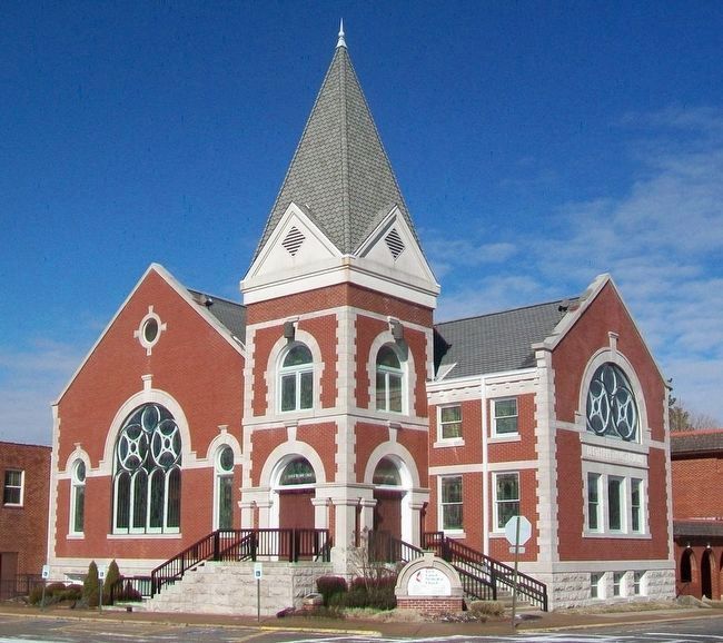
This building is a pinnacle of A.O. Clarke's interweaving use of limestone and brick, Romanesque arches, and stained glass window detail. In 1996, the historic sanctuary was renovated and is one of the highlights of the church. The trademark steeple . . . — — Map (db m93331) HM
This building constructed in 1918-19 cost a total of $75,000 including the site, furnishings, and fixtures. Listed on the National Register of Historic Places, it served as the U.S. Post Office for Rogers for over four decades. These 1918 . . . — — Map (db m90744) HM
1.6 acres for the
purpose of establishing
a church & cemetery.
Donated by L.E. Mason
& Ann Mason (wife)
Deeded July 20, 1861.
Trustees;
Thomas Bingham
Samuel H. Johnson
John Mason — — Map (db m224875) HM
To commemorate the Centennial passage, through Benton County of the First Westbound Stage coach on the Butterfield Overland Mail Route from St. Louis to San Francisco. Callahan's Tavern, the site of which is about a half a mile northeast of this . . . — — Map (db m216324) HM
Peter Van Winkle’s saw mill cut lumber for Confederate soldiers’ winter quarters at Cross Hollow and Oxford Bend in early 1862. Gen. Earl Van Dorn’s Confederates used the mill to grind corn after their March 1862 defeat at Pea Ridge, and wounded men . . . — — Map (db m90738) HM
The Rogers Victory Theater
Opened Monday, December 5, 1927, to a packed crowd of 750.
First Production: "American Beauty"
Notable Performers Over the Years:
Will Rogers, Conway Twitty
Designed by A.O. Clarke
Built by John Myler
It . . . — — Map (db m90740) HM
In 1832, Sylvanus Blackburn left Tennessee with a wagon and four oxen, and came to the War Eagle River valley in Arkansas. He spent the winter building a log home and clearing the land of his homestead. He brought his wife from Tennessee the next . . . — — Map (db m50367) HM
The Ozark Arts and Crafts Fair was founded on War Eagle Mills Farm by Lester and Blanche Elliott and friends in October 1954 for the purpose of giving recognition to Ozark artists and craftsmen who work with their hands and hearts to preserve the . . . — — Map (db m52066) HM
For God and Country Dedicated as a memorial to all that served in the Armed Forces of the United States of America Past · Present · Future
Sponsored by Disabled American Veterans, The American Legion, Veterans of Foreign Wars, Citizens of . . . — — Map (db m220471) WM
Restoring the Twin Springs Park & Gardens
In January of 2003, the Siloam Springs Garden Restoration Club, an affiliate of the Arkansas State Federation of Garden Clubs, took on the task of restoring the Twin Springs Park historic garden. . . . — — Map (db m220476) HM
Founded in 1889 has been entered into the National Registry of Historical Places by the United States Department of the Interior on 7-8-99. — — Map (db m224982) HM
These stones from the foundation of a farm house at Breezy Point, one mile west of this spot, where the first Summer Institute of Linguistics (Camp Wycliffe) was held June-September 1934, stand here as a memorial to God's faithfulness. From that . . . — — Map (db m224973) HM
Sylvanus Blackburn came to the War Eagle in 1832. By 1838 he had a saw mill, a grist mill, and a house. Peter Van Winkle came about 1850. By 1860, this was a thriving crossroads. March 8, 1862, Generals Van Dorn and Price, retreating from the . . . — — Map (db m19492) HM
On Jan. 21, 1864, Sgt. Isaac T. Jones led 24 men of the 11th Missouri Cavalry Volunteers into north Arkansas to bring dispatches to other Missouri troops operating against bushwhackers in the region. Jones and his men were near Rolling Prairie on . . . — — Map (db m141611) HM
It was built in 1893 by William M. Duncan in true Queen Anne architecture.
Duncan was the son of a Pennsylvania Congressman. Duncan also built the
fabulous Basin Park Hotel in Eureka Springs. This gorgeous house has had
many prominent owners . . . — — Map (db m225301) HM
Near this spring, in September
1857, gathered a caravan of 150 men,
women and children, who here began
the ill-fated journey to California.
The entire party, with the exception
of seventeen small children, was
massacred at Mountain Meadows, . . . — — Map (db m225305) HM
"This monument perpetuates the memory of those who true to the instincts of their birth, faithful to the teachings of their fathers, constant in their love for the state, died in the performance of their duty, who have glorified a fallen cause by . . . — — Map (db m143894) WM
Boone County Men Served Both Armies
During the Civil War (1861-1865), most of Boone Co. was part of Carroll with a small part in Marion Co. Local men served in both armies. There was a lot of military activity. The "Joe Wright Guards", CSA, . . . — — Map (db m141558) HM
In Memory of
Spanish American War Veterans
1898 - 1902
Erected by
Department of Arkansas Auxiliary
1941
Nelson S. Thornton - Ruby H. Lyons — — Map (db m143896) WM
Dedicated to the men and women of Boone County
who served with honor and glory and to those
inscribed here who made the supreme sacrifice
that we might live in freedom
World War I
Allen, Roy · Lafferty. Robert L.
Casey. John · . . . — — Map (db m143898) HM
This building, made up of two parts, has had a variety
of businesses including Capitol Café (the owners lived
upstairs), Oklahoma Tire, Bee Discount, Rowlands
Store, Fashion Lane and Unlimited Outlet. It is now
Beautiful You and Harness Boots . . . — — Map (db m225285) HM
Built in the early 1930s by Phillips Petroleum, it was the city's first full-service garage. West of the gas station, it was brick with a wood-framed vaulted ceiling. It was leased to "Hoot" Gipson who operated an auto repair shop and 24-hour . . . — — Map (db m141852) HM
One of the city's earliest gas stations, built in 1927 by W.H. Lewis, it was purchased in 1929 by Independent Oil (became Phillips 66). They remodeled it from a frame structure with rubblestone veneer to Tudor Revival Style. Independent . . . — — Map (db m141850) HM
In memory and honor of Jack Williams Pharmacist's Mate 3rd Class, USNR (October 18, 1924 - March 3, 1945) Recipient of Congressional Medal of Honor for conspicuous gallantry and intrepidity at the risk of his life above and beyond the . . . — — Map (db m229642) HM WM
In early September, 1857, the train arrived in a valley known as Mountain Meadows in southwestern Utah. Beginning early on the morning of September 7, the emigrants' camp was attacked by a group of Mormon militiamen and some Paiute Indians whom the . . . — — Map (db m225250) HM
Modern historical research has yielded information which was not readily available to those who designed the 1955 monument. Here is presented updated information and a modified more accurate map of the emigrants' route. Dedicated . . . — — Map (db m225248) HM
In memory of those who were killed in the Mountain Meadows Massacre, in September of 1857. Dedicated in 2020.
Modern historical research has yielded information which was not readily available to those who designed the 1955 monument. . . . — — Map (db m225251) HM
It is the former location of Hammerschmidt Lumber Co. and the First National Bank. It is now home of the Harrison flood of May 1961 mural (located inside) hand painted by Louis Fruend. This historic event commanded both national and international . . . — — Map (db m141869) HM
lt is one of the town's oldest commercial buildings and was built in 1876.
The original building was a two story wooden structure and was replaced
after the tum of the century with a one story rock building The facade has
been updated several . . . — — Map (db m141821) HM
The hotel opened on October 5, 1929 and was erected at a cost of $135,000. The Spanish Moorish design is built of brick, cement & steel making it virtually fire proof. Scaracenic Arches mark the front entries The Seville served for years as . . . — — Map (db m141854) HM
HH Jackson opened the Lyric in 1913 as the first indoor theatre in Harrison.
In 1918 Ed & Lulu (Garvin) Fitton purchased the business which featured
silent films until the “New Lyric” opened on the North side of the square
in 1929. At that time . . . — — Map (db m225284) HM
It was originally operated as a silent movie theater located on the West side of the square and owned by DE & Lulu Fitton. In 1929 JW Bass built a state of the art theater for talkies, leasing it back to the Fittons as the "New" Lyric. A mix of . . . — — Map (db m141840) HM
It was located above Jim Dye's Drug Store, currently Sam Alexander's Drug Store. The building was constructed in 1913 for the railroad offices and the city paid $35,000 to have them moved from Leslie. The M&NA was crucial to the economic development . . . — — Map (db m141868) HM
It was built in 1929 and was occupied by Ward's for 50 years. Notice the attractive facade that was added featuring the Goddess of Liberty and adopted as the corporate symbol. Fraley's Furniture and Appliances currently occupies the building. In . . . — — Map (db m225269) HM
In memory of 140 men, women and children N.W. Arkansas emigrants to California. In 1857 under leadership of Alexander Fancher (Piney Alex) left from Caravan Spring 4 miles south of here around May 1st - Camped at Mountain Meadows, Utah in early . . . — — Map (db m143889) HM
116 N. Willow, constructed in the early 20s, served
Harrison as a town store. ‘Spike’ and Katherine
Cavender, and son, Steve, operated The Well-Worth
Dime Store during the 50s. The store was destroyed
by the Crooked Creek flood on May 7, 1961. . . . — — Map (db m225272) HM
It was completed in 1903 and served as the Post Office from 1906 - 1965. The three story (plus basement) building was constructed at an original cost of $78,000 with a floor space in excess of 20,000 sq ft. It was constructed of hard-burned, dark . . . — — Map (db m141866) HM
Designed by architect Harry C. Schwebke & built by R.D. Pollard, the
Romanesque style brick building was the first free 4 year high school in
Boone County. Opening in 1912 the school served as a high school until 1952
when it became the junior . . . — — Map (db m225288) HM
It was constructed shortly after 1900. Henry Starr, a well known outlaw & nephew of Belle Starr, attempted to rob the bank here in 1921. He was shot & killed by JW Myers, a former bank president, with a rifle hidden inside the vault. It was recorded . . . — — Map (db m141629) HM
It was constructed in 1912. It originally housed Walter's Dry Goods on
the ground level & Fountaine Hall located upstairs. The Hall hosted the
Masons and also a play house of questionable character. The building is
located on what is known as . . . — — Map (db m225287) HM
The first temporary court house in Bradley County was erected on this site in 1842, two years after the creation of the county, and continued in use until 1858, when a court house built of brick was erected. — — Map (db m121054) HM
Though sparsely populated, Calhoun County raised five companies of soldiers for service in the Confederate army: Company B, Sixth Arkansas Infantry, Companies E and G, Second Arkansas Cavalry, and Companies A and K, Fourth Arkansas Infantry . . . — — Map (db m200670) HM
In early April 1857, a large wagon train known as the Fancher-Baker train left Caravan Spring (south of Harrison) and headed for California. They camped at this site en route to intercept the Cherokee trail at the Grand Saline in Indian territory. . . . — — Map (db m225245) HM
Both U.S. and C.S. troops rendezvoused in Berryville during the Civil War. By 1865, most of the town was in ruins. U.S. units were stationed here in 1863-64, including the 1st and 2nd Arkansas Cavalry, 6th and 8th Missouri State Militia, and Gaddy's . . . — — Map (db m168287) HM
The first court house in Carroll County. Built about 1825, was constructed of logs and stood on the site of Carrollton. A second court house was built of brick, but burned in 1859. Another court house was built of brick on the same site after the . . . — — Map (db m170746) HM
That we not forget
the cost of freedom,
let us honor
those who served,
and give thanks
for their sacrifice.
World War I
Rex Eldridge • Robert K. Grogan • Rosco Jordon
Korean Conflict
Herman Binam
Vietnam
George . . . — — Map (db m225239) WM
Settled 1833, was on the much-traveled Carrollton-Forsyth-Springfield road during the Civil War. A training center for Southern troops, it was important in movement of troops and supplies. Guerrilla warfare ravaged the area.
Skirmishes occurred . . . — — Map (db m141597) HM
Professor KALKLOSCH’s Guidebook, published in 1880, states: “The first street of the town was surveyed down the gulch below the spring. A broad avenue connects this street with the famous EUREKA BASIN SPRING. It being the first street it . . . — — Map (db m79755) HM
The 1st Arkansas Cavalry (U.S.), comprised mainly of Unionist refugees, mustered into service in July 1862. The regiment fought at Prairie Grove in 1862 and Fayetteville in 1863, but its main duty was fighting the bushwhackers and irregular . . . — — Map (db m225158) HM
The buildings, the bluffs, the spring and The Boulevard all make this a special place in Eureka Springs which has kept a peaceful beauty of earlier times.
The front of the McLaughlin Block has changed little since it was built in 1900 to . . . — — Map (db m80138) HM
Resort home built 1899 by William Henry Reid of Chicago. Architect Theodore C. Link of St. Louis. Design reflects simplicity favored at end of Victorian era. Upper floors are wood with verandas on four sides. Lower floor is Beaver Limestone. In . . . — — Map (db m80118) HM
Bank of Eureka Springs was established in May, 1912, in the Klock and Clark Building at 75 Spring Street. In 1946 it was relocated to 40 Spring Street.
In 1966, the bank purchased the McGinnis property at 70 South Main Street. The old livery . . . — — Map (db m90573) HM
Ellis Murphy established Murphy's Firestone Tire Service at this site about 1923. Called "Murphy the Tire Man", his services were frequently required to patch inner tubes and repair tires for hundred[s] of automobiles bringing tourists to Eureka . . . — — Map (db m90706) HM
This stone "Beaver Spring" house
was built circa 1912. It replaced
a log house built over the spring
purportedly by Wilson A. Beaver.
Beaver purchased the land in
1857 from John Williams who
homesteaded the land in 1852.
The Indians & . . . — — Map (db m225151) HM
This property has been
placed on the
National Register
of Historic Places
by the United States
Department of the Interior
Bridgeford House
1884 — — Map (db m225190) HM
Calif Spring was originally called Table Rock Spring, named for the rock formation above the spring area. This area was set aside as a spring reservation in 1886 by City Ordinance. S. L. Calif established a residence and general store next to the . . . — — Map (db m90703) HM
This is one of only four free public libraries in Arkansas funded by philanthropist Andrew Carnegie. It was built of native limestone and completed in 1912 on this site which was donated by Eureka Springs resident Richard C. Kerens. The architect . . . — — Map (db m80137) HM
Richard H. James and Charles S. Beck built the three story brick and limestone Beck and James Building in the year 1888 to house a clothing and apparel store.
F. H. and Avarilla James and their family resided in the upper rooms and C. S. Beck . . . — — Map (db m79738) HM
Ornate brick and limestone structure built after Great Fire of 1888 for Citizen's Bank established 1887 by J.T. Waddell. The bank failed in 1907. First National Bank occupied building until 1931 when it failed due to Great Depression. Bank of Eureka . . . — — Map (db m79736) HM
The Eureka Springs area's reputation as a health resort has its origins in the Civil War. Late 19th-century accounts claim Dr. Alvah Jackson treated sick and wounded soldiers during the war. In early 1865, Maj. J. W. Cooper, who led Confederate . . . — — Map (db m59967) HM
Crescent Cottage
on the National Register of Historic Places
Built in 1881
Home of Powell Clayton,
the first governor of Arkansas
after the state was readmitted
to the Union following
the War Between the States
Owners
Ray & . . . — — Map (db m80139) HM
Crescent Spring was revered for its healing waters almost as much as the basin, the legendary Indian Healing Spring. Situated beside the Wagon Road on a hillside with a rocky outcropping described as "crescent" shaped, the spring was soon given . . . — — Map (db m80135) HM
Eastview is situated adjacent to Harding Spring on a lot originally registered by Absalom M. Thomas after the town site survey of 1879. John E. and Bell Perrin purchased the lot and residence in October, 1881, then sold to David R. and Harriett . . . — — Map (db m80140) HM
Built in 1883 by Ellar Elwood.
After townsite established by
federal court decree, deed received
June 15, 1885, by T. Elwood Clark.
The three-story wood trimmed
brick structure, shown on 1886 map
as a boarding house and residence,
escaped the . . . — — Map (db m225182) HM
This three-story limestone building with metal-clad roof enclosing the top story was constructed in 1889 by Samuel L. Calif. For fifty years it served as a residence, general merchandise store, and boarding house. About 1948 the building was . . . — — Map (db m90699) HM
North Main Street was a busy area dedicated to the basic necessities of life in early Eureka Springs: mills, wagon yards, feed stores, blacksmiths, stables, small groceries, rags and old iron with the occasional manufacturer of soap, brooms, yeast, . . . — — Map (db m225177) HM
The neighborhood above the current First Baptist Church burned in the Great Fire of 1883, the first of four Great Fires which destroyed most of the town's early wooden structures. New commercial buildings were built of more fire-resistant . . . — — Map (db m131739) HM
The words "esto perpetua" emblazoned upon a stone above the entrance to Grotto Spring declare the prevailing belief that these healing waters would flow forth forever. Early townspeople discovered the spring under an overhanging rock ledge, a . . . — — Map (db m80121) HM
Named for J. Emmett Harding, a photographer who began the tradition of making photographs of people in front of the spring as souvenirs. He built a small dwelling near the spring in the summer of 1879.
In 1879, the spring was accessed by a . . . — — Map (db m80151) HM
Kentucky House Hotel established on this site 1880, Mrs. E.D. Andrews, proprietor. Building survived Great Fire 1888, disappeared by 1900. Street work 1915 created stone wall. Sharp’s Continental Oil Company gas station constructed 1928. Epley and . . . — — Map (db m79756) HM
The site of this spring was outside the area included in the 1879 survey. Known as East Mountain, this area was crowded with wood structures by 1885. The spring, which flowed from a small cave lined with projections of onyx stone, was already . . . — — Map (db m80152) HM
Festus Orestes Butt was born in 1875 in Illinois just before his family moved to Carroll County, Arkansas. He became a licensed attorney before he was of legal age. The Arkansas General Assembly set aside his "disability of minority", and he set up . . . — — Map (db m79735) HM
Any metal object placed in the spring
water was widely claimed to become
magnetized. It was also claimed that
exclusive use of the water from
Magnetic Spring would cure physical
debility and aid in overcoming drug
addiction. Drug addiction . . . — — Map (db m225223) HM
"It being the first street in town... it was named Main Street. But owing to its low elevation and the law of gravitation, the water would find a level in the street, and as the immense travel created an abundance of mud, the street was nicknamed . . . — — Map (db m80153) HM
Built in Berlin, Germany 1934, 600 millimeter gauge (24 inch) (same engines are used at Silver Dollar City). Engine was found near Orlando, Fla. in 1989. Was bought by gentleman from Switzerland and hauled to Eureka Springs same year. Plans are to . . . — — Map (db m80172) HM
This spring derived its name from early townspeople who declared the water to have a pleasant, sweet taste. The spring was originally located in the deep ravine below the present site. A long wooden stairway led from the spring to the narrow . . . — — Map (db m80115) HM
Sweet Spring Hotel
The Sweet Spring Hotel was established about 1887 at the corner of Pine Street and Spring, then known as Rice Street, with A.S. Capps as proprietor. The spacious three-story frame structure was painted white with dark . . . — — Map (db m80112) HM
Basin Bath House was established 1879 adjacent to Basin Spring by Dr. Alvah Jackson's son, Thomas. John S. Tibbs succeeded Jackson about 1880, operated bath house and Eureka Water Shipping Company. Building was destroyed by Great Fire of 1888, . . . — — Map (db m59969) HM
I stood here growing so many years,
I shared your laughter, I shared your tears.
My life was good, beginning to end,
and this is a wish I'd like to send.
Be happy and kind to all around,
and let not sorrow be ever found.
The spirit of . . . — — Map (db m59971) HM
• Between 1945-1961 2.7 million escaped East Germany
• In 1960, 200,000 East Germans escaped to Freedom
• Order given to build Wall - Sunday, Aug. 13, 1961
Construction began Aug. 16, 1961; completed 2 mos. later
• Initially 6 ft. . . . — — Map (db m80171) HM
These two large limestone public buildings anchor this part of downtown Eureka Springs. They span the deep ravine cut by Leatherwood Creek which flows in a tunnel beneath all the buildings on this entire part of Main Street.
[Photo 1.]
This . . . — — Map (db m59964) HM
May 20, 1886...
America's newest and most luxurious hotel built at a cost of $294,000.
It was two years ago that Powell Clayton and his associates chose the site of the new Crescent Hotel... twenty seven acres at the north end of West . . . — — Map (db m80116) HM
Pioneer burial ground on land homesteaded 1880 by James and Rachael McAtee Lamar. Recorded burials begin 1880 after founding of Eureka Springs. May 29, 1889, the 46-acre site deeded to Lodge No. 83 Independent Order of Odd Fellows which maintained . . . — — Map (db m225226) HM
On this part of Spring Street you can easily see how Eureka Springs follows the natural lines of the landscape. Houses are built right into the bluff on the west side and buildings climb down the steep hillside on the other side. “The houses rise . . . — — Map (db m225187) HM
1884 - Cutter's Guide
The Eureka Springs of Arkansas
The hotels and boarding houses of Eureka Springs are numerous. The Perry House is the only real first-class hotel in the city; and we say this with no disparagement of the . . . — — Map (db m79733) HM
1713 entries matched your criteria. Entries 201 through 300 are listed above. ⊲ Previous 100 — Next 100 ⊳