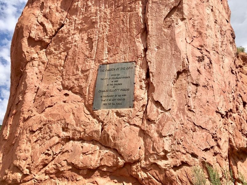
Given to
the City of Colorado Springs
in 1909
by the children
of
Charles Elliott Perkins
In fulfilment of his wish
that it be kept forever
free to the public — — Map (db m135023) HM
This rock formation, called Sentinel Rock, is a geologic treasure. It is composed of two types of rock - a fine sandstone and a gravelly conglomerate. The various layers in this rock were deposited 275 million years ago. During that time, ancient . . . — — Map (db m135022) HM
Lt. Zubulon M. Pike and his men, who traveled through this area in November and December 1806, were the first American explorers to view the Arkansas River Canyon now known as the Royal Gorge. A small party from the Maj. Stephen H. Long expedition . . . — — Map (db m34858) HM
From Vision to Reality
Glenwood Canyon has been a critical link in the nation's ground transportation network ever since the completion of the Denver & Rio Grande Railroad in 1887. Later, Taylor State Road, a continuous wagon road between . . . — — Map (db m120263) HM
The Vision
The year was 1886. Walter Devereux, a wealthy silver mining venture capitalist from Aspen, turned his vision downvalley to Glenwood Springs to develop the next world
class resort. The area's climate, rich land, rivers and free . . . — — Map (db m120130) HM
In 1905, Colorado state senator Edward T. Taylor said, "I hope that someday our road will be a portion of a grand boulevard stretching across the nation." Taylor referred to the 12.5-mile gorge known as Glenwood Canyon. Today, the canyon road is the . . . — — Map (db m120136) HM
Glenwood Canyon inspired the finest hour in American rail travel. During World War II a railroad official rode through here in the cab of a diesel freight locomotive. The view from the panoramic windshield so impressed him that he began steps to rig . . . — — Map (db m120140) HM
The Dillon Pinnacles are one example of many spires found within Curecanti. Pinnacles are a product of erosion. Wind, rain, and ice are carving away at the landscape. This process happens everywhere, so why does the rock here form pinnacle shapes? . . . — — Map (db m158868) HM
Here, in the shadow of the Spanish Peaks and the Wet Mountains, stands El Huerfano - "the orphan." This stark and lonely volcanic outcrop, named in the late 1700s by an unknown Spanish trader, had for centuries guided earlier Hispanos and . . . — — Map (db m97717) HM
Clear Creek is one of the most popular and historic waterways of the Front Range. The Clear Creek watershed covers approximately 1550 square kilometers (600 square miles), includes five counties, and more than thirteen communities. From the . . . — — Map (db m49896) HM
The history of Golden reflects the history of Clear Creek. Eons ago, this creek, then a raging river, coursed its way through the mountains, cutting out the canyon and leaving behind fertile soil where an abundance of plants provided food for wild . . . — — Map (db m49908) HM
This is part of the Morrison Formation accumulated around 150 million
years ago. Monsoonal (seasonal) rains caused flooding which dotted the terrain
with small lakes, ponds, and braided streams. These served as watering holes
in the drier times. . . . — — Map (db m125152) HM
Mountain-building processes generate massive pressures in
the earth’s crust. Such pressures cause the rock layers to tilt, buckle,
or fold and sometimes to break or crack. In addition to the obvious tilting of rocks
along the Dakota Hogback, . . . — — Map (db m125154) HM
The high mountains west of here are the beginning of the Rocky Mountains.
They are made up of resistant Precambrian granite and gneiss. The prominent red rocks
in Red Rocks Park are the Fountain Formation, a series of sandstones and . . . — — Map (db m125055) HM
A volcano erupted hundreds of miles from here and ash from the volcano
blanketed this area, which was a swampy environment. Subsequent burial,
compaction, and chemical alteration led to this four inch white to rusty orange
colored claystone . . . — — Map (db m125321) HM
•Colorado’s geologic history dates back nearly two billion years. Several mountain ranges have been uplifted and eroded away before the rise of today’s Rocky Mountains. The landscape you see in front of you has undergone many dramatic changes. This . . . — — Map (db m46438) HM
•This diagram illustrates the features you can see from here. North and South table Mountains are remnants of ancient lava flows now separated and eroded by Clear Creek. The Dakota Hogbacks on the left and right sides of the image were one . . . — — Map (db m46439) HM
You are looking out over the edges of tilted and eroded layers of sandstone and shale that lie upon much older rocks in the mountains behind you. If the eroded layers were restored to where you stand they would be more than two miles thick. The . . . — — Map (db m57932) HM
The "great divide" separates drainage to the Atlantic
from drainage to the Pacific. It traverses America from
Alaska almost to Cape Horn.
Atlantic Ocean
«« drainage
Cache La Poudre Creek
drains into the Platte River
which flows to . . . — — Map (db m89106) HM
Panel 1
Welcome to Colorado
Colorado's vast plains, rugged mountains and grand plateaus, so magnificent in their beauty and variety seem at times to overshadow the state's history and people. But look closely. The . . . — — Map (db m97739) HM
The rocks that make up this landscape formed in environments that are very similar to ones we can observe on the earth's surface today as well as ones that occur beneath the surface where tectonic plates collide to form mountain ranges.
Kayenta . . . — — Map (db m159711) HM
While this might look like a glacial U-shaped valley, it is not. It is a canyon formed by flowing water. The story is one of different rocks responding to erosion in different ways.
Hanging Canyon
Notice how the profile of this canyon . . . — — Map (db m159762) HM
Take the short stroll to a spectacular and unique viewpoint to discover more about the Monument's geology and high flying birds.
Bird Habitat
The airspace above the protected canyons is the domain for a diverse variety of birds.
The Oldest . . . — — Map (db m159709) HM
Erosion produces unusual shapes on the landscape. As the protective Kayenta Formation layers erode from the ridge before you, the softer Wingate Formation beneath it is exposed and responds in a unique way. Early visitors throught these shapes . . . — — Map (db m159759) HM
Water! Every drop has a destiny via the continent’s backbone: the Continental Divide.
With a foot on each side of the bronze line below, you are symbolically straddling the spine of the Western Hemisphere. In North America the Divide follows . . . — — Map (db m71660)
Over a billion years ago, molten rock was squeezed into fissures forming the light-colored bands which thread Black Canyon's otherwise dark walls. You are standing on one of these bands. As the hot fluid slowly cooled and hardened, minerals formed . . . — — Map (db m158993) HM
At 2300 feet, Painted Wall is the highest cliff in Colorado. If the Empire State Building stood on the canyon floor, it would reach slightly more than halfway to the top of the cliff.
The patterns that inspired the name Painted Wall were created . . . — — Map (db m159001) HM
It took bold men to ride into a bold land—a land of raging rivers,
burning deserts, towering mountains, and rugged canyons.
The land of the Southwest through which Dominguez and
Escalante travelled in 1776 was awesome in beauty and . . . — — Map (db m120226) HM
You are standing at the Ouray Fault, the first step in the formation of Box Cañon Falls. Millions of years ago a deep crack in the earth caused the harder rocks to move upward, while the soft sedimentary rocks to the north moved downward. As you . . . — — Map (db m191376) HM
In front of you is one of the largest fossils in the park, a massive petrified redwood stump. The Big Stump is all that remains of a redwood tree that may have been more than 230 feet (70 meters) tall and 500-1,000 years old when the lahar buried . . . — — Map (db m240556) HM
Explosive volcanic eruptions, a quiet freshwater lake, towering redwoods. A picture of this valley 35 million years ago is revealed by studying the rocks that are here today. — — Map (db m93087) HM
Florissant Fossil Beds National Monument safeguards a buried treasure: one of the world's richest fossil deposits. Look around. This 6,000 acre open space belongs to all of us—and to future generations. But what if instead of a public resource, it . . . — — Map (db m240551) HM
On these widespread plains blown clean by the wind and rains large herds of buffalo roamed and gained in number. Then the warriors of Indian tribes hunted them for food and skins. Later white men came to trap beaver in the prairie channels and the . . . — — Map (db m119615) HM
Status: Threatened
Formerly an endangered species due to poaching, their population has increased thanks to environmental awareness programs at zoos like Connecticut's Beardsley Zoo.
In the past, the shallow and stagnant Mill Pond was not a good place for marine life. In 1996-97, the City of Norwalk undertook a $500,000 project to improve the aquatic habitat. Funds for the work came from the Connecticut Department of . . . — — Map (db m53485) HM
Stone Walls
as increased farming began to change Litchfield's landscape, farmers discovered large deposits of granite and gneiss rocks in the ground. The farmers dug up and hauled away these stones as the land was cleared for crops and . . . — — Map (db m230289) HM
Highlights of Lover’s Leap State Park
New Milford, CT
Lover’s Leap State Park is located in southern New Milford. The Housatonic River flows through the park and forms the headwaters of Lake Lillinonah. This historic 140 acre park began in . . . — — Map (db m22739) HM
Ever since Adrian Block's discovery of the Connecticut River in 1614, the extensive bar at its mouth has been an obstacle for mariners, preventing vessels of deep draft from entering. The runoff from the source of the river in Canada traveling . . . — — Map (db m182715) HM
Ever Since Adrian Block's discovery of the Connecticut River in 1614, the elusive bar at its mouth has been an obstacle to mariner, preventing vessels of deep draft from entering. The runoff from the source of the river in Canada . . . — — Map (db m227281) HM
Fort Delaware is located on Pea Patch Island in the Delaware River. The island is sometimes said to have gotten its name from a boat loaded with peas that ran aground on a mud shoal in the 1770s. The spilled peas sprouted, mud caught in the . . . — — Map (db m21589) HM
From Pencader Hundred shipping was possible by either the Delaware River of the Chesapeake Bay.
One third of the population of the United States now lives within a day's drive of Pencader Hundred.
The shortest distance overland between . . . — — Map (db m238426) HM
From Pencader Hundred shipping was possible by either the Delaware River of the Chesapeake Bay.
One third of the population of the United States now lives within a day's drive of Pencader Hundred.
The shortest distance overland between . . . — — Map (db m238420) HM
A geological oddity
Many people call the huge rocks you see along this trail "blue granite" or "blue rock." This is because when they are broken, the fresh exposed rock is a brilliant blue color. Continued exposure to air soon gives them . . . — — Map (db m240819) HM
The highest bench mark monument in Delaware is located on Ebright Road. This horizontal control mark denotes an elevation of 447.85 feet above sea level. The Delaware Geological Society through its relationship with the National Geodetic Survey has . . . — — Map (db m128088) HM
The Indian River Inlet has not always existed in its current location. This barrier beach environment is dynamic, and the opening to the inlet has opened and closed at different locations.
When the inlet closed, navigation, water quality, . . . — — Map (db m206345) HM
The Indian River Inlet has not always existed in its current location. This barrier beach environment is dynamic, and the opening to the inlet has opened and closed at different locations.
When the inlet closed, navigation, water quality, . . . — — Map (db m150130) HM
There is a river that flows from Andean slope in Peru at 4,886 meters above sea level down to the Pacific Ocean. The river travels 388 kilometers and its sections are called Pacco Pacco, Chilimayo, Colca, Majes, and Camana. Along the section of . . . — — Map (db m190140) HM
The first woman to reach the summit of the most dangerous mountain in the world - K2. The first European woman to conquer Mount Everest. One of the greatest climbers in history.
At the top of Mount Everest she left a small stone brought . . . — — Map (db m200429) HM
Used as a signal station
· by ·
Confederate soldiers under
Gen. Jubal A. Early
during the attack on
· Washington ·
July 11 and 12, 1864
Also used by
Confederate Sharpshooters
The lower plaque reads:
Two cannon balls . . . — — Map (db m42698) WM
You are standing on what remains of Rock Creek's Piney Branch stream valley. The valley was once a forested, 2,500-acre network of springs, seeps, and wetlands that reached almost to Takoma Park, Maryland. Today, houses, apartment . . . — — Map (db m151242) HM
What Is a Meadow?
A meadow is more than just an open field. Meadows are diverse, dynamic habitats dominated by herbaceous plants, including native grasses and wildflowers.
Why Are Meadows Important?
Meadows provide cover, food, . . . — — Map (db m211404) HM
This stone is one of four Cardinal Direction Markers that honor the four directions—north, east, south, and west. Representatives of Native communities in Canada, Maryland, Chile, and Hawai'i selected a meaningful stone from their region. . . . — — Map (db m211259) HM
This stone is one of four Cardinal Direction Markers that honor the four directions—north, east, south, and west. Representatives of Native communities in Canada, Maryland, Chile, and Hawai'i selected a meaningful stone from their . . . — — Map (db m211257) HM
This stone is one of four Cardinal Direction Markers that honor the four directions—north, east, south, and west. Representatives of Native communities in Canada, Maryland, Chile, and Hawai'i selected a meaningful stone from their . . . — — Map (db m211256) HM
The Alachua Sink, a named likely derived from the Potano word meaning “jug,” is the deepest of Paynes Prairie’s sinkholes and acts as a conduit for water entering the Floridan aquifer at a rate of up to 6 million gallons per day. . . . — — Map (db m126294) HM
Devil’s Millhopper
has been designated a
Registered Natural Landmark
This site possesses exceptional value
as an illustration of the Nation’s natural
heritage and contributes to a better
understanding of man’s environment
. . . — — Map (db m125200) HM
Ichetucknee Springs
Has been designated a
Registered Natural Landmark
under the provisions of the
Historic Sites Act of August 21, 1955
this site possesses exceptional value
in illustrating the natural history of the United . . . — — Map (db m126019) HM
500 Spanish soldiers from St. Augustine marched four days through marsh, forest tangle, fierce wind, and heavy rainfall to an encampment near here. Exhausted and hungry they rested in a downpour; at dawn they attacked and captured France's Fort . . . — — Map (db m46579) HM
Bound by the Nassau River, the Atlantic Ocean, and the St. Johns River, the Timucuan Ecological and Historic Preserve seeks to protect much of the water and undeveloped land you see from here. Salt marsh, coastal hammock, tidal creeks, and sea and . . . — — Map (db m46576) HM
If you flew over Pensacola Bay, you would see that it has many natural forms of protection. Sandy barrier islands defend the narrow entrance into the bay and rolling hills provide excellent vantage points to watch ships arrive. The many colonial . . . — — Map (db m130741) HM
In this area, the St. Marks River disappears into sinkholes several times and reappears as springs. Here, it flows underground through a cavern and reappears 150 feet to your right. This has formed a land bridge which has been used by wild . . . — — Map (db m157204) HM
Rainbow Springs has been designated a Registered Natural Landmark
Under the provisions of the Historic Sites Act of August 21, 1935
This site possesses exceptional value in illustrating the natural history of the United States
U.S. . . . — — Map (db m13618) HM
The Tamiami Trail was crucial to opening up the wilderness and creating a link to Florida's major cities. Building a road through the heart of the Everglades was no easy task, but with the power of human ingenuity the builders were able to . . . — — Map (db m132100) HM
On this spot of land at the mouth of the Miami River, a historic discovery shed new light on one of Florida's early peoples - the Tequesta. During the demolition of the Brickell Point apartments in 1998, archaeologists uncovered preshistoric . . . — — Map (db m65644) HM
Over the past several million years, the seas have risen and fallen many times. There were times when Florida became very small and even disappeared due to being covered by water. What we know as Florida is only the top of a larger area, known as . . . — — Map (db m225802) HM
The B-57 is a modified version of the English Electric Canberra which was first flown in Britain on May 13, 1949. In March 1951 the USAF contracted the Glenn L. Martin Co. to build the B-57 in the US under a licensing agreement with Britain. The . . . — — Map (db m102699) HM WM
To the memory of Dr. Howard Atwood Kelly of Baltimore, Maryland, one of the founders of Johns Hopkins Hospital and medical school. He was a great surgeon, teacher and medical authority, and above all, a Christian gentleman.
Dr. Kelly, in 1927 . . . — — Map (db m66834) HM
Rock Springs is the source of the Rock Springs Run, a swift running stream with an average flow of 26,000 gallons per minute and a constant temperature of 68 degrees. The spring flows from limestone containing fossils that date back 17 million . . . — — Map (db m94341) HM
In the 1880's, and before, when settlements in Osceola County were just beginning, there were few roads as such, mainly wagon trails and no bridges over Single Creek. The road west, Vine Street led to three Fords named after Jim Yates (also called . . . — — Map (db m204486) HM
This petrified wood is over 80000,000 years old. The trees originally grew in the Triassic Period. After the tree died, it was buried by sediment and saturated with water rich in silica, Eventually the makeup of the wood was replaced by silica and . . . — — Map (db m237650) HM
Historic Kissengen Spring is located approximately one mile north of this location. At one time the spring discharged up to 20 million gallons of water a day into the Peace River. The spring’s pool was 200 feet in diameter and reached a depth of 17 . . . — — Map (db m67655) HM
By the turn of the twentieth century, Simpson and Company was shipping lumber as far away as Scandinavia. Following the deaths of the partners in the Simpson Company the lumber mill was sold in 1903 to Thomas R. Lyon of Chicago, who renamed it . . . — — Map (db m100331) HM
Submerged aquatic vegetation is an important part of the Northwest Florida ecosystem. It is defined as any combination of seagrasses and algae that covers 10 to 100 percent of the riverbottom. Many of these plant species grow in underwater . . . — — Map (db m100329) HM
About 200 yards south-east of this point are the remains of the King's Coquina Quarries. (Coquina, a type of limestone composed of mollusk shells and sand, is found along the north-east coast of Florida.) Coquina was used in the building of many . . . — — Map (db m28361) HM
Park development started in 1963 on this hill, which has an elevation of 322 feet and a limestone base. A stream flowing from the hill plunges over a cliff and disappears through an underground channel. Some sinks and caverns are near the falls, . . . — — Map (db m73295) HM
Throughout history our rivers have been used and abused. Conservation enhances the valuable uses of our river, and protects the plant and animals of our river community.
Our rivers are brown because of poor farming and construction practices . . . — — Map (db m207646) HM
This ridge, interrupted only by major streams, extends south from the Altamaha River in Georgia to the Santa Fe River in Florida, a distance of 130 miles. It is an ancient barrier beach formerly many miles off-shore in the sea which covered this . . . — — Map (db m12423) HM
The wonderful healing powers of the waters of Indian Spring were known to the Indians before the pioneers blazed the trail of civilization in Georgia. Such were their belief and confidence in the medicinal virtues of the waters that they came with . . . — — Map (db m404) HM
The road E. ascends Taylor’s Ridge & via Nickajack Gap, crosses E. Chickamauga Cr. Valley. May 7, 1864. Brig. Gen. Judson Kilpatrick’s (3d) Div., Elliott’s Cav. Corps (Army of the Cumberland) [US], moving from Ringgold, crossed Taylor’s Ridge at . . . — — Map (db m19394) HM
The origin of both this lake and its name are a mystery as the source of water is unknown and analysis has shown no lime in the soil. The lake which reputedly “has no bottom” formerly served as a baptismal pool for the adjacent Salem . . . — — Map (db m40380) HM
This site is described in the treaty signed by the Creek and Cherokee Indians at Augusta, Georgia, in 1773. Here began the survey of the ceded lands. — — Map (db m15712) HM
This highway runs along the divide between the Atlantic Ocean and the Gulf of Mexico. On the south the waters run into the Broad and Savannah rivers to the Atlantic Ocean. Waters on the north run into Chattahoochee and Apalachicola rivers and the . . . — — Map (db m21065) HM
During the 21 years (1924–1945) in which he was a constant visitor to Warm Springs, Ga., Franklin D. Roosevelt became familiar with the scenic beauties of field & forest in the environs. The splendid isolation of Dowdell’s Knob, with its . . . — — Map (db m43137) HM
Pine Mountain to the south makes a complete loop forming a beautiful basin 4 miles in diameter known as `The Cove.` It is joined on the south by Oak Mountain, another hard quartz ridge. Flint River has avoided an easier course on either side and has . . . — — Map (db m9053) HM
Trickles of water running down old Indian paths to springs formed the Providence Canyons, natural wonders of the Southeast.
These canyons, named for an old church that had to be moved out of their path, are often called “Little Grand . . . — — Map (db m46392) HM
The sand clay formation here represents the first prominent Coastal Plain deposits laid upon an ancient floor of granites and gneisses. Southward this formation (Tuscaloosa Upper Cretaceous) becomes more and more deeply buried and contains marine . . . — — Map (db m27177) HM
The name is derived from the Cherokee word ltse’yi (New Green Place) or (Place of Fresh Green, from ltse’hi (green or unripe vegetation), and yi, the locative. It occurs in several places in the old Cherokee country, variously spelled Echia, Echoee, . . . — — Map (db m32706) HM
The high, rounded peak, Brasstown Bald or Mt. Enotah, is the highest mountain in Georgia, 4,748 ft. Its Indian name, Itseyi, means “a place of fresh green,” referring to its grassy, instead of timbered, summit. Early white settlers . . . — — Map (db m32729) HM
One and one tenth mile south-southeast from this marker is the geographic center of the state. The center is defined as the balance point of a plane or thin sheet of a uniform thickness in the shape of the area.
The central point is . . . — — Map (db m49532) HM
Blood Mountain, elevation 4458 ft. Chattahoochee National Forest. In Cherokee mythology the mountain was one of the homes of the Nunnehi or Immortals, the “People Who Live Anywhere,” a race of Spirit People who lived in great townhouses . . . — — Map (db m3259) HM
The high rounded peak to the south with lookout tower is Brasstown Bald or Mount Enotah, the highest mountain in Georgia 4,748 feet above sea level. Its Indian name, Itseyi, means “place of fresh green” and refers to its grassy instead . . . — — Map (db m32613) HM
The first obstacle facing the Federal Army in the September 1863 invasion of Walker County was getting over Lookout Mountain. Cooper's Gap, Stevens' Gap, and Dougherty's Gap proved to be serviceable. "Ascertaining that the rebels were just . . . — — Map (db m168059) HM
Jesse Stephens was a famer living at the base of the mountain. Although the Federal records usually misspelled his name as Stevens, the name of the gap and road are derived from him. The 1860 Federal Census shows him as a 54 year old Georgia native. . . . — — Map (db m168071) HM
Okefenokee Swamp, 400,000 acres of waterways, swamp prairies and floating islands is a region of many legends. Here DeSoto’s men told of trees that turned to warriors, Indians hunted and fished in its fastnesses and fled to safety on its islands . . . — — Map (db m53058) HM
This valley has long fascinated travelers, writers and artists. It was farmed for centuries by Indians and white men alike. The valley was devastated by Spanish and American gold hunters and timbermen and has been carefully nurtured by prosperous . . . — — Map (db m43706) HM
Otherwise known as Buzzard Roost. This natural gateway through Rock Face Ridge, was heavily fortified by Confederate forces at Dalton, after their
retreat from Missionary Ridge.
February 25, 1864, the Federal 14th A.C., Dept. of the Cumberland, . . . — — Map (db m11069) HM
Otherwise known as Buzzard Roost. This natural gateway through Rock Face Ridge was heavily fortified by Confederate forces at Dalton after their
retreat from Missionary Ridge. February 25, 1864, the Federal 14th A.C., Dept. of the Cumberland, . . . — — Map (db m11072) HM
South Point Complex has been designated a Registered National Historic Landmark under the provisions of the Historical Sites act of August 21st 1935. This site possesses exceptional value in commemorating and illustrating the history of United . . . — — Map (db m2314) HM
1802 entries matched your criteria. Entries 201 through 300 are listed above. ⊲ Previous 100 — Next 100 ⊳