265 entries match your criteria. Entries 101 through 200 are listed.⊲ Previous 100 — The final 65 ⊳
Idaho State Historical Society Historical Markers
Markers of the Idaho Highway Historical Marker Program administered by the Idaho State Historical Society in cooperation with the Idaho Transportation Department.
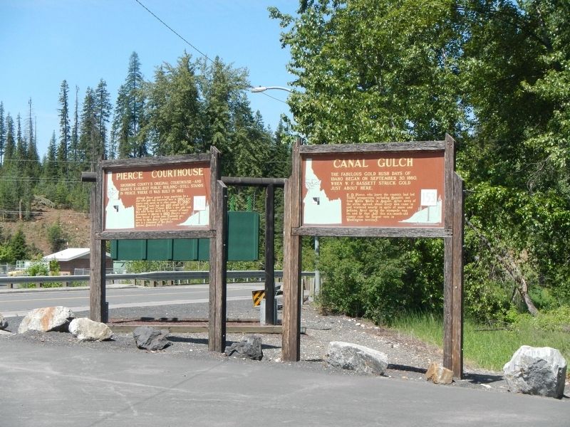
On Main Street (State Highway 11 at milepost 29) at Canal Street on Main Street.
Shoshone County's original courthouse -- and Idaho's earliest public building -- still stands in Pierce., where it was built in 1862.
Although Pierce gained a large population for a year after gold was discovered here in 1860, most of the . . . — — Map (db m121520) HM
On West Pierce Street (State Highway 11) near West 7th Street.
Journeying toward the Clearwater, 6 men under Clark met the Nez Perce Indians not far from here, September 20, 1805.
Clark first saw 3 frightened Indian boys who hid in the grass. Finding two, he reassured them with small presents and "Sent . . . — — Map (db m121439) HM
On State Highway 75 near U.S. 93, on the right when traveling south.
Before settlers came to Idaho in 1860, Buffalo used to roam through this valley. Most of them had left here by 1840.
After they acquired Spanish horses, eighteenth century Shoshone buffalo hunters could drive a small herd over a cliff to make . . . — — Map (db m109766) HM
On U.S. 93 at milepost 245.3,, 0.9 miles north of Idaho 75 Scenic (Idaho Highway 75), on the right when traveling north.
This Valley was discovered in 1822 by an expedition of Hudson's Bay Company trappers led by Michel Bourdon. Bourdon had come to the Northwest with David Thompson, who had started the Idaho fur trade in 1808-9. Trappers searched everywhere for . . . — — Map (db m59949) HM
On State Highway 75 at Kinnikinic Road, on the left when traveling west on State Highway 75.
Lead-silver mineral discoveries 12 miles north of here on Bayhorse Creek in 1864 and 1872 led Joel E. Clayton to locate a large smelter here in 1880.
Doubled in size in 1888, Clayton's smelter has enough variety of ores from local mines to . . . — — Map (db m110016) HM
On U.S. 93 at Doublespring Pass Road, on the right when traveling north on U.S. 93.
On October 28, 1983, a major earthquake fracture, 26 miles long and 7 miles deep, surfaced as Lost River Valley slid away from Mount Borah.
During that rock shift, Mount Borah’s ridge front rose about 6 inches, while this valley subsided 9 . . . — — Map (db m109704) HM
On Custer Street (U.S. 93) near Capital Avenue, on the right when traveling north.
Cliff City and White Knob were bustling mining towns established west of Mackay in the late 1800s.
After copper was discovered in the White Knob Mountains in 1879, Cliff City and White Knob sprang up to support the mines. The boomtowns . . . — — Map (db m140071) HM
On U.S. 93 at Fish Hatchery Road, on the left when traveling north on U.S. 93.
Known as Goddin's River in the days of the fur trade. This stream originally was named for the trapper who discovered it.
Thyery Goddin, a prominent Iroquois who explored this river in 1819 or 1820, had come here with Donald Mackenzies fur . . . — — Map (db m109705) HM
On U.S. 93 at Doublespring Pass Road, on the right when traveling north on U.S. 93.
Idaho’s highest peak, 12,662 feet, is named for William E. Borah, who served in the United States Senate from 1907 until his death in 1940.
Ten or a dozen large but shallow inland seas have covered this area in the past billion years. They . . . — — Map (db m109703) HM
On Custer Street (U.S. 93) near Capital Avenue, on the right when traveling north.
Mt. McCaleb, named for the Civil War veteran and local merchant, Jesse McCaleb, is the prominent 11,683 ft. peak visible north of MacKay.
In 1878, while helping escort supply wagons and arms to Challis, McCaleb and 13 others were attacked by . . . — — Map (db m140070) HM
On State Highway 75 at milepost 190 at Sawtooth Terra Tracts Road, on the right when traveling south on State Highway 75.
Long before miners and ranchers settled Stanley Basin, bears dominated this area.
When Alexander Ross and his Hudson’s Bay Company trappers stopped here, September 20, 1824, they “observed at some distance the appearance of a ploughed . . . — — Map (db m110042) HM
On Idaho Route 75 at milepost 190 at Sawtooth Terra Tracts Road, on the right when traveling south on State Route 75.
When Challis National Forest was established in 1908, this site became an administrative center. Early log Ranger Stations stood here from 1909 to 1932.
Expanding Forest Service responsibilities led to construction of a larger ranger . . . — — Map (db m182177) HM
On South Commerical Street at W. Madison Avenue, on the left when traveling south on South Commerical Street.
A perilous ford at Three Island State Park was a formidable Oregon Trail barrier. Those who could not cross here faced a longer, more difficult southern route. No other ford between Missouri and Oregon troubled them so much. This was their largest . . . — — Map (db m31677) HM
On Sun Valley Highway (U.S. 20 at milepost 124) near North Cat Creek Road, on the right when traveling west.
Up toward Camas Prairie, a road goes by Castle Rock and other eroded granite outcrops that were landmarks on Goodale's Cutoff, an Oregon Trail route that came this way.
Emigrants generally had not seen large granite rock formations of this . . . — — Map (db m110143) HM
On Sun Valley Highway (U.S. 20 at milepost 126) near Old Highway 68, on the left when traveling west.
More than a century ago, Rocky Bar, Happy Camp, and a number of other South Boise mining towns flourished in a remote mountain wilderness 30 miles northwest of here.
Discovered early in 1863, they were so hard to get to that the could not be . . . — — Map (db m110142) HM
On Sun Valley Highway (U.S. 20 at milepost 124) near North Cat Creek Road, on the right when traveling west.
An old emigrant road headed west across Camas Prairie and then descended to the valley below on its way to rejoin the Oregon Trail 28 miles west of here.
This route, discovered by Donald Mackenzie's fur trade party in 1820, came into use for . . . — — Map (db m125603) HM
On Sun Valley Highway (U.S. 20 at milepost 102.7) north of Industrial Way, on the left when traveling south.
At the junction of the Rocky Bar Road with the Oregon Trail, this was a major stage line stop for 20 years.
Stage service commenced in 1864, and a road to the Rocky Bar mines was opened 2 months later. In 1878 the station owners thought it . . . — — Map (db m70449) HM
On Sun Valley Highway (U.S. 20 at milepost 107) near Immigrant Road, on the right when traveling west.
An 1868 Toll Road to Rocky Bar provided better access to early gold mines 40 miles north of here.
Julius Newberg's South Boise wagon road had reached Rocky Bar in 1864, but a route through this canyon was needed to avoid steep Syrup Creek . . . — — Map (db m110154) HM
On East Main Street near 1st Street East, on the left when traveling east.
In 1874, Bishop L.H. Hatch built a mansion that has been preserved as a fine example of pioneer Idaho architecture.
Idaho's only railroad serving Montana's thriving mining camps, reached here that year -- a time of depression between gold . . . — — Map (db m105694) HM
On South State Street (U.S. 91 at milepost 1.4) near East 2nd Street South, on the right when traveling north. Reported damaged.
Franklin was settled April 14, 1860 by Mormon pioneers. The free local museum exhibits a large collection of tools and relics of pioneer days.
The founding of Franklin was part of a well organized plan of Mormon expansion. Church . . . — — Map (db m105556) HM
On U.S. 91 just south of Hot Spring Road, on the right when traveling north.
Very few Northwestern Shoshoni survived a battle here that turned into a massacre by Col. P.E. Connor’s California Volunteers.
In 1863, Conner and his force set out from Salt Lake City on a cold January campaign in response to friction between the . . . — — Map (db m165800) HM
On U.S. 36 at milepost 12.9 at North Sage Ridge Road, on the right when traveling north on U.S. 36.
Diverted into this valley by lava flows, the Bear River deposited a huge, mostly red clay delta here where it entered a vast inland sea that covered much of Utah.
About 14,500 years ago , its shoreline suddenly went down about 80 feet . . . — — Map (db m105834) HM
On Highway 91 (U.S. 91 at milepost 13.2) near Hot Springs Road, on the right when traveling north.
One mile south and directly west of this highway, an old 1878 railway grade is still visible, although trains have not used it since 1890.
Jay Gould -- a nationally prominent financier and Union Pacific owner -- extended Utah and Northern . . . — — Map (db m105708) HM
On U.S. 34 at milepost 31.4 near Main Canyon Road, on the left when traveling north.
Armed cattle ranchers delayed farm settlement here for six years before a permanent farm community was organized in 1872.
This kind of conflict occurred in widely scattered western areas when farm crops displaced rangeland. Families of early . . . — — Map (db m105835) HM
On U.S. 20, 0.1 miles south of North Antelope Flat Road, on the left when traveling north.
High on Island Park Caldera's west rim, a 72-foot forest service lookout tower affords an excellent view of this large volcanic feature.
No other steel tower has been preserved in this part of Idaho. When it was erected in 1936, lookouts . . . — — Map (db m72955) HM
On U.S. 20, 0.1 miles north of Anderson Mill Canyon Road, on the right when traveling north.
Volcanic Calderas
Some 2,000,000 years ago, massive eruptions of hot rock boiled for 60 miles from this high rim on across Yellowstone Park.
An exceptionally large crater remained when that lava surface collapsed. Another smaller caldera . . . — — Map (db m103937) HM
On U.S. 20, 0.9 miles north of N. Pine Haven, on the right when traveling north.
Harriman State Park
Started in 1902 as a large cattle ranch, Railroad Ranch soon became a summer retreat for wealthy easterners and eventually Idaho’s largest state park.
Railroad magnate and diplomat W. Averell Harriman and his brother . . . — — Map (db m103938) HM
Near U.S. 20 near Spruce Drive, on the right when traveling south.
Henry's Fork meanders through an 16,000 acre wildlife refuge that retains diverse habitats for many kinds of birds and animals.
Lodgepole pine forests and open meadows provide many opportunities to enjoy wildlife here, and fly fishing still . . . — — Map (db m108979) HM
On State Highway 87 at Henry's Lake Road, on the right when traveling north on State Highway 87.
In 1868, Gilman Sawtell started a dude ranch and Henry's Lake fishery that did much to develop this natural resort area.
Sawtell did everything from supplying swans for New York's Central Park zoo to building a network of roads for tourists . . . — — Map (db m108978) HM
On State Highway 20 at milepost 400.7, on the right when traveling south.
Roman Catholic Missionary services began in Idaho on Sunday July 10, 1840 in Teton Valley, followed by a mass held near here at Henry's Lake, July 23.
Pierre J. DeSmet a Belgian Jesuit leader accompanied a Pend Oreille - Flathead band on . . . — — Map (db m31214) HM
On Highway 33 at milepost 110 at Teton Dam Road, on the right when traveling west on Highway 33.
When Teton Dam suddenly was washed away, June 5, 1976, a large reservoir (280 feet deep) was dumped on farms and towns below.
Houses floated away and crop land was ruined as water surged into Snake River and American Falls Reservoir, which . . . — — Map (db m108351) HM
On North 1900 East (aka Salem Road) near East 350 North, on the right when traveling north.
In 1810, Andrew Henry and a party of trappers from Saint Louis established a winter outpost about 6 miles west of here.
Driven from their upper Missouri beaver camp by hostile Blackfeet, they expanded their operations from United States . . . — — Map (db m108993) HM
Near Black Canyon Highway (State Highway 52 at milepost 38), 0.2 miles east of Old Dam Road.
Constructed in 1924, this $1,500,000 concrete gravity dam has a 1,039 foot crest and a 183 foot structural height.
A 29 mile canal, along with lesser ditches, serves 58,250 acres of Boise and Payette valley farms. A power plant at Black Canyon . . . — — Map (db m23237) HM
On State Highway 16 at milepost 111 near Old Freezeout/Jackass Gulch Road, on the right when traveling south.
In 1862 Tim Goodale opened an Oregon Trail Cutoff which descended a steep ridge just west of here into the valley below.
Later that year a gold rush to Boise Basin came up Payette Valley, and the next summer farmers along the river started . . . — — Map (db m119238) HM
On State Highway 16 at milepost 111 near Old Freezeout/Jackass Gulch Road, on the right when traveling south.
Gold mines high on a ridge above here maintained an industrial community at Pearl from 1894 to 1910 when ore ran out.
Now a silent reminder of Gem County's major gold rush, Pearl once boasted of 3 mercantile stores, a butcher shop, 4 . . . — — Map (db m119237) HM
On U.S. 30 at milepost 176,, 1.8 miles south of E 2000 S, on the left when traveling north.
Fossil bones of zebras, beaver, otter, pelicans and other water birds are found in sediments left from a 3,400,000 year old pond on the bluff across the river. Lava flows, pouring out over the plains on this side, met and dammed up sedimentary . . . — — Map (db m31598) HM
On U.S. 95 at Airport Road, on the right when traveling north on U.S. 95.
On May 31, 1806, Sgt. John Ordway and Pvts. Frazer and Weiser began the return trip from Lewis’s (sic) River (Snake River) with salmon for Camp Chopunnish (Kamiah). The men crossed the Camas Prairie near here on their way to rejoin the Corps . . . — — Map (db m121141) HM
On U.S. 95 at Airport Road, on the right when traveling north on U.S. 95.
Following the Battle at White Bird Canyon on July 4, 1877, U.S. cavalrymen, entrenched nearby at Cottonwood, resisted attacks by Nez Perce warriors.
East of here on July 5, 1877, Nez Perce warriors created a strategic diversion by surrounding . . . — — Map (db m121140) HM
On U.S. 95 at Airport Road, on the right when traveling north on U.S. 95.
“I will not hide anything. That part of the fight was not long.” Yellow Wolf, Nez Perce warrior.
On July 3, 1877, 2nd Lt. Sevier M. Rains, civilian scout William Foster, and ten 1st cavalrymen rode from Norton’s ranch . . . — — Map (db m121142) HM
On State Highway 14 at milepost 47 near Red River Road, on the right when traveling east.
An exceptionally large hydraulic pit, left by massive placer mining in this area, still can be seen 1 mile from here.
Buffalo company miners using hydraulic giants -- large metal hoses with nozzles that could direct a stream of water under . . . — — Map (db m121285) HM
On State Highway 14 at milepost 49 near Ridgeway, on the right when traveling east.
Twenty-two prospectors from Pierce discovered the Elk City mines in May, 1861 and a gold rush followed that Summer.
Through July the houses were "nice and airy, being constructed of brush." with bars for doors "to keep out the cayuse horses." . . . — — Map (db m121287) HM
On State Highway 14 at milepost 49 near Ridgeway, on the right when traveling east.
An old Indian trail connected Elk City with mines in Montana when Idaho's gold rush spread in 1862. Following a route developed by Nez Perce buffalo hunters, a host of miners and packers ascended a series of ridges overlooking deep Salmon and . . . — — Map (db m121289) HM
On U.S. 95 near Lake Road, on the left when traveling north.
Named for the blue flowering camas -- an important root food for all interior Northwestern Indians -- Camas Prairie is a traditional Nez Perce cultural center. Tolo Lake -- visible below -- provided a campground for Joseph’s Wallowa band and . . . — — Map (db m121138) HM
On U.S. 95 at milepost 227, on the right when traveling north.
Near the base of this hill, over 100 cavalrymen and volunteers met disaster in the opening battle of The Nez Perce War.
Rushing from Grangeville on the evening of June 16, 1877, Captain David Perry planned to stop the Indians from . . . — — Map (db m4643) HM
On State Highway 13 near Bridge Street, on the right when traveling north.
A scenic 1895 wagon road from Harpster to Elk City gave freighters and travelers better access across high ridges and rugged terrain to isolated mining camps
Sections of the steep, narrow road run close to a much older Nez Perce trail that . . . — — Map (db m123511) HM
On State Highway 13 near Bridge Street, on the right when traveling north.
During the mining boom Harpster boasted a hotel, a livery barn, a harness shop, four saloons, two general stores, a a drug store, and a blacksmith shop.
William Jackson built a toll bridge here across the South Fork of the Clearwater to meet . . . — — Map (db m121318) HM
On U.S. 12, 0.5 miles west of Dyche Road, on the left when traveling west.
Coming here May 10, 1839 to study with Lawyer, an important Nez Perce leader, he stayed to work on an Indian dictionary and to hold daily religious classes each spring and winter.
After spending six months in a “mere hovel,” he finished . . . — — Map (db m109774) HM
On U.S. 12, 0.5 miles west of Dyche Road, on the left when traveling west.
In May and June, they camped across the river from present-day Kamiah near the railroad bridge.
With their Nez Perce friends, they hunted, traded and played games.
They showed the Nez Perce “the power of magnetism, the spye glass, compass, . . . — — Map (db m109771) HM
On U.S. 12, 0.5 miles east of State Highway 13, on the right when traveling east.
Looking Glass told army authorities: “Leave us alone. We are living here peacefully and want no trouble.”
But after a military attack, July 1, that destroyed his village, ruined his gardens and captured 750 Nez Perce horses, Looking . . . — — Map (db m109790) HM
150 ► Idaho, Idaho County, Lolo — 334 — Lolo Trail Crossing — When Lewis and Clark came up this ridge June 29, 1806 — they ran into "a shower of rain, with hail, thunder and lightning, that lasted about an hour" —
On Highway 12, 3 miles west of Elk Meadows Road, on the left when traveling east.
But they got out of deep Lolo Trail snow after they reached Rocky Point (directly across from here) and descended to Crooked Fork, below this turnout.
They reported that then they “ascended a very steep acclivity of a mountain about 2 . . . — — Map (db m109787) HM
On U.S. 12, 4.6 miles east of Doe Creek Road, on the left when traveling east.
On their westbound journey, Lewis and Clark crossed here, September 15, 1805 after camping 4 miles upstream at Powell.
Their Shoshoni guide had brought them down an old trail from Lolo Pass to a Lochsa fishery he knew about. To continue west, . . . — — Map (db m109782) HM
The Lewis and Clark party crossed this pass Sept. 13, 1805, westbound for the Pacific after a long detour to the south.
From the headwaters of the Missouri they had crossed the mountains to the Salmon. Finding that river impassable, they traded . . . — — Map (db m27120) HM
On U.S. 95, 0.4 miles south of McKinley Mine Road, on the left when traveling north.
Early prospectors, fanning south from Pierce – Idaho’s first gold camp – came unexpectedly upon rich ground in August 1861.
Their secret leaked, golden rumors started an eager rush that fall, and winter famine followed.
Next spring, . . . — — Map (db m109650) HM
On U.S. 95, 0.4 miles south of McKinley Mine Road, on the left when traveling north.
Visible directly across the river is a pit left by large scale hydraulic mining for gold deposited in ancient gravel beds.
Big nozzles, called “hydraulic giants,” shot powerful streams of water against a pre-historic river . . . — — Map (db m109642) HM
On Mount Idaho Grade Road at Whitetail Drive, on the left when traveling north on Mount Idaho Grade Road.
In 1862, a noted Western scout, Mose Milner, started Mount Idaho on his gold rush trail.
But when civic leaders resisted farm efforts to organize a grange there in 1874, Grangeville grew up as a better located town. Although Mount Idaho . . . — — Map (db m121317) HM
On State Highway 13 at milepost 21 near Stites Grade Road, on the left when traveling north.
After the Clearwater Battle on the heights above here, July 11-12, 1877, the Indians crossed the Lolo Trail to Montana.
Advancing northward along the high ground with 600 troops and artillery, General Howard found the Indians camped on . . . — — Map (db m121319) HM
On U.S. 95 at Old White Bird Hill Road, on the right when traveling north on U.S. 95.
A vast mountain wilderness, cut by the mile deep Salmon River Canyon stretches across Idaho south and east of here.
Travel through the Salmon River Mountains always was hard in the early days.
An 1872 railroad survey showed the Salmon . . . — — Map (db m109667) HM
On U.S. 95, 1 mile south of Slate Creek Road, on the left when traveling north.
Then this part of the earth’s surface gradually rose.
As the mountains were rising, the river cut down into the older rock below.
Many other northwestern rivers cut similar gorges.
The Snake flows through Hell’s Canyon – deepest of them . . . — — Map (db m109662) HM
On U.S. 95 at milepost 227 near Old White Bird Hill Road, on the right when traveling north.
For 60 years after construction was completed in 1915, White Bird Grade (Across the Valley) served Idaho’s only north-south highway.
Many tortuous curves and switchbacks -which, if placed together, made 37 complete circles - let the old road . . . — — Map (db m119507) HM
160 ► Idaho, Jefferson County, Roberts — 323 — Market Lake — The flat irrigated fields that stretch to the next interchange — used to be a great Indian and trappers' hunting ground in an old lake that came and went —
On Veterans Memorial Highway (Interstate 15) 0.2 miles south of State Highway 33, on the left when traveling north.
In historic time Market Lake was formed during the great Snake River Flood of 1853.
When a new railroad grade blocked the overflow channel leading from the river, the lake disappeared for a time after 1887.
Later irrigation seepage restored . . . — — Map (db m109685) HM
Excluded from their west coast homes by military authorities, more than 9000 Japanese Americans occupied Hunt Relocation Camp 4 miles north of here between 1942 & 1945.
Until they could resettle in other places, they live in wartime tarpaper . . . — — Map (db m61972) WM
On State Highway 25 at Hunt Road on State Highway 25.
Bone fragments of extinct species of ground sloth, horse, camel, and elephant found in a nearby cave mingle with weapons and radiocarbon dates from Idaho’s earliest hunters.
Archaeologists have confirmed that people camped here at least 10,000 . . . — — Map (db m62963) HM
On U.S. 93 at milepost 51,, 0.8 miles north of Golf Course Road, on the right when traveling north.
More than a century ago, fur trappers and emigrants followed an old Indian trail that crossed here on its way to Oregon.
Hudson's Bay Company traders preferred this route between Fort Hall and Fort Boise, but early emigrant wagons had to . . . — — Map (db m31500) HM
On Smylie Boulevard (State Highway 54 at milepost 8) near East Howard Road, on the right when traveling east.
A gold rush to Montana brought steamboat service to lake Pen d'Oreille in 1866, with its dock at Pen d'Oreille City 5 miles east of here on Buttonhook Bay.
Traffic to British Columbia's Wild Horse mines also used this route. The trip . . . — — Map (db m122152) HM
On Smylie Boulevard (State Highway 54 at milepost 15) near Locust Grove Road, on the left when traveling east.
Large kilns that produced line from 1904 to 1932 still can be seen by visiting Bayview, two miles from here.
Production of lime f0r nearby mines and Spokane buildings commenced in this area as soon as rail transportation and markets became . . . — — Map (db m122170) HM
On Smylie Boulevard (State Highway 54 at milepost 12) near North Perimeter Road, on the right when traveling east.
In 1942, a large United States Naval training station, with facilities for 40,000 sailors, opened here. Then, from 1946 to 1949, it became Farragut College.
When postwar college enrollments slacked off, Farragut State Park was developed here, . . . — — Map (db m122155) HM
Opened for services in 1853, this is the oldest building in Idaho.
Black-robed Jesuits founded the mission on the St. Joe River in 1842, but moved here in 1846 and raised this imposing building in a complete wilderness. Dwellings and . . . — — Map (db m110802) HM
On State Highway 97 at milepost 96 near East Wolf Lodge Bay Road, on the left when traveling north.
Look to the north: blocking the northward passage of the rivers which form this lake, a great dam of glacial ice once towered above the horizon as far as the eye can see. When the glacier melted, about 600,000 years ago, it left a moraine - a . . . — — Map (db m122872) HM
On East Coeur d'Alene Lake Drive near South Silver Beach Road.
Built by the army in 1880 to carry hay and supplies for Fort Coeur d'Alene, the "Amelia Wheaton" was the first of a long list of steamers on this lake. Commercial steamboating began in 1884 with the mining rush. In later years, fleets of . . . — — Map (db m122877) HM
On Copper Road (Forest Road 3098) near Interstate 90, on the right when traveling west.
Walk the Mullan Road one of the Northwest's most significant routes. Take the side road to your left.
From 1858-62, Lt. John Mullan's crew built the Northwest's first engineered highway, connecting Fort Benton with Fort Walla Walla, 625 . . . — — Map (db m122859) HM
On Harrison Road (State Highway 97 at milepost 67) near East O'Gara Road, on the left when traveling north.
Glacial activity about 9000 to 12000 years ago created this lake out of what previously had been the valley of a river.
The ice sheet occupied major valleys north of here. As the glacier receded, melt waters flooded across the outlet of this . . . — — Map (db m122125) HM
On State Highway 53 near North Beck Road, on the left when traveling west.
A long, glaciated valley, extending from British Columbia this far into Idaho, brought part of a continental ice sheet past here thousands of years ago.
Rocks and boulders transported here by glacial ice backed up Lake Coeur d'Alene. Then a . . . — — Map (db m122127) HM
Near North Compton Street near West Seltice Way, on the left when traveling south.
On June 1, 1871, Frederick Post made a deal with Andrew Seltice -- a prominent Coeur d'Alene Indian leader -- to obtain more than 200 acres of Spokane River land to start a mill here. They recorded this cession of land on a prominent rock . . . — — Map (db m122126) HM
On U.S. 95, 0.1 miles south of Cameron Road, on the right when traveling north.
Like this Long Highway, the University of Idaho links together the northern and southern parts of the state of Idaho.
Established by the territorial legislature, Jan. 30, 1889, the university opened in the fall of 1892.
As Idaho’s land . . . — — Map (db m109682) HM
On State Highway 6 at Onaway Road, on the left when traveling west on State Highway 6.
Built as a model town, Potlatch was owned by Weyerhaueser's Potlatch Lumber Company.
Spokane architect C. Ferris White designed the new community in 1905.
Workers’ housing stood close to the mill.
Managers’ homes were built away from . . . — — Map (db m109672) HM
On State Highway 6 at Onaway Road, on the left when traveling west on State Highway 6.
Potlatch Lumber Company's sawmill built here in 1906, was one of the largest in the world.
Expanding operations to the West, Weyerhaeuser timber barons invested in Idaho’s prime white pine stands.
By 1920, their mill was cutting 175 . . . — — Map (db m109673) HM
On Lewis and Clark Highway, Scenic (U.S. 93 at milepost 310), on the left when traveling north.
In a grove of cottonwoods across the river, Capt. B.L.E. Bonneville established a winter fur trade post. Sept. 26, 1832.
His fort, described by a rival trapper as "a miserable establishment" - - -"consisted of several log cabins, low, . . . — — Map (db m59848) HM
On Casey Road (U.S. 93) near Carmen Creek Road, on the left when traveling north.
1866 - Gold discovered at Leesburg by Elijah Mulkey, Wm. Smith, F.B. Sharkey, Jos. Rapp, & Ward Girton.
Mining has continued in Lemhi Co. with production of $30 Mil. in gold & nearly $35 Mil. in copper, lead, tungsten, silver, etc. 63 . . . — — Map (db m109670) HM
On Casey Road (U.S. 93) near Dahlonega Creek Road (Forest Road 079), on the left when traveling north.
British investment in a large Gibbonsville mine after 1880 made this an important gold camp until 1899.
Discovery of a major lode here in 1877 and construction of a good wagon road to a Utah and Northern Railway terminal in Montana brought . . . — — Map (db m109623) HM
On U.S. 93 at milepost 345, on the right when traveling north.
On their way north searching for a route over Idaho's mountain barrier, Lewis and Clark left this canyon and ascended a high ridge to reach Bitterroot Valley, September 3-4, 1805. No Indian trail came this way, but Tobe, their experienced Shoshoni . . . — — Map (db m59798) HM
Near State Highway 29 at milepost 13.6, on the left when traveling north. Reported missing.
This traditional Indian route provided access from Montana's buffalo country to Snake and Salmon river fishing streams.
Hudson's Bay Company trapping expeditions came this way after 1822 and prosectors followed searching for mines. Then in . . . — — Map (db m109408) HM
On U.S. 28 at Forest Road 188, on the right when traveling north on U.S. 28.
Charcoal for a smelter, active from 1885-1889 across the valley at Nicholia, was produced in 16 kilns 6 miles west of here.
Discover in 1881, the Viola mine became an important source for lead and silver from 1886-1888. Ore also was hauled . . . — — Map (db m109034) HM
A French Canadian who came to southern Idaho in 1818, Joseph Cote found this valley while trapping beaver.
Though he was thousands of miles from his Canadian base in Montreal, he had years of experience in Pacific Northwest exploration. . . . — — Map (db m109032) HM
On State Highway 28 at Gilmore Road, on the right when traveling north on State Highway 28.
Lack of a good transportation system delayed serious lead and silver mining at Gilmore from 1880 to 1910.
Construction of a branch railroad from Montana to serve this mining area resulted in a production of $11,520,852 before a power plant . . . — — Map (db m109391) HM
On State Highway 28 near Birch Creek Campground, on the left when traveling north.
Archaeological research as traced human occupation to this valley back more than ten thousand years.
The first men here found the valley forested. As the climate became drier, other mountain dwellers -- known to archaeologists as people of . . . — — Map (db m109031) HM
On Lewis and Clark Highway (U.S. 93 at milepost 326.1), 0.1 miles south of Salmon River Road (Route 30), on the left when traveling north.
Clark explored the first few miles of the rugged canyon of the Salmon below here late in August 1805. His small advance party camped here with poor but friendly Indians. Clark reported that the Salmon "is almost one continued rapid," and that . . . — — Map (db m59847) HM
On Casey Road (U.S. 93) near Hughs Creek Road (Forest Road 091), on the left when traveling north.
Following high ridges, buffalo hunters cut an old Indian trail along a direct route from Lewiston past here to Lemhi Valley.
This trail was not available to Lewis and Clark in 1805, but an early missionary -- Samuel Parker -- crossed it with . . . — — Map (db m109621) HM
On State Highway 28 near Haynes Creek/17 Mile Road, on the right when traveling north.
After crossing the Continental Divide southeast of here, Aug. 12, 1805, Lewis camped with a Shoshoni band near here, Aug. 13-14.
Lewis had to obtain Indian horses so his men could get from the upper Missouri to a navigable stream flowing to . . . — — Map (db m109599) HM
Near Highway 28 near Haynes Creek/17 Mile Road, on the right when traveling north.
Whooping and yelling, Blackfeet Indians and white trappers "fought like deamons" in the defile before you in 1823.
After the Hudson's Bay Company trappers burned the Indians out of a strong position by starting a large brush fire, the . . . — — Map (db m109598) HM
On State Highway 28 near Haynes Creek/17 Mile Road, on the right when traveling north.
Returned to her homeland in this valley in 1805 as an interpreter for Lewis and Clark when they explored these mountains.
When she was only about 14 years old, she had been captured by Indians in Montana, where her people were out hunting . . . — — Map (db m109600) HM
On U.S. 93 near Elk Horn Road, on the right when traveling south.
Living for more than 60 years in hand-built "dugouts" across the Salmon River from this site, Richard "Dugout Dick" Zimmerman (1916-2010) came to symbolize the Idaho hermit.
With colorful names like Buckskin Bill and Hank the Hermit, . . . — — Map (db m109678) HM
On State Highway 28 at Mule Shoe, on the right when traveling north on State Highway 28.
In 1855 a group of Mormon missionaries came north from Utah to found a remote colony just below the bench east of here.
A religious settlement rather than a military fort. Salmon River Mission grew to more than 100 settlers before Indian . . . — — Map (db m109585) HM
On State Highway 28 at Tendoy Lane, on the left when traveling north on State Highway 28.
After crossing through Lemhi Pass, 12 miles east of here, Lewis unfurled the American flag for the first time west of the Rockies.
Meriwether Lewis met with 3 Shoshoni Indians near here on August 13, 1805. "....leaving my pack and rifle I . . . — — Map (db m109409) HM
On U.S. 95 at milepost 272 near Business U.S. 95, on the right when traveling north.
Not long before Camas Prairie Railroad service reached here in 1908, rival towns were started on each side of the track. Vollmer began as a rail and business center on the east, and Ilo (an older town a mile away) moved to an adjacent site on . . . — — Map (db m121214) HM
On Railroad Avenue at East Main Street, on the right when traveling east on Railroad Avenue.
Not long before Camas Prairie Railroad service reached here in 1908, rival towns were started on each side of the track. Vollmer began as a rail and business center on the east, and Ilo (an older town a mile away) moved to an adjacent site on . . . — — Map (db m121217) HM
On U.S. 95 at milepost 268 near Evergreen Road, on the left when traveling north.
Named for the Nez Perce Indian leader who served as Head Chief, 1848-1871, and who lived near the lower end of the canyon. Called “The Lawyer” by early fur traders for his exceptional talents in languages and oratory, he was a . . . — — Map (db m121212) HM
On U.S. 95 at milepost 268 near Evergreen Road when traveling north.
On May 27, 1806, Sgt. John Ordway and Pvts. Frazer and Weiser were dispatched from Camp Chopunnish (Kamiah) to Lewis’ River (Snake River) to obtain salmon. Guided by Nez Perce Indians, the men crossed the Camas Prairie near here. On May 29, at a . . . — — Map (db m121213) HM
On U.S. 95 at milepost 268 near Evergreen Road, on the left when traveling north.
In order to cross Lawyer’s Canyon and other Camas Prairie gorges, a series of high railroad bridges was (sic) built in 1908. This highway goes past two of them here. Most were timber, but a metal structure, 1500 feet long and 296 feet . . . — — Map (db m121210) HM
On U.S. 12, 1.5 miles south of State Highway 11, on the right when traveling west.
An old ferry near here took thousands of eager fortune hunters to a trail that climbed out of this canyon to rich gold fields discovered at Pierce in 1860.
You can still follow their spectacular route to Weippe Prairie, where in 1805 Lewis and . . . — — Map (db m109756) HM
On State Highway 162 near Yellow Bird Road, on the right when traveling west.
Most of Camas Prairie's wind blown soil rests upon Columbia River lava flows. Coming from a series of widespread eruptions, they covered older, eroded granite rocks here some 6 to 17 million years ago.
Some earlier volcanic extrusions, . . . — — Map (db m140897) HM