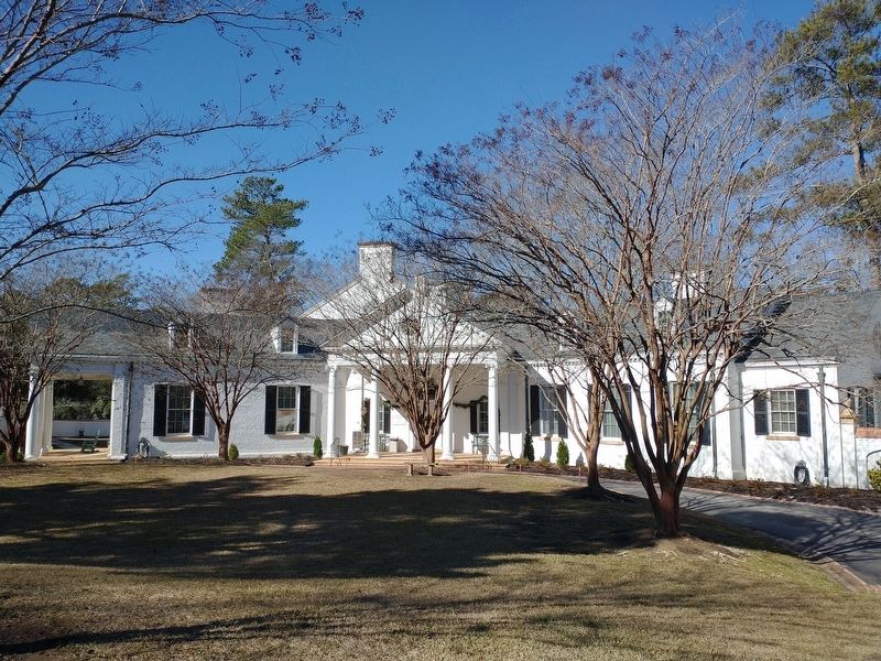
Near Newberry Street Southwest north of First Avenue Southwest, on the right when traveling south.
Built in 1931
Architect: Willis Irvin
Owner: Richard Howe 1931-1943
Boarding House for SRP Construction Workers 1951
Southern Methodist Bible College 1957-1961
First USC-Aiken Campus 1961-1973
Aiken County Public Library 1973-1989 . . . — — Map (db m239075) HM
On Laurens Street SW south of Richland Avenue W, on the right when traveling south.
On January 27, 1953, an explosion caused
by a natural gas leak killed ten people
and destroyed five buildings on the
northern half of this block. The five
buildings destroyed were Platt's Drug Store,
the Jones Electric Company (the site . . . — — Map (db m28716) HM
On South Boundary Avenue Southwest west of Laurens Street Southwest, on the right when traveling west.
One of the most famous longleaf pine forest residents is the red-cockaded woodpecker — RCW to their friends. This species used to live throughout the Southeast and as far west as Texas and Oklahoma. Unfortunately RCW numbers declined with the . . . — — Map (db m292174) HM
On South Boundary Avenue Southwest west of Laurens Street Southwest, on the right when traveling west.
Building a Future
In 1827 the SC Legislature granted a charter for the South Carolina Canal & Rail Road Company. Business owners in Charleston hoped to divert commercial traffic from the Port of Savannah by connecting Charleston to Augusta, . . . — — Map (db m292085) HM
On South Boundary Avenue Southwest west of Laurens Street Southwest, on the left when traveling west.
Why Build a Railroad?
In the early 1820 Charleston suffered an economic decline as Savannah began to control shipping traffic on the Savannah River. Businessmen such as William Aiken and Alexander Black were determined to get back their . . . — — Map (db m292081) HM
On South Boundary Avenue Southwest west of Laurens Street Southwest, on the left when traveling west.
The Solution
Engineers of the Charleston to Hamburg railroad built an Inclined Plane just like this to overcome the steep slope down to Hamburg.
What Exactly Is an Inclined Plane?
An inclined plane is a simple machine that . . . — — Map (db m292049) HM
On Greenville Street Northwest at Barnwell Avenue Northwest, on the right when traveling north on Greenville Street Northwest.
Aiken’s permanent Jewish community dates to 1890, when immigrants from Eastern Europe, many of them from Knyszyn, Poland, began to settle here. Adath Yeshurun Congregation (Congregation of Israel) held its first services in private homes or in . . . — — Map (db m239015) HM
On Laurens Street SW near The Alley, on the right when traveling north.
Aiken, chartered in 1835 and the county seat of Aiken County since its creation in 1871, was an early stop on the railroad line from Charleston to Hamburg. It was named for William Aiken (1779–1831), the first president of the S.C. Canal and . . . — — Map (db m9640) HM
On South Boundary Avenue Southwest west of Laurens Street Southwest, on the left when traveling west.
Aiken was one of America's first planned towns and it was a railroad town!
The SCC&RR Company hired engineers Andrew Alfred Dexter and Cyril Ouvier Pascalis to build the western leg of the Charleston to Hamburg railroad. The company also . . . — — Map (db m292073) HM
On Hampton Avenue Northwest at Florence Street Northwest, on the right when traveling east on Hampton Avenue Northwest.
Aiken Colored Cemetery. This cemetery, established in 1852 as a city cemetery, became Pine Lawn Memorial Gardens in 1988. The only burial ground for African Americans in Aiken until the mid-20th century, it was laid out by the City of Aiken . . . — — Map (db m239016) HM
On Park Avenue near York St. SE (U.S. 1), on the right when traveling east.
Aiken County, created in 1871 from parts of Barnwell, Edgefield, Lexington, and Orangeburg counties, was named for William Aiken, first president of the South Carolina Canal and Railroad Company. Older industries in the county today are textiles, . . . — — Map (db m9707) HM
On York Street SE at Richland Avenue (U.S. 78), on the right when traveling north on York Street SE.
In Commemoration Of The
Founding Of Aiken County
on
March 10, 1871
Celebrating 125 years
County Commissioners:
Sen. C.D. Hayne, Rep. Gloster Holland,
Rep. William B. Jones, Rep. Sam J. Lee,
William Peel, Rep. Prince Rivers, . . . — — Map (db m34610) HM
On Park Avenue near Chesterfield Street, in the median.
(South Face)
They gave their all in defense of
home, honor, liberty and the
independence of their native land.
They fought the patriots fight.
They kept the faith of their fathers
Forever honored
and forever . . . — — Map (db m272946) WM
Near Newberry Street Southwest north of 1st Avenue Southwest, on the right when traveling south.
Forged in 1882 at the Meneely Bell Foundry Troy, N.Y., the bell hung in the cupola of the Aiken County Courthouse 1882 to 1981.
In 1981, lightning cracked the bell, and caused a fire that destroyed the courthouse's cupola. — — Map (db m239076) HM
Near Newberry Street SW at New Lane SW, on the right when traveling south. Reported missing.
Forged in 1882 at Troy, N.Y., the bell hung in the courthouse 1882-1981.
In 1981, lightning cracked the bell, and caused a fire that destroyed the cupola. — — Map (db m239077) HM
On Williamsburg Street near Richland Street SE (U.S. 78), in the median.
The Aiken County Farmers’ Market, founded in 1951, was originally an open air market sponsored by the Edisto Grange. This building, which opened on May 21, 1954, was designed by Woodrow Jackson and built by the Aiken County chain gang. Farmers . . . — — Map (db m28630) HM
Near Newberry Street SW near 1st Avenue, on the right when traveling west.
Life in Aiken
The coming of the railroad was a major factor
in the birth of Aiken. The all-important cotton
crop and Graniteville fabrics could get to market.
Add to life in Aiken a lady lonesome for her
wealthy friends up North and you . . . — — Map (db m63263) HM
On York Street Northeast (U.S. 1) near Richland Avenue (U.S. 78), on the right when traveling south.
This church, founded in 1805, predates the city of Aiken and was first called Levels Baptist Church. Its first location was a mile south of present-day Aiken. In 1836 the congregation joined with the members of the Wise Creek congregation to . . . — — Map (db m10060) HM
On Hampton Avenue Northeast at Kershaw Street Northeast, on the right when traveling east on Hampton Avenue Northeast.
This park is the site of Aiken Graded School, a two-story brick school built 1924-25. It was built for black pupils in grades 1-7 and was one of almost 500 S.C. schools funded in part by the Julius Rosenwald Foundation 1917-1932. Black Aiken . . . — — Map (db m239018) HM
On Richland Avenue West (U.S. 1) near Morgan Street, on the right when traveling west.
Aiken Hospital. The first public hospital in Aiken, at the corner of Richland Ave. and Vaucluse Rd., was built in 1917 for the Aiken Hospital and Relief Society, with donations from members of the “Aiken Winter Colony.” The City of Aiken . . . — — Map (db m54518) HM
On Whiskey Road (State Highway 19) near Colleton Ave Southeast, on the right when traveling north.
The Aiken Institute, which gave this area the name of “Institute Hill,” was chartered in 1888. The main building, designed by I.F. Goodrich in 1891, includes a wing added in 1913. All grades attended the Institute until 1937, when a new high . . . — — Map (db m9942) HM
On Barnwell Avenue Northwest east of Lancaster Street, on the right when traveling east.
Aiken Preparatory School (APS), founded in 1916 as a boarding school for “junior gentlemen” in grades 4-8, was a fixture in the city of Aiken for almost 100 years. Louise “Lulie” Hitchcock (1867-1934), a leader among the wealthy Northerners in . . . — — Map (db m238832) HM
On Park Avenue SE at Union Street SE, on the right when traveling west on Park Avenue SE.
(Front)
The Aiken Railroad Depot was constructed in 1899 by the Southern Railway. Built largely to service the wealthy travelers who comprised the Aiken Winter Colony, including
members of the Vanderbilt, Mellon, and Astor families, the . . . — — Map (db m238821) HM
On Two Notch Road Southeast at Mead Avenue, on the left when traveling south on Two Notch Road Southeast.
(Front)
In 1941 a group including Pete Bostwick, Mrs. Ambrose Clark, and Skiddy von Stade Sr.
organized to build the Aiken Training Track (ATT) on 75 acres that included parts of the Post
and Mead polo fields. Frank Phelps designed the . . . — — Map (db m239215) HM
On Laurens Street NW (State Highway 19) at Edgefield Avenue NW, on the left when traveling south on Laurens Street NW.
In Memory of Those Who
Died in the Vietnam War
Adams, Dwayne Lonnie • Adams, Joseph Boyce • Barton, Jere A. • Boyd, Wayne • Butler, Linnell • Callahan, Clifton Eugene • Clark, Allen Howell • Douse, James Louis • Garrett, Alonzo • Gay, . . . — — Map (db m86815) WM
On Laurens Street Southwest at Hayne Street Southwest, in the median on Laurens Street Southwest.
An early Aiken Park
established by
The Historic Aiken Foundation
and the
City of Aiken
in 1973
This park contains two of the first street lights which were originally gs lights, and the paving bricks which were laid in the early . . . — — Map (db m292193) HM
On South Boundary Avenue Southwest west of Laurens Street Southwest, on the right when traveling west.
From archaeological and historical research, we know people have lived, used, and enjoyed the land that is now Hitchcock Woods for thousands of years. During a survey of the Woods, archaeological found stone tools such as arrowheads, spear . . . — — Map (db m292088) HM
On Laurens Street NW, on the right when traveling south.
In this building on
October 31, 1898
the author Jeff Scott
began collecting notes for
the Southern novel
Beneath The Glass Door.
Due to unforeseen circumstances
the book was not completed until
much later. Out of the scenic . . . — — Map (db m86818) HM
On Newberry Street Southwest north of First Avenue Southwest, on the right when traveling south.
Banksia, named for the yellow roses of the same name that grow here, was commissioned in 1931 by Richard Howe – Aiken Winter Colonist. The 14,000 sq. ft. Colonial Revival mansion, with 35 rooms, 15 bathrooms, and a ballroom, was designed by noted . . . — — Map (db m239074) HM
On Chesterfield Street NE near Richland Avenue (U.S. 78), in the median.
Near this spot on February 11, 1865
was fought one of the final Confederate
victories of the War Between The States.
Federal Cavalry commanded by Major
General Hugh Judson Kirkpatrick were
attacked by Confederate Cavalry
commanded by . . . — — Map (db m10061) HM
Near Union Street SE north of Sea Lane SE, on the left when traveling south.
Imagine if steam locomotives still ran through here. It would be so loud you might not hear the person next to you.
Because of the noise, railroad engineers used bells and whistles to alert passengers and workers that a train was arriving at . . . — — Map (db m238824) HM
On Gregg Avenue north of Augustus Drive, on the right when traveling north.
Built c. 1856 for James Parsons Carroll (1809-1883), this is the last surviving house from the original Kalmia village, a summer retreat for Charleston-area residents. An Edgefield lawyer born in Charleston, Carroll served several terms in the . . . — — Map (db m292037) HM
Near Union Street SE north of Sea Lane SE, on the left when traveling south.
Visitors to Aiken, today, arrive via interstates and airlines. Our Visitors Center and Train Museum stands as a reminder of the impact that the railway made on the establishment of this fine city.
From Hitchcock Woods (one of America's largest . . . — — Map (db m238830) HM
On Coker Springs Road SW, on the left when traveling west.
The source of water for early settlers.
A stagecoach stop on route from Abbeville to
Charleston, S.C. Deeded to City of Aiken 1844
by Wm. Peronneau Finley. Restored by many
friends in 1972.
(Upper Medallion)
The National . . . — — Map (db m56810) HM
On South Boundary Avenue SE at Newberry Street, on the right when traveling east on South Boundary Avenue SE.
The freshwater spring 1/2 mi. SE was used by prehistoric Indians. It was deeded to the town of
Aiken in 1844 by William Perroneau Finley (1803-1876) and furnished Aiken´s drinking water
throughout the 19th century. A regular stop on the . . . — — Map (db m63615) HM
Near York Street NE (U.S. 1) near Richland Avenue (U.S. 78).
In Memory of
the Confederate
soldiers who lost
their lives in
defense of Aiken,
Feb. 11, 1865
Erected by the Memorial
Association 1911
— — Map (db m88573) HM
On Laurens Street SW at Hoods Lane SW, on the right when traveling north on Laurens Street SW.
"Aiken Needs a Library Building."
Aiken had a subscription library as early as the 1870s but it was a floating library moored in private homes, stores, and downtown buildings. There was no permanent building and this lack became a rallying . . . — — Map (db m239078) HM
Near Newberry Street Southwest north of New Lane Southwest, on the right when traveling south.
This log cabin was built in 1808 by Frederich [Frederick] Ergle along the bank of the South Fork of the Edisto River in the former Edgefield District. The cabin was near the modern intersection of U.S. Highway 1 and Old Four Notch Road, which is . . . — — Map (db m292048) HM
On South Boundary Avenue Southwest at Laurens Street Southwest, on the right when traveling west on South Boundary Avenue Southwest.
Points of Interest:
❶ 1977 Burn/Cuthburt Ridge
In 1977 lightning ignited a 20-acre wildfire between Cuthbert Ridge Line and the trail that is now known as 1977 Burn. Red-cockaded woodpeckers make this area their home.
❷ . . . — — Map (db m292170) HM
Near Union Street SE north of Sea Lane SE, on the left when traveling south.
Dining cars did not become standard equipment on railroads until after the Civil War. Before food was served on trains, meal options for passengers were less than appetizing. Roadhouses near regular train water-stops offered a limited selection of . . . — — Map (db m238826) HM
On Barnwell Avenue Northwest near Laurens Street, NW (State Road 19), on the right when traveling west.
This church, founded in 1858 with 14 charter members and W. Peronneau Finley and John D. Legare as elders, first met in the Aiken Town Hall on Laurens St. Its first permanent sanctuary, a frame building designed by Charleston architect Edward . . . — — Map (db m29274) HM
On Park Avenue Southwest east of Laurens Street Southwest, in the median.
He was first elected to the Aiken City Council in November 1985 and was appointed mayor pro tempore two years later. He was elected mayor in 1991 and served for 24 years, retiring in 2015.
While serving as mayor, he was the chair of Aiken's . . . — — Map (db m239213) HM
A sesquicentennial memorial gift to the city of Aiken by the family of Thomas H. Williamson (1888-1962), former county treasurer, member of the Aiken County Historical Commission and direct descendant of this cabin's builder. — — Map (db m102353) HM
On Richland Avenue East at Kershaw Street SE, on the right when traveling east on Richland Avenue East.
This is one of the oldest historically Black churches in Aiken. It was organized in 1866 by formerly enslaved members of Aiken First (Front) Baptist Church. They were led by their first pastor. Rev. John G. Phillips, who was assisted by Rev. . . . — — Map (db m239072) HM
On Richland Avenue East (U.S. 78) at Gaston Road, on the right when traveling east on Richland Avenue East.
(Front)
The turn-of-the-century barn to the south is a notable example of eclectic Victorian, brick, U-shaped barn design and construction. It has a rare working early 20th century carriage lift. In 1909, David W. Gaston, Sr. (1860~1931) . . . — — Map (db m239219) HM
On Richland Avenue West (U.S. 78) 0.1 miles west of Newberry Street North West, in the median.
Mayor
1946 - 1952
1957 - 1991
His office was our city's sidewalks and storefronts, and from his walks about the downtown he gained the information needed for leadership.
He was an advocate for harmony and teamwork, regardless of . . . — — Map (db m15136) HM
On Highland Park Drive near Highland Park Terrace SW, in the median.
The Highland Park Hotel, Aiken’s first grand tourist hotel, stood atop this plateau. It was built in 1869-70 and opened in 1870. A four-story Second Empire wing built in 1874 doubled its capacity to 350 guests. Open from November to June, it . . . — — Map (db m29974) HM
Hitchcock Woods, one of the largest urban forests in the United States, is an area consolidated between 1891 and 1898 by Celestine Eustis (d. 1921), Thomas Hitchcock (1860-1941), and William Whitney (1841-1904). Described as "the greatest equine . . . — — Map (db m9776) HM
On Laurens St SW, on the right when traveling south.
Josef Casimir Hofmann, internationally
known Polish pianist, resided with his
wife, Aikenite Marie Eustis Hofmann, in
a three~story house located several
hundred feet west of here. Born near
Cracow, Poland, he was recognized as a
gifted . . . — — Map (db m10184) HM
Near Union Street SE north of Sea Lane SE, on the left when traveling south.
The steam engine had a dramatic impact on the development of transportation and industry in the 19th century. Indeed, it was the steam engine that powered the industrial revolution.
How does a steam engine work? The principal is simple. Water . . . — — Map (db m238827) HM
On South Boundary Avenue Southwest west of Laurens Avenue Southwest, on the left when traveling west.
1827 The SC General Assembly charters the South Carolina Canal and Rail Road Company (SCC&RR).
1828 William Aiken is appointed president of the SCC&RR Company.
1829 Col. William Howard and Col. J.B. Petitval complete surveys . . . — — Map (db m292050) HM
On Highland Park Avenue Southwest at Highland Park Terrace Southwest, on the left when traveling west on Highland Park Avenue Southwest.
Near here is the site of the Inclined Plane, a crucial segment of the original S.C. Railroad. The railroad's mainline was built from 1830 to 1833 by the S.C. Canal & Rail Road Co. to connect Charleston to Hamburg and the Savannah River. The . . . — — Map (db m292039) HM
Lawmaker
Supreme Court Justice
"Assistant President"
Secretary of State
Peacemaker
Governor
Citizen of Aiken, 1900-1926
He gave a lifetime of service to state, nation, and the world. — — Map (db m15133) HM
On Richland Avenue (U.S. 78) at Gregg Avenue, on the left when traveling east on Richland Avenue.
This is the site of Kalmia, the home and plantation of William Gregg (1800-1867), pioneer industrialist of the antebellum South. A native of Va., Gregg moved to S.C. in the 1820s, becoming a craftsman and merchant in Columbia and Charleston. In . . . — — Map (db m238816) HM
On Newberry Street Southwest at New Lane Southwest, on the right when traveling south on Newberry Street Southwest.
This garden is dedicated to the memory of Leah Walker (May 10, 1982 - April 10, 2023). Leah served as the Site & Events Manager of the Aiken County Historical Museum from September of 2016 until her passing in April of 2023.
Leah was a . . . — — Map (db m292046) HM
On Laurens Street Southwest at Downing Street Southwest, on the right when traveling south on Laurens Street Southwest.
One of the oldest houses in Alken, this was home to the Legare family, including writer James Mathewes Legare (1823-1859), who lived here beginning in 1846. Portions of the house date to as early as 1837. The south wing was built c. 1852 as a . . . — — Map (db m213324) HM
On South Boundary Avenue Southwest west of Laurens Street Southwest, on the right when traveling west.
Aiken's residents know trees are one of the city's greatest assets. Aiken has been recognized as a Tree City USA every year since 1985. Even the city's Visit Aiken logo has trees. In fact, Aiken is home to one of the most diverse collections of . . . — — Map (db m292169) HM
On Richland Avenue West at Newberry Street Southwest, on the right when traveling east on Richland Avenue West.
McGhee Block. This seven-storefront brick building was built in 1920 by African American contractors and cousins William M. McGhee and Albert B. McGhee. Known as the McGhee Block, it housed such businesses as stores, dry cleaners, . . . — — Map (db m292192) HM
On East Pine Log Road (State Highway 302) at Notch Road Southeast, on the right when traveling east on East Pine Log Road.
This church, formally organized in 1884, had its origins in a Sunday school class organized in 1874. With 16 charter members and Rev. Arthur Buist as its first minister, Millbrook built its first sanctuary here in 1886. The frame church, built by . . . — — Map (db m38281) HM
On South Boundary Avenue Southwest west of Laurens Street Southwest, on the left when traveling west.
Most of the Charleston to Hamburg rail line was a single track, but the Inclined Plane had two parallel sets of tracks adjacent to each other on a half-mile-long steep slope.
The tracks ran through an Engine House positioned at the top . . . — — Map (db m292065) HM
On Newberry Street SW at Richland Avenue West (U.S. 1), in the median on Newberry Street SW.
The town of Aiken, on land donated by Mr. Beverly M. Rodgers to the S.C. Rail Road in 1834, was laid out around a core of 27 city blocks bounded by Edgefield and Park Aves. and Newberry and Williamsburg Sts. This area was surveyed by civil . . . — — Map (db m29613) HM
On South Boundary Avenue Southwest west of Laurens Street Southwest, on the left when traveling west.
Welcome!
Hitchcock Woods is one of the largest urban forests in the country with nearly 2,100 acres of land, seven entrances, and over 70 miles of trails. The Hitchcock Woods Foundation is dedicated to protecting and preserving the Woods. . . . — — Map (db m292172) HM
Near Scholar Loop south of College Station Drive, on the right when traveling south.
This plantation house, first known as “Edgewood,” is an excellent example of Federal-era architecture. Originally near Edgefield, it was built in 1828 for Francis W. Pickens (1807-1869), state representative and senator, congressman, U.S. . . . — — Map (db m43154) HM
On South Boundary Avenue Southwest west of Laurens Street Southwest, on the right when traveling west.
There is nothing more lovely than a garden spilling over with bright blooms and sweet smells. But flower gardens do more than offer us beautiful places to enjoy. Flower gardens are a buffet of nectar and pollen for bees, butterflies, beetles, and . . . — — Map (db m292168) HM
On Laurens Street Southwest at Hoods Lane Southwest, on the right when traveling north on Laurens Street Southwest.
Space voyages are among the most inspiring and iconic endeavors of the 20th century, yet practical realities have limited spacefaring ambitions. Providing electricity and heat to a spacecraft in flight is challenging, given the vast distances and . . . — — Map (db m214812) HM
On Mead Avenue east of Magnolia Street Southeast, on the right when traveling east.
Polo in Aiken. Polo was first played in the U.S. in 1876. In 1882, the first polo match in S.C. took place in Aiken. The sports introduction here was credited to Clarence S. Wallace of N.Y. He and other "Winter Colonists" soon after . . . — — Map (db m292183) HM
On South Boundary Avenue Southwest west of Laurens Street Southwest, on the left when traveling west.
When William Aiken and Alexander Black decided to build the Charleston to Hamburg railroad, they also had to decide how to power their trains.
Chief Engineer Horatio Allen convinced them to try the leading-edge technology of the day– the . . . — — Map (db m292068) HM
On Robert M. Bell Parkway (State Highway 19,118) near Trolley Line Road, on the right when traveling north.
Named in 1985 by action of the Aiken County Legislative Delegation and Highway Commission in recognition of an outstanding citizen and his many contributions to the life and well being of his county, district, and state.
2nd District member, . . . — — Map (db m44725) HM
On York Street Southeast at Park Avenue Southeast, on the right when traveling south on York Street Southeast.
For decades, Brother André served as the doorkeeper for the congregation of the Holy Cross in Montreal, Quebec. This humble man welcomed all and prayed with the sick and suffering.
He is credited with many miraculous healings.
Brother . . . — — Map (db m292044) HM
On Kershaw Street NW, on the right when traveling north.
This school was founded by the Freedmen's Bureau shortly after the Civil War to educate freedmen, women, and children. In 1868 Martha Schofield, a Quaker from Pennsylvania, came to Aiken and began her long career as superintendent. The school soon . . . — — Map (db m28821) HM
On Laurens St. SW near Park Ave SW, on the right when traveling south.
Began first successful scheduled steam railroad service in America on December 25, 1830, and by 1833 its 136 miles from Charleston to Hamburg made it the world’s longest railroad. Now part of Southern Railway System. — — Map (db m9999) HM
On Park Avenue Southwest at Laurens Street Southwest, in the median on Park Avenue Southwest. Reported permanently removed.
Began first successful scheduled steam railroad service in America on December 25, 1830, and by 1833 its 136 miles from Charleston to Hamburg made it the world's longest railroad. Now a part of Southern Railway System. — — Map (db m292191) HM
On Richland Avenue SW (U.S. 78) at Newberry Street NW, on the right when traveling west on Richland Avenue SW.
This church has its origin in 1825 as a Methodist congregation on the Hollow Creek Circuit that predates the city of Aiken. Rev. John Reynolds was the
first circuit rider serving St. John's, which shared a minister with St. John in Graniteville . . . — — Map (db m10163) HM
On Pendleton Street SW (U.S. 1) at Hayne Avenue, on the right when traveling south on Pendleton Street SW.
This Episcopal Church (cornerstone laid Sept. 5, 1842) was consecrated Aug. 9, 1843. It is the city’s oldest church structure, having retained its Greek revival style through subsequent remodeling. Church purchased bell in 1853, Cornish Memorial . . . — — Map (db m19634) HM
On Laurens Street Southwest at Park Avenue Southwest, on the right when traveling north on Laurens Street Southwest.
In the late 1950s it was deemed impractical to construct public shelters for everyone. In response, President Eisenhower issued a National Shelter Policy that encouraged Americans to take responsibility in providing their own protection from . . . — — Map (db m292042) HM
On Laurens Street Southwest at Hayne Avenue Southwest, in the median on Laurens Street Southwest.
The Augusta and Aiken Railway, a 26-mile interurban electric trolley line between Augusta, Ga., and Aiken, operated from 1902 to 1929. In Aiken the line began at the corner of Park Ave. & Union St., proceeded west on Park, then north on Laurens . . . — — Map (db m239218) HM
On Laurens Street Southwest at Park Avenue Southwest, on the right when traveling north on Laurens Street Southwest.
Where you are standing is the location of the Aiken Municipal Fallout Shelter. This underground shelter, constructed in the 1960s, was designed to provide an emergency save-haven in the event of a nuclear attack on the United States.
A New . . . — — Map (db m239212) HM
On Richland Avenue, East (US 1) (U.S. 78), on the right when traveling east.
The Detection of the Neutrino, 1956
On August 27, 1956, at the Savannah River Plant (now Savannah River Site), Drs. Clyde L. Cowan, Jr. (1919-1974) and Frederick Reines (1918-1999) used P Reactor to detect the neutrino, a sub-atomic particle . . . — — Map (db m43146) HM
Near South Boundary Avenue SW near Newberry Street SW.
Originally located in China Springs, near Aiken, and believed to have been built in the 1890's this schoolhouse was given to the Aiken County Historical Commission by Mrs. Guerin Hermann of Sandersville, Georgia in 1975.
The one room . . . — — Map (db m63475) HM
On South Boundary Avenue Southwest west of Laurens Street Southwest, on the right when traveling west.
Did you know there was a time when you could step across Sand River? It was a dry riverbed except when it rained. Aiken's stormwater runoff naturally flows into Sand River. It worked well for many years until Aiken grew and the amount . . . — — Map (db m292176) HM
On Newberry Street Southwest at Park Avenue Southwest, in the median on Newberry Street Southwest.
The tracks of the S.C. Railroad, operated by the S.C. Canal & Railroad Company, ran here from 1833 to the 1850s. The company, chartered in 1827, began constructing a 136-mile long line from Charleston to Hamburg (near North Augusta) in 1830. . . . — — Map (db m36676) HM
Near Newberry Street Southwest at New Lane Southwest, on the right when traveling south.
In the fall of 1882, a group of German scientists arrived in Aiken to observe and document an astronomical phenomenon - the transit of Venus. Every 243 years, the planet Venus travels between Earth and the Sun for a time span of only six hours. . . . — — Map (db m292047) HM
On South Boundary Avenue Southwest west of Laurens Street Southwest, on the right when traveling west.
Longleaf pines are native to the southeastern United States. Mature longleaf pines can stand over 120 feet tall with a trunk three feet in diameter. These majestic pines can live for 250 years, some are known to be almost 500 years old! . . . — — Map (db m292175) HM
On South Boundary Avenue Southwest west of Laurens Street Southwest, on the left when traveling west.
The company began to be concerned about the Inclined Plane and its effect on passengers and freight shipments.
In 1845 they commissioned a study which recommended the Inclined Plane be eliminated.
Near Newberry St SW near New Lane SW. Reported permanently removed.
Iron heliometer tower, which served as an observatory, and housing for instruments, including powerful telescopes, used in viewing the December 6, 1882, Transit of Venus in Aiken, South Carolina. The observatory was built in two sections, each . . . — — Map (db m10193) HM
On South Boundary Avenue Southwest west of Laurens Street Southwest, on the left when traveling west.
For many years, all we knew about how the Charleston to Hamburg railroad was constructed and what it looked like were descriptions by several of the railroad's engineers including Horatio Allen, the records of the SCC&RR Company, and some . . . — — Map (db m292069) HM
On South Boundary Avenue Southwest at Newberry Street Southwest, on the right when traveling east on South Boundary Avenue Southwest.
For many years, the water trough was located behind the County Courthouse. The following are to be commended for their efforts in restoring and re-establishing the trough as its new location on South Boundary. — — Map (db m102364) HM
The Aiken Municipal Fallout Shelter is now empty, but in the late 1960s, it was stocked with food and regularly tested and maintained. It is a small concrete building buried under a mound of earth at Park Avenue and Laurens Street. This fallout . . . — — Map (db m292041) HM
On S Boundary Ave SE at Chesterfield St. S, on the right when traveling west on S Boundary Ave SE.
This park, laid out in 1904-05 was named for William Collins Whitney (1841-1904). Whitney, a lawyer, Secretary of the Navy 1885-1889 under Grover Cleveland, and financier, was also an avid sportsman and leading member of the "Aiken Winter . . . — — Map (db m10210) HM
On Newberry Street NW, on the left when traveling north.
URS Corporation on the occasion of the City of Aiken's 175th year, graciously donated this symbolic representation of William Aiken Sr. (1779-1831), for whom the city was named in 1835. Aiken was an entrepreneur and president of the South Carolina . . . — — Map (db m86825) HM
On Magnolia Street Southeast north of Grace Avenue Southeast, on the left when traveling north.
This cemetery dates to the 1820s and was in use prior to the founding of the Town of Aiken (1835). It was established by the local Williams family, who were among Aiken's earliest settlers and used this as their burial ground for several . . . — — Map (db m292181) HM
On York Street Southeast south of Ray Lane, on the right when traveling south.
The house was built for the family of William White Williams (1787-1845), a planter and S.C. legislator for Barnwell District (1830-1931). the core of the house may date to 1824, by which time the family lived at this site. In the 1830s, Williams . . . — — Map (db m292180) HM
On Laurens Street Southwest at Park Avenue Southwest, in the median on Laurens Street Southwest.
This Memorial is erected in the memory of deceased members of the Woodmen of the World whose individual resting places could not be marked
Woodmen of the World Regional Memorial
(List of Names, Camp . . . — — Map (db m10270) HM
On Laurens Street North West (State Highway 19) north of Jones Avenue, on the right when traveling north.
German prisoners of war were held in a camp on this site from November 1943 to May 1946. This camp, one of 21 in S.C., was at first a sub-camp of the POW camp at Camp Gordon (now Fort Gordon), in Augusta, Ga. It was later a sub-camp of Fort . . . — — Map (db m36396) HM
On Laurens Street Southwest south of Augusta Aiken Road (U.S. 78), on the left when traveling south.
Sustained Jewish settlement in Aiken dates to the 1890s. By 1920, a concentration of Jewish-owned businesses had opened along this section of Laurens Street and other streets nearby. The first known Jewish merchant in Aiken was Harris L. Polier, . . . — — Map (db m225550) HM
On Williston Road (U.S. 278) just west of Spann Hammond Road, on the right when traveling west. Reported missing.
On January 5, 1856, Governor James H. Hammond and eleven other farmers of this area organized the Beech Island Agricultural Club for the diffusion of agricultural knowledge and the regulation of illegal slave traffic. Monthly meetings and . . . — — Map (db m10080) HM
On Church Road (State Highway 581) west of Spann Hammond Road (State Highway 1139), on the right when traveling west.
This church was organized in the Beech Island Academy on January 21, 1832, with Rev. Iverson Brooks as its first minister and Mathias Ardis and Randolph Bradford as its first deacons. This sanctuary, built on land donated by James T. Gardner . . . — — Map (db m9992) HM
On Williston Road (U.S. 278) near Hammond Road, on the left when traveling east.
Downer Institute & School
Downer Institute, founded in 1843, was originally located 1.5 mi. NE of this site and operated until 1865. It was named for benefactor Alexander Downer (1752–1820), whose will established an orphanage and school . . . — — Map (db m9994) HM
1487 entries matched your criteria. The first 100 are listed above. Next 100 ⊳