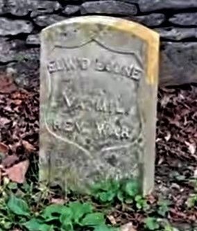
Edward Boone was killed by Indians here on the banks of Boone Creek on Oct. 4, 1780, while hunting with his brother Daniel. He was buried here the next day by Daniel and a party from Boone’s Station, near Athens, Ky, where Edward, Daniel and their . . . — — Map (db m172021) HM
On Cane Ridge Road (Kentucky Route 537) at See Road, on the left when traveling south on Cane Ridge Road.
Death site of Edward Boone, a brother of renowned Kentucky pioneer Daniel Boone. Edward was killed by Indians here Oct 1780 at age 40 while hunting with Daniel. Boone Creek named for Edward. Daniel and Edward wed sisters, Rebecca and Martha Bryan, . . . — — Map (db m171825) HM
On Russell Cave Road (Kentucky Route 353) 0.1 miles south of Centerville Lane, on the left when traveling south.
Established in 1867 under Rev. Thomas Gant after members left the fellowship of First Baptist Church, Paris, Rev. Elisha Green, pastor. Current church structure of wood mold brick built in 1904. Membership includes descendants of the original . . . — — Map (db m170051) HM
On Main Street north of East 5th Street, on the right when traveling north.
Born in Millersburg, Kidd devoted much of her life to civil rights causes. Served as representative in Ky. state legislature, 1968-85, earning her nickname, “Lady of the House.” Kidd led Ky.'s ratification of 13th, 14th, and 15th amendments to . . . — — Map (db m123690) HM
On Main Street 0.1 miles north of East 11th Street, on the right when traveling north.
Although it was a military academy,
its goal was to educate young men &
women in a structured, disciplined,
and challenging environment to
prepare them for leadership roles
in military or civilian life. Army
Cadet Corps purchased property in . . . — — Map (db m217853) HM
On Main Street (Business U.S. 68) at 9th Street, on the right when traveling north on Main Street.
Alexander House
The federal style house was built for William W. Alexander, a state representative 1848-52. His father, William Alexander, owned a hemp factory until 1856, which was operated by 100 enslaved people. At 600 feet, it had one of . . . — — Map (db m170055) HM
Near Main Street at Ardery Place, on the left when traveling north.
Soldiers of the American Revolution Who Died Citizens of Bourbon County
Samuel Brice • Isaac Darnell • James Duncan • James Hughes • James Hutchinson • John Luckie • Alexander Mitchell • John Moore • Robert Purdy • William Turner • Benjamin . . . — — Map (db m231274) WM
On Main Street at Ardery Place, on the left when traveling east on Main Street.
Dedicated May 25, 1986
In memory of those who gave their lives
• Walter K. Morris SSgt Air Force Apr. 18, 1927 – Oct. 24, 1963
• Donald I. Rankin SP4 Army Apr. 14, 1940 – Nov. 24, 1966
• Benjamin M. Brothers III PFC Marines Sept. 25, 1947 . . . — — Map (db m218140) WM
On Ardery Place at High Street (U.S. 460), on the right when traveling east on Ardery Place.
This building is dedicated to
the men of Bourbon County who served their country
during the World War.
1917 – 1918
Sacred to the memory of those who died for
Liberty, Justice and Peace.
Charles Adair * Joseph H. Holt * . . . — — Map (db m123689) WM
On Main Street (U.S. 460), on the left when traveling north.
Named for the royal French family who aided the colonies in the War of Independence. Bourbon was one of nine Virginia counties formed before Kentucky became a state in 1792. From its original area all of twenty-four counties and parts of ten other . . . — — Map (db m43621) HM
On U.S. 27 at Highway 1876, on the right when traveling south on U.S. 27.
Bourbon Whiskey
Named after Bourbon Co. because of quantity and quality of whiskey produced within its borders. Made from a fermented mash of at least 51% corn, with less wheat, rye, or barley, yeast and limestone water. Distilled at no more . . . — — Map (db m35597) HM
On Cane Ridge Road (Kentucky Route 537) at Steele Road on Cane Ridge Road.
Built by Presbyterians, 1791. Here Barton W. Stone began his ministry, 1796. Famous revival attended by pioneers of many faiths, 1801. Springfield Presbytery dissolved and "Christian Church" launched, June 28, 1804. — — Map (db m9724) HM
On Colville Road (Kentucky Route 3118) north of Endicott Lane, on the right when traveling north.
Colville Covered Bridge Built in 1877, this bridge spans Hinkston Creek. It is of Burr truss construction, which is the multiple king post type. The single span is 124 feet long and 18 feet wide. It was restored by Louis Bower in 1913 and by . . . — — Map (db m171786) HM
On Bank Row Street (U.S. 460) at High Street (U.S. 460), on the left when traveling west on Bank Row Street.
(obverse)
July 18, on its first Ky. raid Gen. John Hunt Morgan's cavalry rode to Paris from victory at Cynthiana. After holding out for days citizen groups surrendered. Warned of Union force nearby, CSA escaped pursuit, returned to Tenn. . . . — — Map (db m97145) HM
On High Street at Ardery Place, on the right when traveling south on High Street.
Dedicated in honor of
Mary Desha
of Kentucky
one of the four founders of the
National Society, Daughters of the American Revolution
restoration commenced 1940 the Golden Jubilee Year, N.S.D.A.R.
by the
Kentucky Society, . . . — — Map (db m245039) HM
On High Street (U.S. 460), on the right when traveling south.
This log building lined with adz-hewn cherry was built as a tavern. In 1795 it became first post office in Paris. Thomas Eades then served as tavern owner and postmaster. Robert Trimble had home and law office here before becoming U.S. Supreme Court . . . — — Map (db m43626) HM
On Winchester Street (Kentucky Route 627) at Vine Street, on the right when traveling south on Winchester Street.
Sites of birthplace of Garrett A. Morgan, and Branch School, which he attended, are ¼ mile south. He invented the tri-color traffic signal, forerunner of the present type, and a gas mask worn in rescue work at Cleveland, Ohio, 1916. His mask was the . . . — — Map (db m170056) HM
On High Street at 9th Street, on the right when traveling south on High Street.
First Christian Church organized 1827 by Thomas Allen, John Gano, and six "brave and forthright" women. Part of movement led by Barton W. Stone out of 1801 Cane Ridge Revival promoting Christian unity on New Testament authority. Prominent from its . . . — — Map (db m170054) HM
On Russell Cave Road (Kentucky Route 353) 0.3 miles south of Centerville Lane, on the right when traveling south.
Frankfort & Cincinnati Railroad
Built 1888-90 as the Kentucky Midland Railroad, it spanned 40 miles from Frankfort to Paris. Had connections on both ends to the L&N. Name changed to Frankfort & Cincinnati in 1899, but it had no connections . . . — — Map (db m170050) HM
On Winchester Street (Kentucky Route 627) at Link Avenue, on the right when traveling south on Winchester Street.
This lawyer, state legislator, and congressman, who played leading role in preventing 1861 secession of Kentucky, lived 1 block north. Davis represented Bourbon Co. in legislature. In Congress, 1839-47, 1861-72; Ky. Const. Conv., 1849. A Whig ally . . . — — Map (db m170079) HM
On U.S. 27 at Hutchison Station Road ( Route 1939), on the right when traveling north on U.S. 27.
Hopewell, one of the oldest Presbyterian churches in Bourbon County, has held worship services since 1785. The first congregation included Dutch settlers. It was recognized by the Transylvania Presbytery in 1787. Original church was located near . . . — — Map (db m218204) HM
On Main Street (U.S. 460), on the left when traveling north.
John Edwards 1748-1837
As early legislator, Edwards was member of the Virginia House of Delegates in 1781-83, 1785, 1786. He was a delegate to the convention to ratify Federal Constitution, June 1788, and to conventions that separated . . . — — Map (db m43623) HM
On Georgetown Road (U.S. 460) east of Clay Kiser Road, on the right when traveling east.
Robert Johnston, a Revolutionary War captain, was born in Virginia in 1749. He and his wife operated a tavern in their house here from 1796-1812. Located on what was the main road between Maysville and Lexington, this inn served stage and horseback . . . — — Map (db m67703) HM
On Winchester Road (Kentucky Route 627) 0.2 miles Stoney Point Road, on the left when traveling north.
Site of birthplace and early home of John Fox, Jr., famous Kentucky author, born 1862, graduated from Harvard in 1883. Died, 1919. Focusing on life in the Appalachian area, he wrote 12 novels and 45 short stories, including The Little Shepherd of . . . — — Map (db m170082) HM
On Paris Cemetery 3rd Road west of Main Street (Business U.S. 68), on the left when traveling west.
The Paris Cemetery Gatehouse is a rare surviving example of Gothic architecture in Kentucky. John McMurtry was the Lexington builder/architect who had worked with Alexander Jackson Davis, New York architect, as the builder of Loudoun House (ca. . . . — — Map (db m218183) HM
On Ruddells Mill Road (Kentucky Route 1940) at Old Ruddles Mill Road ( Route 1893), on the right when traveling south on Ruddells Mill Road.
Near his home Isaac Ruddell built a gristmill in 1788 on the north side of Hinkson bridge, and a sawmill in 1795 to be operated by his son, Abram. A 720-spindle cotton mill erected 500 feet west by Thomas and Hugh Brent in 1828, burned 1836. Soon . . . — — Map (db m171782) HM
On Russell Cave Road (State Road 353) at Silas Road on Russell Cave Road.
Organized by 20 members of the Cooper's Run Church in 1800, with the help of Ambrose Dudley, George Eve and Augustine Eastin. They built at this site on land given, 1798, by Charles Smith, Sr. The log structure was replaced by a brick house of . . . — — Map (db m35860) HM
Near Millersburg Road (U.S. 68) 1.4 miles east of Jackstown Road, on the right when traveling east.
Built of two-foot blue ash logs as home by Daniel Matheny, 1790. With Jacob Leer as class leader Mt. Gilead Methodist Society was organized here by Reverend Caleb Jarvis Taylor, author of revival hymns. Members were not allowed to buy slaves except . . . — — Map (db m218137) HM
Near Millersburg Road (U.S. 68) 1.4 miles east of Jackstown Road, on the right when traveling east.
Here stood Mt. Gilead Methodist Church
on land given by Daniel Matheny in 1790,
a gift confirmed by Thomas Jones, Sr.,
the eventual owner.
The word “Gilead” is defined in Genesis
as “hill of witness” and the adoption of
this name was a . . . — — Map (db m218138) HM
On Russell Cave Road (Kentucky Route 353) 0.3 miles south of Hawkins-Cummins Road, on the right when traveling south.
Originally a 1,400 acre land warrant, Townsend Springs was settled by John Townsend in 1775-1776. With Capt. John Hinkston Townsend traveled Ohio River exploring Shawnee territory. Named Townsend Creek in 1776. Townsend raised corn, sold to . . . — — Map (db m170052) HM
On High Street (U.S. 460) south of Ardery Place, on the left when traveling south.
Born September 23, 1800-Died May 4, 1873 Famous for his eclectic readers which introduced thousands of children to the treasures of literature. At this site he taught from 1823 to 1826 before joining the faculty of Miami University. — — Map (db m50653) HM
Near Ford Hampton Road, on the right when traveling north.
Fort Boonsborough Site has been designated a National Historic Landmark. This site possesses national significance in commemorating the history of the United States of America. — — Map (db m210654) HM
On Jones Nursery Road 0.3 miles north of Athens Boonesboro Road ( Route 418), on the right when traveling north.
Home of Richard Hickman. Born in Va., 1757. Built house in 1797. Clark county's first legislative representative, 1793-98. Member 1799 Ky. Constitutional Convention. General in the Ky. Militia. State: senator, 1800-8, 1811-12, 1819-22. Lt. Gov., . . . — — Map (db m169699) HM
On Athens Boonesboro Road (Kentucky Route 418), on the right when traveling west.
Composer, author, and ballad singer
John Jacob Niles (1892-1980) built
Boot Hill Farm here in 1939. Niles
composed the songs “I Wonder as
I Wander,” “Black Is the Color of
My True Love's Hair,” and “Go 'Way
from . . . — — Map (db m169683) HM
On Athens Boonesboro Road (Kentucky Route 418) east of Jones Nursery Road, on the left when traveling east.
Jones Nursery
Griffin Fauntleroy Jones began one of Kentucky’s earliest commercial nurseries. He sold fruit and ornamental trees, shrubs, and vines. Many orchards in Clark and surrounding counties were supplied from Jones’ Nursery. . . . — — Map (db m169688) HM
On Cleveland Avenue west of South Main Street (U.S. 60), on the left when traveling west.
CSA Gen. John H. Morgan's cavalry first raided Ky. July, 1862. Took Cynthiana but, faced by large USA forces, withdrew. Destroyed arms here on 19th and went to Richmond.
On last raid, June 1864, after two battles at Mt. . . . — — Map (db m239230) HM
On Cleveland Avenue west of South Main Street (U.S. 60), on the left when traveling west.
CSA Gen. John H. Morgan's cavalry first raided Ky. July, 1862. Took Cynthiana but, faced by large USA forces, withdrew. Destroyed arms here on 19th and went to Richmond.
On last raid, June 1864, after two battles at Mt. . . . — — Map (db m239231) HM
Near Ford Road/4 Mile Road (Kentucky Route 1924) 1.2 miles south of Boonesboro Road ( Route 627), on the left when traveling south.
Fortifying Central Kentucky
The small earthwork above was just one part of an overall defensive strategy devised by the Union army to guard against Confederate raids. It was part of a grand plan put forth by Capt. Thomas B. Brooks.
In . . . — — Map (db m74633) HM
Near Ford Road/4 Mile Road (Kentucky Route 1924) 1.2 miles south of Boonesboro Road ( Route 627), on the left when traveling south.
Hauling Supplies
This trail follows the road that took soldiers and supplies from the road below to the earthwork above. It is uncertain whether the military built the road or simply improved an existing trail or road.
The men and . . . — — Map (db m74720) HM
On West Lexington Avenue (U.S. 60) at McCann Drive, on the right when traveling west on West Lexington Avenue.
Born in Winchester, Allen Tate was a teacher and writer of prose and poetry of international fame. Also a leader of "New Criticism" poets and group known as Agrarians that supported the southern tradition. Helped found poetry magazine, "The . . . — — Map (db m164254) HM
Near Ford Road/4 Mile Road (Kentucky Route 1924) 1.2 miles south of Boonesboro Road ( Route 627), on the left when traveling south.
The Front Moves South
Capt. Thomas Brooks' plan for the defense of the Kentucky River was never completely realized. The reason lies in the shifting fortunes of war. In 1863, General Ambrose Burnside was sent to Kentucky to lead an . . . — — Map (db m74645) HM
On Athens Boonesboro Road (Kentucky Route 418) north of Boonesboro Road ( Route 627), on the right when traveling south.
On July 14, 1776, Daniel Boone's daughter, Jemima, and Richard Callaway's daughters, Betsey and Fanny, left Fort Boonesborough to canoe on the Kentucky River. They drifted close to the bank near this spot and were captured by five Native . . . — — Map (db m169694) HM
Near Ford Road (Kentucky Route 1924) 1.2 miles south of Boonesboro Road ( Route 627), on the left when traveling south.
Construction began in early 1863
Work on the Boonesboro earthwork progressed slowly, in part because of Confederate raids and in part because of bad weather, but by late spring or early summer the earthwork was complete.
In 1863, there . . . — — Map (db m74476) HM
On Paris Road (Kentucky Route 627) 1.5 miles south of Austerlitz Road/Thatchers Mill Road ( Route 57), on the left when traveling south.
Home of two Revolutionary War officers: built about 1793 by Col. Nathaniel Gist 1735-1796 and Gen. Charles Scott 1739-1813, Governor of Kentucky 1808-1812 who married the widow Gist, 1807. — — Map (db m170085) HM
On Van Meter Road west of Rennick Station Road, on the right when traveling west.
Capt. Isaac Cunningham 1778-1824 Commanded a company of Kentucky Mounted Volunteer Militia from Clark and Bourbon counties during the War of 1812. Served in state legislature 1816 and 1827. Sheriff & Clark County magistrate. Visitors to his . . . — — Map (db m171798) HM WM
On West Lexington Avenue (U.S. 60) just east of Hospital Drive, on the right when traveling west.
Came from Va. to Boonesborough, 1776. Builder of Strode's Station, 1779, the largest and most important fortified area in Clark County during the early settlements and bloody Indian wars. Indians attacked station 1781, and later. Two men killed . . . — — Map (db m159696) HM
On South Main Street south of Cleveland Avenue, on the right when traveling south.
Clark County, named in honor of Revolutionary War hero General George Rogers Clark, was created in 1792. A two-room log cabin courthouse built here in 1794 on land donated by John Baker. Replaced by two-story brick bldg. in 1797. Third . . . — — Map (db m67785) HM
On Lexington Road (U.S. 60) west of Clintonville Road, on the right when traveling west.
Clark County Hemp. One of the ten Bluegrass counties which produced over 90 percent of the entire country's yield in late 1800s. Production increased from 155 tons in 1869 to over 1,000 tons in 1889, valued at about $125 per ton. In 1942, . . . — — Map (db m170047) HM
On Cleveland Avenue at Wall Street on Cleveland Avenue.
Dedicated to the memory of those from Clark County who gave their lives in defense of humanity in the World War.
"As they served America in time of war, yielding their last full measure of devotion, may we serve America in time of peace, so . . . — — Map (db m164245) WM
On Bucknerville Road south of Colby Road (County Route 1927), on the left when traveling south.
Built in 1820s by Colby Taylor as a place of rest and entertainment on stage road from Winchester to Lexington. In 1832, President Andrew Jackson visited here on his trip to Winchester. During antebellum heyday in late 1840s, popular stop for those . . . — — Map (db m67745) HM
On Athens Boonesboro Road (Kentucky Route 418 at milepost 4.4), 0.1 miles east of Hidden Grove Lane, on the right when traveling west.
Colonel John Holder
John Holder commanded at Fort Boonesborough in 1779 and est. Holder's Station near the mouth of Lower Howard's Creek in 1782. He led a garrison at Vincennes in George Roger Clark's 1786 Wabash Campaign & was appointed a . . . — — Map (db m206154) HM
Near Ford Road/4 Mile Road (Kentucky Route 1924) 1.2 miles south of Boonesboro Road ( Route 627), on the left when traveling south.
The cliffs and slopes bordering the Kentucky River are home to a number of wildflowers and trees, some of which are pictured below. Common plants visible for much of the summer include pokeweed, blackberry, wild grape, and poison ivy. One frequently . . . — — Map (db m74790) HM
On Cleveland Street west of South Main Street (U.S. 60), on the left when traveling west.
For General George Rogers Clark, who came to Kentucky territory from Virginia, 1775. He commanded expedition into Illinois territory in 1778-79, taking the British forts which held the northwest for future US settlement, and capturing . . . — — Map (db m164154) HM
On Boonesborough Road (Kentucky Route 627) at Quisenberry Lane, on the right when traveling west on Boonesborough Road.
Daniel Boone, Surveyor. Daniel Boone earned substantial income as a deputy county surveyor (1783-1797), a dangerous job in frontier Kentucky. He made legal surveys in six Kentucky counties, including Clark. Boone’s first eleven were for . . . — — Map (db m163166) HM
On Schollsville Road (Kentucky Route 1960) near L.E. Junction Road ( Route 1960), on the right when traveling east.
Daniel Boone's Settlement
Daniel Boone selected this site at present-day Schollsville for his settlement in Kentucky by making an improvement here and growing corn in 1775 & 1776. The Virginia Land Commission approved his claim in 1779 at . . . — — Map (db m170089) HM
Near Ford Road/4 Mile Road (Kentucky Route 1924) 1.2 miles south of Boonesboro Road ( Route 627), on the left when traveling south.
Bridges, Fords and Ferries
Unlike the Ohio, the Kentucky River was never an important supply line for the Union Army. Because of its geology, the Kentucky acted as a barrier to the movement of supplies and men.
Much of the Kentucky . . . — — Map (db m74651) HM
On North Main Street (U.S. 60) 0.1 miles north of East Broadway Street, on the right when traveling north.
Winchester, KY was established in 1793. The city underwent a boom with the arrival of railroads and became a major banking and commercial center. Winchester’s location as the "Gateway to the Mountains" of Eastern KY . . . — — Map (db m164253) HM
On East Broadway Street at Park Avenue, on the left when traveling east on East Broadway Street.
In 1833 town trustees bought about an acre for $45 for public burial ground. First cholera epidemic in U.S. reached here. Seventy-five victims were buried here in 1833. John Ward, town trustee and a leader in forming cemetery, and his wife were both . . . — — Map (db m67786) HM
On Lexington Rd (U.S. 60) 0.9 miles east of Venable Road, on the right when traveling west.
On July 7, 1941, thirteen of Kentucky's rural electric co-ops formed East Kentucky Power Cooperative to relieve the electric power shortage common in rural areas. In 1951, Hugh L. Spurlock became EKPC's first general manager. Construction began . . . — — Map (db m167030) HM
On Cleveland Avenue west of South Main Street (U.S. 60), on the left when traveling west.
On this site, John Ward, a trustee for the new town of Winchester, operated a tavern in the early 1800s. The property later became the Sachett Academy for girls. In 1845 the First Christian Church erected a brick church which burned during the . . . — — Map (db m67755) HM
On South Burns Ave at Beckner Ave on South Burns Ave.
Home and monument of James Clark 1779-1839. Governor of Kentucky, 1836-1839. Member of Congress; Judge, Court of Appeals. As Circuit Judge he rendered his famous decision which set off the old and the new court fight in 1821. — — Map (db m67748) HM
On West Lexington Avenue east of Olde Potomac Avenue, on the right when traveling east.
Here lived five Hanson brothers, Civil War soldiers, USA and CSA. For USA: Col. Charles S., hero of Battle of Lebanon, July, 1863; Pvt. Samuel K.-died in service. For CSA: Brig. Gen. . . . — — Map (db m67753) HM WM
On College Street west of Wheeler Avenue, on the left when traveling west.
Homer Ledford (1927-2006) was a master craftsman, musician, and teacher. Born in Tennessee, he came to Kentucky to attend Berea College & graduated from Eastern Ky. University. Ledford founded the Cabin Creek Band in 1976 & led it for 30 years, . . . — — Map (db m67751) HM
On Kiddville Road (Kentucky Route 974) at Arrowhead Lane, on the right when traveling south on Kiddville Road.
Site of Eskippakithiki, sometimes called "Kentake," located on the Warrior's Path. This meeting place for traders and Indian hunters was the last of the Kentucky Indian towns. Occupied by the Shawnees, ca. 1715-1754. John Finley had a store here . . . — — Map (db m170094) HM
Near Ford Road (Kentucky Route 1924) 1.2 miles south of Boonesboro Road ( Route 627), on the left when traveling south.
An Unanswered Question
Was there a blockhouse at the Boonesboro earthwork? Because no written records have been found only intensive archaeological investigation can answer that question. However, Captain Thomas Brooks' recommendation . . . — — Map (db m74504) HM
On Winchester Road (Kentucky Route 15) 0.2 miles south of Goosey Road, on the right when traveling east. Reported damaged.
Near site of winter camp of Daniel and Squire Boone, Alexander Neeley, and John Stuart, 1769-70. Creek named by these pioneers after "Lorbrulgrud" of Gulliver's Travels, first known book brought to Kentucky. Corrupted to Lulbegrud. — — Map (db m167032) HM
On Boonesboro Road (Kentucky Route 627) at Old Stone Church Road, on the right when traveling south on Boonesboro Road.
Daniel Boone attended, Squire, Jr., Samuel, and Mary Boone baptized here. Church name changed, 1790, from Howard's Creek to Providence. William Bush, a member of Boone's second Ky. expedition, built the present stone structure of native limestone. . . . — — Map (db m30831) HM
On Ironworks Road west of Morris Road, on the left when traveling west.
In the burial ground, one-fourth mile east, are two rare Carrara marble tombstones carved in Italy by Joel Tanner Hart, the world renowned sculptor. He brought the stones to America, 1860, at time of unveiling of his great statue of Henry Clay in . . . — — Map (db m67788) HM
Near Ford Road/4 Mile Road (Kentucky Route 1924) 1.2 miles south of Boonesboro Road ( Route 627), on the left when traveling south.
Directly in front of you is a fragment of the original road built to take men and supplies from the road below, now KY 1924, to the earthwork. This road is now a foot trail, but many of Clark County's original roads are still in use. As the maps . . . — — Map (db m74728) HM
Near Ford Road/4 Mile Road (Kentucky Route 1924) 1.2 miles south of Boonesboro Road ( Route 627), on the left when traveling south.
"Civilization exists by geological consent" (Will Durant (1885 - 1981), American historian, philosopher, and educator)
Not many people stop to think about the rock beneath their feet, but it is the type of rock, its structure and . . . — — Map (db m74768) HM
On Colby Road (KY1927) west of Basin Springs Road, on the right when traveling west.
Site of home and farm from which Cluke enlisted in the Confederate army. Commissioned Colonel of 8th Regt. Ky. Cavalry CSA, Sept. 1862. Immediate action in Ky. won the confidence of Gen. John H. Morgan; was with Morgan in Dec. 1862 and July 1863 . . . — — Map (db m67706) WM
On Athens Boonesboro Road (Kentucky Route 418) east of Hidden Grove Lane, on the right when traveling east.
One of the first marked trails in Kentucky. The path began at Fort Boonesborough, crossed the Kentucky River here at Blackfish Ford, followed a buffalo trace up Lower Howard’s Creek about four miles then turned north and continued on to the Lower . . . — — Map (db m169692) HM
On Mount Sterling Road (U.S. 60) at Veterans Memorial Parkway ( Route 1958), on the right when traveling south on Mount Sterling Road.
Birthplace of Joel Tanner Hart, 1810, sculptor and poet. Began as stone-cutter, 1830. Went to Florence, Italy, 1849. Famed for busts: John Jordan Crittenden, Cassius M. Clay, Henry Clay, Andrew Jackson. Marble statues: Woman Triumphant, Il . . . — — Map (db m239189) HM
Near Ford Road/4 Mile Road (Kentucky Route 1924) 1.2 miles south of Boonesboro Road ( Route 627), on the left when traveling south.
Kentucky Primeval
Huge herds of bison graze in immense meadows beneath an open canopy of oak, ash, cherry, hickory, and sugar maple. Many of the trees are four feet or more in diameter. Elk and deer are abundant. Impenetrable canebreaks . . . — — Map (db m74754) HM
On North Main Street (U.S. 60) south of West Washington Street, on the right when traveling south.
(side 1)
On March 9, 1918, at 7:45p.m., a wall of a burned-out building collapsed onto The Pastime Theater near the end of the first showing. Eleven people were killed instantly and scores of others were injured. Eight of the dead were . . . — — Map (db m121377) HM
Near Ford Road/4 Mile Road (Kentucky Route 1924) 1.2 miles south of Boonesboro Road ( Route 627), on the left when traveling south.
Land Fever
Why did so many people brave the dangers of frontier life to come to Clark County and the Bluegrass? The answer is land -- cheap land, fertile land. The quest for land drove the settlement of Kentucky.
John Findley was a hunter . . . — — Map (db m74753) HM
On North Main Street (U.S. 60) at Depot Street, on the left when traveling north on North Main Street.
Where 4 Greek Immigrants served the Public from 1909 to 1973 John S. Collis William S. Collis George S. Stefanis Nick C. Anggelis Their lives were dedicated to their families, citizenship, provision of excellent food for their customers, fiscal . . . — — Map (db m265398) HM
Near Ford Road (Kentucky Route 1924) 1.2 miles south of Boonesboro Road ( Route 627), on the left when traveling south.
Army Engineers - A Proud Tradition
The Continental Congress first authorized an army with a chief engineer in 1775. In the years that followed, the Army Corps of Engineers supervised the construction of coastal fortifications, aided in . . . — — Map (db m74554) HM
Near Ford Road/4 Mile Road (Kentucky Route 1924) 1.2 miles south of Boonesboro Road ( Route 627), on the left when traveling south.
Constant Confederate Raids Forced the Union Army to Take Action
In the spring and summer of 1863 Confederate raids led by Col. Roy S. Cluke, Gen. John Pegram and Col. John S. Scott crossed and recrossed the Kentucky River. Their mission . . . — — Map (db m74678) HM
On Court Street at Wall Street, on the left when traveling east on Court Street.
This memorial is dedicated to those who served — In memory of those who died
PFC Willie Aldridge Army 1947 - 1968 •
PFC Floyd Barker Jr. Army 1948 - 1967 • . . . — — Map (db m164247) WM
Near West Main Street (U.S. 421) 0.1 miles north of Newtown Pike / Oliver Lewis Highway ( Route 922), on the right when traveling north.
Civil War Dead
An estimated 700,000 Union and Confederate soldiers died in the Civil War between April 1861 and April 1865. As the death toll rose, the U.S. government struggled with the urgent but unplanned need to bury fallen Union troops. . . . — — Map (db m123526) HM
Near East Main Street (U.S. 60) at Midland Avenue (U.S. 60), on the right when traveling west.
Arthur Boyd Hancock Sr. was the son of Capt. Richard Hancock, who established Ellerslie as the leading horse farm in Virginia late in the 19th Century. Arthur Sr. returned from the University of Chicago in 1895 to assist his father, and later, as . . . — — Map (db m58285) HM
known as Abe, was born in Midway, Woodford County. He began his career as a Thoroughbred
trainer for Abraham Buford, Bosque Bonita Far, Woodford County where he trained McWhitter (1876-1878). Perry became assistant trainer for Leonard W. Jerome, . . . — — Map (db m169792) HM
Near College View Avenue north of Rose Street when traveling north.
Adamstown
This interurban African-American community
was established in 1872 when working class
and skilled laborers began purchasing land
from George M. Adams to build homes.
Adams, a native of Barbourville, Kentucky,
was a slave owner . . . — — Map (db m169874) HM
Near West Main Street (U.S. 421) 0.1 miles north of Newtown Pike / Oliver Lewis Highway ( Route 922), on the right when traveling north.
Four score and seven years ago our fathers brought forth on this continent, a new nation, conceived in Liberty, and dedicated to the proposition that all men are created equal.
Now we are engaged in a great civil war, testing whether that . . . — — Map (db m138998) HM WM
On Avenue of Champions 0.2 miles east of S. Limestone (U.S. 27), on the right when traveling west.
"Winningest" coach in history of college basketball. Native Kansan who played under famed coach "Phog" Allen. Head coach at UK, 1930-72. Won 4 NCAA titles, won or tied SEC crown 27 times; coach of 1948 US Olympic team that won gold medal. Natl. . . . — — Map (db m134593) HM
On N. Broadway Road (U.S. 27, 68) near West Main Street (U.S. 421), on the right when traveling north.
Site of office building which housed prominent African-American physicians and pharmacy. Among the doctors who practiced here between 1909 and 1930 were Obed Cooley; Nathaniel J. Ridley; J.C. Coleman; John Hunter, first African-American surgeon at . . . — — Map (db m68193) HM
In the early 19th century, Southern Thoroughbred breeders, including those in Kentucky, relied on slaves to care for, ride, and train their horses. After emancipation, many of these former slaves remained on the farms and, to a large degree, it was . . . — — Map (db m202887) HM
Thoroughbred Trainers (24)
French Brooks 1861-1943 • Harry Brown ?-1890 • Edward Caldwell 1863-1912 • General Carter 1865-1936 • Oliver D. Chambers 1842-1909 • June Collins 1860-1930 • Polk Drake 1852-1889 • Moses Dupee 1832-1901 • Ben . . . — — Map (db m169816) HM
On East 7th Street south of Pemberton Lane, on the right when traveling south.
Earliest recorded cemetery in Lexington to be organized, owned, and managed by African Americans. The site has been in existence since 1869. Trustees of Benevolent Society No. 2 successfully operated cemetery. Many individuals buried here were . . . — — Map (db m169750) HM
Near East Main Street (U.S. 60) at Midland Avenue (U.S. 60), on the right when traveling west.
Son of a sporting coachman, who went down on the Lusitania, Alfred Gwynne Vanderbilt took over his family's Sagamore Farm in Maryland after his 21st birthday in 1933. He soon purchased Discovery, which campaigned across the country for several years . . . — — Map (db m58313) HM
506 entries matched your criteria. The first 100 are listed above. Next 100 ⊳