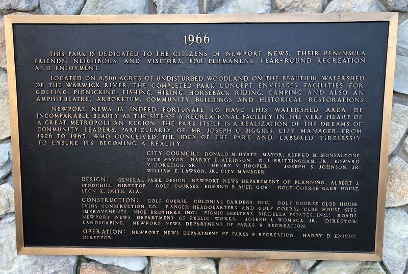
By Devry Becker Jones (CC0), January 18, 2021
Newport News Park Marker [Center plaque]
RANKED BY RELEVANCE
| On Constitution Way 0.4 miles east of Jefferson Avenue (Virginia Route 143) when traveling west. |
| Near Brooke Avenue at Harbour Street, on the left when traveling west. |
| On West Avenue at 27th Street, on the left when traveling north on West Avenue. |
| Near Washington Avenue at 41st Street, on the right when traveling west. |
| Near Jefferson Avenue (Virginia Route 143) at Constitution Way, on the right when traveling west. |
| On 25th Street near Washington Avenue, on the left when traveling south. |
| Near Washington Avenue at 35th Street, on the left when traveling west. |
| On Parish Avenue, on the left when traveling north. |
| Near West Avenue north of 26th Street, on the left when traveling north. Reported missing. |
| On 32nd Street at Huntington Avenue (U.S. 60), on the right when traveling east on 32nd Street. |
| On West Avenue at 25th Street on West Avenue. |
| On Martin L. King Jr. Way at Jefferson Avenue on Martin L. King Jr. Way. |
| On Martin L. King Jr. Way at Jefferson Avenue on Martin L. King Jr. Way. |
| On 25th Street at Washington Avenue, on the right when traveling north on 25th Street. |
| On Richneck Road 0.1 miles south of Jefferson Avenue ( Route 143), on the right when traveling south. |
| Near Yorktown Road (Virginia Route 238) south of Lebanon Church Road, on the right when traveling north. |
| On 41st Street at Washington Avenue, on the right when traveling east on 41st Street. |
| On Manor Place at Blacksmythe Lane, on the left when traveling east on Manor Place. |
| On 16th Street (Virginia Route 167), on the left when traveling west. |
| On Old Courthouse Way, on the left when traveling north. |
| On Washington Avenue at 41st Street, on the right when traveling west on Washington Avenue. |
| Near Warwick Boulevard (U.S. 60), on the right when traveling north. |
| Near Enterprise Drive 0.4 miles west of Warwick Boulevard, on the left when traveling west. |
| Near Enterprise Drive 0.4 miles west of Warwick Boulevard (U.S. 60), on the left when traveling west. |
| Near Atlantic Avenue just south of 14th Street, on the right when traveling south. |
| Near Atlantic Avenue just south of 14th Street, on the right when traveling south. |
| Near Pacific Avenue (U.S. 60) just south of 14th Street, on the right when traveling north. |
| On 27th Street (Virginia Route 143). |
| On James River Drive at Villa Road, on the left when traveling east on James River Drive. |
| On Huntington Avenue (U.S. 60) at 64th Street, on the right when traveling south on Huntington Avenue. |
| Near Museum Drive 0.2 miles north of Museum Parkway, on the left when traveling south. |
| On Huntington Avenue (U.S. 60) 0.1 miles east of Benton Way, on the left when traveling south. |
| On Warwick Boulevard (U.S. 60) at 68th Street, on the left when traveling north on Warwick Boulevard. |
| On Elmhurst Street 0.1 miles south of Yorktown Road ( Route 238), on the right when traveling south. |
| On 27th Street (Virginia Route 143 E) at Jefferson Avenue, on the left when traveling east on 27th Street. |
| On West Avenue at 25th Street, on the right when traveling east on West Avenue. |
| Near White Oak Trail at Dam #1 Bridge, on the left when traveling east. |
| Near Constitution Way east of Dam #1 Bridge, on the left when traveling east. |
| Near Constitution Way, on the right when traveling east. |
| Near Rivers Ridge Circle, on the left when traveling west. |
| Near Long Meadow Trail at Twin Forts Loop, on the left when traveling east. |
| On Twin Forts Loop east of Long Meadow Trail, on the left when traveling east. |
| Near Twin Forts Loop east of Long Meadow Trail, on the left when traveling east. |
| On Constitution Way just east of the Discovery Center, on the left when traveling east. |
| On Constitution Way, on the left when traveling east. |
| On Campsite Drive at Jefferson Avenue ( Route 143), on the right when traveling north on Campsite Drive. |
| Near Constitution Way, on the right when traveling east. |
| Near Twin Forts Loop at White Oak Trail, on the left when traveling east. |
| On Clubhouse Way at Dam #1 Bridge, on the right when traveling east on Clubhouse Way. |
| On Old Courthouse Way, on the left when traveling north. |
| On Jefferson Avenue 0.3 miles south of 6th Street, on the left when traveling south. |
| Near Washington Avenue at 35th Street, on the left when traveling west. |
| Near S. Liberty Street continued, on the left when traveling south. |
| On Chesapeake Avenue (Virginia Route 167) at East Avenue, on the left when traveling west on Chesapeake Avenue. Reported permanently removed. |
| On Warwick Boulevard (U.S. 60) at Franklin Road, on the right when traveling south on Warwick Boulevard. Reported missing. |
| On Deer Park Drive just west of Jefferson Avenue (U.S. 17), on the right when traveling west. |
| Near Harrison Road near Taylor Avenue. |
| On Manor Place at Blacksmythe Lane, on the left when traveling east on Manor Place. Reported damaged. |
| On Bland Boulevard 0.2 miles east of Patrick Henry Drive, on the left when traveling north. |
| On Beechmont Drive 0.1 miles west of Colleen Drive, on the right when traveling west. |
| On Wickham Avenue at 24th Street, on the right when traveling north on Wickham Avenue. |
| Near Riverpark Road at Biggins Circle, on the left when traveling north. |
| Near Washington Avenue at 35th Street, on the left when traveling west. |
| Near Biggins Circle 0.1 miles west of Hornet Circle. |
| On Hornet Circle 0.1 miles south of Warwick Boulevard (U.S. 60), on the right when traveling south. |
| On West Avenue at 25th Street, on the left when traveling west on West Avenue. |
| On Oak Avenue just east of 28th Street. |
| Near Washington Avenue at 35th Street, on the left when traveling west. |
| Near Washington Avenue at 35th Street, on the left when traveling west. |
| On Harpersville Road at Gatewood Road, on the left when traveling east on Harpersville Road. |
| On Middlebrook Avenue (Virginia Route 252) just west of South New Street, on the left when traveling south. |
| On Old Courthouse Way at Courthouse Drive, on the left when traveling north on Old Courthouse Way. |
| Near Old Courthouse Way at Grissom Way, on the left when traveling north. |
| On Riverview Parkway at Old Menchville Road, on the left when traveling west on Riverview Parkway. |
| On Old Grist Mill Lane at Warwick Boulevard (U.S. 60), on the right when traveling west on Old Grist Mill Lane. Reported damaged. |
| On Potter's Lane at Warwick Boulevard (U.S. 60), on the left when traveling west on Potter's Lane. |
| On Museum Drive 0.3 miles west of Boundary Road, in the median. Reported missing. |
| On Parish Avenue just north of 28th Street ( Route 143), on the left when traveling north. |
| Near Uncle Tom's Road (County Route 40) close to Park Street, on the right when traveling west. |
| Near Yorktown Road (Virginia Route 238) at Lebanon Church Road, on the right when traveling north. |
| Near West Avenue north of 26th Street, on the left when traveling north. Reported permanently removed. |
| Near Old Courthouse Way at Grissom Way, on the left when traveling north. |
| On Elmhurst Street 0.1 miles south of Yorktown Road ( Route 238), on the left when traveling south. |
| Near Constitution Way west of Old Stable Road, on the right when traveling east. |
| On Museum Drive 0.3 miles east of East Boundary Road, on the right when traveling north. |
| On Erben Avenue 0.6 miles east of Crowninshield Street, on the left when traveling east. |
| Near Shell Road at Maple Avenue, on the left when traveling south. |
| On Kerr Road 0.2 miles west of Victory Boulevard, on the right when traveling west. |
| On 5th Avenue (U.S. 60) east of 7th Avenue, on the left when traveling east. |
| On West Avenue at 30th Street, on the right when traveling east on West Avenue. |
| Near Toulouse Street east of Decatur Street, on the right when traveling east. |
| On State Highway 12 at Summerplace Drive, on the right when traveling north on State Highway 12. |
| Near Harrison Road 1 mile east of Harrison Road, on the left when traveling south. |
| On Monroe Avenue just north of Dillon Circle, on the right when traveling south. |
| On Harrison Road at Taylor Avenue on Harrison Road. |
| On Beverly Hills Drive at Blount Point Road, in the median on Beverly Hills Drive. |
| On Old Grist Mill Lane at Warwick Blvd (U.S. 60), on the right when traveling west on Old Grist Mill Lane. |
| On Dozier Road 0.5 miles south of Warwick Boulevard (U.S. 60), on the right when traveling south. |
286 entries matched your criteria. The first 100 are listed above.
Next 100 ⊳
Thin black lines indicate changes in relevance. Between each pair of lines entries are ordered geographically but all have the same relevance.* Inflectional forms of words are their plurals, singulars, and possessives as well as gramatical tenses and similar variations.
Nov. 19, 2026

