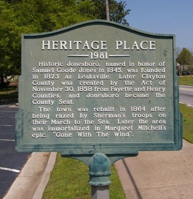
Historic Jonesboro, named in honor of Samuel Goode Jones in 1845, was founded in 1823 as Leaksville. Later Clayton County was created by the Act of November 30, 1858 from Fayette and Henry Counties, and Jonesboro became the County Seat. The town . . . — — Map (db m18815) HM
Aug. 31, 1864. When Gen. Hood in Atlanta heard that Federal forces had seized the railroad at Rough and Ready & suspecting an attack from that quarter, he ordered Gen. S. D. Lee’s A. C. [CS] to move back toward Atlanta to support Stewart’s A. C. . . . — — Map (db m18809) HM
Located near the center of fighting on the second day of the Battle Jonesborough (Jonesboro), the final major battle of the Atlanta Campaign, this cemetery contains the graves of up to 1,000 Confederate soldiers killed while fighting here on . . . — — Map (db m285180) HM
Cited in Official Records of military operations at Jonesboro, 1864; not the one standing in 1958, but one at rear on the old road of which the driveway is a remaining portion. Aug. 31, 1864, Hardee’s A. C. & Anderson’s div. of S. D. Lee’s, marched . . . — — Map (db m59426) HM
Ante-Bellum home of James F. Johnson, attorney, planter, merchant, Confederate officer and noted political figure in mid-nineteenth century Georgia. Johnson introduced the legislation which created Clayton County in 1858 and the bill which . . . — — Map (db m18183) HM
The M102 105 mm howitzer is used in air mobile (helicopter), attack plane, and light infantry operations. The weapon carried is lightweight welded aluminum, mounted on a variable recoil mechanism. The weapon is manually loaded and positioned, and . . . — — Map (db m285892) HM
On Nov. 15, 1864, after destroying Atlanta and cutting his communications with the North, Maj. Gen. W. T. Sherman, USA, began his destructive campaign for Savannah -- the March to the Sea. He divided his army [US] into two wings. The Left Wing . . . — — Map (db m36812) HM
Built in 1840 by Guy L. Warren, this Federal style family home became Confederate headquarters and hospital in 1864 during the Battle of Jonesboro. When Jonesboro fell, Union forces commandeered the house as Union headquarters and hospital to serve . . . — — Map (db m187123) HM
During the War Between the States, on this property to the north and west of this house was fought a major part of the Battle of Jonesboro, August 31st and September 1st, 1864. The battle was a struggle to capture the railroad to cut off supplies to . . . — — Map (db m12357) HM
In this vicinity were fought the engagements that ended the Atlanta Campaign of 1864. Confederate forces under Gen. Hardee, endeavoring to defend the remaining R.R. to Atlanta, against outnumbering Federal troops, Aug. 31 & Sept. 1 were forced to . . . — — Map (db m12330) HM
To the honored memory of
the several hundred unknown
Confederate Soldiers reposing
within this enclosure who fell
at the Battle of Jonesboro
August 31-September 1, 1864
These soldiers were of Hardee’s Corps, commanded by Maj. Gen. . . . — — Map (db m74212) WM
On Oct. 12, 1864, Maj. Gen. G.W. Smith, CSA (Street Commissioner, New York City, 1858-1861), assembled a force of militia at Lovejoy's Station (0.5 miles NE) to support Iverson's division of Wheeler's cavalry corps, which was picketing the roads . . . — — Map (db m113866) HM
Morrow Station was established as a depot on the Macon & Western R. R. when it was put into operation in 1846. A post office was opened here in 1871, and the City of Morrow was incorporated in 1943.
The birthplace and childhood home of Capt. . . . — — Map (db m37016) HM
On Nov. 15, 1864, after destroying Atlanta and cutting his communications with the North, Maj. Gen. W. T. Sherman, USA, began his destructive campaign for Savannah -- the March to the Sea. He divided his army [US] into two wings. The Left Wing . . . — — Map (db m125750) HM
August 30, 1864. On receipt of Hardee’s report from Rough and Ready of Federal threats to the M. & W. R. R., at Jonesboro, Hood directed Hardee & S. D. Lee [CS] to come to headquarters. The locomotive N. C. MONROE was sent for them at sunset: Hardee . . . — — Map (db m284682) HM
A way station on a stage line from Macon to upper Georgia in the 1840's; Post Office, Apr. 5, 1847 - June 24, 1869. Also, a cotton shipping point - the tavern an eating house for passengers -- after the Macon & Western (Central of Georgia) R.R. was . . . — — Map (db m284683) HM
Here stood the Rough and Ready Tavern or Old Bagley House which was at different times a residence, tavern, general store, arsenal & probably headquarters of Gen. Hardee Aug. 30, 1864. To this place, mentioned in “Gone With The Wind,” the people of . . . — — Map (db m284681) HM
After the occupation of Atlanta by Federal forces, Sept. 2, 1864, the remaining civilians were required to register for transportation to points north or south as desired. Those electing to go south were carried, with household goods, in army . . . — — Map (db m284684) HM
Sept. 1, 1864. Gen. S. D. Lee’s A. C., withdrawn from Jonesboro after the battle Aug. 31, camped in this vicinity enroute northward via the McDonough Rd., to aid Stewart’s A. C. [CS] in Atlanta if attacked by Federals at East Point. Learning of . . . — — Map (db m36744) HM
This memorial is dedicated to
the remarkable life of
Melvinia “Mattie” Shields McGruder.
She was born a slave in
South Carolina in 1844.
At age 6 she was brought to
the nearby Shields farm
in what is now
Rex, Clayton County, . . . — — Map (db m227406) HM
Aug. 30, 1864. Davis’ 14th A. C. [US], having moved from Red Oak to Shoal Creek Ch., was divided into 2 columns when marching therefrom to the Fayetteville Rd. (Highway 139). Morgan’s & Carlin’s divs. went S. E. by a winding road to the Evans farm . . . — — Map (db m59433) HM
The John Renfroe house, which stood near this crossroads, marked the right flank of Federal troops moving eastward toward the Macon R. R. (Central of Georgia) in August 1864.
It was the converging point of the 15th, 16th, & 17th corps of the . . . — — Map (db m42136) HM
Dedicated to the men and women who have served in the United States Armed Forces
Because they served freedom rings
Reverse
World War II
S/N Edward A. Brown Navy •
S/N Joseph S. Brown Navy •
Cpl. Thomas E. Brown . . . — — Map (db m286002) WM
Because of its location at the center of Federal forces moving toward the Macon R. R. & Jonesboro, in Aug. 1864, the Drew Couch house, a log structure which stood at this site, was designated headquarters by the high command. Here, Generals Sherman . . . — — Map (db m18255) HM
Near here stood the antebellum, one-story farm house of Marcus Long, a Confederate soldier who fell on a Virginia battlefield. The house, cited several times in Official Records, was a prominent landmark in movements of the Federal 4th and 23rd . . . — — Map (db m18826) HM
Some 400 ft. S. on this ridge stood the antebellum farm house of John A. Mann (1828-1904).
It is cited in reports & dispatches of the movement of the 4th A. C. [US] from Red Oak to the Macon R. R. at Rough & Ready. Aug. 30, 1864, the 4th A. C., . . . — — Map (db m59445) HM
Having cut the A. & W.P. R. R. at Red Oak, Federal forces were shifted toward the Macon R. R. to complete the isolation of Atlanta, making it untenable by the Confederate defenders.
Aug. 30, 1864. Stanley’s 4th A. C. [US], moving S. from Red . . . — — Map (db m59455) HM
A Road More Traveled – To meet the demands of an automobile nation on the move, the Dixie Highway connected a web of existing roads and created the first north-south highway in the United States. The highway linked seven states between Michigan . . . — — Map (db m227673) HM
With the opening of the Cherokee territory in the early part of the
nineteenth century, settlers moved into the northwest portion of Cobb
County. However, it was the construction of the Western & Atlantic
Railroad in the early 1840s that saw . . . — — Map (db m227695) HM
June 2, 1864. The rt. of Johnston’s Dallas - New Hope line -- a short distance E. of road, was held by Bate’s Div. of Hardee’s Corps [CS] after being pressed back by Fed. 23d A. C. June 3. Walker’s Div. of Hardee, prolonged Bate’s line N. E., . . . — — Map (db m17015) HM
June 2-4, 1864. Hood’s A.C. was posted 1 mi. W. & Hardee’s A. C. was aligned along Dallas - Acworth rd., N. 1.5 mi to Burnt Hickory rd. - Confederate center & rt. These corps withdrew, along with rest of Johnston’s forces [CS], when the Federal 23d . . . — — Map (db m17016) HM
On June 2, 1864 pressure on right of Johnston’s line [CS] by 23rd A. C. [US] forced the rt. of Hardee’s Corps [CS] E. of the Dallas - Acworth road, enabling Schofield [US] to gain a position near the Foster House. Failing to get promised support . . . — — Map (db m17003) HM
Dr. James Peters built his family’s homestead here. The original house was a very early version of a two-room frame structure with two doors and two chimneys. Outbuildings included a barn, well, privy, and summer kitchen. The original rooms had 10" . . . — — Map (db m30655) HM
June 4, 1864. Ireland’s (3d) Brigade, Geary’s (2d) Div., 20th A.C., [US] seized, repaired & held Mason’s Bridge, which had been wrecked by Confederate forces retreating eastward.
June 6. The Army of the Cumberland, [US] commanded by Maj. Gen. . . . — — Map (db m60588) HM
Extreme left of Federal line on the Dallas - New Hope front where Johnston’s & Sherman’s forces had been in daily conflict since May 25, 1864. June 3. Hovey’s (1st) Div., 23d A. C. [US] drove Armstrong’s cavalry [CS] from the road, thereby . . . — — Map (db m30259) HM
Occupied by S. D. Cowen ca. 1858 to 1900
Has been placed
on the
National Register
of Historic Places
by the United States
Department of Interior — — Map (db m228030) HM
With the construction of the Western & Atlantic Railroad in the early 1840s, a new community grew at this location. Originally known as Northcutt Station, the town was renamed Acworth. A United States Post Office was established here in 1844.
A . . . — — Map (db m227694) HM
Hardee’s Corps [CS] marched by this road to points S. of New Hope Ch., from Stegall's Station (Emerson) May 23, 24, 1864. Hood’s Corps [CS] followed Hardee’s, May 24, 25, from Etowah River (at R. R. Bridge), reaching New Hope Ch. in time to check . . . — — Map (db m206288) HM
Nellie Mae Rowe (1900-1982), a self-taught African-American artist, lived near this site for 45 years. Rowe began creating art as a child. After retiring in the 1960s, she devoted herself to artmaking, associating it with childlike play. Using . . . — — Map (db m289243) HM
Israel Causey was one of the original pioneer settlers when he moved to Cobb County in 1833. The house, built during the gold rush era, is an example of a frame plain-style dwelling. At one time, his plantation contained more than 1,000 acres with . . . — — Map (db m33332) HM
The surrounding land was once part of Sweet Water Town. Named for a Native American who lived in the area, this Cherokee Village was a trading center that was significant enough to have been referenced on maps as late as 1864. A series of land . . . — — Map (db m33422) HM
Clarkdale is significant as an intact industrial village, locally called a mill village. Built according to a master plan for the employees of Clark Thread Company, it evolved into a self-contained community with commercial, social and recreational . . . — — Map (db m33466) HM
The Clarkdale Thread Mill and its 96 bungalow style homes were designed by the J. E. Sirrine Company of Greenville, South Carolina, a company noted for progressive mill village planning, for the Clark Thread Company, a Scottish company with . . . — — Map (db m55279) HM
In 1931 Clark Thread Company opened a spinning mill here, giving the local economy a boost during the Great Depression with the creation of approximately 650 new jobs. Baled cotton was spun into unfinished thread that was then shipped to a finishing . . . — — Map (db m33467) HM
Sherman aimed for the South's manufacturing and railroad hub.
Union Maj. Gen. William T. Sherman had two objectives during his Georgia campaign of 1864; defeat the Confederate army, and damage the South's war arsenals. By capturing . . . — — Map (db m81331) HM
U.S.: Maj. Gen. Daniel Butterfield. 3rd Div. 20th Corps. Army of the Cumberland. C.S.: Maj. Gen. Patrick R Cleburne. Cleburne’s Div. Hood’s Corps. Army of Tennessee. — — Map (db m62495) HM WM
In 1838 - 41, a construction camp of laborers, grading & building the State R.R., was located at the spring approximately 250 yds. W. of here, where temporary structures (shanties) housed the workmen.
Track level here, being some 345 ft. above . . . — — Map (db m30043) HM
To the east were the parade grounds and tents of Camp McDonald, established by Governor Joseph E. Brown, June 1861, to train citizens for the defense of the Confederacy. Here Phillips Legion, and other Georgia units trained, then rendered valiant . . . — — Map (db m23099) HM
Nineteenth-century farmer Ruben Latimer lived a mile southwest of this spot. He, his wife Sarah, their children and eleven slaves worked a modest self-sufficient farm where they raised livestock and grew cotton, corn and other food crops. In June . . . — — Map (db m17039) HM
Nineteenth-century farmer Ruben Latimer lived a mile southwest of this spot. He, his wife Sarah, their children and eleven slaves worked a modest self-sufficient farm where they raised livestock and grew cotton, corn and other food crops. In June . . . — — Map (db m17040) HM
This National Battlefield Park commemorates the Civil War battle fought here and the 1864 Atlanta Campaign.
June 27, 1864, dawned hot and muggy. Maj. Gen. William T. Sherman’s 100,000-man Union army faced Gen. Joseph E. Johnston’s 65,000 . . . — — Map (db m274192) HM
Confederate defenders here defeated the main Union assault.
On June 27, 1864, more than 8,000 Union infantrymen attacked an equal number of well-entrenched Confederates along this low-lying hill. One Tennessee veteran compared the . . . — — Map (db m87390) HM
Site of Gilgal Primitive Baptist Church, a log structure and prominent landmark during military operations, June 5-17, 1864, in which church was destroyed. Cleburne’s Div., Confederate, was posted at the ch., the left of Johnston’s line [CS] after . . . — — Map (db m17680) HM
On June 19, Capt. Charles L. Lumsden's Alabama battery on Big Kennesaw Mountain hit a railroad water tower, "scattering both water and nearby Yankees" — lucky shooting for smoothbore Napoleon cannon. But after the Confederates fired at the . . . — — Map (db m81564) HM
H’dq’rs of Brig. Gen. Absalom Baird, commanding 3d Div., 14th A. C., Army of the Cumberland, [US] June 6-10, 1864. Baird’s, together with 1st and 2d divisions, were camped along Proctor’s Cr., E. - a part of the concerted drive on Johnston’s . . . — — Map (db m17423) HM
Today this busy travel corridor roars with the noise of modern freight trains and automotive traffic. In the summer of 1864, the noise came from steam locomotives bringing supplies, mingled with the snorts, neighs, and pounding hooves of warhorses. . . . — — Map (db m241560) HM
June 19, 1864. Maj. Gen. John A. Logan’s 15th A. C. [US] was deployed astride this, the old Marietta road; Smith’s 2d div., N. E. of it; Osterhaus’ 1st, S. W.; Harrow's 4th, in reserve. This was the 2d & final sector held by Sherman’s left wing on . . . — — Map (db m80729) HM
After the wide flanking movement W. & S. of Allatoona Mtns., Sherman's forces [US] regained the State R.R., at Acworth, June 6, 1864. June 9. Minty's & Wilder's brigades, Garrard's Cav., with Bennett's section, Chicago Board of Trade Battery, [US] . . . — — Map (db m5235) HM
South 1861. 1865. In Memory Of Lieut. Gen. Leonidas Polk Who fell on this spot June 14, 1864. Folding his arms across his breast, He stood gazing on the scenes below, Turning himself around as if To take a farewell view. Thus standing a cannon . . . — — Map (db m30827) WM
(front)
Illinois
Dedicated June 27, 1914
(rear)
“Erected To the memory of the Illinois Soldiers who died on the battlefield of Kennesaw Mountain, Georgia, June 27th, 1864.
On this field the men of Col. . . . — — Map (db m87420) HM WM
This tablet marks the spot at which the
LOCOMOTIVE "GENERAL" was captured by Andrews' Raiders morning of April 12th, 1862
Capt. Jas. J. Andrews , with twenty volunteers from Sill's Brigade, Mitchell's Corps, U.S.A. and a citizen of Kentucky, . . . — — Map (db m20231) HM
Illinois veterans erected this memorial 50 years after the battle.
The Battle of Kennesaw Mountain on July 27, 1864, caused the Union Army estimated 3,000 killed, wounded, or missing soldiers. The Confederates suffered fewer than 1,000 . . . — — Map (db m87418) HM
The Indians knew this trail as the route from the heart of the Cherokee Nation to Standing Peachtree, Creek village that grew into a trading post and fort just south of the Chattahoochee. Pioneers who used Montgomery’s Ferry at Standing Peachtree . . . — — Map (db m11482) HM
June 10, 1864. The 4th A. C. moved from Mars Hill Ch. to position along this road facing S. toward Pine Mtn.-- highest point between Lost & Kennesaw Mtns. The 14th A. C. was on the left; the 20th on the right. Pine Mtn. was fortified and held as . . . — — Map (db m128059) HM
May 23d, 1864, Lt. Gen. Leonidas Polk’s Corps, [CS] marching S. from Allatoona, camped at night in this vicinity enroute to Dallas in Paulding County via Lost Mountain.
This was the left wing of Johnston’s army [CS] which had crossed the Etowah . . . — — Map (db m30710) HM
Eastward across R. R. stood the 2-story frame hotel, leased by George M. Lacy in 1859 -- an eating house for passengers on the State-owned railway until June 9, 1864, at which time the Federal forces occupied Big Shanty.
April 12, 1862, the Andrews . . . — — Map (db m5215) HM
A wood-shed, water-tank, siding & log house. Here, April 12, 1862, the pursuers of the Andrews Raiders [US] - Fuller, Cain & Murphy [CS], acquired a push-car from section foreman Jackson Bond, which carried them 14 mi. down grade to the Etowah . . . — — Map (db m14333) HM
During the march of Lt. Gen. Hood's army N. from Palmetto, Stewart's A. C., & Armstrong's cav. [CS] were sent from Lost Mtn., Oct. 3, 1864 to destroy the State R. R. at Big Shanty. Featherston's brigade, Loring's div., [CS] captured the Federal . . . — — Map (db m5217) HM
From this vicinity was launched the 1st attacks by Sherman’s forces [US] on Johnston’s Kennesaw lines [CS], after withdrawal of both armies from Paulding County.
June 6, 1864. 20th A. C. [US] occupied E-W line on Stilesboro rd. (facing S.,) . . . — — Map (db m30741) HM
Ante-bellum res. of Thomas F. Summers (1812 - 1883), a land-mark of the advance of the left wing of Federal forces upon Confederate positions on & near Kennesaw Mtn. -- June 1864. June 9. Garrard’s cav. [US] (dismounted), forced withdrawal of . . . — — Map (db m23103) HM
About 6 A.M., April 12, 1862, a Federal spy & contraband merchant, James J. Andrews, of Ky., together with 18 soldiers & one civilian of Ohio, seized the locomotive "General", & three box cars while the train-crew & passengers were breakfasting at . . . — — Map (db m5172) HM
Beaten federals entrenched within 30 yards of the Confederate earthworks.
As the Union attack stalled, two surviving Federal colonels hastily discussed retreat. Realizing that withdrawal under heavy fire would invite more bloodshed, they . . . — — Map (db m87417) HM
Sherman marched south to fight the Confederate army and seize its supply center.
In May 1864, Union Maj. Gen. William T. Sherman led his 100,000-man army from Chattanooga, Tennessee, into Georgia. Gen. Joseph E. Johnston's 65,000 troops . . . — — Map (db m81258) HM
This bend in the Confederate line became the battle's focal point.
At 9 a.m. on June 27, 1864, thousands of yelling, blue-clad soldiers charged across the distant field toward the Tennessee soldiers in these earthworks. As the Federals . . . — — Map (db m87415) HM
This is the original locomotive made famous by its participation in the Andrews Raid of April 12, 1862.
It was stolen by the Northern raiders who tried unsuccessfully to wreck the Confederate supply line between Atlanta, Ga., and Chattanooga, . . . — — Map (db m47591) HM
For weary Civil War soldiers, steam locomotives and railroad cars brought food, munitions, fresh troops, and letters from home. For both Union General William T. Sherman and Confederate General Joseph Johnston, control of these new "iron horses" . . . — — Map (db m241463) HM
For those who have honorably served in the Armed Forces of the United States of America.
Life, liberty, and the pursuit of happiness have been preserved.
Dedicated May 15, 1991
Kennesaw, GA — — Map (db m66206) WM
To The Memory of William A. Fuller 1836-1905 Captain Independent State Troops of Georgia, C.S.A.
As conductor on the state - owned Western & Atlantic R.R. he led the pursuing party that, after a 90-mile chase -- in which three locomotives . . . — — Map (db m5175) HM
June 27, 1864. While 8 Federal brigades at Kennesaw Mtn. & at Cheatham Hill, made futile attempts to break Johnston’s line [CS], Schofield's 23d A. C. [US] moved S. from Powder Springs road. This flanking move was opposed by Hood’s A. C., (extended . . . — — Map (db m29416) HM
July 4, 1864. Maj. Gen. F. P. Blair’s 17th A. C. of McPherson’s Army of the Tennessee & Stoneman’s cavalry [US], moved from Sandtown rd. E. on this, the old Turner’s Ferry rd. to outflank Johnston’s Smyrna – Ruff’s Mill line [CS].
Encountering . . . — — Map (db m255686) HM
A blacksmith was one of the most important tradesmen in any community in the 1800s. In addition to making tools, cookware, weapons, farm implements and building materials, the blacksmith was also called upon to repair many critical farm and . . . — — Map (db m197621) HM
The Mable Family Cemetery is the final resting place for both the Mable Family and some of their slaves. The family section which contains twenty-three graves is paved and covered with pea gravel. Twenty-two of the graves are marked.
The first . . . — — Map (db m197615) HM
Corn was one of the most important crops in Georgia in the 1800s. The Mable family grew corn to provide food for their animals such as hogs and cows. They also took a portion of their dried corn crop to a nearby grist mill to be ground into corn . . . — — Map (db m197611) HM
July 5, 1864. Gresham’s 4th div., on this rd. and Leggett’s 3d (17th A. C.), with Stoneman’s cav. [US] on Howell’s Fy. Rd. S. of it, drove the Ga. Militia and Ross’ cav. E. across Nickajack Cr. where they occupied the left of Johnston’s River Line. . . . — — Map (db m17418) HM
Gen. Gustavus W. Smith’s Georgia Militia & Gen. L. S. Ross’ cav., driven E. to this point from Sandtown rd. (at Mableton), July 4, 1864, was again assailed by the 17th A. C. [US] July 5. Gresham’s 4th div., astride the road, together with Leggett’s . . . — — Map (db m17022) HM
In 1838, Robert and Pheriby Mable moved to this site and later purchased 300 acres of land from Denson Melton who had received it from the State of Georgia in a land lottery. They lived with their growing family in a two room cabin on the property. . . . — — Map (db m197627) HM
Robert Mable was born in Scotland in 1803 and immigrated with his family to New York State in 1820. At first, Robert lived and worked in Savannah, Georgia and then in Hancock County, Georgia where he married Pheriby Aycock in 1838.
In 1843, . . . — — Map (db m197625) HM
The Friends of the Mable House, a part of the South Cobb Arts Alliance, along with Cobb County P.A.R.K.S., welcomes you to explore the historic Mable House, its outbuildings and grounds. Use the map to locate the informative signs around the . . . — — Map (db m197609) HM
July, 1864, a heavy, intrenched line of field works, from the mouth of Nickajack Cr. (.8 mi. S. W.) extended N. E. to a point 1 mi. above State R. R. bridge. This line, prepared in advance, was occupied by Johnston’s forces [CS] when they withdrew . . . — — Map (db m29472) HM
In the 1800s, a house fire would have been catastrophic, so food was prepared in this kitchen house and carried to the main house. Food was cooked in cast iron pots and pans in the fireplace and later, on a cast iron wood-burning stove. The two . . . — — Map (db m197622) HM
In grateful
acknowledgement to God for
those African-Americans
here, known and unknown,
who, in slavery, lived,
served, and enrichened the
history of Mableton
From Robert Mable's family Bible
*Gelia Born December 31st 1824 • . . . — — Map (db m197614) HM
The stalemate on the Kennesaw Mtn. front was broken when the rt. wing of Sherman’s forces was extended S. on the old Sandtown road to this point. This eventuated July 1, 1864, when Brig. Gen. Milo S. Hascall’s (2d) div., 23d A. C. [US] moved to . . . — — Map (db m16803) HM
The smokehouse served as a processing and storage location for pork being cured through a salting and smoking process. The Mable family's smokehouse was built about the same time as the main house in the 1840s, making it one of the oldest surviving . . . — — Map (db m197628) HM
The Sweet Potato House was used to store or “cure” sweet potatoes until it was time to take them to market. Curing converts some of the starches into sugars, improves flavor, toughens skins and prolongs storage life.
The building was heated by a . . . — — Map (db m197618) HM
July 3, 1864. Concurrent with Johnston’s evacuation of his Kennesaw Mtn. line [CS], McPherson’s Army of the Tenn. [US] was shifted to the rt. of Sherman’s forces & via Sandtown rd. reached this vicinity -- joining Hascall’s div., 23d A.C. These . . . — — Map (db m16798) HM
Ante-bellum res. of Robert Mable (1803-1885). July 3, 1864, Maj. Gen. F.P. Blair's 17th A.C., of McPherson's Army of the Tenn. [US], having marched from Kennesaw Mtn., via Sandtown rd., reached Moss' house (near Floyd Station), 1.2 mi. N. 2 P.M. . . . — — Map (db m12054) HM
1703 entries matched your criteria. Entries 101 through 200 are listed above. ⊲ Previous 100 — Next 100 ⊳