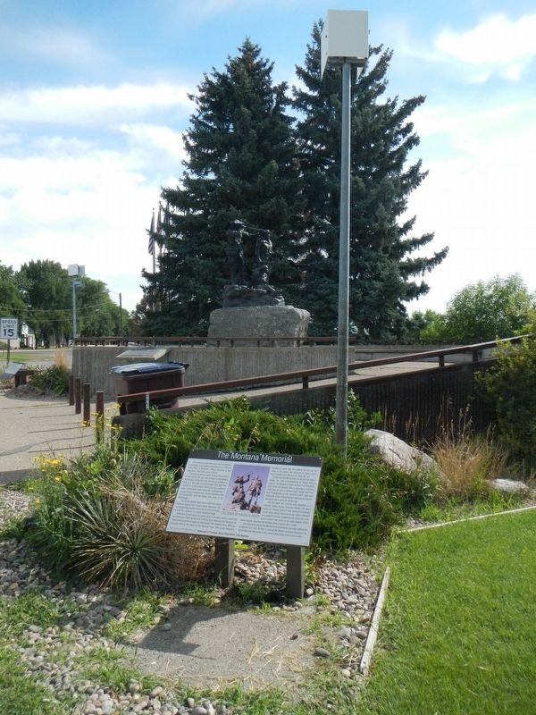
The Lewis and Clark Memorial was Fort Benton's contribution to the Nation's Bicentennial in 1976 and is the State of Montana's official memorial to the Expedition. Total cost was $175,000.
The statue is heroic-sized (1/6 larger than actual). It . . . — — Map (db m142244) HM
Back from the levee that was cluttered with their freight and warehouses stood the uptown merchant's establishments. Carroll and Steell founded the first mercantile in 1864. Murphy, Neil and Co., Kleinschmidt Bros. and W.S. Wetzel built here as well . . . — — Map (db m161658) HM
In Memory
of over 4000 U.S. Military working
dogs that served in the Vietnam War
when the war was over these dogs were
left behind in Vietnam, Thailand,
Laos and Cambodia
(back)
In Memory of over 4000 U.S. . . . — — Map (db m142169) WM
After the days of the gold rush, the most important trade route from Fort Benton was the Whoop Up Trail. Begun during the whiskey trade, it developed into the major supply route to Alberta and much of Saskatchewan. Whiskey traders carried their . . . — — Map (db m161588) HM
North from Fort Benton ran another wagon road to Canada, the famous Whoop-up Trail. Whiskey traders carried supplies north and brought buffalo robes south to Fort Benton for transport down river by steamboat. Later the Whoop-up Trail supplied the . . . — — Map (db m142018) HM
The Missouri River once flowed northeasterly through this valley to Hudson Bay. During the Bull Lake Ice Age, an ice dam near Loma diverted the river into its current channel. This channel began filling with glacial sediment, preventing the river . . . — — Map (db m142526) HM
On the evening of June 2, 1805 the Corps of Discovery arrived at the mouth of an unknown river flowing from the north. The river had not been mentioned by the Hidatsa nor was it noted on their maps. The two rivers were equal is size. Which was the . . . — — Map (db m142527) HM
The Lewis and Clark Expedition camped at the confluence of the Marias and Missouri rivers on June 2-12, 1805. The long stay allowed the group to rest and contemplate a dilemma. Which river flowed over the "Great Falls" described by the Mandan . . . — — Map (db m161801) HM
The Lewis and Clark Expedition camped at the confluence of the Marias and Missouri rivers on June 2-12, 1805. The long stay allowed the group to rest and contemplate a dilemma. Which river flowed over the "Great Falls" described by the Mandan . . . — — Map (db m161805) HM
Meriwether Lewis climbed up the drainage for their camp at the mouth of the Marias, where he reached a "commanding eminence" (where you are standing) and described the North Mountains (Bears Paw Mountains) and "the Barn Mountain (Square Butte). He . . . — — Map (db m142528) HM
Led by James Kipp, 75 employees of the American Fur Company arrived at the Marias in 1831 to build a post for trade with the Piegan Indians. They soon encountered a large party of Piegan, and Kipp staved off trouble by persuading the chiefs to . . . — — Map (db m161804) HM
The Lewis and Clark Expedition camped at the mouth of the river just east of here June 3, 1805. The Piegan people called it "The River that Scolds at all Others," but Lewis named it Maria's River in honor of his cousin, Miss Maria Wood (over time . . . — — Map (db m142488) HM
As envisioned, the City of Ophir was to rival Fort Benton. It was to have ferries across the Missouri River, warehouses, docks, wharves, wagon routes, and a few associated businesses. Construction began in 1865, Soon, 400 lots had been surveyed and . . . — — Map (db m161802) HM
The railroad grade you see before you was the St. Paul, Minneapolis and Manitoba Railroad, the precursor of the Great Northern Railway. In 1887, nearly 9,000 men constructed 550 miles of track across Montana's northern Great Plains between Minot and . . . — — Map (db m142486) HM
Erected by J.H. Friend's Family Descendants of Franklin Friend
for the
Victims of Blood Indian Massacre May 25, 1865
Franklin Friend - George W. Friend
Abraham Lotts - John Alley
John Andrews - N.W. Burris
Frank Angeline - Henry . . . — — Map (db m142490) HM
Below Morony Dam, the Missouri River runs free for more than 200 river miles, past Fort Benton and through the White Cliffs, much as it did in 1805.
(arrow pointing to:) Lower Portage Camp, beyond view, was located one mile . . . — — Map (db m282897) HM
(Three panels make up this marker; the center panel contains only hiking trail information) Land of Many Uses
When Lewis and Clark passed this way in 1805, they met no people but for thousands of years Indian lodges . . . — — Map (db m282901) HM
The mouth of Portage Creek served as a gateway to the portage around the rapids and waterfalls to the Missouri River. Undeterred by the obstacles, the men labored to begin the arduous portage.
At Lower Portage Camp, the men stashed the white . . . — — Map (db m282815) HM
On June 16, 1805, Captain Lewis, returning from his reconnoiter of the falls, rejoined Captain Clark downriver from here and "found the Indian woman extreemly ill and much reduced by her indisposition." Having walked by this spring . . . — — Map (db m282817) HM
For thousands of years Indians camped near the spring while on hunting forays. Their lodges dotted the prairie, and warriors stood sentry along the bluff on the lookout for intruders. When the tribes moved on, deer and birds quietly drank from the . . . — — Map (db m282813) HM
Coal Banks Landing takes its name from the dark layer of lignite coal in the hillsides. The landing was used by steamboats during the Indian War of 1876-77 and the construction of Fort Assinniboine on the northwest side of the Bears Paw . . . — — Map (db m161806) HM
Homesteaders, travelers, and railroad crews helped the tiny town of Virgelle thrive during the 1910s. Town founder Virgil Blankenbaker chartered the Virgelle State Bank in 1917 where he, his brother-in-law John G. Chancellor, C. J. McNamara, and . . . — — Map (db m161664) HM
Virgil F. Blankenbaker was among the first to homestead this areas when former Indian Reservation lands along the Missouri River opened to settlement in 1889. He accumulated miles of land across the plains and along the riverfront. Blankenbaker's . . . — — Map (db m161665) HM
Contractor John Holm constructed this small two-story building for the Dion family in 1929 after he had remodeled the Dion Block on one side and built the J.C. Penney Building on the other. This final addition to the five-building Dion Block shares . . . — — Map (db m163465) HM
he Northern Pacific Railroad platted the townsite of Glendive in 1882 against the arid Montana “badlands.” The location was an ideal supply and distribution center since it was where the railroad first met the Yellowstone River, but . . . — — Map (db m163580) HM
Rancher and banker Charles Krug came west from Ohio in 1878, searching for opportunity and a climate to relieve his sister Emma’s asthma. In 1881, he and Emma settled in Glendive where she was a seamstress and he worked for the railroad. Krug built . . . — — Map (db m163564) HM
"On our return we shal probably pass down the yellow stone river, which from Indian informations, waters one of the fairest portions of this continent." — Captain Meriwether Lewis, letter to President Thomas Jefferson, dated April . . . — — Map (db m202998) HM
1917 American Legion 1919
For God and Country
This Tablet Is Erected
In Honor Of
The Eight Hundred Ten Boys
of Dawson County Montana
Who Answered Their Country's Call
In The World War
and
In Memory Of . . . — — Map (db m163463) WM
Henry Dion built this brick building circa 1894 to expand his mercantile business. In 1908, he sold it to his two eldest sons, Harry N. and Fred. The brothers enlarged the original one-story building in 1910, adding a second story with apartments . . . — — Map (db m163802) HM
Fire swept through Glendive’s wood-frame businesses in January of 1886, destroying Henry Dion’s saloon and general merchandise, established on this corner in 1881. Dion constructed a kiln and built a more substantial fire- resistant brick building, . . . — — Map (db m163464) HM
Horses, Canoes and Bull Boats Clark and his party traveled by horse along the north side of the Yellowstone River until July 24, when nine members began a float in two lashed-together canoes built from cottonwoods they found along the river. . . . — — Map (db m202999) HM
Noted Miles City architect Brynjulf Rivenes designed this splendid English Gothic style church in 1909. Constructed under Pastor T. S. Leland during intense community growth brought about by homestead settlement, the building replaced the smaller . . . — — Map (db m163801) HM
A yachting party consisting of Capt. Wm. Clark, of the Lewis and Clark Expedition, six of his men, Sacajawea and her child flood by here August 1, 1806, navigating a craft made by lashing together two hollowed-out cottonwood logs. It was Clark's . . . — — Map (db m163815) HM
On this day, nearly 3 inches of rain fell in Glendive as an immense downpour. It folded the main streets of the city, covering the sidewalks to and average depth of 10 inches and causing damage to the businesses along Merrill Avenue. The ground . . . — — Map (db m163563) HM
(three panels on a common support are present top to bottom)
April, 7, 1899
On this day, ice on the Yellowstone River broke free sending large slabs of ice against the piers of the Yellowstone River Bridge. The ice gorged . . . — — Map (db m163581) HM
Fancy arches and other fine detailing highlight the façade of this commercial building, constructed as an investment in 1905 by pioneer Henry Dion. The outer walls are of softer, locally produced “Glendive brick” while quality imported . . . — — Map (db m163803) HM
After the death of Glendive pioneer Henry Dion in 1920, his widow and children contracted with John Holm to construct this commercial building according to the specifications of the J.C. Penney Company. Built in 1929, the architecture is typical of . . . — — Map (db m163560) HM
Neoclassical style elements including pilasters with decorative capitals and an elegant bracketed cornice enliven the facade of this significant building designed by Miles City architect Brynjulf Rivenes in 1910. Constructed by Joseph Wester for . . . — — Map (db m252904) HM
NSDAR
Real Daughter
Orpha Parke
Bovee
National No. 87088
Daughter of Ruben Parke
Revolutionary War Soldier
Connecticut.
Marker placed by
Montana State Society
NSDAR 2011
[Engraving on the stone:]
Orpha Z . . . — — Map (db m241977) HM
July 28, 1806 "Set out this morning at day light and proceeded on glideing down this Smooth Stream passing maney Isld...." July 29, 1806 "in the fore part of the day, I saw great numbers of Buffalow on the banks, … great . . . — — Map (db m203054) HM
he Catholics of Glendive first organized at St. Juliana’s, a 100-seat church purchased from the Congregationalists in 1886. After nearly forty years, they had outgrown those quarters. In 1924, architect Brynjulf Rivenes of Miles City designed a new . . . — — Map (db m163584) HM
Missionary Narcissa Whitman was recored to be the first white woman to cross the Rockies on the Oregon Trail. She and her husband Dr. Marcus Whitman settled near Walla Walla, Washington.
I chose to depict her at the river's edge in 1839, grief . . . — — Map (db m163808) HM
Striking red rock caps may of the hills of eastern Montana. Some of the rock looks volcanic, so it has incorrect; u been called scoria. Lewis and Clark attributed the red rock to burning coal beds and called the red areas "burnt hills." . . . — — Map (db m163875) HM
Interstate 90 (sic) generally follows the Yellowstone River from Glendive to Livingston, Montana. This river originates south of Yellowstone National Park and terminates when it joins the Missouri River north of here. It is the longest undammed . . . — — Map (db m163818) HM
In the fall of 1909, a Great Northern Railway survey crew came through here and by 1912 all of the surrounding area had been homesteaded except the badlands. Those early years were hard on the settlers. In spite of the survey, there were no . . . — — Map (db m143260) HM
Alexander “Nosey” D. Smith came to Havre as a Great Northern Railroad conductor when the first trains came through town in the mid-1890s. He purchased two lots for $5 in 1897 and built this late Victorian Folk style home in 1902. . . . — — Map (db m142676) HM
The sunburst motif on the front gable end of this single-story, hipped-roof residence signals the builder’s debt to the Queen Anne style. Havre pioneer Daniel H. Boone and his wife, Elizabeth, owned the four-square residence. Built before 1903 and . . . — — Map (db m142675) HM
A battlement-topped octagonal turret—a traditional military architectural symbol—distinguishes Fort Assinniboine’s Company Officers’ Quarters. Built in 1880 under supervision of Major J. C. C. Lee, the six-unit building asserted . . . — — Map (db m142742) HM
A row of thirteen mansard-roofed officer's quarters, flanked by two flat-roofed apartment buildings, defined the north east side of the parade grounds. Ten of the buildings were duplexes, most like this one, designed to house married officers and . . . — — Map (db m142798) HM
Prominent builder Abe Crosson acquired this property in 1911. By 1916, a booster brochure proclaimed the frame Colonial Revival residence one of Havre’s beautiful homes. In 1936, Great Northern Railroad conductor Ray VanBuskirk and his Irish-born . . . — — Map (db m252319) HM
Fort Assiniboine, guardian of Montana's frontier, was established by act of Congress in May, 1878. Lt. Colonel Brooks selected this high site on Beaver Creek and superintended the million-dollar construction of the the fort, which took . . . — — Map (db m270965) HM
Established in 1879, Fort Assinniboine was one of the most strategically-placed U.S. Army posts in the northwest. Headquarters for the District of Montana, the fort and military reserve encompassed the entire Bears Paw mountain range. The 18th U.S. . . . — — Map (db m142594) HM
Montana's largest and most impressive military post was established in 1879 in the aftermath of the defeat of Colonel Custer and the Seventh Cavalry by the Sioux (Lakota) Nation at the Battle of the Little Bighorn River and the capture of the Nez . . . — — Map (db m142771) HM
According to the United States War Department, Fort Assinniboine was established in 1879 “for the purpose of protecting the citizens of Montana from the hostile incursions of Indian tribes dwelling in that region; and especially ... the Sioux . . . — — Map (db m142772) HM
With its graceful dormer and full-length front porch supported by Tuscan columns, the front of this one-story, hipped-roof building looks like an attractive and comfortable residence. The back of the building, with its small, arched barred windows . . . — — Map (db m142774) HM
Cowpunchers, miners, and soldiers are tolerably virile person as a rule. When the went to town in the frontier days seeking surcease from vocational cares and solace in the cup that cheers it was just a well for the urbanites to either brace . . . — — Map (db m142640) HM
Red brick, finely crafted stonework, and a colonnade reminiscent of a Greek temple brought an imposing federal symbol to Havre in the 1930s. Securing state and federal funds for this post office was an expression of optimism during economic . . . — — Map (db m142645) HM
The post’s first library was relegated to a small space at the back of the Signal Corps office, but in 1888-89 the military spent $1,409.13 to build a one-story, brick, hipped-roof library with multiple wings. A visiting Helena reporter called the . . . — — Map (db m142773) HM
The quintessential businessman, Lou Lucke arrived in Havre in 1903, where he founded a shoe repair and later a clothing store and a dry cleaning business. He also speculated in real estate. When the homestead boom in turn boomed Havre, Lou and local . . . — — Map (db m142672) HM
In its final years as a military outpost in 1904 and 1905, Fort Assinniboine underwent an extensive effort to expand and modernize its facilities. Great Falls contractors Frank Coombs and Duncan Brothers built this residential duplex in 1905 for . . . — — Map (db m142679) HM
In its final years as a military outpost in 1904 and 1905, Fort Assinniboine underwent an extensive effort to expand and modernize its facilities. Great Falls contractors Frank Coombs and Duncan Brothers built this residential duplex in 1905 for . . . — — Map (db m142741) HM
Frontier capitalist C. A. Broadwater received the contract to provide locally manufactured bricks and timber, hauled from the Bear’s Paw Mountains, to construct Fort Assinniboine. He hired five hundred Métis (mixed-blood Chippewa-Cree) from the . . . — — Map (db m142775) HM
Before refrigeration, rural Americans preserved perishables in root cellars. The fort’s first root cellar, a 100-by-20- foot structure, was built in 1879-80. In 1902 the government invested $3,900 (about $237,000 in 2011 dollars) to replace the . . . — — Map (db m142799) HM
Havre's first Episcopal church service was held in 1900 at Fort Assinniboine, south of Havre. After the arrival of the Reverend Leonard J. Christler in 1907, regular services were conducted in town. The Reverend Christler immediately began plans for . . . — — Map (db m252321) HM
Havre's first Episcopal church service was held in 1900 at Fort Assiniboine, south of Havre. After the arrival of the Reverend Leonard J. Christler in 1907, regular services were conducted in town. The Reverend Christler immediately began plans for . . . — — Map (db m142671) HM
This building once stood as home for the famed Buttrey retail store. This store brought shoppers from all over Montana and Canada to the area. Created by Frank Buttrey, the store began as a small shop called "The Fair" in 1902. The store, which . . . — — Map (db m142595) HM
African American soldiers serve in the Revolutionary War, and fought for the Union in the American Civil War. Six black cavalry-infantry units were officially organized on September 21, 1866 at Fort Leavenworth, Kansas. These men saw service . . . — — Map (db m142745) HM
After the Soviet Union's detonation of an atomic bomb in 1949 and the beginning of the Korean War in 1950, tensions mounted between the United States and the USSR. To prevent a surprise attack, the US Air Force established a radar network to . . . — — Map (db m142639) HM
Indian people have lived in this area for at least 11,000 years. Throughout that time, buffalo were their primary source of food. The Indians devised ingenious way to hunt buffalo with the buffalo jump, or pishkum, the best known. At pishkuns, . . . — — Map (db m142644) HM
Immense herds of bison once roamed the great North American prairies. As many as 30 million of the great shaggy beasts moved seasonally in herds of 25 to 300, following the same patterns year after year. Bison, or buffalo, were the lifeblood of the . . . — — Map (db m142638) HM
In Honor of Those Who Answered Their Country's Call in World War II
This Community Dedicates This Memorial
1941 - 1945
"This prayer we make in penitence that all who pass by here may sense the costliness of human strife , the . . . — — Map (db m142911) WM
Many Indian people believe that spirits dwell in north central Montana's "island" mountains: the Sweet Grass Hills and the Bear Paw and Little Rocky ranges. Their rugged peaks, clustered like tepees in a camp, offer access to the supernatural and . . . — — Map (db m162053) HM
Many Indian people believe that spirits dwell in north central Montana's "island" mountains: the Sweet Grass Hills and the Bear Paw and Little Rocky ranges. Their rugged peaks, clustered like tepees in a camp, offer access to the supernatural and . . . — — Map (db m162055) HM
Many a dogie # (not doggie - dudes please note) has been decorated with one of these famous Montana irons.
(Click on the photograph to enlarge it and have a closer look at the brands.)
# A dogie is a little calf who has lost . . . — — Map (db m142884) HM
The old West produced some tolerably lurid gunslingers.
Their hole card was a single-action frontier model .45 Colt, and their long suit was fanning it a split second quicker than similarly inclined gents. This talent sometimes postponed . . . — — Map (db m142883) HM
Malta, first known as “Siding 54,” took its place along the Hi-Line in 1887 as the Great Northern Railway opened new opportunities. The railroad heavily promoted the area, and by 1910, Malta was the county seat. Longtime residents Lee Edwards and . . . — — Map (db m252324) HM
Montana's native people revere this boulder that once perched high atop a wind-swept ridge overlooking the Cree Crossing on the Milk River. The ancient weather-worn effigy resembled the leader of a herd of reclining buffalo in an outcrop of gray . . . — — Map (db m142885) HM
In 1919, the Duluth, Minnesota Chamber of Commerce sponsored the creation of the Theodore Roosevelt International Highway as a memorial to the recent passing of the former president. An early interstate highway, the route stretched 4,000 miles . . . — — Map (db m142887) HM
The Missouri River once flowed through this valley as it made its way northeasterly to Hudson's Bay. A gigantic ice dam diverted the Missouri to its current channel about 15,000 years ago. The Milk River occupies the old channel and flows through a . . . — — Map (db m292056) HM
The service station industry was still in its infancy when businessman H. Earl Clack began building a network of retail gasoline and bulk oil outlets across the northern plains into the Pacific Northwest. His company headquarters were in Havre, and . . . — — Map (db m142925) HM
In the Larb Hills south of Saco on the spring roundup of 1904 the cowhands of the "Square" and "DHS" cow outfits successfully lassoed and killed a large grizzly bear. Joe Reynolds skillfully rope artist from the Long X lassoed its hind paw and . . . — — Map (db m142931) HM
…near Fairview began as early as the 1860's. N.W. of here on the Fairview Hill, the Jennison Mine Mining lignite coal began underground mining in 1913.
Each shift of 30 men could produce up to 125 tons per day, shipping coal as far as . . . — — Map (db m162115) HM
The Burgess Garage was constructed circa 1913 and is the oldest building standing in Lambert. That year the Northwest Improvement Company, a subsidiary of the Northern Pacific Railroad, platted the new townsite. Business at the garage (then called . . . — — Map (db m143241) HM
Northeastern Montana is part of the Williston Basin geologic structure, a slightly irregular, bowl-shaped depression centered in North Dakota that slowly subsided over hundreds of millions of years. It served as a locus for sediment accumulation, . . . — — Map (db m203000) HM
Fort Union, one of the largest and best known trading posts in the American West, was located on the Missouri near the mouth of the Yellowstone, about 14 miles southeast of here. Built in 1828, it was the headquarters for the American Fur Company’s . . . — — Map (db m142983) HM
These coal mine cars were used in the Jennison/Wix Mine from 1941 until it closed in 1959. This mine was the largest mine in the Girard Coal Field. The twelve foot thick coal vein produced a low quality lignite coal, which was sold for domestic use . . . — — Map (db m308783) HM
The Fort Union Formation was deposited not long after the dinosaur extinction, about 65 million years ago. Rivers originating in mountains to the west and south carried abundant sediment to the nearby shallow inland sea to the east, crossing the . . . — — Map (db m142979) HM
From little towns in a far land we came to our honor and a world aflame. By little towns in a far land we sleep and trust those things we won to you to keep. —Rudyard Kipling [left panel] Culbertson Earl Morrow WWI • . . . — — Map (db m308792) WM
Wherever you are in Montana, you stand in the pathway of Lewis and Clark. Their 1804-1806 expedition was a grand adventure to investigate the people and resources of the newly acquired Louisiana Purchase and to seek a navigable passage across the . . . — — Map (db m142981) HM
Fort Peck Indian Reservation is the home of two tribes, the Assiniboines, whose forefathers were living in this vicinity when Lewis and Clark came up the Missouri in 1805, and the Dakota (Sioux) descendants of the "hostiles" who fiercely . . . — — Map (db m142978) HM
Roll of Honor Indian Soldiers Who Died in Military Service Abbott, Sgt. Donald Ackerman, Pvt. Ray Archdale, S/Sgt. Percy J. Bauer, T/Sgt. Frederick (2) Bow, Pvt. Henry Connor, Pvt. Fred Crazy Bull, Pvt. Nathan (2) Dupree, Capt. . . . — — Map (db m203076) WM
Over there...
This location has long been an important river crossing. Buffalo herds used it for centuries. The Assiniboine named it "Crow Ford" because the Crow used it during their raiding campaign. Ferries operated at this location from . . . — — Map (db m142949) HM
The second in a series of Centennial Acres was donated in 1986 by Montana's First Lady, Jean Schwinden, and her brother Julius Christianson. Located where their immigrant parents, Nels and Amanda Christianson, settled in 1913, the site is . . . — — Map (db m202997) HM
The Wolf Point Bridge was the result of many years of lobbying by Roosevelt and McCone county citizens led by Wolf Point businessman William Young. In 1927, the Montana Highway Commission and Bureau of Public Roads approved the project. The . . . — — Map (db m142977) HM
The Lewis and Clark Expedition passed by here, westward bound, in May, 1805. Fur trappers and traders followed them a few years later. Steamboats began making it from St. Louis up the Missouri as far as Fort Benton in the early 1860s. Wolf Point was . . . — — Map (db m142947) HM
As workers poured in to work on Fort Peck Dam, the population of this quiet area boomed.
Barracks and dormitories were built in Fort Peck to house individual workers, but families had nowhere to live. More than 20 boomtowns sprang up just . . . — — Map (db m162092) HM
The largest hydraulically filled dam in the world, Fort Peck Dan was made from a slurry of sand, silt, clay, and gravel dredged from the Missouri River.
Nearly four miles long, the dam needed over 125 million cubic yards of . . . — — Map (db m162113) HM