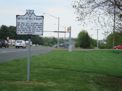
On James Monroe Highway (U.S. 15) at Battlefield Parkway, on the right when traveling south on James Monroe Highway. Reported missing.
One mile east occurred the Battle of Ball’s Bluff, October 21, 1861. A Union force, which had crossed the river at this point, was driven back over it by the Confederates. — — Map (db m985) HM
On Viewpoint Road 0.6 kilometers north of Township Road 452 when traveling west.
West of Wainwright the railway met a deep challenge, a glorious valley that was home to the Battle River. In 1907, the concrete footings of the bridge that would span the valley were poured. Farmers and other contractors hauled supplies to the site . . . — — Map (db m197037) HM
On Longwoods Road (County Route 2), on the right when traveling east.
In September 1813, during the second year of the War of 1812, the United States won control of Lake Erie, cutting British supply lines with the east and forcing the British to withdraw from the Detroit River region. Then, on October 5, . . . — — Map (db m78367) HM
On Kijkduinstraat, on the right when traveling north.
Tijdens de laatste grote slag van de Derde
Engels-Nederlandse Oorlog verslaat op 21
augustus 1673 de Nederlandse vloot, onder
bevel van luitenant-admiraal-generaal Michiel
de Ruyter, de Frans-Engelse vloot bij Kijkduin.
Deze slag . . . — — Map (db m210604) HM
On Fourche Dam Pike at East Roosevelt Road, on the left when traveling south on Fourche Dam Pike.
In this vicinity, on September 10, 1863, an invading Federal column under Gen'l Frederick Steele defeated Confederate forces under Gen'l John Marmaduke in the Battle of Little Rock — — Map (db m116460) HM
On East Douglas Street (U.S. 62), on the right when traveling west on East Douglas Street.
The battle on this field was fought between the Confederate army of General T.C. Hindman (Arkansas) and Federal forces commanded by Generals James G. Blunt (Kansas) and F.J. Herron (Iowa). Battlefield Park occupies the approximate center of the . . . — — Map (db m35248) HM
On West Main Street (Arkansas Route 38) east of Elm, on the right when traveling east.
July 7, 1862, the 11th Wisconsin Infantry of the Federals, commanded by Colonel Hovey, met the Confederate Texas Cavalry commanded by General Rust at Hills Plantation and engaged in a bitter fight.
The Battle of Cache River or Cotton Plant is . . . — — Map (db m116454) HM
The chief engagement of Connecticut’s only inland battle during the War for Independence was fought approximately 100 yards from this site. Several hundred hastily-mustered militia joined a handful of Continental troops under Generals Benedict . . . — — Map (db m23400) HM
Near Resaca Lafayette Road Northwest (Georgia Route 136).
A French scientist invented photography in 1832. By 1861, the beginning of the Civil War, photography had progressed a great deal. However, photographers still created images mostly on glass (daguerreotype) or tin (tintype). Each image took a long . . . — — Map (db m170993) HM
On Curran Road just west of Morris Avenue, on the right when traveling west.
History has recorded the Battle of Kansas as an all-out effort by the US Army Air Forces to get a combat-ready fleet of B-29s overseas to bomb Japan and destroy the factories that fueled its war effort. The battle to renovate the B-29s was fought . . . — — Map (db m230188) HM
On Dunker Church Road north of Sharpsburg Pike (Maryland Route 65), on the right when traveling north.
Confederate and Federal forces clashed at the Battle of Antietam on September 17, 1862, transforming the local community and the nation. Sharpsburg families hid from the carnage, suffering damage to their homes and farms. Bodies and bullets . . . — — Map (db m247691) HM
On Clark Avenue west of South Broadway, on the right when traveling west.
1764 - St. Louis is founded by Pierre Laclede Liguest and Auguste Chouteau under a land grant from the King of France.
1770 - Control of St. Louis is transferred from France to Spain.
1779 - Spain supports the Americans in their pursuit . . . — — Map (db m219670) HM
On New York Road (U.S. 9) at Chestnut Neck Road (County Route 575), on the right when traveling north on New York Road.
In honor of the Brave Patriots of the Revolutionary War who defended their liberties and their homes in a battle fought near this site October 6, 1778 ---------- Dedicated October 6, 1911 Lower Plaque: Erected by the State of New Jersey . . . — — Map (db m10811) WM
On Stockton Street at Bayard Street on Stockton Street.
Here memory lingers to recall the guiding mind whose daring plan outflanked the foe and turned dismay to hope when Washington, with swift resolve, marched through the night to fight at dawn and venture all in one victorious battle for our freedom. . . . — — Map (db m5379) HM
On Sheridan Loop, on the right when traveling east.
In the summer of 1776 this site saw both the first coast defense of the newborn United States & the opening of the largest battle of the Revolutionary War. On that original Fourth of July, a small American gun position near here entered into an . . . — — Map (db m21612) HM
On Battle Avenue at Border Avenue, on the left when traveling north on Battle Avenue.
On July 4, 1776, the United States issued its Declaration of Independence from Great Britain. As the summer progressed, General George Washington and his Continental Army held Brooklyn and New York City, while the British gathered their forces on . . . — — Map (db m69530) HM
Accounts of the naval action during the Battle of Fort Montgomery are conflicting. This scene is one impression of how the river might have looked during the battle.
"The Shark and Cambden were ordered on the east side of the river to defend the . . . — — Map (db m7556) HM
On Interstate 87, on the right when traveling south.
One of the most decisive battles in world history ended with the surrender near here of the British army invading from Canada under General “Gentleman Johnny” Burgoyne in 1777. The defeat ended a summer-long campaign by over 7,000 British, Hessian . . . — — Map (db m56850) HM
On Broadway (U.S. 9) at Edgar's Lane, on the right when traveling north on Broadway.
Sept. 30, 1778 Continental Dragoons Under Maj. Henry Lee killed 23 Hessians on a Marauding Expedition. Battle Waged from Here to Ravine — — Map (db m237827) HM
On State Highway 82 at Magruder Road, on the right when traveling north on State Highway 82.
You are standing at the center of the second phase of fighting in the Battle of Averasboro, March 15,16, 1865. On the morning of March 16th, after the fight of the preceding afternoon around John Smith’s house 2 miles south on this road, Union . . . — — Map (db m5833) HM
On East McElroy Road 0.3 miles State Highway 18, on the left when traveling west.
Here between the landmark known as Round Mountains to the south and a camp on Salt Creek three miles to the northwest was fought the first battle of the Civil War in Oklahoma.
When the five civilized tribes of the Indian Territory joined the . . . — — Map (db m209523) HM
Near Monument Avenue, on the left when traveling west.
The land on which the Battle of Paoli was fought has been farmland and woodland since the mid-18th century. Ezekiel Bowen, a farmer of Welsh descent, purchased this land in 1764. County records note that he sold it to Richard Mason of Philadelphia . . . — — Map (db m13619) HM
On Columbia Avenue (Business U.S. 31) at Everbright Avenue, on the left when traveling north on Columbia Avenue.
Front:
Founded in 1889 as Battle Ground Academy, the first campus was located on the foundation of the Carter Cotton Gin on Cleburne Street, the epicenter of the Battle of Franklin in 1864. BGA, founded on the principles of Character, . . . — — Map (db m146536) HM
The harsh anti-Indian policies of President Mirabeau B. Lamar and Mexican efforts to weaken the Republic of Texas stirred Indian hostilities. Hatred increased after the Council House Fight in San Antonio, March 19, 1840, where 12 Comanche chiefs . . . — — Map (db m64063) HM
Near Parker Lane, on the left when traveling north. Reported missing.
(Preface): In June 1864, Confederate Gen. Robert E. Lee sent Gen. Jubal A. Early's corps from the Richmond battlefields to the Shenandoah Valley to counter Union Gen. David Hunter's army. After driving Hunter into West Virginia, Early . . . — — Map (db m133228) HM
Near Redbud Road (County Route 661), on the right when traveling east. Reported permanently removed.
You are standing near the center of General Early's infantry line at what has come to be called the West Woods. Although these particular trees were not here during the Battle of Third Winchester, some are in the same location as those that stood on . . . — — Map (db m159425) HM
Near Redbud Road (Virginia Route 661) 0.9 miles east of Martinsburg Pike (U.S. 11), on the right when traveling east. Reported permanently removed.
(left panel)
Shenandoah At War
In 1996, Congress designated eight counties as the Shenandoah Valley Battlefields National Historic District, with a mission to preserve and interpret the region's Civil War battlefields and related . . . — — Map (db m155070) HM
On Hayes Road (County Road 1216) at Hook Road (County Road 1219), on the right when traveling north on Hayes Road.
Here at the Hook on October 3rd, 1781, in the largest cavalry action of the American War of Independence, the Duc du Lauzun's Legion and Lieutenant Colonel John Mercer's Select Battalion of Militia defeated Lieutenant Colonel Banastre Tarleton's . . . — — Map (db m167803) HM
Near Powhatan Drive west of Pigeon Hill Road, on the right when traveling west.
The Volontaires-étrangers de Lauzun
The Foreign Volunteers of Lauzun
Lauzun's Legion was created on March 5, 1780, expressly for him, and numbered around 600 men during the American Campaign. It was considered part of the French . . . — — Map (db m310614) HM
On Cold Harbor Road (Virginia Route 156) at Fast Lane, on the right when traveling east on Cold Harbor Road.
The Civil War battle of Beaver Dam Creek (Mechanicsville) began on the afternoon of 26 June 1862. Confederate Maj. Gen. Ambrose P. Hill’s division crossed the Chickahominy upstream at Meadow Bridges and encountered Union skirmishers. The Federals . . . — — Map (db m14988) HM
Near Cold Harbor Road (State Highway 156) 0.2 miles east of Boatswain Lane, on the right when traveling east.
All the visible remains along the trail date from the June 1864, Battle of Cold Harbor, but this ground figured prominently in the Seven Days campaign of 1862 as well. On June 27, 1862, General Thomas J. “Stonewall” Jackson’s Confederates . . . — — Map (db m16202) HM
On Willis Church Road (Virginia Route 156) at Charles City Road, on the left when traveling north on Willis Church Road.
Willis Church Road runs from here to Malvern Hill. A large part of Union Gen. George B. McClellan’s Army of the Potomac followed this road south toward the James River, four miles ahead, near the end of the Seven Days’ Battles in 1862. On 30 June, . . . — — Map (db m15061) HM
On Constitution Way, on the left when traveling east.
A stalwart defense of the Warwick River by units of the 15th North Carolina, 7th Georgia and 2nd Louisiana Infantry, C.S.A., commanded by General J.B. Magruder is commemorated here. The defensive line extending across the Virginia Peninsula was held . . . — — Map (db m10340) HM
On Hill-Ewell Drive at Constitution Highway ( Route 20), on the left when traveling south on Hill-Ewell Drive.
Here May 5, 6, 1864, 70,000 Confederates under Lee defeated 120,000 Federals under Grant. Confederate loss 11,500. Federal 18,000. This battle, fought with conspicuous bravery, in a Wilderness on fire, will take it’s place among the great battles of . . . — — Map (db m6007) HM
On Pocahontas Trail (U.S. 60) at Avon Avenue, on the right when traveling east on Pocahontas Trail.
The Battle of Williamsburg, fought on 5 May 1862, was the first major engagement of the Peninsula Campaign. Union Maj. Gen. George B. McClellan, slowly advancing from Hampton Roads toward Richmond, encountered the rear guard of Confederate Gen. . . . — — Map (db m166339) HM
On Battlefield Trail at U.S. 90, on the right when traveling west on Battlefield Trail.
(Front):The Battle of Olustee was fought on this ground February 20th, 1864. Between 5,000 Confederate troops commanded by General Joseph E. Finegan and 6,000 Federal troops under General Truman Seymour. The Federals were defeated with a loss . . . — — Map (db m13708) HM
S. S. James Oglethorpe launched on November 20, 1942, during World War II, the first of 88 Liberty Ships
built by Southeastern Shipbuilding (approximately two miles downriver from here). Setting sail from New York in a convoy bound for Liverpool, . . . — — Map (db m65470) HM
On Frederica Road 0.1 miles east of Stevens Road, on the right when traveling west.
During the late morning of July 7, 1742 Georgia Rangers guarding the military road approach to the town of Frederica sighted a force of over 100 Spanish soldiers and their Indian allies. James Edward
Oglethorpe, founder of Georgia, quickly . . . — — Map (db m11634) HM
On Baker Valley Road, on the right when traveling south. Reported missing.
The Battle of Monocacy changed from a stalemate to a rout as the final lines of Maj. Gen. John B. Gordon's three Confederate brigades swept down Brooks Hill onto the fields of Thomas farm. Both sides traded blistering gunfire around the Thomas . . . — — Map (db m89985) HM
Near Annapolis Road (Maryland Route 450) at 46th Street.
On August 24, 1814, British forces broke camp at Melwood Park and moved northwest to Bladensburg. The Baltimore militia, under the command of General Tobias Stansbury, was positioned west of the Anacostia River along the Bladensburg-Washington Road . . . — — Map (db m6069) HM
On Whipholt Beach Road (Maple Leaf Drive) (State Highway 200) 0.4 miles east of 16th Avenue (Pine Lake Road) (County Road 2108), on the left when traveling east.
When a federal marshal with about 100 troops of the 3rd Infantry tried to arrest the Chippewa Chief Bugonaygeshig at Sugar Point opposite here on the northeast shore of the lake, a sharp fight occurred October 5, 1898. The whites lost 7 killed and . . . — — Map (db m124726) HM
While General Stevens’ division attacked the Confederates on this side of Ox Road, part of General Jesse Reno’s division entered the woods east of the road to protect Stevens’ flank and probe the Confederate line. Reno’s two leading regiments . . . — — Map (db m182241) HM
On Kelly's Ford Road (Virginia Route 674) at Kelly's Ford Road ( Route 620), on the right when traveling south on Kelly's Ford Road. Reported unreadable.
Civil War cavalry battles could be huge, shifting, sprawling engagements, spread across miles of countryside. For instance, the Battle of Brandy Station, named for a railroad town eight miles away, began at historic Kelly’s Ford in front of you. . . . — — Map (db m295567) HM
Near Constitution Highway (Virginia Route 20), on the left when traveling west.
Ellwood stood in the midst of the Wilderness, a dark, forbidding forest characterized by stunted trees and densely tangled undergrowth. When the Confederates challenged General Ulysses S. Grant’s advance through the Wilderness on May 5, 1864, the . . . — — Map (db m155694) HM
On Old Valley Pike (U.S. 11), on the right when traveling south.
After his defeat on 19 Sept. 1864 at the Third Battle of Winchester by Maj. Gen. Philip H. Sheridan, Lt. Gen. Jubal A. Early led his 9,500-man army here to Fisher's Hill, a favorite Confederate stronghold. Sheridan pursued, and on 22 Sept. attacked . . . — — Map (db m50313) HM
On Royal Avenue (U.S. 340) at Rocky Lane (County Route 607), on the right when traveling south on Royal Avenue.
Early on the morning of Friday, May 23, 1862, Gen. Thomas J. “Stonewall” Jackson paused here at Asbury Chapel well in advance of his 16,000-man army. Although he was familiar with the main roads to Front Royal, Jackson knew that the terrain through . . . — — Map (db m171036) HM
On East Main Street west of Blue Ridge Avenue, on the right when traveling west. Reported permanently removed.
On May 23, 1862, Front Royal was occupied by 1000 Federal troops (1st Maryland Infantry, 29th Pennsylvania and a battery of Knap’s Artillery) under the command of Col. J.R. Kenly.
In the early afternoon Confederate Gen. T.J. “Stonewall” . . . — — Map (db m256800) HM
On Prospect Avenue (County Road 27/1) at Whitman Avenue, on the left when traveling north on Prospect Avenue.
Battle of Harpers Ferry
Invasion rocked the United States during the second year of the American Civil War. In September 1862 Confederate General Robert E. Lee launched his army into Maryland - the North. Lee's first target became Harpers . . . — — Map (db m148862) HM
Near Boulevard Perron Ouest (Québec Route 132), on the left when traveling west.
English:
In May 1760 a French relief fleet, unable to reach Quebec, took refuge at the head of Chaleur Bay. It was there that a British squadron blockaded them on June 22. Aided by Acadians and Micmacs, the French planted batteries on . . . — — Map (db m80582) HM
On Battlefield Road 0.3 miles east of Green Street.
You are standing on the site of the last grand charge of the Civil War, made during the Battle of Fort Blakeley on April 9. 1865. The battle was the climax of a months-long campaign that led ultimately to the capture of the city of Mobile by Union . . . — — Map (db m131890) HM
On U.S. 82 at Pugh Circle, on the right when traveling west on U.S. 82.
It is the morning of June 6, 1864. Rain has created a muddy mess. To your left are four cannon. To your right are 600 cavalrymen and two more cannon. These men served under Confederate Colonel Colten Greene. To your front is Ditch Bayou, and 700 . . . — — Map (db m90432) HM
On U.S. 34 at County Highway J, on the right when traveling west on U.S. 34.
In September 1868 fifty civilian scouts left Fort Wallace, Kansas, to fight Cheyenne and Sioux warriors, on the theory that experienced frontiersmen could defeat any enemy force. On September 17 the scouts approached the Arikaree River, . . . — — Map (db m201049) HM
On Natural Bridge Road 6 miles east of Woodville Highway (State Highway 363), on the left when traveling east.
(south)In Loving Memory 1861-1865 Defenders of Natural Bridge Lest We Forget (east) This monument erected under authority of an act of the legislature of Florida of 1921 as a just tribute of the people of Florida to commemorate the . . . — — Map (db m157200) HM WM
On Buchanan Road at Blake Road, on the right when traveling east on Buchanan Road.
[Front top]: Dedicated to the Preservation of the Memory of Midway
where one of the most decisive naval battles in military history was fought
June 4, 1942
The day when the American Spirit reached unparalleled heights and, in so doing, . . . — — Map (db m6491) WM
On Marth Road (County Route 1002) near Cooper Road (County Route 5001), on the left when traveling west.
During the fall of 1862, Bates County had become a haven for guerrillas and Confederate recruiters. One of their favorite haunts was a marshy tract on the Marais-des-Cygnes River, southwest of Butler, known to locals as "Hog Island." On Oct. . . . — — Map (db m65050) HM
On Battle Avenue, on the right when traveling east.
The American Revolutionary War
1776 2001
Phases of Action
October 28th
Morning
1. Americans Occupy Chatterton’s Hill
2. British Approach from the South
3. American Pickets Retreat
4. Hessians Under Rahl Seize Hill
5. British . . . — — Map (db m8309) HM
On Ohio Route 124 0.1 miles south of Local Highway 153, on the right when traveling south.
(Front side):
On and near this spot, July 19, 1863, occurred what is known as the Battle of Buffington Island between the forces of Gen. John H. Morgan, Confederate leader, who was attempting to cross the river near the middle of the island . . . — — Map (db m35822) HM
On Old Number Six Highway (State Highway 6 / 45) at Fredcon Road, on the left when traveling east on Old Number Six Highway.
This stone marks the field whereon was fought the battle of Eutaw, September 8, 1781, between a force of the United States under Major General Nathanael Greene and a force of Great Britain under Colonel Stuart. Neither side was victorious, . . . — — Map (db m21759) HM WM
On Locks Road 0.6 miles west of North Battlefield Boulevard (Virginia Route 168), on the left when traveling west.
In the early morning of December 9, 1775, two opposing forces faced each other across the Great
Bridge, the British on the north end and the patriots to the south. The battle lasted about thirty minutes...but its outcome will last as long as . . . — — Map (db m211253) HM
On Sycamore Drive 0.1 miles south of Boydton Plank Road (U.S. 1), on the left when traveling south.
(front)
In Memoriam
Battle of Dinwiddie Court House
Dedicated to the Confederate and Union soldiers who gave their lives in the Battle of Dinwiddie Court House, sometimes called Chamberlain’s Bed, in the last brief victory of the . . . — — Map (db m17670) HM
On Valley Pike (U.S. 11) at Belle Grove Road, on the right when traveling south on Valley Pike.
General Philip Sheridan defeated General Jubal Early here for the third time in 30 days. Sheridan’s pursuit of Confederates from Fisher’s Hill halted at Mount Crawford. On his return he encamped his three corps in this immediate area. Early . . . — — Map (db m581) HM
On Getty Lane 0.2 miles Gateway Drive, on the left when traveling north.
(left panel)
Shenandoah At War
In 1996, Congress designated eight counties as the Shenandoah Valley Battlefields National Historic District, with a mission to preserve and interpret the region's Civil War battlefields and . . . — — Map (db m159423) HM
Near John Mosby Highway (U.S. 50) west of Zulla Road (Virginia Route 709), on the left when traveling west.
After Confederate Gen. Robert E. Lee’s stunning victory at Chancellorsville in May 1863, he led the Army of Northern Virginia west to the Shenandoah Valley, then north through central Maryland and across the Mason-Dixon Line into . . . — — Map (db m134765) HM
On Rich Mountain Road / Files Creek Road (County Route 37/8), on the right when traveling east.
The battle was fought in this pass along the Staunton-Parkersburg Turnpike. Union forces led by General William S. Rosecrans stormed down the hill behind you. Confederates on guard here took cover behind log breastworks, farm buildings and large . . . — — Map (db m23539) HM
On Old Camden Road 0.8 miles south of Marks Cemetery Road, on the left.
Battle of Marks' Mills
On April 23, 1864, a Union force with 240 wagons left Camden to get supplies from Pine Bluff for Gen. Frederick Steele's army. Gen. James Fagan's Confederate cavalrymen ambushed them at Marks' Mills on April 25. . . . — — Map (db m121150) HM
On Martin Luther King Boulevard (West Broad Street) at Louisville Road, on the right when traveling south on Martin Luther King Boulevard (West Broad Street).
The 1779 Battle of Savannah was one of
the deadliest of the entire American Revolution.
The overwhelming defeat of French and
American forces resulted in an allied
withdrawal and in approximately 800 wounded
or killed, with British losses . . . — — Map (db m189564) HM
On Harrington Road, on the right when traveling east.
The battle fought on the Lexington Common between the British and the Americans on April 19, 1775 was one of the first great events of the American Revolution. But for a century afterwards, residents paid no particular attention to their town . . . — — Map (db m18480) HM
On Old Wire Road at South Walnut Avenue, on the right when traveling west on Old Wire Road.
McCullock assigned Brig. Gen. James S. Rains and his six mounted companies of the 8th Division of the Missouri State Guard along with a company of Arkansans, about 400 men, to take the lead in the southern advance. Rains was given the task . . . — — Map (db m258752) HM
On Fort Craig Road 4.5 miles south of Old US Hwy 85 (New Mexico Highway 1).
You may be surprised to learn that a bloody confrontation of the Civil War was fought only a few miles from Fort Craig.
The main Battle of Valverde was fought in the winter on February 21, 1862. Colonel Edward Richard Sprigg Canby's Union . . . — — Map (db m253339) HM
On Old Waynesboro Road at Iron Springs Road, on the right when traveling north on Old Waynesboro Road.
Fountain Dale is located between Jack's Mountain and Beard's Hill, and is also connected to two major mountain gaps, Monterey Pass and Fairfield Gap, which would prove to be fighting ground all of it's own. Troops on both sides needed to keep the . . . — — Map (db m8512) HM
On Beverly Ford Road (County Route 677) at St. James Church Road (County Route 676) on Beverly Ford Road. Reported permanently removed.
Confederate horsemen numbering 9500 under the command of Gen. J.E.B. Stuart were concentrated around Brandy Station in preparation of the upcoming raid into Pennsylvania - which would culminate at Gettysburg. The Federal army, being aware of the . . . — — Map (db m280445) HM
Near Plank Road east of Stuart Drive, on the right when traveling east.
On the morning of May 3, 1863, Union artillery at Fairview suffered the most intense artillery bombardment of the battle. More than 40 Confederate guns at Hazel Grove (visible 1,200 yards in front of you) concentrated their fire on 34 Union cannon . . . — — Map (db m295247) HM
On Grant Drive 0.1 miles north of Brock Road (County Route 613), on the left when traveling south.
"Nothing in history equals this contest. Desperate, long and deadly, it still goes on. From morn till night, nor ends the carnage there -- all night it goes on too. I cannot tell you any of the particulars. You could not understand it. I do not . . . — — Map (db m10708) HM
Only the English text (bottom) has been transcribed. To view the Croatian text (top), click on the marker image to enlarge and display it.
The famous naval battle between Venice and Genoa took place in the Pelješac Channel, along the . . . — — Map (db m127109) HM
On Castle Banks at Castle Precints, on the right when traveling south on Castle Banks.
Battle of Lewes 14th May 1264
Led by Simon de Montfort, Earl of Leicester, and Gilbert de Clare, Earl of Gloucester, the rebel army, with Londoners on the left flank, occupied the high ground. Henry III and his brother Richard, King of the Romans, . . . — — Map (db m129646) HM WM
Near Fort Morgan Road (Alabama Route 180) 1.7 miles west of Dune Drive when traveling west.
At 7:25 a.m., August 5, 1864, Admiral Farragut’s lead monitor Tecumseh steered into the torpedo field at the mouth of Mobile Bay. The admiral had ordered Commander Tunis Craven, the Tecumseh’s captain, to engage the ram . . . — — Map (db m69412) HM
On August 27, 1863 the Federal army was advancing along the Military Road toward Little Rock when its Cavalry Division of 6,000 men under Gen. John W. Davidson attempted a crossing here and was met by a Confederate force of 4,000 under Gen. John S. . . . — — Map (db m116508) HM
On 14th Street at Broadway, on the right when traveling west on 14th Street.
South face
At 8:00 P.M. Easter Sunday, April 16, 1865, Federal forces, trying to secure the crossing of the Chattahoochee River, attacked strong defences near Columbus, Georgia. In the face of heavy musketry and artillery fire, the . . . — — Map (db m101340) HM WM
Near Old State Road 135 south of West Heidelberg Road NW, on the right when traveling south.
On July 9, 1863, along this wooded ridge - - - from the “Laconta” Road extending across the “Mauckport” Pike to the old “New Amsterdam” Road - - - occurred the only Civil War battle in Indiana. It was between Gen. John Hunt Morgan’s Confederate . . . — — Map (db m9721) HM
Near Capitol Lake Drive west of Capitol Access Road (Route 3045), on the left when traveling west.
To honor and commemorate the men who fought in the Battle of Baton Rouge in the War of the American Revolution September 1779 Which was the only battle of this war fought outside of the original Thirteen Colonies.
The . . . — — Map (db m131133) HM WM
Near Iberville Street north of Canal Street. Reported permanently removed.
[ inscriptions, west face, base :]
September 14th 1874
In honor of those Americans on both sides who died in the Battle of Liberty Place
Members of the Metropolitan Police:
John H. H. Camp • John Kennedy • Edward Simon • . . . — — Map (db m34742) WM
On Pemberton Circle at Confederate Avenue, on the right when traveling south on Pemberton Circle.
The Union Army under command of Maj. Gen. U. S. Grant was composed of the 13th Corps and Logan's Division of the 17th Corps. The Confederate Army, under command of Brig. Gen. John S. Bowen, was composed of Tracy’s, Cockrell's, Green’s, and Baldwin's . . . — — Map (db m115556) HM
On Grant Circle west of Grant Avenue, on the left when traveling east.
The Union Army under command of Maj. Gen. U. S. Grant was composed of the 13th Corps and Logan's Division of the 17th Corps. The Confederate Army, under command of Brig. Gen. John S. Bowen, was composed of Tracy’s, Cockrell's, Green’s, and Baldwin's . . . — — Map (db m110216) HM
On Marth Road (County Road 1002) near Cooper Road (County Road 5001), on the left when traveling west.
African Americans saw the Civil War as a fight for their freedom. Early in the war, freed black men who tried to enlist in the Union Army were turned away. A 1792 Federal law still barred blacks from bearing arms for the U.S. Army. The U.S. . . . — — Map (db m60617) HM
On West Lexington Avenue at South Crysler Avenue, on the left when traveling west on West Lexington Avenue.
During the Battle of Independence on October 21 and 22, 1864, this was an unfinished railroad cut. As darkness approached on the 21st, the Confederates advancing from the east stopped here. Union troops withdrew to the Big Blue River during the . . . — — Map (db m139882) HM
On Ward Parkway east of Sunset Drive, on the right when traveling east.
On this site and nearby was fought
the Battle of Westport. It was the
biggest battle in terms of numbers
involved, of the Civil War, west of
the Mississippi. From October 21st
to 23rd, 1864, 30,000 soldiers were
assembled in 7 separate . . . — — Map (db m251976) HM
On Clark Avenue west of South Broadway, on the right when traveling west.
1764 - St. Louis is founded by Pierre Laclede Liguest and Auguste Chouteau under a land grant from the King of France.
1770 - Control of St. Louis is transferred from France to Spain.
1779 - Spain supports the Americans in their pursuit . . . — — Map (db m304570) HM
On South 4th Street south of Walnut Street, on the left when traveling north.
In the late 18th century, the western world was at war. France and their ally Spain were at war with Britain and American colonists along the North Atlantic were fighting a bitter war for their independence. In 1780 The Revolution in the east . . . — — Map (db m151754) HM
On North Warren Street (U.S. 206) at North Broad Street (U.S. 206), on the right when traveling south on North Warren Street.
(On the back Panel):
This monument is erected by the Trenton Battle Monument Association to commemorate the victory gained by the American Army over the forces of Great Britain in this town on the 25th day of December
Anno Domini 1776 . . . — — Map (db m166135) HM
On E High Street, on the left when traveling south.
[Front of monument]:
This stone marks the site of the Battle of Boundbrook, fought April 13, 1777, between 500 American soldiers under Gen. Benjamin Lincoln and 4,000 British troops under Lord Cornwallis.
[Back of . . . — — Map (db m7758) HM
On Fort Craig Road 4.5 miles south of Old US Hwy 85 (Highway 1).
A bloody Civil War battle was fought near Cortadero Mesa, directly ahead, across the Rio Grande, on February 21, 1862. Below the small village of Valverde, Confederate forces led by Colonel Henry Hopkins Sibley clashed with Colonel E.R.S. Canby's . . . — — Map (db m253616) HM
Near Stony Point Park Road, on the right when traveling east.
Although Stony Point and Verplanck’s Point became a focus of British strategy in 1779, they had shown interest in the Hudson Highlands before. On October 6, 1777, the British had landed here and attacked Forts Clinton and Montgomery, seven miles to . . . — — Map (db m186793) HM
On Dunlap Way at Smallwood Place, on the left when traveling west on Dunlap Way.
October 31, 1776. Following the engagement on Chatterton Hill Washington's army retired to new lines extending east from this point. These earthworks protected the right wing of Washington's army.
Erected by Act of Congress May 18,1926 — — Map (db m246826) HM
22691 entries matched your criteria. Entries 301 through 400 are listed above. ⊲ Previous 100 — Next 100 ⊳
Thin black lines indicate changes in relevance. Between each pair of lines entries are ordered geographically but all have the same relevance.
* Inflectional forms of words are their plurals, singulars, and possessives as well as gramatical tenses and similar variations.