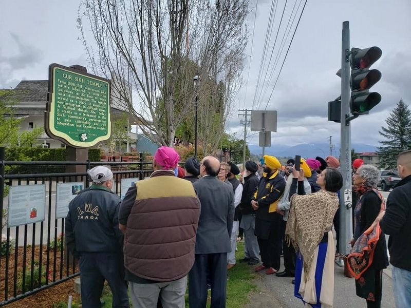
From 1908-1911, determined Sikh Settlers laboured to build this Gurdwara in the face of much racial discrimination. The temple served as a place of solace for new immigrants in difficult times. A National Historic Site, today it stands as a . . . — — Map (db m187881) HM
In 1924, by a system of stream diversions, dams, dykes, canals and pumps, 33,000 acres of fertile land were reclaimed from Sumas Lake. Few areas in B.C. have such rich soil with transportation and markets in close proximity. Produce of the mixed . . . — — Map (db m187960) HM
Chilliwack City Hall
Completed in 1912, this building is the only pre-1930
Canadian municipal hall constructed entirely of reinforced concrete. In size and purpose it is typical of a
class of modestly scaled civic structures . . . — — Map (db m303145) HM
Built in 1861, Christ Church is a fine example of the mid-19th-century revival of mediaeval Gothic forms in religious
architecture. This use of traditional models reinforced the
broader role of the Anglican church as a stabilizing . . . — — Map (db m303143) HM
In 1942, over 21,000 Japanese Canadians were unjustifiably removed from British Columbia's coast. Tashme internment camp held over 2,644 men, women, and children who lived in 347 crude tarpaper shacks. Despite horrible living conditions, the . . . — — Map (db m187902) HM
Early Saturday morning, January 9, 1965, an enormous landslide descended into this valley of the Nicolum Creek, destroying about 3 km of the Hope-Princeton Highway.
Apparently triggered by a minor earthquake, the slide, consisting of more than 46 . . . — — Map (db m161724) HM
A bold venture, this trail crossed the mountains of southern B.C., and kept the wealth of a new land from flowing to the U.S.A. Planned by the Royal Engineers, and built in 1860-61 by Edgar Dewdney, a young engineer, it led over the mountains to . . . — — Map (db m188017) HM
With the first wave of impetuous gold seekers in 1858, the Chinese came to B.C. Following the roving white miners, these industrious and patient people gleaned the gold that others failed to mine. With baskets and hand tools they helped to build the . . . — — Map (db m187906) HM
This was the head of navigation on the Fraser River. Founded in 1848, as a Hudson's Bay Company fur post, Fort Yale later became a roaring gold-rush town and for 20 years was the starting point of the famous Cariboo Wagon Road. Yale faded with the . . . — — Map (db m187996) HM
Construction of the Alexandra suspension bridge was the greatest achievement of one of British Columbia's first civil engineers, Joseph Trutch. Chief Commissioner of Lands and Works after 1864, he sat on the colony's Legislative Council. He led the . . . — — Map (db m187990) HM
By 1868, the gold rushes that had founded British Columbia were over, the public debt was soaring and many were dissatisfied with the colonial government. On September 14, 1868, 26 delegates from all over the colony met at Yale for a convention of . . . — — Map (db m187945) HM
Cliff Garten Studio
Bright Waters, 2021
Cast recycled concrete and crushed glass benches
Stainless steel luminaires and LED lights
Etched and painted granite
Bright Waters is a celebration of water in Burnaby and . . . — — Map (db m308036) HM
When New Westminster was incorporated as the first capital city of British Columbia in 1860, Colonel R.C. Moody, a Royal Engineer, developed a a plan to defend the city from American attack. Moody built the False Creek Trail (now Kingsway) to . . . — — Map (db m307941) HM
When the Province dedicated Central Park for the public's enjoyment in 1891, one of the first structures erected in the original picnic grounds was an octagonal Queen Anne styled bandstand. It served as a stage for civic events and as a shelter . . . — — Map (db m308039) HM
In 1935, to celebrate the Jubilee of King George V. Burnaby May Queen Clara Woodridge dedicated Jubilee Grove as a garden in Central Park. The garden was later chosen as site for the ceremonial dedication of an oak tree from the Royal Forest at . . . — — Map (db m308025) HM
In memory of our fallen comrades
World War I 1914 1918
World War II 1939 1945
Korea 1950 1953
They shall not grow old as we who are left grow old.
Age shall not weary them nor time condemn.
At the going down of the sun and . . . — — Map (db m307876) WM
This plaque was unveiled by Their Royal Highnesses, The Prince and Princess of Wales, to commemorate the dedication and opening of Variety Park Playground.
May 6, 1986
Burnaby, British Columbia — — Map (db m307949) HM
This site, on the world's greatest salmon river, lured many pioneer canners in the late 1860's and early 1870's. Pre-eminent was Alexander Ewen, a founder and first president of B.C. Packers, who established a cannery here in 1871. The new salmon . . . — — Map (db m187923) HM
Fort Langley was built by the Hudson's Bay Company
2½ miles below this site in 1827, and moved here in
1839. It burned and was rebuilt in 1840. As fur
resources were exhausted, supply replaced trade as the
fort's major role. Here . . . — — Map (db m284484) HM
This plaque was unveiled on October 21, 2000 as part of the New Westminster Public Library's celebration of 135 years of service to the community. It commemorates the Carnegie Library which opened on March 5, 1905 on this site and continued to . . . — — Map (db m32130) HM
Arriving in British Columbia from the United States in 1859, Scottish-born Capt. William Irving pioneered the riverboat trade of the lower Fraser River. In 1862-64, Royal Engineers built his fine home of California redwood in the popular San . . . — — Map (db m187992) HM
On September 10 & 11, 1898,
fire destroyed the
downtown portion of
the City. After the
conflagration only these two
major buildings in this area remained:
the Burr Block
and the Queens Hotel.
This marker is placed in
recognition . . . — — Map (db m32209) HM
The New Westminster Court House
The Court House was designed by architect George William Grant and opened on June 3, 1891 by the first colonial judge and Chief Justice for British Columbia, Sir Matthew Baillie Begbie.
On September 10, . . . — — Map (db m33185) HM
The Pacific Great Eastern Railway Station was built to service a rail link between North Vancouver westward along Howe Sound to the interior of the province. The foot of Lonsdale became a busy transportation hub in the early days of the community as . . . — — Map (db m31979) HM
{In English:} The oldest surviving mission church in the Vancouver area has long been a focal point of the Mission Reserve. Chief Snat, a renowned Squamish leader, assisted by the Oblate missionaries, was largely responsible for building the . . . — — Map (db m32481) HM
Colonel R.C. Moody, R.E., recognized the potential value of Burrard Inlet for military defence. Named in his honour, Port Moody became the western terminus of the Canadian Pacific Railway. Although a branch line was built in 1887 to the growing city . . . — — Map (db m187971) HM
This plaque commemorates the successful partnership between the Vancouver International Airport Authority and B.C. Hydro in developing efficient and economical electrical power solutions as well as their commitment to energy efficiency and . . . — — Map (db m255436) HM
Commemorating the start of construction of the new International Terminal and Third Runway, and dedicated to those who share the vision of Canada's Pacific Gateway,
March 25 1993.
—————————————————
Cette plaque qui commemore le . . . — — Map (db m255434) HM
In commemoration of the tenth anniversary of the terror attacks of September 11, 2001, the United States Consulate General in Vancouver, on behalf of the people of the United States, wishes to thank the people of British Columbia for their . . . — — Map (db m262193) HM WM
Officially opened by the
Right Honourable Jean Chrétien
and by the
Honourable David Anderson
Minister of Transport Canada
May 1996
————————————
Inaugurée par
le très honorable Jean Chrétien
Premier ministre du . . . — — Map (db m255437) HM
日系漁師碑
[Translation: "Japanese Fisherman Monument"]
This statue is dedicated to the pioneering Japanese fishermen and the generations
that followed for their contributions . . . — — Map (db m284486) HM
West Coast Fishery
For thousands of years the fishery has been vitally important
to people on Canada's west coast. It provided food for
Aboriginal peoples and is still an essential element of their
culture. Commercial fishing . . . — — Map (db m284485) HM
Preparing the Land
When John Stewart acquired this land in 1880, only basic land clearing had occurred. The blackberry bushes and hardhack marsh provided hospitable habitat for birds and small animals, but was not suitable for successful . . . — — Map (db m61051) HM
Community Building
The first permanent structure in Elgin was the Elgin Hotel (1870). It was built as a convenient stop-over point for travellers between New Westminster and Blaine.
In 1875, four years before the incorporation of the . . . — — Map (db m60900) HM
River Routes
Located near the intersection of the King George VI Highway and the Nicomekl River, the Port Elgin area has been a crossroads for various forms of traffic for thousands of years. For centuries prior to the arrival of the first . . . — — Map (db m63715) HM
Settlement History
First Nations settlements and seasonal hunting and fishing camps existed at the mouths of rivers and along the coastal shoreline for thousands of years before Europeans reached the West Coast. These sites were near . . . — — Map (db m60901) HM
This unfortified boundary line between the
Dominion of Canada
and the
United States of America
should quicken the remembrance of the more than century old friendship between these countries
A lesson of peace to . . . — — Map (db m27450) HM
This trail was an ancient Indian travel-way linking tribal villages in the south to salmon grounds of the Fraser River.
The first white explorers, lead by Chief Trader James McMillan of the Hudson’s Bay Company passed here in December of 1824. . . . — — Map (db m60820) HM
A Trading Post on the Fraser
In 1824, James McMillan of the Hudson’s Bay Company and a party of forty-seven passed this shore on an exploratory trip from Fort George (Astoria) at the mouth of the Columbia River to the Fraser River. They . . . — — Map (db m61525) HM
John Deighton was born in Hull, England. He was an adventurer, river boat pilot and captain, but best known for his "gassy" monologues as a saloonkeeper. His Deighton House Hotel, erected here on the first subdivided lot, burned in the Great . . . — — Map (db m40204) HM
This building is an integral part of the Victory Square area dating back to 1929. The facade was renovated in 1948 by architect W.H. Birmingham. It was given Neo-classical treatments including a decorative cornice installed below the original . . . — — Map (db m54517) HM
William Harold Malkin, a wholesale grocer and general merchant, built three warehouses on Water Street within eight years. This massive brick and timber warehouse, his third, was constructed to meet the growing demand. The W.H. Malkin Co. prospered . . . — — Map (db m236408) HM
You are standing on thousands of years of history. The clearing around Lumbermen's Arch has been the perfect gathering spot for generations.
Place of the Mask
The local Coast Salish named this site Xwdyxway (pronounced whoi . . . — — Map (db m236022) HM
This hotel dates back to 1887, part of the rapid development of the city prior to and upon arrival of the Canadian Pacific Railway. The original hotel here, known as Tremont House, was a wood frame building with a second floor balcony spanning the . . . — — Map (db m236472) HM
To commemorate those in the service of the Canadian Pacific Railway Company who, at the call of King and Country, left all that was dear to them, endured hardship, faced danger and finally passed out of sight of men by the path of duty and self . . . — — Map (db m277574) WM
This landmark building, completed in 1957 as the head office for BC Electric Company, is a significant example of the Internationalist style of modern architecture. Floors are cantilevered from a central load bearing concrete core and supported by . . . — — Map (db m32348) HM
BC & Yukon Chamber of Mines
Architect: John C. Day
This was built in 1926 as the corporate offices for the Royal Financial Trust Co., in Classical and Gothic ornamentation with terra cotta cladding. By 1931 the company was . . . — — Map (db m236785) HM
During its heyday, the Brockton Point Lighthouse played a key role in guiding ships safely in and out of Coal Harbour.
Early Warning System
The first Brockton Point lighthouse, built in 1890, alerted ships to shore-related dangers and . . . — — Map (db m198612) HM
Built to service the trading forts of the Hudson's Bay Company, the BEAVER regularly steamed the H.B.C.s territory between Puget Sound and Russian Alaska for 24 years. In 1862, the BEAVER was chartered to the Royal Navy and, after a refit, began a . . . — — Map (db m236206) HM
CARVED IN 1987 BY NISGA’A ARTIST NORMAN TAIT ALONG with his son Isaac, brother Robert, and nephew Ron Telek, this pole depicts how the Tait family's Eagle clan adopted the beaver as their crest, and how the eagle and raven met and shared the . . . — — Map (db m236192) HM
The local Coast Salish people gathered clams and mussels along these shores when this lagoon was a saltwater inlet of Coal Harbour.
[caption] Lost Lagoon got its name in the earl 1900s from Canadian poet Pauline Johnson, who presented the name . . . — — Map (db m236365) HM
The Byrnes Block was built after the fire of 1886 by George Byrnes. It stands on the site of the Deighton House, Gassy Jack Deighton’s second saloon and hotel.
The buildings housed the Alhambra Hotel, one of the city's fancier hotels at the . . . — — Map (db m236463) HM
Canada Pacific Railway Station
Architects: Barott, Blackader & Webster
As the terminus for the Canadian Pacific Railway, this site has been an important landmark since the completion of the railway in 1886. This Neo-Classical . . . — — Map (db m236312) HM
From May 2, to October 13, 1986, Canada Place was the home of the Canada Pavillion at the 1986 World Exposition. The Canada Pavillion images depicted in this sculpture represent the enterprise, excellence, and beauty of Canada, whose . . . — — Map (db m236378) HM
Canada Place was the Canadian Pacific Railway's Pier B-C ocean liner terminal in the 1920s. In 1982, the Government of Canada redeveloped it as the Canadian Pavilion for The Expo '86 World Fair and dedicated it as a legacy for the Canadian people. . . . — — Map (db m236308) HM
In the early 20th century, bank buildings were designed to recall classical temples and evoke a sense of permanence and dignity. The Neo-Classical design, imposing Ionic columns, decorative stonework, and prominent roof cornice of this building make . . . — — Map (db m33025) HM
This eclectic 1903 building was one of 2,507 public libraries paid for by the Scottish-American industrialist Andrew Carnegie, the richest person in the world when he retired in 1901. Carnegie believed in the "Gospel of Wealth" and gave away 90% of . . . — — Map (db m32318) HM
Ceperley Rounsefell Building
Architects: Sharp and Thompson
Built in 1921, this was the headquarters of one of the province's largest insurance and real estate firms with roots going back to the city's incorporation. Henry . . . — — Map (db m236783) HM
[Side 1]
In memory of eight persons who lost their lives
on the Chehalis sunk by the Princess Victoria
on July 21, 1906, at 2.p.m. opposite this spot.
[Side 2]
Percy James Chick ·
Wm Alfred Bertrand Hutton ·
Mamie Louice Bryce . . . — — Map (db m236125) HM
AN OLDER VERSION OF THIS POLE WAS RAISED IN THE Haida village of Skidegate about 1870. It honours the Raven Chief of Skedans and depicts the chief's hereditary crests. The two tiny figures in the bear's ears are the chief's daughter and son-in-law . . . — — Map (db m236187) HM
IN KWAKWAKA'WAKW (KWAKIUTL) CEREMONIES, CARVED staffs called talking sticks are held by people making important speeches on behalf of a chief. This pole represents the talking stick and characters in an Owikeno story belonging to Chief Wakas. The . . . — — Map (db m236193) HM
Cordage Building
Architect: Hugh Braunton
This residential hotel built in 1911 replaced an older section of the Granville Hotel which had connected to what is now the Grand Hotel to the west. Its elegant Edwardian and Classical . . . — — Map (db m236411) HM
Originally built to access the North Shore, the Lions Gate Bridge is now one of the city's busiest thoroughfares with over 60,000 vehicles driving across each day.
Tension over the Suspension
In 1927, Vancouverites voted against building a . . . — — Map (db m198590) HM
This unusual building is one of the few surviving Art Deco buildings in downtown Vancouver. Its roofline an exuberant crenelated cornice built in cast concrete and designed in a curvilinear waterfall theme. Downing is best known as the architect of . . . — — Map (db m41926) HM
As ships navigated the Narrows' powerful tidal flows, they relied on warnings from the Prospect Point Lighthouse to stay clear of its rocky hazards.
Response to Disaster
In 1888, just off this point, the historic steamship S.S. Beaver ran . . . — — Map (db m198611) HM
Once a thriving logging town, the downtown of Vancouver's skyline is now dominated by
residential and retail developments, corporate headquarters, hotels and the distinctive
"sails" of the convention and cruise ship centre. The City of Vancouver . . . — — Map (db m236126) HM
This fortress-like building has served as the drill hall and armoury for the British Columbia Regiment since its opening by HRH the Duke of Cornwall and York in 1901. The solid building with three-foot thick walls, was constructed of Gabriola Island . . . — — Map (db m54225) HM
James Till PhD and Ernest McCulloch MD are globally recognized as the Fathers of Stem Cell Science for their research in the 1960s at the Ontario Cancer Institute and Princess Margaret Hospital, Toronto. They received Canada's Gairdner . . . — — Map (db m236487) HM
On this site the Regina Hotel, the only building in Gastown to survive the fire of 1886. A small group of men trapped in the building fought to save their lives and managed to save the building as well. The Regina was demolished in 1906 and replaced . . . — — Map (db m236401) HM
This area was the site of a coast defence fort manned during WW II
1939-1945
by The Royal Canadian Artillery
Batteries
31st Heavy
58th Heavy
85th Heavy — — Map (db m54578) HM
In 1888, the Bank of British Columbia and the Bank of Montreal became the first of many financial institutions to open their offices on Hastings Street west of Cambie. By 1912, Hastings was firmly established as the city's financial district with . . . — — Map (db m236313) HM
First Known AIDS Memorial
Planted on October 20, 1985
The grove was planted, and this plaque donated by staff friends and loved ones of AIDS Vancouver.
This grove of cherry trees is a living monument, planted in loving . . . — — Map (db m236211) HM
In the area then known as West Capilano, and today as Ambleside, a former Canadian Pacific Railway conductor. John Lawson, purchased land in 1906. He moved his family there the following year, Lawson had big ideas for his land, which he christened . . . — — Map (db m235892) HM
Thomas Flack commissioned this landmark commercial building in 1898, following his return from a prosperous venture to the Klondike gold fields. Completed in 1900, it framed one of the city's most prominent intersections, facing the first provincial . . . — — Map (db m53619) HM
This grassy area, now Devonian Harbour Park, represents lavers of historic use from early settlement to industrial waterfront.
Coal Harbour
In 1859 Captain George Henry Richards from the British Royal Navy named this bay Coal Harbour, . . . — — Map (db m235893) HM
GA'AKSTALAS, CARVED BY WAYNE ALFRED AND BEAU DICK IN 1991, is based on a design by Russell Smith. The pole depicts many important figures in Kwakwaka'wakw culture. Red Cedar-bark Man is an ancestor who survived the great flood and gave the people . . . — — Map (db m236188) HM
This clock is located at the western boundary of the old Granville townsite, known as Gastown. In 1870, the shore of Burrard Inlet was only a few yards north of this point. Through the early 1900's, Gastown was the commercial centre of Vancouver. . . . — — Map (db m236389) HM
George Leslie's Lane Cottage
Builder: George Leslie
This circa 1901 Yaletown home was relocated to Mole Hill in 2002 and restored by the Vancouver Heritage Foundation. It was originally situated on the lane at [t]he rear of . . . — — Map (db m236746) HM
Greenshields Building
Builder: J.J. McLuckie
This former Warehouse was constructed in 1901-02 as two separate buildings designed to appear as one. Greenshields, Son & Company was a prominent Montreal-based dry goods firm which . . . — — Map (db m236396) HM
Commemorating the pioneering of the work of the Salvation Army in Vancouver. It was on this clearing the Salvation Army erected a rugged shelter, picnic tables, and then held services of song. In the silent atmosphere of early Burrard Inlet, the . . . — — Map (db m236209) HM
"The will to do, the soul to dare"
Sir Walter Scott
Harry Winston Jerome
Born September 30, 1940
Died December 7, 1982
British Columbia's Athlete
of the Century 1871-1971
World Records
1960 100 yards 9.3 seconds
. . . — — Map (db m236027) HM
Her Majesty's Canadian Ship Discovery was commissioned on November 1, 1941. Thousands of men and women have been recruited and trained at these naval reserve facilities of Deadman's Island for service to Canada in peace and war.
World War . . . — — Map (db m236197) HM
Here stood
Hamilton
First Land Commissioner
Canadian Pacific Railway
1885
in the silent solitude
of the primeval forest
He drove a wooden stake
in the earth and commenced
to measure an empty land
into the streets of . . . — — Map (db m40645) HM
This distinguished hovel designed in the Georgian Revival style was opened in 1927 by Edward Prince of Vale, who later became King Edward VII. Though the 1920s prominent buildings such as this were quickly replacing the area's early houses and . . . — — Map (db m236323) HM
Architects: John S. Archibald & John Schofield
In 1887, the first Hotel Vancouver opened at Georgia and Granville Streets. It was replaced in 1916 by more lavish building at the same location. In 1928, construction began on the third and . . . — — Map (db m236318) HM
The totem was the British Columbia Indian's "Coat of arms", totem poles are unique to the North west coast of B.C. and lower Alaska. They were carved from western red cedar and each carving tells of a real or mythical event. They were not idols, nor . . . — — Map (db m236186) HM
This ancient symbol of the Inuit culture is traditionally used as a landmark and navigational aid and also represents northern hospitality and friendship. Constructed of grey granite by Alvin Kanak of Rankin Inlet, this monument was commissioned by . . . — — Map (db m236351) HM
Jack Poole was a giant or a man, a builder of better communities who voluntarily provided
exceptional leadership with an unwavering commitment to the public good as exemplified by his extraordinary service as Chairman of the Vancouver Organizing . . . — — Map (db m236212) HM
Japanese Canadian War Memorial
This monument was dedicated on April 9, 1920 in lasting memory of more than 222 who answered the call of duty for Canada and to the 54 who sacrificed their lives in defense of freedom in WWI. Engraved on the . . . — — Map (db m236009) HM
KWARWARA' WARW CARVER ELLEN NEEL AND HER UNCLE Mungo Martin were among the first artists to achieve wide recognition for their totem poles commissioned by museums, cities, and art collectors. Neel was also the first woman to become a Northwest . . . — — Map (db m236194) HM
On May 23, 1914, the steamship Komagata Maru arrived in Coal Harbour after a seven week crossing from Hong Kong via Japan. The ship was carrying 376 Indians from India and the Far East who claimed right of entry as citizens of the British Empire. . . . — — Map (db m236311) HM
The Guinness brewing family built the Lions Gate Bridge which opened in 1938 to provide access to its British Properties lands in West Vancouver. Ownership was transferred to the Province in 1955. Tolls were removed in 1963 and the bridge was . . . — — Map (db m236789) HM
Since 1907, generations of Vancouverites have arranged downtown rendevous with one simple phrase - "meet you under the Birks clock!"
Erected as "a public convenience for the people of Vancouver", this stalwart timepiece has stood in front of . . . — — Map (db m32970) HM
This was one of the first parking garages in Vancouver, opened in 1930. It was operated by Nagle Bros. until 1937, an early service facility for tracks that moved goods from Gastown warehouses. In the late 1940s it became the Water Street Garage. . . . — — Map (db m236412) HM
This gun is a naval type twelve pound muzzle-loader. Cast in 1816 at Woolwich, England, it was brought to Vancouver around 1894. The crests of King George III and of the Earl of Mulgrave, Master General of Ordnance are on the barrel.
Gun . . . — — Map (db m33868) HM
Orpheum Theatre
Architects: B. Marcus Priteca & Frederick J. Peters
The Orpheum, built and financed by local entrepreneur Joseph F. Langer, was part of the Chicago-based Orpheum Circuit theaters. It opened in 1927 as the largest . . . — — Map (db m236733) HM
FIRST NATIONS ORIGIN STORIES TELL OF THE ANIMALS AND supernatural beings who helped found family lineages. These stories are celebrated in songs, dances, and totem pole carvings. Kwakwaka'wakw artist Oscar Maltipi carved this pole in 1968. . . . — — Map (db m236190) HM
Percy williams blasted down the track in Amsterdam at the 1928 Olympic Games to win gold in the 100 and 200 meter sprints. His unexpected Olympic victories catapulted the twenty year old, and his hometown of Vancouver, into the international . . . — — Map (db m236713) HM
176 entries matched your criteria. The first 100 are listed above. The final 76 ⊳