76 entries match your criteria.
Juan Bautista de Anza National Historic Trail Historical Markers
Congress established the Juan Bautista de Anza National Historic Trail in 1990. The trail commemorates Anza's legacy of establishing the first Spanish overland expedition to settle California.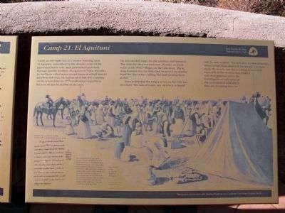
By Richard Denney, November 22, 2010
Camp 21 - El Aquituni Marker
| 1 ► Arizona, Pinal County, Picacho — Juan Bautista de Anza National Historic Trail / Camp 21: El Aquituni — |
| 2 ► Arizona, Santa Cruz County, Tubac — Juan Bautista de Anza — 1734 - 1788 — |
| On Burruel Street, on the right when traveling north. | |||
| 3 ► Arizona, Santa Cruz County, Tubac — Tubac — |
| 4 ► Arizona, Santa Cruz County, Tubac — Tubac Presidio — |
| 5 ► Arizona, Santa Cruz County, Tumacacori — Mission San José de Tumacácori — |
| On East Frontage Road, on the right when traveling north. | |||
| 6 ► Arizona, Yuma County, Yuma — Crossing Into History — Juan Bautista de Anza National Historic Trail — |
| Near Prison Hill Road. | |||
| 7 ► Arizona, Yuma County, Yuma — Juan Bautista de Anza National Historic Trail — |
| Near Prison Hill Road, 0.5 miles north of Harold C. Giss Parkway. | |||
| 8 ► Arizona, Yuma County, Yuma — The All-important Colorado River Crossing — Juan Bautista de Anza National Historic Trail — |
| Near Prison Hill Road, 0.5 miles north of Harold C. Giss Parkway. | |||
| 9 ► California, Alameda County, Fremont, Canyon Heights - Vallejo Mills — Paths Through a Varied Landscape — Anza Expedition of 1776 — |
| Near Old Canyon Road. | |||
| 10 ► California, Alameda County, Fremont, Mission San Jose — De Anza Expedition 1775 - 1776 — |
| Near Mission Boulevard. | |||
| 11 ► California, Alameda County, Hayward — A Chance Encounter — Un Encuentro Casual — |
| On City Center Drive near 2nd Street, on the right when traveling north. | |||
| 12 ► California, Alameda County, Hayward — Juan Bautista de Anza Expedition Campsite #98 — |
| On Foothill Boulevard (U.S. 238) at City Center Drive, on the right when traveling north on Foothill Boulevard. | |||
| 13 ► California, Alameda County, Hayward — Legacy of Change — |
| On City Center Drive near 2nd Street, on the right when traveling north. | |||
| 14 ► California, Alameda County, Hayward — Search for Water — |
| On City Center Drive near 2nd Street, on the right when traveling east. | |||
| 15 ► California, Alameda County, Livermore — William M. Mendenhall 1823 – 1911 / De Anza Expedition Campsite — |
| Near Livermore Avenue. | |||
| 16 ► California, Alameda County, Oakland, St Mary's Cemetery — Governor Juan Bautista Alvarado — Martina Castro de Alvarado — |
| Near Howe Street near Pleasant Valley Avenue, on the right when traveling east. | |||
| 17 ► California, Alameda County, San Leandro, Farrelly Pond District — De Anza Expedition 1775 - 1776 — |
| Near East 14th Street (State Highway 185) near Toler Avenue. | |||
| 18 ► California, Alameda County, Union City — Signs of Change — Anza Expedition of 1776 — |
| Near May Road. | |||
| 19 ► California, Contra Costa County, Concord — De Anza Expedition 1775-1776 — |
| On Grant Street south of Olivera Road, on the left when traveling north. | |||
| 20 ► California, Contra Costa County, Crockett — Anza Expedition of 1776 — |
| Near Carquinez Scenic Drive, 0.7 miles east of Winslow Street. | |||
| 21 ► California, Contra Costa County, El Cerrito — Corridors of Change — Senderos del Cambio / 变化的走廊 — |
| On San Pablo Avenue at Manila Avenue, on the right when traveling north on San Pablo Avenue. | |||
| 22 ► California, Contra Costa County, Martinez — 511 — The Vicente Martinez Adobe - 1849 — |
| Near Alhambra Avenue, on the right when traveling north. | |||
| 23 ► California, Contra Costa County, Martinez — 511 — Vicente Martinez Adobe — |
| Near Alhambra Avenue, on the right when traveling south. | |||
| 24 ► California, Contra Costa County, Oakley — "...What we see and have before us is not a river, but much water in a pond" — Anza Expedition of 1776 — |
| Near Bridgehead Road. | |||
| 25 ► California, Contra Costa County, Oakley — Anza Expedition Campsite 101 — |
| Near Bridgehead Road. | |||
| 26 ► California, Contra Costa County, Oakley — Stopped by Impenetrable Marshes — Anza Expedition of 1776 — |
| 27 ► California, Contra Costa County, Richmond — Where the Deer and the Antelope Play — Anza Expedition of 1776 — |
| Near Park Avenue. | |||
| 28 ► California, Contra Costa County, Rodeo — The De Anza Expedition in Rodeo — |
| On Parker Avenue south of 4th Street, on the right when traveling north. | |||
| 29 ► California, Imperial County, El Centro — 1008 — Yuha Well — |
| On Interstate 8 at milepost 108, on the right when traveling east. | |||
| 30 ► California, Imperial County, Ocotillo — De Anza Overlook — |
| On Anza Trail Road. | |||
| 31 ► California, Imperial County, Ocotillo — Yuha Well — (Santa Rosa de Las Lajas) — |
| Near Anza Trail Road. | |||
| 32 ► California, Los Angeles County, Los Angeles, Carthay Circle — Juan Bautista de Anza — |
| On San Vicente Boulevard at McCarthy Vista, on the right when traveling east on San Vicente Boulevard. | |||
| 33 ► California, Los Angeles County, Los Angeles, Griffith Park — Juan Bautista de Anza National Historic Trail — In Commemoration of the Anza Expedition 1775-1776 — |
| On Zoo Drive, 0.2 miles east of Riverside Drive, on the left when traveling east. | |||
| 34 ► California, Los Angeles County, Los Angeles, Griffith Park — The Feliz Family — Juan Bautista de Anza National Historic Trail — |
| On Crystal Springs Drive, 1.4 miles north of Los Feliz Boulevard, on the right when traveling north. | |||
| 35 ► California, Los Angeles County, Los Angeles, Northeast Los Angeles — Confluence of Waters and Cultures — Los Angeles River Center — Lawry’s California Center — |
| On San Fernando Road at Avenue 26, on the left when traveling south on San Fernando Road. | |||
| 36 ► California, Los Angeles County, Los Angeles, West Hills — Upper Las Virgenes Canyon — Open Space Preserve — History — |
| Near Victory Boulevard, 0.8 miles west of Valley Circle Boulevard, on the right when traveling west. | |||
| 37 ► California, Los Angeles County, San Dimas — La Cienega, Mud Springs, Birthplace of San Dimas |
| On Arrow Highway west of San Dimas Canyon Road, on the right when traveling west. Reported missing. | |||
| 38 ► California, Los Angeles County, San Gabriel — 1776 Overland Immigration Expedition — |
| On south Mission Drive, on the right when traveling south. | |||
| 39 ► California, Los Angeles County, San Gabriel — Lt. Colonel Juan Bautista de Anza — |
| On South Mission Drive, on the right when traveling north. | |||
| 40 ► California, Monterey County, Carmel-by-the-Sea — Lt. Colonel Juan Bautista De Anza — |
| On Rio Road, on the right when traveling north. | |||
| 41 ► California, Monterey County, Jolon — De Anza Expedition 1775 - 1776 — (Mission San Antonio de Padua) — |
| Near Mission Road, 6.2 miles Jolon Road (County Route G14). | |||
| 42 ► California, Monterey County, King City — De Anza Expedition 1775-1776 — |
| On San Lorenzo Park Road, on the right when traveling north. | |||
| 43 ► California, Monterey County, Monterey — De Anza Expedition — |
| On Church Street east of Figueroa Street, on the right when traveling east. | |||
| 44 ► California, Monterey County, Monterey — Juan Bautista de Anza — 1734 – 1788 — |
| On Fremont Street at Camino El Estero, on the right when traveling east on Fremont Street. | |||
| 45 ► California, Monterey County, Soledad — The De Anza Expedition in Soledad — |
| Near Fort Romie Road east of Mission Road. | |||
| 46 ► California, Riverside County, Anza — 103 — De Anza Camp — San Carlos Pass — |
| Near Coyote Canyon Road at Mangalar Road. | |||
| 47 ► California, Riverside County, Riverside — 787 — De Anza Crossing of the Santa Ana River — California Registered Landmark No. 787 — 1775 and 1776 — |
| Near Moraga Avenue, on the right when traveling south. | |||
| 48 ► California, San Benito County, San Juan Bautista — A Changing World — Juan Bautista de Anza National Historic Trail — |
| Near Old Stage Road near Salinas Grade Road. | |||
| 49 ► California, San Benito County, San Juan Bautista — De Anza Expedition 1775 – 1776 — |
| On Second Street, on the right when traveling north. | |||
| 50 ► California, San Diego County, Anza-Borrego Desert State Park — 673 — San Gregorio — |
| 51 ► California, San Diego County, Anza-Borrego Desert State Park — 634 — The Anza Trail — |
| On Horse Camp Road, on the left. | |||
| 52 ► California, San Diego County, Borrego Springs — 785 — Santa Catarina — |
| 53 ► California, San Diego County, Ocotillo Wells — 635 — Los Puertecitos — |
| On State Highway 78 east of Wolfe Well Road, on the right when traveling east. | |||
| 54 ► California, San Francisco City and County, San Francisco, Presidio of San Francisco — 82 — Castillo de San Joaquin — |
| 55 ► California, San Francisco City and County, San Francisco, Presidio Terrace — Juan Bautista de Anza — |
| 56 ► California, San Francisco City and County, San Francisco, Presidio Terrace — The Anza Expedition Camped Here — |
| 57 ► California, San Luis Obispo County, San Luis Obispo — De Anza Expedition 1775 - 1776 — |
| Near Monterey Street. | |||
| 58 ► California, San Luis Obispo County, San Luis Obispo — Juan Bautista de Anza National Historic Trail — |
| On Chorro Street at Monterey Street, on the right when traveling south on Chorro Street. | |||
| 59 ► California, San Mateo County, Burlingame — 48 — Anza Expedition Camp — |
| On El Camino Real (California Route 82) at Howard Street, on the right when traveling north on El Camino Real. | |||
| 60 ► California, San Mateo County, San Mateo — 47 — Historic Camp Site — Juan Bautista de Anza Expedition — |
| On Arroyo Court west of Dartmouth Road, on the right when traveling west. | |||
| 61 ► California, Santa Clara County, Alviso — Water Everywhere — Water Seeks Its Own Level — |
| On Hope Street. | |||
| 62 ► California, Santa Clara County, Campbell, Downtown — De Anza Expedition — 1775 - 1778 — |
| On Rincon Avenue near Dot Avenue, on the left when traveling west. | |||
| 63 ► California, Santa Clara County, Cupertino — 800 — Arroyo de San Joseph Cupertino — |
| On McClellan Road east of Bryne Road, on the right when traveling east. | |||
| 64 ► California, Santa Clara County, Hollister — Ancient Paths — |
| Near Casa de Fruta Parkway near Pacheco Pass Highway (California Route 152). | |||
| 65 ► California, Santa Clara County, Morgan Hill — [Morgan Hill] Centennial Project — A History Trail — Dedicated November 10, 2006 — |
| On Monterey Road (California Route 82). | |||
| 66 ► California, Santa Clara County, Morgan Hill — Are We There Yet? — |
| On Palm Avenue near Valley Oaks Drive. | |||
| 67 ► California, Santa Clara County, Morgan Hill — de Anza Expedition — 1775-1776 — |
| Near Sunnyside Avenue near Via Vivaldi, on the right when traveling north. | |||
| 68 ► California, Santa Clara County, Morgan Hill — De Anza Expedition 1775 - 1776 — |
| On Monterey Road (Highway 82), on the right when traveling south. | |||
| 69 ► California, Santa Clara County, San Jose, Dartmouth — De Anza Expedition 1775 - 1776 — |
| On Meridian Avenue at Princeton Drive, on the right when traveling south on Meridian Avenue. | |||
| 70 ► California, Santa Clara County, San Jose, Downtown San Jose — The Juan Bautista de Anza Trail — |
| On West Saint John Street west of North San Pedro Street, on the right when traveling east. | |||
| 71 ► California, Santa Clara County, San Jose, Rancho Santa Teresa — The Bernal Adobe Site and Bear Tree — |
| Near Curie Drive east of Korhummel Way, on the right when traveling east. | |||
| 72 ► California, Santa Clara County, Santa Clara — De Anza Expedition 1775 – 1776 — |
| On El Camino Real (State Highway 82), on the right when traveling north. | |||
| 73 ► California, Santa Clara County, Santa Clara — The Berryessa Adobe — This Adobe House — Culture and Structure Together — |
| On Jefferson Street, on the left when traveling south. | |||
| 74 ► California, Santa Clara County, Saratoga — 435 — Saratoga — (Formerly Toll Gate, McCartysville, Bank Mills) — |
| On Saratoga-Sunnyvale Road (California Route 9) at Saratoga-Los Gatos Road on Saratoga-Sunnyvale Road. | |||
| 75 ► California, Santa Clara County, Sunnyvale, Heritage District — De Anza Expedition 1775 - 1776 — |
| Near North Sunnyvale Avenue east of East California Avenue. | |||
| 76 ► California, Ventura County, Westlake Village — Triunfo Canyon — Conejo Valley — |
| On Westlake Boulevard at Triunfo Canyon Road, on the left when traveling south on Westlake Boulevard. | |||